Downpour
04 July 2019 07:55:05
A fine, benign, classic English summer output. ‘The six weeks of unsettled/summer is over’ garbage seems a distant memory now.


Chingford
London E4
147ft
richardabdn
04 July 2019 12:13:47

Originally Posted by: doctormog 

With all this talk about fairy stories and weather I was expecting the outlook to be Grimm.


Grim doesn’t even begin to describe the vile and disgusting outlook. I would say a repeat of July 2012 but that wouldn’t be fair. Even in that astoundingly awful month we saw two afternoons/early evenings of warm sunshine and 20C during the first week. Nothing remotely acceptable so far this month or in the outlook. Just endless grey skies, cool temperatures and almost daily rain or drizzle.


We had 93 hours sun in the first week of July 2018 and at this rate we won’t even reach that for the whole of this month. Not just NW Highland summer weather but bad NW Highland summer weather


Aberdeen: The only place that misses out on everything


2023 - The Year that's Constantly Worse than a Bad November
picturesareme
04 July 2019 12:55:15

Originally Posted by: Downpour 

A fine, benign, classic English summer output. ‘The six weeks of unsettled/summer is over’ garbage seems a distant memory now.


when was there 6 week's? I recall around 2 week's perhaps 2.5 weeks for some, but thats pretty much standard even if it was wetter than average.

Tim A
04 July 2019 14:07:07

Originally Posted by: picturesareme 


when was there 6 week's? I recall around 2 week's perhaps 2.5 weeks for some, but thats pretty much standard even if it was wetter than average.


There wasn't.  But I think the point was some people were writing months off with pessimistic 'Summer is over' type posts. 


Tim
NW Leeds
187m asl


Downpour
04 July 2019 19:50:37

Originally Posted by: picturesareme 


when was there 6 week's? I recall around 2 week's perhaps 2.5 weeks for some, but thats pretty much standard even if it was wetter than average.


I’m referring to the hyperbolic posts in early June, not the actual weather!


Chingford
London E4
147ft
Ally Pally Snowman
05 July 2019 07:08:14

ECM and GFS particularly settled this morning all the way to day 10 a little blip day 6ish but nothing much to worry about. No sign yet of the unsettled July that some of the Pros have forecast. Hopefully stays like that.


Bishop's Stortford 85m ASL.
xioni2
05 July 2019 09:15:21

Originally Posted by: Ally Pally Snowman 


ECM and GFS particularly settled this morning all the way to day 10 a little blip day 6ish but nothing much to worry about. No sign yet of the unsettled July that some of the Pros have forecast. Hopefully stays like that.


The ECM is not settled at all actually.

Essan
05 July 2019 10:19:22

Originally Posted by: xioni2 


The ECM is not settled at all actually.


Apart from Saturday it has HP dominating throughout. 


Andy
Evesham, Worcs, Albion - 35m asl
Weather & Earth Science News 

Anyone who is capable of getting themselves made President should on no account be allowed to do the job - DNA
DEW
  • DEW
  • Advanced Member
05 July 2019 10:30:21

Charts generally look a bit unpredictable to me, with the col over the UK subject to disturbance from any one of the four points of the compass. Latest ideas seem to have HP from the SW predominating, but there's a hint of thundery stuff from the south about T+150, and then much colder from the north at the end of the GFS run. But I wouldn't put money on either.


War does not determine who is right, only who is left - Bertrand Russell

Chichester 12m asl
xioni2
05 July 2019 10:32:06

Originally Posted by: Essan 


Apart from Saturday it has HP dominating throughout. 


No, it has rain on most days (later next week).

bledur
05 July 2019 13:40:38

Originally Posted by: xioni2 


No, it has rain on most days (later next week).


.


 Yes most models now showing a higher chance of rain wednesday onwards with a drier weekend to follow before it turns generally  wetter again.

JOHN NI
05 July 2019 15:33:26

Originally Posted by: bledur 


.


 Yes most models now showing a higher chance of rain wednesday onwards with a drier weekend to follow before it turns generally  wetter again.


Yes presently models would suggest a slight move towards weak progression by mid-July rather than the quasi-blocking that been so dominant so far this summer. Ive no time for the St Swithens theory as such but pattern changes in mid-July tend to set the pace for the remainder of the 'high' summer period - ie up until the last week of August.  An abrupt pattern change late July/early August would be the exception.


However all the  best trends fail once in a while.  Here's hoping. 


John.
The orange County of Armagh.
Essan
05 July 2019 15:35:45

Originally Posted by: xioni2 


No, it has rain on most days (later next week).


It may well do for some places.  But it also has 1020mb+ over most of the UK.  


Andy
Evesham, Worcs, Albion - 35m asl
Weather & Earth Science News 

Anyone who is capable of getting themselves made President should on no account be allowed to do the job - DNA
xioni2
05 July 2019 16:15:29

Originally Posted by: Essan 


It may well do for some places.  But it also has 1020mb+ over most of the UK.  


That's not very relevant in this case, we were talking whether that run was showing settled conditions or not. 

Stormchaser
05 July 2019 19:29:54

An impressively 'warm' low from the northwest next Thu-Fri according to the majority vote of the 12z runs - but this feature's been coming and going a lot, and in such a generally vague setup across the N. Atlantic and into Europe, I'd not want to place any bets!


Models don't seem to have a flying clue how far east ridging will extend from the Azores, and how much this will be able to dictate the movement of various areas of shallow low pressure.
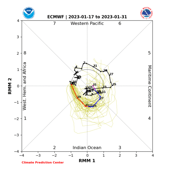


This transient uptick in western Indian Ocean convection may just about to enough to retract the ridge more west of the UK for a time until around mid-month, after which renewed extension east is most probable provided the Nino base state persists (which it looks likely to do, once you allow for typical model bias).


A possible wildcard remains the Arctic blocking - it seems it will be weakening overall, but this change is showing signs of being less smooth than initially put forward by the models. Often the way with such processes. Also happens with the initiation of blocking, as we've seen all too often in the winter season.


If you have any problems or queries relating to TWO you can Email [email protected] 🙂
https://twitter.com/peacockreports 
2021's Homeland Extremes:
T-Max: 30.4°C 21st Jul | T-Min: -6.8°C New Years Day! | Wettest Day: 34.1mm 2nd Oct | Ice Days: 2 (27th Jan & 8th Feb)
Keep Calm and Forecast On
Essan
05 July 2019 19:47:21

Originally Posted by: xioni2 


That's not very relevant in this case, we were talking whether that run was showing settled conditions or not. 


Which it is.   No sign of rampant westerlies or low pressure dominating.   


Andy
Evesham, Worcs, Albion - 35m asl
Weather & Earth Science News 

Anyone who is capable of getting themselves made President should on no account be allowed to do the job - DNA
DEW
  • DEW
  • Advanced Member
07 July 2019 06:38:35

HP from the southwest continues to offer mainly dry and sunny weather, though only average temperatures according to GFS.


But it's not firmly connected to the Azores high so breaks down at times; fronts brushing N Scotland, a thundery interlude in the SE on Thu/Fri (lots of fronts going nowhere in particular on the fax chart), and deep in FI (eg GFS Wed 17th) some sub-552dam air for Scotland. 


Cold air currently giving the Baltic / W Russia some very unsummery temps 6C or so below normal for the next couple of weeks
http://www.wxmaps.org/pix/temp4


War does not determine who is right, only who is left - Bertrand Russell

Chichester 12m asl
Bertwhistle
07 July 2019 06:48:28

With a period of almost col-like conditions appearing in the models, and consequently no dominant defined feature, I wonder if (and perhaps hope that) the models might struggle to project, and hence the rather bland outputs on offer. A remarkably flat line, excluding the outliers, in the GEFS, with no general trend either way:


No chart available for the selected hour. Many charts start at 3 hours ahead, so if you have 0 hours selected try stepping forward or selecting a later hour.


Bertie, Itchen Valley.
'We'll never see 40 celsius in this country'.
TimS
  • TimS
  • Advanced Member
08 July 2019 07:46:27
Quite an interesting few days of model watching ahead. We’re getting into the key period of high summer where the pattern will make or break the season, and it’s teetering on the edge of good or bad at the moment. Wet cool June, then warm settled early July, then neutral and a bit showery. Could go either way.

We seem to be in the process of switching to a positive AO. That’ll slow down the near record arctic ice melt, and return us to a more zonal pattern, but that could be good or bad news.
Brockley, South East London 30m asl
RobN
  • RobN
  • Advanced Member
08 July 2019 13:20:25

Looking impressively dry in the far SW over the next week according to GFS


Rob
In the flatlands of South Cambridgeshire 15m ASL.
Users browsing this topic

Ads