Hippydave
02 October 2017 18:49:54

Toppler


Just warming up for winter


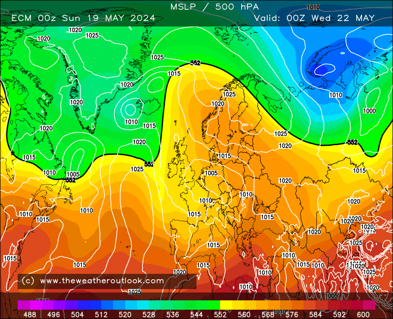
Both ECM and GFS up to T168 have the HP quickly topple over us and then settle over Europe, leaving us in a broadly West/South Westerly flow. ECM looks a little less settled to me, with HP having less of an influence, be interesting to see where the remainder of the run goes.


With the set up shown the South does best for any dryness, with it turning more unsettled the further North and West you are.


All in all pretty normal for the time of year


Home: Tunbridge Wells
Work: Tonbridge
Stormchaser
02 October 2017 19:40:51
Is it winter already? There's been a sudden large swing away from Mid-Atlantic ridging to European 😉

We'll see if it holds. Not a great time for model consistency - perhaps the disturbed vortex is a factor in this?
If you have any problems or queries relating to TWO you can Email [email protected] 🙂
https://twitter.com/peacockreports 
2021's Homeland Extremes:
T-Max: 30.4°C 21st Jul | T-Min: -6.8°C New Years Day! | Wettest Day: 34.1mm 2nd Oct | Ice Days: 2 (27th Jan & 8th Feb)
Keep Calm and Forecast On
DEW
  • DEW
  • Advanced Member
03 October 2017 06:41:47

Originally Posted by: Hippydave 


Both ECM and GFS up to T168 have the HP quickly topple over us and then settle over Europe, leaving us in a broadly West/South Westerly flow. ECM looks a little less settled to me, with HP having less of an influence, be interesting to see where the remainder of the run goes.


With the set up shown the South does best for any dryness, with it turning more unsettled the further North and West you are.


All in all pretty normal for the time of year


Rinse and repeat - looks to be mobile for the foreseeable.


War does not determine who is right, only who is left - Bertrand Russell

Chichester 12m asl
DEW
  • DEW
  • Advanced Member
04 October 2017 06:24:31

Basic westerlies for the next week, but the weekend of the 14/15th looks as if we may get more of a focused hit - ECM just gefore the weekend, GFS just after.


https://www.theweatheroutlook.com/twodata/datmdlout.aspx


War does not determine who is right, only who is left - Bertrand Russell

Chichester 12m asl
Brian Gaze
04 October 2017 07:03:53

Still time for change but the autumn doesn't look to be playing out like some of the seasonal models suggested. Things seems relatively benign for the time of year.


Brian Gaze
Berkhamsted
TWO Buzz - get the latest news and views 
"I'm not socialist, I know that. I don't believe in sharing my money." - Gary Numan
xioni2
04 October 2017 07:16:13

Originally Posted by: Brian Gaze 


Still time for change but the autumn doesn't look to be playing out like some of the seasonal models suggested. Things seems relatively benign for the time of year.


I think Oct-Dec will end up quite warm in the UK.

Brian Gaze
04 October 2017 07:41:33

Originally Posted by: xioni2 


I think Oct-Dec will end up quite warm in the UK.


To be fair there was a strong signal for above average temperatures so to that extent most of the seasonals would be right. 


Brian Gaze
Berkhamsted
TWO Buzz - get the latest news and views 
"I'm not socialist, I know that. I don't believe in sharing my money." - Gary Numan
Solar Cycles
04 October 2017 07:48:21

Originally Posted by: xioni2 


I think Oct-Dec will end up quite warm in the UK.


Its very, very early days  but up here we're running some 2c below normal and the next seven days are projected to come in around normal or just below.

Brendon Hills Bandit
04 October 2017 19:30:48
I have a (hopeful) feeling that the seasonal models will be wrong, and that autumn into winter will see no establishment of a strong polar vortex! Against the odds, but it wouldn't be the first time it has happened - the winter of 2013-14 was infamously wet, but the seasonal models were generally going for an anticyclonic winter IIRC.
220m asl, edge of Brendon Hills
DEW
  • DEW
  • Advanced Member
05 October 2017 06:25:02

ECM has it in for us on Thu 12th - 975mb centred over the North Channel, and 516 mb uppers. GFS just keeps the westerlies rolling. But the situation is quite fluid, both these models show quite different timings for disturbances compared to yesterday.


War does not determine who is right, only who is left - Bertrand Russell

Chichester 12m asl
Nordic Snowman
05 October 2017 07:21:55

Originally Posted by: Brian Gaze 


To be fair there was a strong signal for above average temperatures so to that extent most of the seasonals would be right. 


I think the likelihood for higher temperatures is pretty high (as per the norm) and would suit me fine. The only real question is whether it will be wetter or drier than normal. The temperature front is quite easy to speculate on - with or without seasonal and daily models  The weather has been stuck for ages now and can be summed up very easily and goes something like this: A NW/SE split.... most unsettled in the N and W with the driest and brightest weather in the SE. All very boring but I will be happy enough as long as the temps stay as high as possible (relative to the time of year).


Bjorli, Norway

Website 
Stormchaser
05 October 2017 08:57:31


Ouch ECM - that's a right pressure gradient you've got going on there! Good thing it's at 9 days range and at a time when GFS has a more amplified jet stream pattern that keeps the low to our NW and allows a nice warm ridge to build across NW Europe. Of course I mean warm relative to the time of year. Also note that 'nice' should only remain applicable to ridges in that location for another few weeks .


If you have any problems or queries relating to TWO you can Email [email protected] 🙂
https://twitter.com/peacockreports 
2021's Homeland Extremes:
T-Max: 30.4°C 21st Jul | T-Min: -6.8°C New Years Day! | Wettest Day: 34.1mm 2nd Oct | Ice Days: 2 (27th Jan & 8th Feb)
Keep Calm and Forecast On
Hungry Tiger
05 October 2017 12:54:32

Originally Posted by: Stormchaser 


Ouch ECM - that's a right pressure gradient you've got going on there! Good thing it's at 9 days range and at a time when GFS has a more amplified jet stream pattern that keeps the low to our NW and allows a nice warm ridge to build across NW Europe. Of course I mean warm relative to the time of year. Also note that 'nice' should only remain applicable to ridges in that location for another few weeks .


That chart James for the 14th October looks amazing.


Gavin S. FRmetS.
TWO Moderator.
Contact the TWO team - [email protected]
South Cambridgeshire. 93 metres or 302.25 feet ASL.


DEW
  • DEW
  • Advanced Member
07 October 2017 06:16:44

Difficult to say anything sensible about the models when every day brings something different. For the coming week, it looks as if we shall hang on to some warmth as the westerlies have an occasional southerly component, and stay fairly dry, bar the NW as most of the LP systems do hang around up there. Some signals for the more disturbed and cooler weather to move south in the second week, but I won't hold my breath.


http://www.wxmaps.org/pix/prec4.html


War does not determine who is right, only who is left - Bertrand Russell

Chichester 12m asl
Brian Gaze
07 October 2017 06:30:12

The most notable thing I can see is the potential warm up next week. Other than that it's an utter snooze fest IMHO. One of the most boring spells of weather I can recall and TBH there is plenty of competition. 


Brian Gaze
Berkhamsted
TWO Buzz - get the latest news and views 
"I'm not socialist, I know that. I don't believe in sharing my money." - Gary Numan
Stormchaser
07 October 2017 22:09:44
On mobile so can't post charts (the URLs won't copy!), but the ECM 12z is extraordinary by next weekend and into the following week - perfect flow alignment (also fast enough to limit fog formation) and airmass source for temps widely in the low 20s in mid-Oct, perhaps nearing mid-20s in warmest spots... for several days running!

GFS has tended to be more progressive and so was ECM up to the 00z so this run may well be a flight of fancy but I'm hoping not as such warmth so late in the year would be a special event to treasure for years to come 🙂 - cold down here at least can wait until mid-late Nov when it can be potent enough to be of interest 😉
If you have any problems or queries relating to TWO you can Email [email protected] 🙂
https://twitter.com/peacockreports 
2021's Homeland Extremes:
T-Max: 30.4°C 21st Jul | T-Min: -6.8°C New Years Day! | Wettest Day: 34.1mm 2nd Oct | Ice Days: 2 (27th Jan & 8th Feb)
Keep Calm and Forecast On
Gavin D
08 October 2017 08:34:05

GFS gets many parts of England & Wales into the high teens/low 20's by the end of the week


briggsy6
08 October 2017 08:40:20

Anyone else noticed a complete lack of mist or fog so far this Autumn? perfect comditions for fog last night, yet I woke up to gin clear skies. I blame Donald Trump myself.


Location: Uxbridge
Bertwhistle
08 October 2017 09:02:11

Originally Posted by: Gavin D 


GFS gets many parts of England & Wales into the high teens/low 20's by the end of the week


Yes, the GFS 0z op. gives a week of warmth after that, too- with warm nights throughout, that could bring one of the mildest Octobers in the series.


Bertie, Itchen Valley.
'We'll never see 40 celsius in this country'.
Bertwhistle
08 October 2017 09:08:34

This morning's ECM offers 564dam over SW England coupled with a near 15C 850mb temp.next Sunday. That's a rare thing for mid-October.


Bertie, Itchen Valley.
'We'll never see 40 celsius in this country'.
Users browsing this topic

Ads