The Weather Outlook

Remove ads from site

Saint Snow
24 June 2026 13:06:13

Most output atm seems to suggest HP will try and build in over the UK but struggle to takeover completely.  So settled for most but no heatwave imminent after this one.

Originally Posted by: Ally Pally Snowman 

I may be misremembering, but have a feeling this current one started off the same way. Then the higher temps would probably only impact the SE and be get to 30c. Then some output showed a wider region affected. And so on.

Every great oak, etc, etc*

.

.

* this adage doesn't apply to winter, where the saplings of 'great Arctic blasts' get munched by the grazing herbivores of Atlantic filth


Martin

Home: St Helens (26m asl) Work: Manchester (75m asl)

A TWO addict since 14/12/01

"How can wealth persuade poverty to use its political freedom to keep wealth in power? Here lies the whole art of Conservative politics."

Aneurin Bevan

Tom Oxon
24 June 2026 16:28:50
The 12z Arpege is out and has been performing really well in at high res in the near term, and has been bang on with a provisional 36.1C registered in Hampshire.

I think we're on for a new high tomorrow, quite a few pockets of 37C
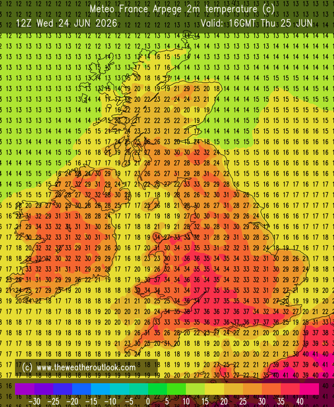
UserPostedImage

Hampshire/Wilts/Somerset/Sussex/Gloucs all have contenders.  I'd probably stick with Hants or Wilts taking the crown, 37.xC, probably high, possibly squeaking a low 38C.

The Suffolk furnance for Friday has been downgraded, tomorrow is looking like the absolute peak.


S Warwickshire countryside, c.375ft asl.
Rob K
24 June 2026 16:42:22
Yes I think we'll see a 37 tomorrow quite easily. Maybe on Friday too. GFS has 35 on Saturday too but Arpege tops out at 33.

Talking of GFS, the 12Z run seems to keep things fairly settled in the south next week with temperatures starting to climb again by next weekend.

Amazing to think we still have over two months of summer left!


Yateley, NE Hampshire, 73m asl

"But who wants to be foretold the weather? It is bad enough when it comes, without our having the misery of knowing about it beforehand." — Jerome K. Jerome

Ally Pally Snowman
24 June 2026 17:22:04

I may be misremembering, but have a feeling this current one started off the same way. Then the higher temps would probably only impact the SE and be get to 30c. Then some output showed a wider region affected. And so on.

Every great oak, etc, etc*

.

.

* this adage doesn't apply to winter, where the saplings of 'great Arctic blasts' get munched by the grazing herbivores of Atlantic filth

Originally Posted by: Saint Snow 

Well right on cue GFS 12z produces its hottest run for a while.


Bishop's Stortford 85m ASL.
Heavy Weather 2013
24 June 2026 17:35:33

Well right on cue GFS 12z produces its hottest run for a while.

Originally Posted by: Ally Pally Snowman 

I literally came here to say same, next week looks already better with HP hanging on ok in the south and then it looks like another heatwave developing, long way off but the background signal in terms of upstream pattern are favouring a repeating pattern.


Mark

Beckton, E London

Less than 500m from the end of London City Airport runway.

24 June 2026 22:55:11

The 12z Arpege is out and has been performing really well in at high res in the near term, and has been bang on with a provisional 36.1C registered in Hampshire.

I think we're on for a new high tomorrow, quite a few pockets of 37C

UserPostedImage

Hampshire/Wilts/Somerset/Sussex/Gloucs all have contenders.  I'd probably stick with Hants or Wilts taking the crown, 37.xC, probably high, possibly squeaking a low 38C.

The Suffolk furnance for Friday has been downgraded, tomorrow is looking like the absolute peak.

Originally Posted by: Tom Oxon 

I like this gives my 33/1 bet for the Scottish heat record a little boost imo 33c on the models can easily be corrected >2c in reality around these parts!

Tom Oxon
24 June 2026 22:56:34
Some last minute downgrades from the Arpege 18z on tomorrow, making 38 less likely and 37C by no means a cert.   Also wider downgrades for the east on Friday.

Some fairly lively atmospherics over northern Wales on Friday morning. pushing into Merseyside/Lancs/Cumbria/W Yorks later on.

https://www.theweatheroutlook.com/charts/arpege/18_43_ukcape.png 


S Warwickshire countryside, c.375ft asl.
24 June 2026 23:01:43

Some last minute downgrades from the Arpege 18z on tomorrow, making 38 less likely and 37C by no means a cert.   Also wider downgrades for the east on Friday.

Some fairly lively atmospherics over northern Wales on Friday morning. pushing into Merseyside/Lancs/Cumbria/W Yorks later on.

https://www.theweatheroutlook.com/charts/arpege/18_43_ukcape.png 

Originally Posted by: Tom Oxon 

Excellent them cape values are ridiculous especially for the north! 

Just a quick edit because this British understatement of ours is not doing this justice 😂

"Fairly lively"

Cape values of 3000 J/kg is pure, unadulterated American Tornado Alley weather!

24 June 2026 23:39:02

I think the trend in the GFS 12z data is pretty clear: 

https://www.wetterzentrale.de/en/ens_image.php?geoid=51243&var=201&run=12&date=2026-06-24&model=gfs&member=ENS&bw=1 

UserPostedImage

Originally Posted by: doctormog 

Dude your weather as a much relevance to the fellas in the South East of England as the polar bears weather on Svalbard does🤣🤣

DEW
  • DEW
  • Advanced Member
25 June 2026 06:33:18
FAX - LP 1010 Biscay taking over, fronts for Scotland, (thundery) troughs for S England. This LP combines with LP from the Atlantic to become 986mb south of Iceland Sun 28th pushing Atlantic fronts and presumably cooler conditions across the country before setting down to a standard westerly pattern, unsettled in the N & W, higher pressure keeping it fine in the SE.

GFS Op 0z - for w/b Sun 28th, HP tries a come-back with a ridge across N England and again warmth for the south on easterlies. This doesn't last as the HP withdraws to the Atlantic and winds go back to W-ly, then NW-ly. For w/b Sun 5th series of LPs become the controlling feature with the source of air  being the north Atlantic - .LP centres Sun 5th 990mb Faeroes, then Tue 7th 1000mb N England then Sat 11th 1005mb Cornwall 

ECM - agrees with GFS

AIFS - London, peak maximum 33C Fri 26th followed by a drop to low 20s C with a little rain Sun 28th - Fri 3rd. Then drier and progressively warmer to 30C by Fri 10th (doesn't match GFS Op). Edinburgh, a couple of peaks Thu & Sat, otherwise maxima in upper teens through to Tue 7th before rapidly rising to 25C . Quite a lot of rain in the coming week, then dry.  Winds in both cases mostly from a westerly point (London E-ly at first and S-ly at the end)

GEFS - Temps dropping from 14C above norm now(less in Scotland) to norm by Sun 28th and staying there, good agreement of mean and ens members (a few hot outliers after 5th Jul) Rain this weekend then mainly dry, perhaps some more in NW England later but more persistent in NW Scotland.

GEFS - 


It's not the voting that's democracy, it's the counting - Tom Stoppard

Chichester 12m asl

Heavy Weather 2013
25 June 2026 06:42:01
Looking at the GFS ensembles. There are a lot more runs in FI now looking quite spikey suggesting the models are toying with another heatwave - this is supported by upstream patterns. The op was an outlier, but it should be noted that next week is already looking a lot better in the south at least with more HP and very warm temps. Crazy to think 25C seems almost cold compared to recent events.
Mark

Beckton, E London

Less than 500m from the end of London City Airport runway.

doctormog
25 June 2026 06:59:37

Dude your weather as a much relevance to the fellas in the South East of England as the polar bears weather on Svalbard does🤣🤣

Originally Posted by: HighPressureGloom 

Oops sorry I didn’t realise this was the Southeast thread.

If you were less parochial and lazy you would see the pattern in the t850 ensemble charts is reflected across the country, not that the weather in only your little corner of the world is of much interest to me, I prefer to look at the bigger picture…dude.

In fact it is even more marked in the SE: https://www.wetterzentrale.de/en/ens_image.php?geoid=49069&var=201&run=0&date=2026-06-25&model=gfs&member=ENS&bw=1 


Rob K
25 June 2026 08:18:08
In the southeast (sorry!) this morning’s GFS keeps max temps at 26C or above for all of next week right out to Saturday. Not much sign of anything cold or even cool down here. 
Yateley, NE Hampshire, 73m asl

"But who wants to be foretold the weather? It is bad enough when it comes, without our having the misery of knowing about it beforehand." — Jerome K. Jerome

Charmhills
25 June 2026 08:27:18
Still on course for a cooler, fresher week next week with the odd showers around, but generally little rain away from the north,

https://www.wetterzentrale.de/en/ens_image.php?geoid=50902&var=201&run=0&date=2026-06-25&model=gfs&member=ENS&bw=1 

The Midlands, for example.


Loughborough, EM.

Knowledge is power.

Duane.

The Beast from the East
25 June 2026 09:17:02
July 7th onwards could be seeing the Azores high finally ridge across properly and pull in some of that heat down south. 

Mid July could be the next period of interest. 


Purley, Surrey, 70m ASL

"We have some alternative facts for you"

Kelly-Ann Conway - former special adviser to the President

25 June 2026 10:06:47

Oops sorry I didn’t realise this was the Southeast thread.

If you were less parochial and lazy you would see the pattern in the t850 ensemble charts is reflected across the country, not that the weather in only your little corner of the world is of much interest to me, I prefer to look at the bigger picture…dude.

In fact it is even more marked in the SE: https://www.wetterzentrale.de/en/ens_image.php?geoid=49069&var=201&run=0&date=2026-06-25&model=gfs&member=ENS&bw=1 

Originally Posted by: doctormog 

Well I live in Cumberland I can hop over to Scotland in 10 minutes, Its forecast to be 34c here this afternoon Aberdeen is 18c my point stands, Cowabunga! 🤣😂

doctormog
25 June 2026 11:39:41

Well I live in Cumberland I can hop over to Scotland in 10 minutes, Its forecast to be 34c here this afternoon Aberdeen is 18c my point stands, Cowabunga! 🤣😂

Originally Posted by: HighPressureGloom 

No, it really does not. You referred directly to the SE in reply to my comment on the overall trend on the t850hPa ensemble output! And have now followed that up with a comment about today's weather (which incidentally is glorious and also very pleasant for working).

The 06z GEFS output continues with the same t850 trend, nationwide, (in case that last word really needs to be included).


doctormog
25 June 2026 11:42:15

In the southeast (sorry!) this morning’s GFS keeps max temps at 26C or above for all of next week right out to Saturday. Not much sign of anything cold or even cool down here. 

Originally Posted by: Rob K 

No need to apologise. Given the remarkably above average temperatures at the moment, the clear trend, despite the steady decrease in coming days, still does not take temperatures to below average!


25 June 2026 17:35:29

No, it really does not. You referred directly to the SE in reply to my comment on the overall trend on the t850hPa ensemble output! And have now followed that up with a comment about today's weather (which incidentally is glorious and also very pleasant for working).

The 06z GEFS output continues with the same t850 trend, nationwide, (in case that last word really needs to be included).

Originally Posted by: doctormog 

My point if you really don't understand is that the ensemble forecast for Aberdeen has little relevance for most people in the UK even with historically high uppers Aberdeen is chilly. So posting an ensemble chart for Aberdeen in response to discussion about summer conditions holding on in the south East of England when the conditions in the same country on the same are so different, is pure folly.

The Beast from the East
25 June 2026 17:37:25
GFS 12z interesting run. The South never really cools down properly and the azores keeps trying to ridge across and eventually makes it.  Classic British Summer. warm days and comfortable nights next week for the south anyway
Purley, Surrey, 70m ASL

"We have some alternative facts for you"

Kelly-Ann Conway - former special adviser to the President

Ally Pally Snowman
25 June 2026 17:38:36
Another very warm to hot GFS 12z for the southern 3rd of the UK. 
Bishop's Stortford 85m ASL.
Brian Gaze
25 June 2026 17:40:21
Happy days next week if you're in the southern half of the UK, like warm weather and the UK Met Global is on the ball.

https://www.theweatheroutlook.com/twodata/ukmet.aspx?run=12&charthour=120&chartname=eur_Precipitation_rate&chartregion=eur&charttag=Precip%20type 


Brian Gaze

Berkhamsted

TWO Buzz - get the latest news and views 

"I'm not socialist, I know that. I don't believe in sharing my money." - Gary Numan

doctormog
25 June 2026 17:43:52

My point if you really don't understand is that the ensemble forecast for Aberdeen has little relevance for most people in the UK even with historically high uppers Aberdeen is chilly. So posting an ensemble chart for Aberdeen in response to discussion about summer conditions holding on in the south East of England when the conditions in the same country on the same are so different, is pure folly.

Originally Posted by: HighPressureGloom 

Thanks for conforming that you don’t understand what a trend in t850s means. It’s not about whether it’s going to be summery in Aberdeen or SE England it is about the fact there is a steady and marked decrease in t850s and my location was used to demonstrate that. The trend is nationwide, it it to be be honest a bit embarrassing that you don’t understand that. I suspect even the causal weather enthusiast is every well aware of the difference in climate between NE Scotland SE England. 

Your point appears to be trying to address a point that I did not make but if it makes you happy to misinterpret my post there’s little I can do to stop you.

As you have totally ignored my point once again I can only assume that in some random alternative version of the model output you don’t see the obvious trend of a decrease of the t850s from their remarkable current highs to an average level? I mean I could list more links showing that it is the same north to south but you seem unable to open them (or choose to ignore them?)


doctormog
25 June 2026 17:47:28
And as a general illustration (and now stated 3 times) it is same trend her as well as the south. If any member interprets that as suggesting it will be the same weather in the north and the south, perhaps they need to think a little more carefully

https://www.wetterzentrale.de/en/ens_image.php?geoid=49069&var=201&run=12&date=2026-06-25&model=gfs&member=ENS&bw=1 

UserPostedImage


Remove ads from site