The Weather Outlook

Remove ads from site

Brian Gaze
08 December 2022 15:58:03

Geography really isn't our friend in the south of the UK is it?

Originally Posted by: Rob K 

I've not looked at it statistically, but on balance I'd say that here in the Chilterns we see a similar amount of snow to York which is about 180 miles further north. (I'm basing it on living here and regularly talking to people who still live up there). Things possibly "deteriorate" from the snow perspective more noticeably in counties south of London. Other people may disagree with this assessment. 


Brian Gaze

Berkhamsted

TWO Buzz - get the latest news and views 

"I'm not socialist, I know that. I don't believe in sharing my money." - Gary Numan

Rob K
08 December 2022 16:00:33

Whilst I wouldn't put you in the category of some folks who are clearly just on a windup, I do think you tend to get an idea stuck in your head and run with it regardless of any evidence to the contrary.

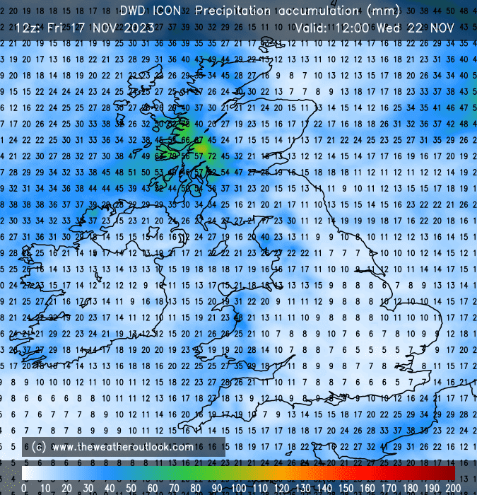
That in mind, what about this chart from the ICON says 'dry' to you? 

UserPostedImage

Originally Posted by: Hippydave 

Plenty of snow at sea!

UserPostedImage


Yateley, NE Hampshire, 73m asl

"But who wants to be foretold the weather? It is bad enough when it comes, without our having the misery of knowing about it beforehand." — Jerome K. Jerome

Hippydave
08 December 2022 16:02:51
[quote=Rob K;1498584]Plenty of snow at sea!
UserPostedImage[/quote

]

Pfft, if that was accurate I'll eat Moomins cricket box.

And for another view, same model shows show having fallen over around half the UK by T120:-

UserPostedImage


Home: Tunbridge Wells

Work: Tonbridge

moomin75
08 December 2022 16:07:55

Whilst I wouldn't put you in the category of some folks who are clearly just on a windup, I do think you tend to get an idea stuck in your head and run with it regardless of any evidence to the contrary.

That in mind, what about this chart from the ICON says 'dry' to you? 

UserPostedImage

Originally Posted by: Hippydave 

What tells me it's dry is the precipitation charts on Meteociel. They are very dry indeed.


Witney, Oxfordshire

100m ASL

Russwirral
08 December 2022 16:10:42

What tells me it's dry is the precipitation charts on Meteociel. They are very dry indeed.

Originally Posted by: moomin75 

I think people are getting mixed up here.  The reliable charts look very dry, the longer terms flip flop by the day and some look dry, the others not so.

The chart you have picked is from over a week away.  The Icon until that point only shows shower activity over the sea, and very little over land.

Therefor the onging mantra of it looking dry


Hippydave
08 December 2022 16:19:23

What tells me it's dry is the precipitation charts on Meteociel. They are very dry indeed.

Originally Posted by: moomin75 

Hmmm, they're dry but I'd be surprised if they're picking up convective enhancement from that LP and the stronger NE flow. 

They do also show that there's not many places that haven't seen at least some precip by the end of the run, albeit small amounts. Given that's in essentially universally cold air too it suggests a decent chance of a slight covering for a fair few and a decent covering for some areas in the North. Even taking the charts (and their precip modelling) at face value it's not as dry as your posting suggests. 


Home: Tunbridge Wells

Work: Tonbridge

White Meadows
08 December 2022 16:23:51
Insane 12z 

Somewhere is going to get plastered.

in the broad scheme of things that is. No point in getting hung up on preci charts this far out 

Russwirral
08 December 2022 16:27:07
Some serious cold air appearing to our north on the GFS...

Theres a few models sniffing at this recently


Rob K
08 December 2022 16:27:24
UKMO 144 hour chart almost has the look of classics from yesteryear. But no doubt someone is going to tell us that they've checked and it's drier than a salamander's flip flops.

UserPostedImage


Yateley, NE Hampshire, 73m asl

"But who wants to be foretold the weather? It is bad enough when it comes, without our having the misery of knowing about it beforehand." — Jerome K. Jerome

Brian Gaze
08 December 2022 16:31:30
Decent snow event at t+204 for London northwards.

UserPostedImage


Brian Gaze

Berkhamsted

TWO Buzz - get the latest news and views 

"I'm not socialist, I know that. I don't believe in sharing my money." - Gary Numan

Richard K
08 December 2022 16:36:17
Gfs totally goes for it sat 17th!
Saffron Walden, NW Essex, approx 70m above sea level (when the tide is out)
Rob K
08 December 2022 16:37:01

Gfs totally goes for it sat 17th!

Originally Posted by: Richard K 

Nationwide power cuts ready for the WC final.


Yateley, NE Hampshire, 73m asl

"But who wants to be foretold the weather? It is bad enough when it comes, without our having the misery of knowing about it beforehand." — Jerome K. Jerome

moomin75
08 December 2022 16:48:31

Gfs totally goes for it sat 17th!

Originally Posted by: Richard K 

Yes, that isn't bone dry 😂😂

Won't happen though. 🎄🥳


Witney, Oxfordshire

100m ASL

pthomps
08 December 2022 16:50:37

Hmmm, they're dry but I'd be surprised if they're picking up convective enhancement from that LP and the stronger NE flow. 


Originally Posted by: Hippydave 

Why? Isn't that the whole point of a computer model - I'd be surprised if it wasn't 😁

sunny coast
08 December 2022 16:57:23

I've not looked at it statistically, but on balance I'd say that here in the Chilterns we see a similar amount of snow to York which is about 180 miles further north. (I'm basing it on living here and regularly talking to people who still live up there). Things possibly "deteriorate" from the snow perspective more noticeably in counties south of London. Other people may disagree with this assessment. 

Originally Posted by: Brian Gaze 

I'd agree with that generally although Kent can be an exception at times in a convective NE ly such as 87  or even an easterly  qhen east kent could get a dumping  but that was more common in the past than recent decades  examples Feb 54 and 56  Jan 85  

Hippydave
08 December 2022 17:01:45

Why? Isn't that the whole point of a computer model - I'd be surprised if it wasn't 😁

Originally Posted by: pthomps 

Depends. Most of the models are global so looking at the big picture, not relatively small features or even widespread small features. They're also pretty poor (even the higher res ones that are designed for looking for such things) at accurately modelling said features at more than 48 hours or so. 

So no, I wouldn't expect the models to be correctly factoring in things like convective enhancement from the LP at that range. 

All that said, the chart is 'FI' so unlikely to verify as shown and there's more to whether showers form than just LP being nearby so it's possible I'm totally wrong!


Home: Tunbridge Wells

Work: Tonbridge

fairweather
08 December 2022 17:01:57

I've not looked at it statistically, but on balance I'd say that here in the Chilterns we see a similar amount of snow to York which is about 180 miles further north. (I'm basing it on living here and regularly talking to people who still live up there). Things possibly "deteriorate" from the snow perspective more noticeably in counties south of London. Other people may disagree with this assessment. 

Originally Posted by: Brian Gaze 

Sounds about right. M4 boundary for whatever reason.


S.Essex, 42m ASL
White Meadows
08 December 2022 17:03:43

Sounds about right. M4 boundary for whatever reason.

Originally Posted by: fairweather 

that's not what the that snow map shows. 
fairweather
08 December 2022 17:05:41

[quote=Rob K;1498584]Plenty of snow at sea!

UserPostedImage[/quote

]

Pfft, if that was accurate I'll eat Moomins cricket box.

And for another view, same model shows show having fallen over around half the UK by T120:-

...or Scotland as we call it 😀

UserPostedImage

Originally Posted by: Hippydave 


S.Essex, 42m ASL
Joe Bloggs
08 December 2022 17:06:34

Decent snow event at t+204 for London northwards.

UserPostedImage

Originally Posted by: Brian Gaze 

Drier than a nun's chuff. 

fairweather
08 December 2022 17:07:45

I'd agree with that generally although Kent can be an exception at times in a convective NE ly such as 87  or even an easterly  qhen east kent could get a dumping  but that was more common in the past than recent decades  examples Feb 54 and 56  Jan 85  

Originally Posted by: sunny coast 

.... plus many, many more pre 1990.


S.Essex, 42m ASL
The Beast from the East
08 December 2022 17:10:24
GEM is crap longer term this time

GFS Control is ok

A very messy picture post day 7


Purley, Surrey, 70m ASL

"We have some alternative facts for you"

Kelly-Ann Conway - former special adviser to the President

The Beast from the East
08 December 2022 17:13:27
UKMO extended is brilliant. lets hope ECM follows


Purley, Surrey, 70m ASL

"We have some alternative facts for you"

Kelly-Ann Conway - former special adviser to the President

Russwirral
08 December 2022 17:14:07

Drier than a nun's chuff. 

Originally Posted by: Joe Bloggs 

9 days away 🤣


Joe Bloggs
08 December 2022 17:14:18
Pretty close to the holy grail of a UK wide (ex Scotland) snowstorm. 

Nice to look at, if very unlikely to verify.

I do think we'll be unlikely to completely miss out, I suspect somewhere is going to receive a pasting within the next fortnight. 

UserPostedImage

Remove ads from site