LeedsLad123
16 June 2017 14:56:13

Originally Posted by: Brian Gaze 


">http://www.theweatheroutlook.com/charts/gfs/06_132_uk2mtmp.png?cb=729


GFSP is supposed to correct that problem, but I'm not convinced:


GFS always seems to underestimate temperatures.


Whitkirk, Leeds - 85m ASL.
picturesareme
16 June 2017 16:02:37

Originally Posted by: Brian Gaze 


">http://www.theweatheroutlook.com/charts/gfs/06_132_uk2mtmp.png?cb=729


GFSP is supposed to correct that problem, but I'm not convinced:


cloud cover maybe??

Stormchaser
16 June 2017 18:40:17

I actually read on an American forum that the GFS update has proved highly ineffective and is now going to be subject to further revisions in a bid to actually close the gap on ECM... except that model also has a parallel in progress that would likely move the goal further away again 


Briefly, here's a neat illustration as to why I'm not too concerned about GFS' constant bid to bring a broad trough across the UK by the final days of the month;


The 06z on the left has the straight, flat jet that seems very out of place for the summer but would be possible if GLAAM dropped as far as GEFS have been indicating, but the 12z has wavier, weaker jet that's more in keeping with GLAAM holding up higher such as should be expected given a neutral ENSO background.


This adjustment leaves GFS needing several more days to force the pattern toward the broad UK trough. There's only so far this GLAAM forcing can go against observation data suggesting otherwise.


Hoping ECM with it's reduced prediction of MJO phase 2 activity can behave itself in the 7-10 day range tonight, particularly having now had the very warm weather cut short by a day compared to the 00z model consensus (shallow low moves through Thu instead of Fri).


Actually the +168 just rolled out and...


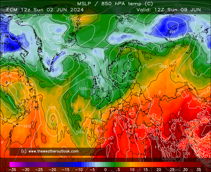
I'm afraid it's being a bit of a twit about things. Why's it so obsessed with high-latitude blocking at the moment? A world away from GFS and GEM (well, only until day 9 in the case of the latter... hmm).


Seems like a good time to focus on the short-mid range instead 


If you have any problems or queries relating to TWO you can Email [email protected] 🙂
https://twitter.com/peacockreports 
2021's Homeland Extremes:
T-Max: 30.4°C 21st Jul | T-Min: -6.8°C New Years Day! | Wettest Day: 34.1mm 2nd Oct | Ice Days: 2 (27th Jan & 8th Feb)
Keep Calm and Forecast On
Joe Bloggs
16 June 2017 18:54:24

One is not amused by the 12z ECM!


Pissing all over my Glastonbury parade in spectacular style. Boo! 


Manchester City Centre, 31m ASL

Solar Cycles
16 June 2017 19:05:54

Originally Posted by: Joe Bloggs 


One is not amused by the 12z ECM!


Pissing all over my Glastonbury parade in spectacular style. Boo! 


That's what Glastonbury is all about Joe, man up and get ya wellies out. 😂😂😂

Joe Bloggs
16 June 2017 19:07:43

Originally Posted by: Solar Cycles 


That's what Glastonbury is all about Joe, man up and get ya wellies out. 😂😂😂


I was there last year, and in 2013.


Trust me, the latter year was much more what it's all about. ;-) 


Manchester City Centre, 31m ASL

White Meadows
16 June 2017 21:50:42

Originally Posted by: LeedsLad123 


GFSP is supposed to correct that problem, but I'm not convinced:


GFS always seems to underestimate temperatures.


GFS does exactly the same in winter.


Silly minus 5's over the coast when the result stays above zero.


seen it a thousand times.

White Meadows
16 June 2017 21:53:34
And by the way...
If this is anything to go by, winter 2018 is over:
http://www.cpc.ncep.noaa.gov/products/CFSv2/imagesInd3/euT2mMonInd6.gif 
😂😂😂
Solar Cycles
16 June 2017 23:13:28

Originally Posted by: White Meadows 

And by the way...
If this is anything to go by, winter 2018 is over:
http://www.cpc.ncep.noaa.gov/products/CFSv2/imagesInd3/euT2mMonInd6.gif
😂😂😂

You know now even this far out that will be correct cometh the hour.😂😂😂

Bertwhistle
17 June 2017 06:00:40

GFS 06z offering a scorcher of a week in the south- high twenties until Friday and still warm next weekend.


http://www.theweatheroutlook.com/twodata/chart.aspx?chart=/charts/gfs/00_159_uk2mtmp.png?cb=547


Bertie, Itchen Valley.
'We'll never see 40 celsius in this country'.
Solar Cycles
17 June 2017 07:35:10
It's looking like several days of very warm conditions for England & Wales thereafter a return to near normal values but remaining predominantly dry, pleasant and warm in any sunshine.
Stormchaser
17 June 2017 07:57:34

The above may not prove accurate given the model shift this morning which has been toward letting more of that hot air in from the south during the period Tue-Fri, for example here is GFS adding three more days knocking on the door of 30*C with Wed still in the high 20s in parts of the SW:


Given the tendency to underestimate the maximums this is a startling turn from GFS after the sudden move toward a faster breakdown yesterday.


ECM and UKMO would rather peak the heat on Thursday, though;


Likely in the high 20s widely with 30*C possible in parts of the south, before a thundery breakdown into Friday. UKMO does however join GFS in having weak ridging from the Azores being influential enough to prevent a cool and unsettled weekend from following (GFS is in fact still in the mid-20s across the south but this does seem optimistic!).


ECM remains the 'demonic model' as it continues to dive the Atlantic jet south and to be honest I just don't get where it's getting such a prominent idea from. On day 8 it also puts an unprecedented (for June) 1960 mb low over the Arctic so it really is in a bad mood!


Funnily enough GEM was being even more aggressive with that Arctic storm but has now backed down, and is also permitting some impressive plume action for the UK with the heat lingering all the way out until Sunday across the SE'rn half of England;


So, lots of entertaining output around but the weather is so fine today that I will now put it all aside anyway  


If you have any problems or queries relating to TWO you can Email [email protected] 🙂
https://twitter.com/peacockreports 
2021's Homeland Extremes:
T-Max: 30.4°C 21st Jul | T-Min: -6.8°C New Years Day! | Wettest Day: 34.1mm 2nd Oct | Ice Days: 2 (27th Jan & 8th Feb)
Keep Calm and Forecast On
NickR
17 June 2017 08:58:32
Just give me a dry and not too cool Sunday 25 please!!!!!!
Nick
Durham
[email protected]
Bertwhistle
17 June 2017 09:03:30

http://www.theweatheroutlook.com/twodata/chart.aspx?chart=/charts/ecm/120_thickuk.png?cb=726


Now how often do you see the 564dam that widespread, so far north? This from the ECM.


Bertie, Itchen Valley.
'We'll never see 40 celsius in this country'.
Hungry Tiger
17 June 2017 09:42:06

Originally Posted by: Bertwhistle 


http://www.theweatheroutlook.com/twodata/chart.aspx?chart=/charts/ecm/120_thickuk.png?cb=726


Now how often do you see the 564dam that widespread, so far north? This from the ECM.


What sort of temperatures woould 564 dam air give.


Gavin S. FRmetS.
TWO Moderator.
Contact the TWO team - [email protected]
South Cambridgeshire. 93 metres or 302.25 feet ASL.


Quantum
17 June 2017 13:56:07

I don't like hot spells. Still one of the best things about them is we get to enjoy the NAVGEM comedy routine. Take it away!


Twitter: @QuantumOverlord (general), @MedicaneWatch (medicane/TC stuff)
2023/2024 Snow days (approx 850hpa temp):
29/11 (-6), 30/11 (-6), 02/12 (-5), 03/12 (-5), 04/12 (-3), 16/01 (-3), 18/01 (-8), 08/02 (-5)

Total: 8 days with snow/sleet falling.

2022/2023 Snow days (approx 850hpa temp):

18/12 (-1), 06/03 (-6), 08/03 (-8), 09/03 (-6), 10/03 (-8), 11/03 (-5), 14/03 (-6)

Total: 7 days with snow/sleet falling.

2021/2022 Snow days (approx 850hpa temp):

26/11 (-5), 27/11 (-7), 28/11 (-6), 02/12 (-6), 06/01 (-5), 07/01 (-6), 06/02 (-5), 19/02 (-5), 24/02 (-7), 30/03 (-7), 31/03 (-8), 01/04 (-8)
Total: 12 days with snow/sleet falling.
PFCSCOTTY
17 June 2017 15:04:20
Funny Summer was over on this forum only a week ago!
Caz
  • Caz
  • Advanced Member
17 June 2017 16:14:58

Originally Posted by: Solar Cycles 

It's looking like several days of very warm conditions for England & Wales thereafter a return to near normal values but remaining predominantly dry, pleasant and warm in any sunshine.

Mum's funeral is Wednesday, not Thursday as per my previous post. What's it looking like for here?  Hope it's not too unbearable for your hospital stay either. 


Market Warsop, North Nottinghamshire.
Join the fun and banter of the monthly CET competition.
TimS
  • TimS
  • Advanced Member
17 June 2017 16:37:03
GFS 12z teases with a reload late next week then frustratingly gets frozen at 129 hrs.
Brockley, South East London 30m asl
Solar Cycles
17 June 2017 16:51:32

Originally Posted by: Caz 


Mum's funeral is Wednesday, not Thursday as per my previous post. What's it looking like for here?  Hope it's not too unbearable for your hospital stay either. 


I'll be down at Nottingham City hospital for the duration so no doubt it will be much warmer down there. Hope all goes well ( as well as can be expected ) for you Caz on Wednesday, take care. 

Users browsing this topic

Ads