blaggers1968
Sunday, May 21, 2017 6:45:58 PM

Originally Posted by: briggsy6 


Amazing that three separate locations all recorded identical maximum temps on the same day back in May 1944!


it's because they used to round off to the nearest degree Fahrenheit then, and 91F was the max quoted which converts to 32.8C.

idj20
Monday, May 22, 2017 7:11:43 AM

From what I'm seeing, the models appears to be going off the idea of 80 F being reached later on this week, also the thundery stuff for the weekend seems to be watered down slightly.

But nonetheless it'll still be very pleasantly warm, dry and bright enough for the rest of the week what with high pressure never being far away, that's good enough for me considering we are still only in May.


Folkestone Harbour. 
DEW
  • DEW
  • Advanced Member
Monday, May 22, 2017 8:27:53 AM

Originally Posted by: idj20 


From what I'm seeing, the models appears to be going off the idea of 80 F being reached later on this week, also the thundery stuff for the weekend seems to be watered down slightly.

But nonetheless it'll still be very pleasantly warm, dry and bright enough for the rest of the week what with high pressure never being far away, that's good enough for me considering we are still only in May.


Indeed, upper 70s are excellent for combining a bit of activity with a bit of sunning yourself.


Thundery stuff does appear to ahve been put off; there's a hint of it at long range in the second week http://www.wxmaps.org/pix/prec4.html and backed up by the latest available GFS.


War does not determine who is right, only who is left - Bertrand Russell

Chichester 12m asl
Arcus
Monday, May 22, 2017 9:27:02 AM

Originally Posted by: idj20 


From what I'm seeing, the models appears to be going off the idea of 80 F being reached later on this week, also the thundery stuff for the weekend seems to be watered down slightly.

But nonetheless it'll still be very pleasantly warm, dry and bright enough for the rest of the week what with high pressure never being far away, that's good enough for me considering we are still only in May.


The outlook for the weekend will doubtless chop and change as the models get a handle on the influence of low pressure to the west and the runner low from the south that some models are dropping. ECM keeps with it though, and this chart is potentially quite potent for storms, particularly in western areas:


Ben,
Nr. Easingwold, North Yorkshire
30m asl
Hungry Tiger
Monday, May 22, 2017 1:54:36 PM

Originally Posted by: Arcus 


The outlook for the weekend will doubtless chop and change as the models get a handle on the influence of low pressure to the west and the runner low from the south that some models are dropping. ECM keeps with it though, and this chart is potentially quite potent for storms, particularly in western areas:


Keep us all up to date wrt to hot weather this coming weekend.


Gavin S. FRmetS.
TWO Moderator.
Contact the TWO team - [email protected]
South Cambridgeshire. 93 metres or 302.25 feet ASL.


Phil G
Monday, May 22, 2017 3:10:33 PM

Originally Posted by: idj20 


From what I'm seeing, the models appears to be going off the idea of 80 F being reached later on this week, also the thundery stuff for the weekend seems to be watered down slightly.

But nonetheless it'll still be very pleasantly warm, dry and bright enough for the rest of the week what with high pressure never being far away, that's good enough for me considering we are still only in May.


The BBC were touting 30c as we go into the weekend. I agree with you, it will feel good without the terrific heat.

Stormchaser
Monday, May 22, 2017 6:34:10 PM


For me this is becoming one of the most fascinating periods of summertime model watching (well, the computer variant) that I can remember. That low near the Azores has become more of a player since yesterday's runs, with recent GFS and UKMO runs suggesting it will drop down west of Iberia and bring about two significant results;


  1. The plume of heat and moisture gets drawn further west before it can really engage much with the shallow low drifting N through the UK.

  2. The stage is set for a strong ridge to build across to the north of the dropping low and then right through the UK by Mon or Tue next week.


...but ECM keeps on having other ideas and this evening's 12z is no exception!


While it's true that GFS on the left has slowed down the removal of the warm air through Sunday, it can't compare with ECM's exploratory tendencies as it now lifts the shallow low out west of the UK while making the one by Iberia so weak as to have little effect on the plume.


This is a more exciting outcome in terms of heat and thunderstorm potential , but I do worry that the low by the UK is now close enough to the Atlantic jet stream that it might open the door to the Atlantic troughs over the following couple of days! 


If you have any problems or queries relating to TWO you can Email [email protected]

https://twitter.com/peacockreports 
2023's Homeland Extremes:
T-Max: 30.2°C 9th Sep (...!) | T-Min: -7.1°C 22nd & 23rd Jan | Wettest Day: 25.9mm 2nd Nov | Ice Days: 1 (2nd Dec -1.3°C in freezing fog)
Keep Calm and Forecast On
sizzle
Monday, May 22, 2017 6:51:21 PM

always a fantastic detailed post from stormchaser, thanks, also when will TWO be issuing there summer forecast ???

Hungry Tiger
Monday, May 22, 2017 6:51:44 PM

Originally Posted by: Stormchaser 


For me this is becoming one of the most fascinating periods of summertime model watching (well, the computer variant) that I can remember. That low near the Azores has become more of a player since yesterday's runs, with recent GFS and UKMO runs suggesting it will drop down west of Iberia and bring about two significant results;


  1. The plume of heat and moisture gets drawn further west before it can really engage much with the shallow low drifting N through the UK.

  2. The stage is set for a strong ridge to build across to the north of the dropping low and then right through the UK by Mon or Tue next week.


...but ECM keeps on having other ideas and this evening's 12z is no exception!
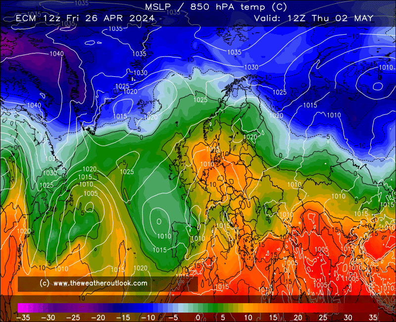


While it's true that GFS on the left has slowed down the removal of the warm air through Sunday, it can't compare with ECM's exploratory tendencies as it now lifts the shallow low out west of the UK while making the one by Iberia so weak as to have little effect on the plume.


This is a more exciting outcome in terms of heat and thunderstorm potential , but I do worry that the low by the UK is now close enough to the Atlantic jet stream that it might open the door to the Atlantic troughs over the following couple of days! 


Great post - we don't want this to end up as a one heat wonder leading to a bad summer. That's always a worry this early in the season.


Gavin S. FRmetS.
TWO Moderator.
Contact the TWO team - [email protected]
South Cambridgeshire. 93 metres or 302.25 feet ASL.


Stormchaser
Monday, May 22, 2017 6:52:45 PM


Well, I'm very pleased to be wrong about the Atlantic trough 


Amazing run from ECM when you think about it; one of the hottest Spring Bank Holidays on record may be achievable although 32.8*C seems a bit of a stretch for the highest maximum.


If you have any problems or queries relating to TWO you can Email [email protected]

https://twitter.com/peacockreports 
2023's Homeland Extremes:
T-Max: 30.2°C 9th Sep (...!) | T-Min: -7.1°C 22nd & 23rd Jan | Wettest Day: 25.9mm 2nd Nov | Ice Days: 1 (2nd Dec -1.3°C in freezing fog)
Keep Calm and Forecast On
Hungry Tiger
Monday, May 22, 2017 6:56:40 PM

Originally Posted by: Stormchaser 


Well, I'm very pleased to be wrong about the Atlantic trough 


Amazing run from ECM when you think about it; one of the hottest Spring Bank Holidays on record may be achievable although 32.8*C seems a bit of a stretch for the highest maximum.


Cheers James - Great stuff.


Gavin S. FRmetS.
TWO Moderator.
Contact the TWO team - [email protected]
South Cambridgeshire. 93 metres or 302.25 feet ASL.


Hungry Tiger
Monday, May 22, 2017 6:58:30 PM

One good indication that we are going to get something good this year was Tenerife getting 34.5C in early March. Shows that the Azores high has got some oomph in it.


Gavin S. FRmetS.
TWO Moderator.
Contact the TWO team - [email protected]
South Cambridgeshire. 93 metres or 302.25 feet ASL.


Bertwhistle
Monday, May 22, 2017 8:45:42 PM

Love that GEM: this at 1200 would lead to serious ht at say 3pm:


http://www.theweatheroutlook.com/twodata/chart.aspx?chart=/charts/gem/240_uk2mtmp.png?cb=69


Bertie, Itchen Valley.
'We'll never see 40 celsius in this country'.
Whether Idle
Monday, May 22, 2017 9:31:04 PM

Sunday has the potential for very warm uppers.  ECM 144:


Dover, 5m asl. Half a mile from the south coast.
cultman1
Tuesday, May 23, 2017 1:17:35 PM
Are there signs of a significant downgrade for the bank holiday weekend weather countrywide?
haghir22
Tuesday, May 23, 2017 1:53:30 PM

Originally Posted by: cultman1 

Are there signs of a significant downgrade for the bank holiday weekend weather countrywide?


Not on the latest Beeb forecast I saw?


YNWA
Rob K
Tuesday, May 23, 2017 4:19:14 PM

Originally Posted by: cultman1 

Are there signs of a significant downgrade for the bank holiday weekend weather countrywide?


Not really. Warm and sticky and with an increasing chance of thunderstorms through the weekend, sums it up (for southern England anyway).


Yateley, NE Hampshire, 73m asl
"But who wants to be foretold the weather? It is bad enough when it comes, without our having the misery of knowing about it beforehand." — Jerome K. Jerome
SJV
  • SJV
  • Advanced Member
Tuesday, May 23, 2017 4:24:32 PM

Originally Posted by: cultman1 

Are there signs of a significant downgrade for the bank holiday weekend weather countrywide?


Short answer: No.


Long answer: F*** no.


Follow/like Steel City Skies - Sheffield Weather Forecasting on Facebook , Twitter  and Instagram .
📢 Play the TWO Forums Quiz!  📢
Charmhills
Tuesday, May 23, 2017 5:12:36 PM

Originally Posted by: Rob K 


Not really. Warm and sticky and with an increasing chance of thunderstorms through the weekend, sums it up (for southern England anyway).


Indeed, goodies for convective fans alike.


Loughborough, EM.

Knowledge is power, ignorance is weakness.

Duane.
Sinky1970
Tuesday, May 23, 2017 5:28:28 PM
Let's hope eh.
Users browsing this topic

Ads