moomin75
07 December 2018 17:32:58
January will IMO buck the trend of recent January's and cone out with a below average, possibly well below average CET. I expect it will be quite dry but all areas will see at least some snow.
Make the most of this mild December because I foresee a severe January ahead.
Witney, Oxfordshire
100m ASL
JACKO4EVER
07 December 2018 18:40:19
Guys let’s get away from Ian bashing, actually what he has said on this thread is reasoned and quite factual.
In the meantime some interest for coldies, it’s all up in the air again as is usual with most UK cold spells/ snaps
doctormog
07 December 2018 18:51:34
http://www.wetterzentrale.de/maps/ECMOPEU12_192_1.png  The outcome could be mild and mobile but it could very well be something much more interesting. I could of course ignore all that and bet on the UK default climate pattern, but that doesn’t need any analysis.
Chunky Pea
07 December 2018 18:55:52

I always find it frustrating that anytime a half decent storm low develops in the Atlantic, a half assed block always sets up in just the right position to push it off course. A block that will bring nothing of interest in itself, but just strong enough to steer anything of interest from the Atlantic away. 


http://www.wetterzentrale.de/maps/ECMOPEU12_120_1.png


Sigh. 


Current Conditions
https://t.ly/MEYqg 


"You don't have to know anything to have an opinion"
--Roger P, 12/Oct/2022
Polar Low
07 December 2018 19:35:42

Yes and only a  fool would predict ukmo t144 outcome


Modele UKMO - Carte prévisions


http://www.wetterzentrale.de/maps/ECMOPEU12_192_1.png  The outcome could be mild and mobile but it could very well be something much more interesting. I could of course ignore all that and bet on the UK default climate pattern, but that doesn’t need any analysis.

Steve Murr
07 December 2018 19:47:21

Originally Posted by: Polar Low 


Yes and only a  fool would predict ukmo t144 outcome


The Energy transfer SE has been the preferred / forecast option all week - its just the models have continued with their zonal bias -


Now finally under the magical 144 mark we are seeing the jet bend away from the UK from the scandi high - A classic winter influence-


ECM brings snow to many as does the UKMO however at this early stage & with ~ 540 thicknesses then its all a bit marginal but with scope for improvements- Ideally in the form of a bit more 'continental feed' underneath... SE is much much better than SSE in this scenario...


S

Phil G
07 December 2018 19:50:02

Seems there are a succession of Atlantic storms lined up for next week, but not sure which one or two have our name firmly on them.
Could be headline makers in there, certainly the coasts will take a battering with coastal erosion and over topping.

picturesareme
07 December 2018 19:56:49

Originally Posted by: moomin75 

January will IMO buck the trend of recent January's and cone out with a below average, possibly well below average CET. I expect it will be quite dry but all areas will see at least some snow.
Make the most of this mild December because I foresee a severe January ahead.


Screen shot this ^^^^ 


Come mid January when we're still enduring Atlantic system after system, rivers are beginning to burst, and the best cold has been a few frosty night's inbetween, I bet you'll be bragging about how you had predicted this all weeks or months earlier 🤣😋

Polar Low
07 December 2018 20:08:20

That would be good enough for most Steve as we all know we dont need massive -ve 850s in s/e feed its happened before we just need more of them to grow.


Originally Posted by: Steve Murr 


The Energy transfer SE has been the preferred / forecast option all week - its just the models have continued with their zonal bias -


Now finally under the magical 144 mark we are seeing the jet bend away from the UK from the scandi high - A classic winter influence-


ECM brings snow to many as does the UKMO however at this early stage & with ~ 540 thicknesses then its all a bit marginal but with scope for improvements- Ideally in the form of a bit more 'continental feed' underneath... SE is much much better than SSE in this scenario...


S


moomin75
07 December 2018 20:12:49

Originally Posted by: picturesareme 


Screen shot this ^^^^ 


Come mid January when we're still enduring Atlantic system after system, rivers are beginning to burst, and the best cold has been a few frosty night's inbetween, I bet you'll be bragging about how you had predicted this all weeks or months earlier 🤣😋


Happy for this to be screenshotted. In fact I will if you like. If I'm wrong I'm wrong, but I think we will all be pleasantly surprised in January. I am very confident of a very mild December and have been for weeks. January altogether a different prospect.


Witney, Oxfordshire
100m ASL
johncs2016
07 December 2018 20:20:17

The chart below shows the rainfall pattern for the next 10 days across the UK, and shows how wet it is generally expected to be.
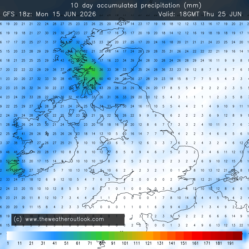


However, you will probably have noticed in that map that the driest area appears to in SE Scotland once again.


One thing which I have kept on mentioning in both the Current Conditions thread and the Precipitation Watch Thread is the manner in we are just not getting as much rain here in this part of the world just now as what the rest of the UK appears to be getting according to what everyone else is reporting on those threads, even though we are getting more rain than what we have been getting for a while. The above chart shows clearly, how this is likely to be the case for the next 10 days as well, resulting in that rainfall gap between here and the rest of the UK getting even bigger over that time.


Yet we in this part of the world have one of the biggest rainfall deficits in the UK to have built up over the course of the year. Last month was wetter than average here, though not by much and whilst the rest of the UK is running much wetter than average just now, our rainfall totals during this month so far are running at no more than average. This means that whilst the rainfall deficit may well be getting made up in the rest of the UK, that just isn't happening here in SE Scotland, and doesn't look like happening during the next 10 days either, going by the above chart.


I therefore find it weird that mother nature appears to be picking on this area of the UK in particular, for not giving us as much rainfall as the rest of the UK although I'm sure than anyone who is more knowledgeable than me, will be able to give a very good reason for why this is the case.


The north of Edinburgh, usually always missing out on snow events which occur not just within the rest of Scotland or the UK, but also within the rest of Edinburgh.
Shropshire
07 December 2018 21:13:04

Have to say I'm shocked at some of the posts on the other side about a possible snow event towards the end of next week. Two golden rules for this to  happen (away from the highest ground ) -


  • cold air has to be in place first before the PPN arrives

  • if it isn't then colder air has to be pushing back against the PPN to turn it to snow


Whatever the wind direction, none of the models show the above happening.


From December 27th 2020, zonality will be banned from mixing with the UK. We appreciate that this may come as a shock to younger people and old Uncle Barty. This ban will last for a minimum of ten days.
doctormog
07 December 2018 21:21:51

Originally Posted by: Shropshire 


Have to say I'm shocked at some of the posts on the other side about a possible snow event towards the end of next week. Two golden rules for this to  happen (away from the highest ground ) -


  • cold air has to be in place first before the PPN arrives

  • if it isn't then colder air has to be pushing back against the PPN to turn it to snow


Whatever the wind direction, none of the models show the above happening.


None of the models? 


https://weather.us/model-charts/euro/great-britain/snow-depth/20181215-0600z.html 


squish
07 December 2018 21:22:37

Originally Posted by: Shropshire 


Have to say I'm shocked at some of the posts on the other side about a possible snow event towards the end of next week. Two golden rules for this to  happen (away from the highest ground ) -


  • cold air has to be in place first before the PPN arrives

  • if it isn't then colder air has to be pushing back against the PPN to turn it to snow


Whatever the wind direction, none of the models show the above happening.


 You’ve been in the game long enough to know the big 3 +144 charts are as enticing as they come for the UK. Atlantic is always odds on but at +6 days any adjustment west would bring a snow event. ECM also holds the block to the NE as the Atlantic fizzles....


D.E.W on Dartmoor. 300m asl
JMM2005
07 December 2018 21:41:28

Originally Posted by: johncs2016 


The chart below shows the rainfall pattern for the next 10 days across the UK, and shows how wet it is generally expected to be.


However, you will probably have noticed in that map that the driest area appears to in SE Scotland once again.


One thing which I have kept on mentioning in both the Current Conditions thread and the Precipitation Watch Thread is the manner in we are just not getting as much rain here in this part of the world just now as what the rest of the UK appears to be getting according to what everyone else is reporting on those threads, even though we are getting more rain than what we have been getting for a while. The above chart shows clearly, how this is likely to be the case for the next 10 days as well, resulting in that rainfall gap between here and the rest of the UK getting even bigger over that time.


Yet we in this part of the world have one of the biggest rainfall deficits in the UK to have built up over the course of the year. Last month was wetter than average here, though not by much and whilst the rest of the UK is running much wetter than average just now, our rainfall totals during this month so far are running at no more than average. This means that whilst the rainfall deficit may well be getting made up in the rest of the UK, that just isn't happening here in SE Scotland, and doesn't look like happening during the next 10 days either, going by the above chart.


I therefore find it weird that mother nature appears to be picking on this area of the UK in particular, for not giving us as much rainfall as the rest of the UK although I'm sure than anyone who is more knowledgeable than me, will be able to give a very good reason for why this is the case.


1-4 inches of rain during a wet period of winter over 10 days should not really unexpected to be honest


Justin
Brighton seafront
Webcam of the beach and Brighton's palace pier
https://www.skylinewebcams.com/en/webcam/united-kingdom/england/brighton/brighton-pier.html 
doctormog
07 December 2018 21:50:18
I wonder if the GFS 18z op run will follow the snowy scenario for the end of next weeek for many shown on the 12z ECM op run?
JMM2005
07 December 2018 21:52:39
This winter will twist and turn we have all heard the buzz and dreamed of the hopeful expectation of a noteworthy cold one. Something is up that for sure but what and how it will manifest its self is unclear whether it’s SSW or some other driver let’s not all take it too seriously let watch learn and observe. Weather has happened on this planet for over 4 billion years and we only reliably know the day to day detail for anywhere on this planet in our small country let alone globally for about 300 years so let’s get stuff in perspective here. Will will watch, hope, hope-cast, dream and get disappointed on this forum and any other more time than watching our favourite team play any sport. So let watch express our thoughts , hopes and disappointments together and enjoy the fact we live in a country that let be honest, generally delivers 48 weeks of October weather 2 weeks of January and 2 weeks of July at best and every thing else is a bonus. And on that basis this year we have had some good bonuses already.
Justin
Brighton seafront
Webcam of the beach and Brighton's palace pier
https://www.skylinewebcams.com/en/webcam/united-kingdom/england/brighton/brighton-pier.html 
Stolen Snowman
07 December 2018 22:19:20

Originally Posted by: JMM2005 

This winter will twist and turn we have all heard the buzz and dreamed of the hopeful expectation of a noteworthy cold one. Something is up that for sure but what and how it will manifest its self is unclear whether it’s SSW or some other driver let’s not all take it too seriously let watch learn and observe. Weather has happened on this planet for over 4 billion years and we only reliably know the day to day detail for anywhere on this planet in our small country let alone globally for about 300 years so let’s get stuff in perspective here. Will will watch, hope, hope-cast, dream and get disappointed on this forum and any other more time than watching our favourite team play any sport. So let watch express our thoughts , hopes and disappointments together and enjoy the fact we live in a country that let be honest, generally delivers 48 weeks of October weather 2 weeks of January and 2 weeks of July at best and every thing else is a bonus. And on that basis this year we have had some good bonuses already.


There certainly is lots of interest in the models this winter so far and long may it continue. After all, isn’t that part of the fun?


Statistics prove that the period just after records began witnessed some of the most extreme weather ever recorded. Records were being broken on a frequency that has not been repeated since.
Posting live from a pub somewhere in Burton upon Trent
Steve Murr
07 December 2018 22:22:12

Originally Posted by: Polar Low 


That would be good enough for most Steve as we all know we dont need massive -ve 850s in s/e feed its happened before we just need more of them to grow.


indeed - The 18z has again moved to the Euro solution ( which ive highlighted on the other side ) 


Fun times ahead....

Brian Gaze
07 December 2018 22:51:10


Brian Gaze
Berkhamsted
TWO Buzz - get the latest news and views 
"I'm not socialist, I know that. I don't believe in sharing my money." - Gary Numan
Users browsing this topic

Ads