If the ECM 12z isn't worth some fresh analysis from me here, I don't know what is, so here goes...
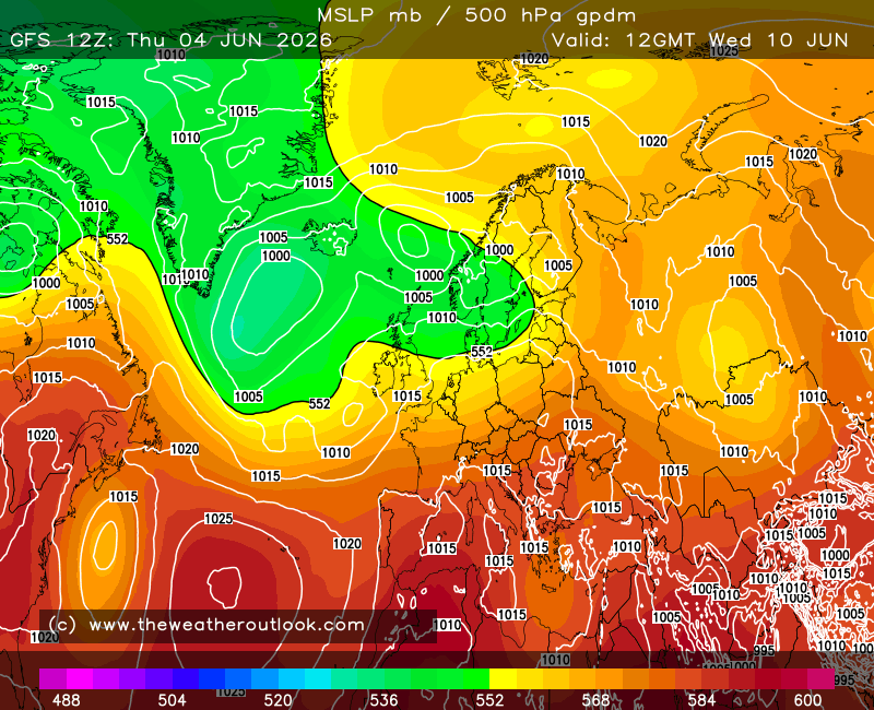
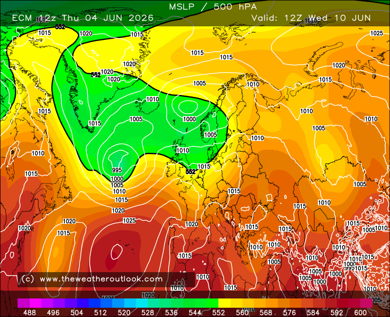
Right. Day 6, when ECM is usually king of the hill but not without some hiccups. We see that GFS (left) has a trough by Iceland with the deepest - near 985 mb - portion located between that island and Greenland. Meanwhile ECM (right), while also having a trough by Iceland, has the focal point a little east of GFS but shallower at near 990 mb, while on the western flank there is a small secondary low.
Looking at the 12z UKMO and JMA runs, they both bare more resemblance to ECM than GFS, but while the secondary low is there, it's weaker and less well defined.
Another important feature to consider is the low by the East U.S. Coast. GFS has this further NE than ECM, while JMA is similar to ECM and UKMO has the low even further SW and weaker too.
Now let's jump two days forward...
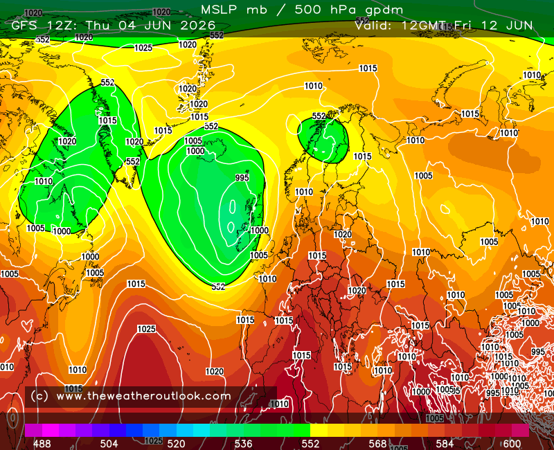
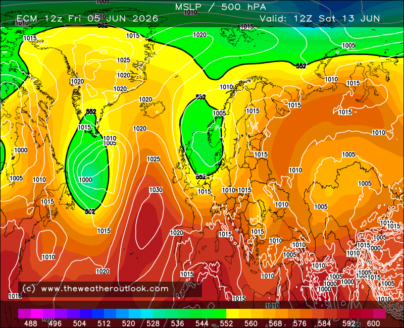
Well then. GFS' lack of secondary low has allowed the main trough to advance east without much trouble, while the faster low off the East U.S. Coast has managed to push through ahead of a ridge build taking place in the far-western N. Atlantic. By contrast, ECM's has the secondary low causing the trough to elongate on the SW flank and interact with the shallow low visible near the Azores back at +144 hours, while the slower low by the U.S. has become trapped behind the far-W. Atlantic ridge build (which in turn has been shunted a little east as the low hit the buffers).
Now I can't clearly tell whether UKMO is set to have that interaction with the Azores low as a result of the secondary low on the western flank of the trough by Iceland, but I certainly see that JMA is, because the chart is right there for the admiration;

That's a strong vote for ECM having the right idea here, but as ever, we can't rule out the underdog GFS even at +6 days range.
Interestingly enough, yesterday's JMA 12z was similar to this morning's ECM 00z. So the two models seem to be moving in tandem.
It's fair to say that GFS has moved quite a bit toward ECM today too, with increased heights to the east in the 12z run for early-mid next week relative to the 00z, for example, so there's a lot of momentum in the trends here - but it's one that's still fresh enough to merit caution.
Now, I think it's only just if I post that ECM day 10 N. Hem perspective in large format to round this off;
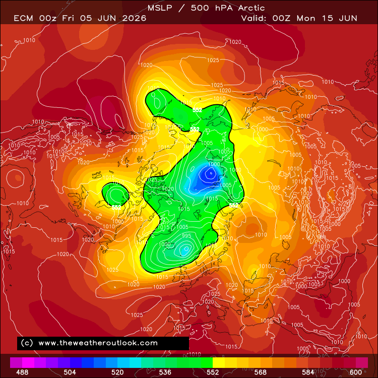
- and yes, that really is a December 2010 style situation. A few other major examples also spring to mind - which I expect some of you on here can figure out 
 .
.
If you have any problems or queries relating to TWO you can Email
[email protected] 🙂
https://twitter.com/peacockreports 2021's Homeland Extremes:
T-Max: 30.4°C 21st Jul | T-Min: -6.8°C New Years Day! | Wettest Day: 34.1mm 2nd Oct | Ice Days: 2 (27th Jan & 8th Feb)
Keep Calm and Forecast On