The Weather Outlook

Remove ads from site

Steve Murr
08 December 2018 12:13:45


  - flooding becoming an issue if this run comes off, a really dreadful pattern and as shown on the ECM, signs of a West based NAO with pressure rising over Europe by day 10.


Originally Posted by: Shropshire 

Even the lowly NAVGEM 06z & JMA (84 06z ) are now falling towards the Euros with a closed off shallow low sliding SE forcing more CAA west out of the continent-

Its just the useless ( in this scenario ) GFS that cannot work it out-

As mentioned on NW - tomorrow 12z or Monday 00z GFS may finally have cottoned on...

nsrobins
08 December 2018 12:17:12
Well Steve we’ll know by Weds at the latest if a transient snow event is on not.

Tally - you can’t have a SSW until after the event whatever is forecast.


Neil

Fareham, Hampshire 28m ASL (near estuary)

Stormchaser, Member TORRO

tallyho_83
08 December 2018 12:54:28

Well Steve we’ll know by Weds at the latest if a transient snow event is on not.
Tally - you can’t have a SSW until after the event whatever is forecast.

Originally Posted by: nsrobins 

Sorry what event?


Home Location - Vixen Tor Close, Okehampton, Devon (221m ASL)

---------------------------------------

Sean Moon

Magical Moon

www.magical-moon.com

doctormog
08 December 2018 13:02:48


Sorry what event?

Originally Posted by: tallyho_83 

The one that causes the SSW (which is as yet not shown in the output)


roadrunnerajn
08 December 2018 13:13:51

Whilst there is nothing noteworthy of any cold coming - keep an eye out over the Stratosphere from the Siberian Side:

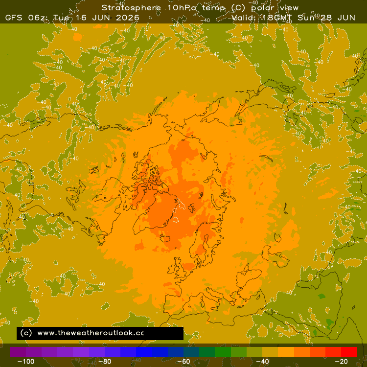
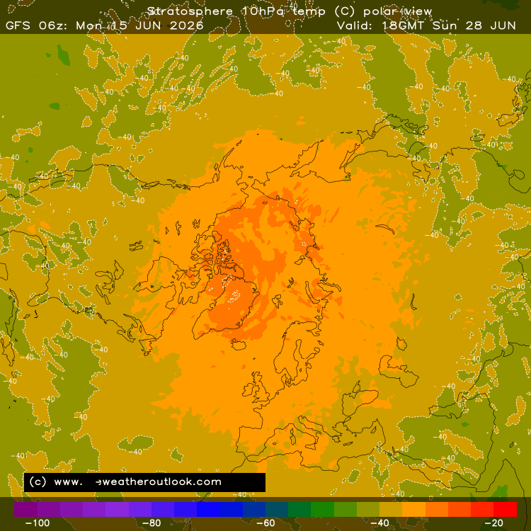
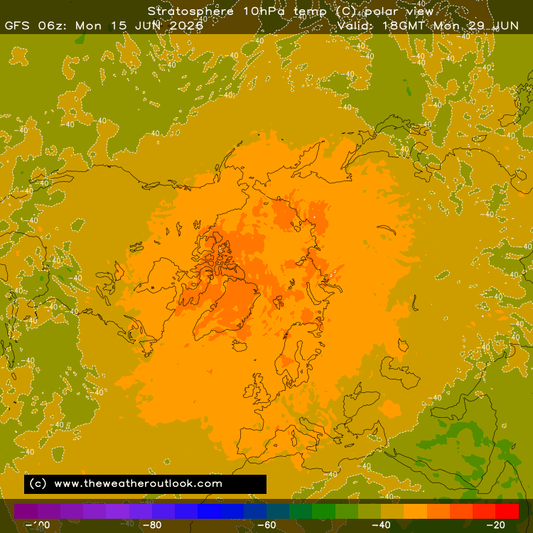
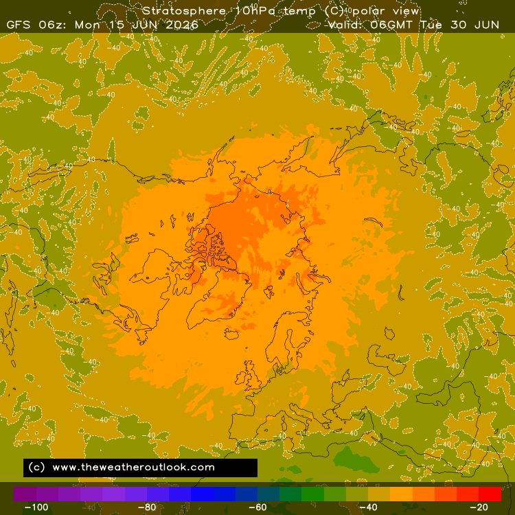
We eventually push the oranges and red's into the Arctic region and onto the n. Pole now. This has been quite consistent. It's a long way off and of course can change but it does fit into a potential cold blocked start to January if this comes off and the HP block sets up right over Scandinavia  2-3 weeks down the line. During the last major SSW it was 15 days until we saw beast from the east. The warming was around 9th - 12th Feb 2018 and the easterly hit us from 25th Feb 2018. 

So if this comes off between 19th and 21st December then we are looking at a much colder or fingers crossed). - Bitterly cold 1st/2nd week of January 2019. Fingers crossed but all depends on the blocking and where the HP sits.

This major SSW is forming from the same side of the Arctic and into the N. Pole similar to the warming last time - so many the block will be in same position or does it depend. Another question...i wanted to ask?

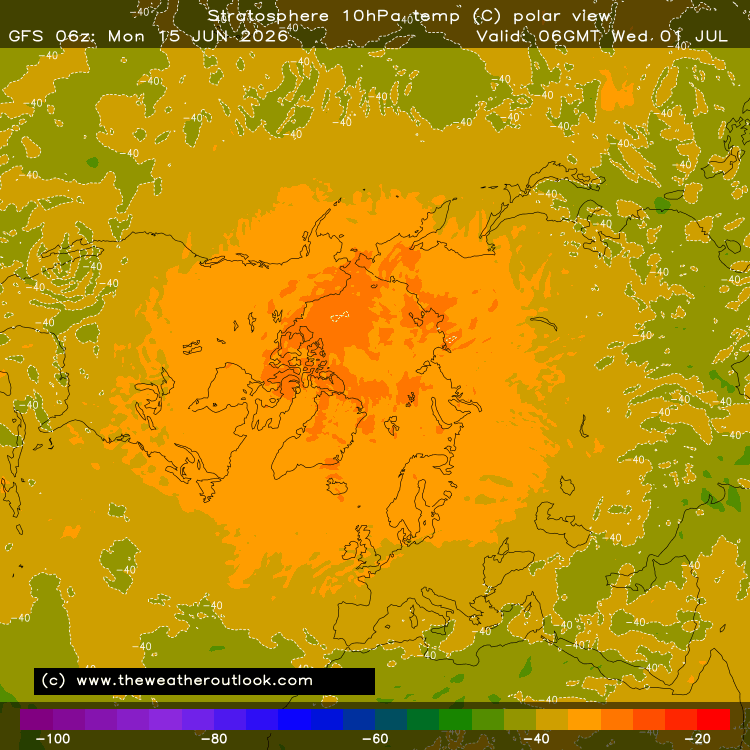
Has there ever been a case where a SSW has been so great that it's got above -5c in stratosphere? The temperatures look like they are off the scale here on this model output? Have we ever seen 0c or +5c before in strat over Arctic? and is it the case that the more significant the SSW/ MORE WARMER it is the bigger and more extensive the blocking? anyone?

Originally Posted by: tallyho_83 

I'm pretty sure I've seen the same charts above show above zero temperatures in the past. I believe I saw this several years ago. Maybe someone on here will be a little more precise. ( I saw this in FI not in actual time)


Germoe, part of the breakaway Celtic Republic. 80m asl
nsrobins
08 December 2018 15:15:49
12Z ICON manages another adjustment West with the Scandy heights which results in a 150mile jog west for the boundary line at 105hrs

Not saying it will result in anything other than the inevitable Atlantic intrusion by Thursday but it’s still noteworthy.


Neil

Fareham, Hampshire 28m ASL (near estuary)

Stormchaser, Member TORRO

Gooner
08 December 2018 16:01:01

Very mild and wet next Saturday morning on the GFS -


http://old.wetterzentrale.de/pics/Rtavn1681.gif


Originally Posted by: Shropshire 

Blink and you miss it though 


Remember anything after T120 is really Just For Fun


Marcus

Banbury

North Oxfordshire

378 feet A S L


Brian Gaze
08 December 2018 16:39:05

GFS12z disrupts things more next week although the Atlantic still gets in eventually. The CMC 12z run is also interesting and suggests a period of snow late next week as the Atlantic returns. 

https://www.theweatheroutlook.com/twodata/gem.aspx?run=12&charthour=156&chartname=ukpreciptyperatec&chartregion=uk&charttag=Precip%20type%20rate

PS: I'll be having a pint of Festive Foxtrot tonight, so won't be posting but will be browsing. It means that if I see OT posts I am likely to get an itchy finger and vaporise the account of the poster. As you know by now, once you're account is gone, it is gone! So let's see if we can do better than last night's rubbish. The season of goodwill isn't here just yet. 


Brian Gaze

Berkhamsted

TWO Buzz - get the latest news and views 

"I'm not socialist, I know that. I don't believe in sharing my money." - Gary Numan

doctormog
08 December 2018 16:46:11
By day 10 the 12z GFS op run is totally different to the 06z op which just highlights the uncertainty of the last few days in the week to ten day range. I would hope for a bit more consistency from the ECM later however we haven’t really got that from the UKMO.
Chunky Pea
08 December 2018 16:56:29

Time & time over the GFS gets it wrong...

S

Originally Posted by: Steve Murr 

No, it doesn't.

Wasn't it the GFS which first showed a greater Atlantic influence? And, if I remember correctly, it was the GFS which first picked up on the recent easterly spell.

I don't understand all this hating on the GFS when it doesn't show what we want.


Patrick,

East Galway, Ireland.

tallyho_83
08 December 2018 17:11:39

Here it comes: - Look what's happening over Siberia!

Jump of some 40c in the stratosphere in space of 3 days.

Can't find chart for 30hpa but this is @ 10hpa: - based on 12z run.

Ties in well with strength of zonal westerlies @ 60'N. - Definite weakening end of December into January! 


Home Location - Vixen Tor Close, Okehampton, Devon (221m ASL)

---------------------------------------

Sean Moon

Magical Moon

www.magical-moon.com

Steve Murr
08 December 2018 18:16:52
Great ECM tonight at 96

-6c into the SE corner- best of the bunch...

Solar Cycles
08 December 2018 18:35:19

GFS12z disrupts things more next week although the Atlantic still gets in eventually. The CMC 12z run is also interesting and suggests a period of snow late next week as the Atlantic returns. 

https://www.theweatheroutlook.com/twodata/gem.aspx?run=12&charthour=156&chartname=ukpreciptyperatec&chartregion=uk&charttag=Precip%20type%20rate

PS: I'll be having a pint of Festive Foxtrot tonight, so won't be posting but will be browsing. It means that if I see OT posts I am likely to get an itchy finger and vaporise the account of the poster. As you know by now, once you're account is gone, it is gone! So let's see if we can do better than last night's rubbish. The season of goodwill isn't here just yet. 


Originally Posted by: Brian Gaze 

Looking like Steve’s call earlier in the week for next Thursday could be right. 😎

Gavin D
08 December 2018 18:59:13

David M Porter
08 December 2018 19:22:45

Originally Posted by: Gavin D 

Hmmm, I wonder if Matt is dropping some hints?


Lenzie, Glasgow

"A body of men holding themselves accountable to nobody ought not to be trusted by anybody." – Thomas Paine

jhall
08 December 2018 19:28:57

Here it comes: - Look what's happening over Siberia!

Jump of some 40c in the stratosphere in space of 3 days.

<big snip>

Originally Posted by: tallyho_83 

Remember that even the earliest of the charts that you've posted is for 13 days hence. Are forecasts for the stratosphere at that range any more to be relied on than the forecast charts for lower levels that we obsess over? Though the stratosphere affects developments at lower levels, surely the converse must also be true, making forecasting changes in the stratosphere difficult. 


Cranleigh, Surrey
Gandalf The White
08 December 2018 20:01:44


No, it doesn't.

Wasn't it the GFS which first showed a greater Atlantic influence? And, if I remember correctly, it was the GFS which first picked up on the recent easterly spell.

I don't understand all this hating on the GFS when it doesn't show what we want.

Originally Posted by: Chunky Pea 

When you decide to quote just part of a post out of context I think it devalues your criticism.  Steve was referring to the modelling of the ingress of milder air into the country next week.  It is fair to say that most of the models can struggle with something finely balanced, particularly when they're global models and we're all focusing on a couple of hundred miles - which is obviously insignificant in global terms.

GFS has been pulling back from its original forecast of the jetstream taking control over the British Isles.  I think it is inevitable but the timing is still up in the air. 


Location: South Cambridgeshire

130 metres ASL

52.0N 0.1E


Maunder Minimum
08 December 2018 20:07:02

Anyhow, when it comes to the Strat, there is still something stirring around 16/17 Dec:

[Temperatures at the North Pole and in 60°N]


New world order coming.
Shropshire
08 December 2018 20:09:52

Originally Posted by: Gavin D 

Certainly agree with his assessment of next week, let's hope for the pattern flip that he is alluding to there.


From December 27th 2020, zonality will be banned from mixing with the UK. We appreciate that this may come as a shock to younger people and old Uncle Barty. This ban will last for a minimum of ten days.
doctormog
08 December 2018 20:15:20
Good consistency re. the snow risk once again on the ECM. A subtle shift in that direction on the GFS and a snowy scenario on the GEM. Still a fascinating a finely balanced situation and certainly worth watching as nothing is settled for next week.
Arcus
08 December 2018 20:21:48

Good consistency re. the snow risk once again on the ECM. A subtle shift in that direction on the GFS and a snowy scenario on the GEM. Still a fascinating a finely balanced situation and certainly worth watching as nothing is settled for next week.

Originally Posted by: doctormog 

Agreed Doc - sometimes we need to look at trends rather than runs in isolation. The "proper" professionals are calling a battleground with the mild air probably winning out for the south at least next week, but uncertainty rules given the timescale. Anyone calling one way or the other needs to chill the beans and watch the evolution sans antagonisme


Ben,

Nr. Easingwold, North Yorkshire

30m asl

picturesareme
08 December 2018 20:34:53

12Z ICON manages another adjustment West with the Scandy heights which results in a 150mile jog west for the boundary line at 105hrs
Not saying it will result in anything other than the inevitable Atlantic intrusion by Thursday but it’s still noteworthy.

Originally Posted by: nsrobins 

Bugger all interesting for our part of the isles though going on met raw 7 days...


UserPostedImage 


Solar Cycles
08 December 2018 21:26:28
I must admit the chance of an hour or twos wet snow doesn’t really rock my boat, all eyes on developments later in the month although I’d love a crisp frosty Xmas if we can’t get a white one but neither look the form horse at the moment.
beanoir
08 December 2018 21:29:52


Certainly agree with his assessment of next week, let's hope for the pattern flip that he is alluding to there.


Originally Posted by: Shropshire 

Can’t say I agree, or that I’ve ever had a huge amount of admiration for Hugo either.  


Langford, Bedfordshire
roadrunnerajn
08 December 2018 21:37:10
Whatever happens this week I can be 99.9% sure it's going to rain down here in the Florida of the British Isles. However were I still in Bakewell I would be watching developments very closely......saying that I still am!🙄
Germoe, part of the breakaway Celtic Republic. 80m asl

Remove ads from site