Stormchaser
25 May 2017 13:56:04

Unusually for late May-early June when there's typically an uptick in the jet stream as the building low-mid lat heat comes up against the last remnants of the springtime Arctic cold, next week is presenting a case of 'will a Scandinavian High block off the Atlantic lows?'


(Fun fact: 260 is the magic size number for three images in a row)


Currently we have GFS having a good go of it, with the 06z the first to manage to do a decent job of it with most areas turning dry and on the warm side by the weekend (see Friday's chart below-left; almost there but still a decaying frontal boundary to get rid of).


UKMO on the other hand is not very convincing one way or the other, as it's unclear whether the southernmost of the two lows out west will over the following 12-24 hours take on a negative tilt as per the GFS run; this crucial as then the trough encompassing the two lows is essentially giving way to the ridge ahead of it. 


Then we have ECM (right-hand chart below), which has the southernmost Atlantic low remaining more or less independent of the other one, such that even through it takes on a negative tilt, it does not get drawn away to the northwest. This allows the ridge over Scandi to 'win' but while situated too far northeast to keep the low away from our shores. Beyond this point I believe the low would have gradually died away while hanging about in our vicinity, with the blocking high eventually gaining more of a direct influence (well, at least by mid-June as Met Office outlooks suggest), had the model not brought across an extra (relative to GFS and UKMO) low pressure system (seen by the Azores in the example chart) to do a dance with the earlier one and make an absolute dog's dinner of things - be that rightfully so or not, only with further runs can we tell!


If you have any problems or queries relating to TWO you can Email [email protected] 🙂
https://twitter.com/peacockreports 
2021's Homeland Extremes:
T-Max: 30.4°C 21st Jul | T-Min: -6.8°C New Years Day! | Wettest Day: 34.1mm 2nd Oct | Ice Days: 2 (27th Jan & 8th Feb)
Keep Calm and Forecast On
Stormchaser
25 May 2017 16:41:45


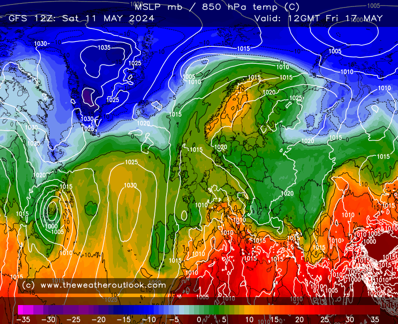
Um okay... so GFS has come up with an entirely new solution which sees the southernmost low become stretched out in its formative stages, with the leading edge racing off NE to land a glancing blow on the northern half of the UK while the trailing edge dangles down west of Europe, resulting in a weak ridge centred across north-central Europe. 


Quite the difference to the Scandi block that was trending across the past few GFS runs!


So this run is sort of like taking the ECM 00z, taking out some of the aggressiveness, but then adding further complications. Has to be said though, I have seen this stringing-out of secondary lows plenty enough times to know it really could unfold that way. Even if it doesn't the UKMO 12z looks capable of producing a similar outcome for Thu-Fri provided the Atlantic trough elongates south or south-eastward as it weakens.


Perhaps we'll be living a sultry but dangerous existence going into June?


Incredibly enough, I noticed GEM toying around with this idea yesterday. Surely not another plume spotted by that model first? 


In all honesty though, next week is looking very hard to call, even to start with as Monday remains capable of bringing to a large part of England and perhaps Wales anything from sunshine and a few well-scattered showers to leaden skies and persistent heavy rain.


GFS is trying for the miraculous save following only a brief spell of rain... nice to see this trend toward more of an AH influence but unless ECM joins forces I will have to keep my skeptical hat on.


If you have any problems or queries relating to TWO you can Email [email protected] 🙂
https://twitter.com/peacockreports 
2021's Homeland Extremes:
T-Max: 30.4°C 21st Jul | T-Min: -6.8°C New Years Day! | Wettest Day: 34.1mm 2nd Oct | Ice Days: 2 (27th Jan & 8th Feb)
Keep Calm and Forecast On
White Meadows
25 May 2017 17:46:00
Lovely prospects in the output today for heat lovers.
Ok nothing extreme or way above average but a nice trend to somewhere different from this time last week.
Bring on the heat!
cultman1
25 May 2017 17:52:51
Encouraging, as I was under the impression the bank holiday weekend weather for most of the UK ,especially later on, was looking like going downhill .....
Nick Gilly
25 May 2017 18:07:55
The 12Z GFS run looks good too, with HP dominating.
moomin75
25 May 2017 19:02:17

Originally Posted by: Nick Gilly 

The 12Z GFS run looks good too, with HP dominating.


Indeed. And the ECM has taken a step back from the unsettled nature of next week and appears to be trending towards GFS. I must say as Gav has said the Azores high is looking very "ridgy" this year. Hopefully bodes well for summer.


Witney, Oxfordshire
100m ASL
David M Porter
25 May 2017 19:34:41

Originally Posted by: moomin75 


Indeed. And the ECM has taken a step back from the unsettled nature of next week and appears to be trending towards GFS. I must say as Gav has said the Azores high is looking very "ridgy" this year. Hopefully bodes well for summer.


Someone mentioned in the previous thread that Tenerife seemingly had some very hot weather back in March, and commented that they wondered if that could be a sign that the Azores High is fairly strong this year. We can but hope!


Lenzie, Glasgow

"Let us not take ourselves too seriously. None of us has a monopoly on wisdom, and we must always be ready to listen and respect other points of view."- Queen Elizabeth II 1926-2022
The Beast from the East
25 May 2017 20:37:49
As someone who hates the heat, this is an uncomfortable period! Especially when out canvassing
"We have some alternative facts for you"
Kelly-Ann Conway - special adviser to the President
doctormog
25 May 2017 20:52:04

Originally Posted by: The Beast from the East 

As someone who hates the heat, this is an uncomfortable period! Especially when out canvassing


Surely virtue signalling isn't directly affected by the heat? 


On the subject of the models, it does look a bit messy in the short to medium term, albeit never cool


cultman1
25 May 2017 21:03:30
BBC weatherat 9.55pm says thundery breakdown for SE now from Saturday morning and Sunday and Monday suggest cloudy with heavy rain throughout for this region ?
Arcus
25 May 2017 21:32:05

Originally Posted by: cultman1 

BBC weatherat 9.55pm says thundery breakdown for SE now from Saturday morning and Sunday and Monday suggest cloudy with heavy rain throughout for this region ?


A complex situation, but as I said yesterday the S and SE are likely to see the heat and humidity maintained into Sunday with heavy showers likely Sunday PM into Monday. Nothing has changed in the outlook, but uncertainty persists Sunday/Monday.  


Ben,
Nr. Easingwold, North Yorkshire
30m asl
LA2B MeridFlowEuro09
26 May 2017 00:45:28

It is set to be mainly dry for most, with some normal sunny and very warm or just warm conditions.  


Very slack and uninteresting Pressure and weather pattern and not much in the way of heavy showers at all, very mundane and although some very warm days and nights especially next few days, and further very warm dry sunny weather is being shown for after Wednesday next week ahem.😆☀️😎.


I have read a few pages on here today Thursday 25th.  I have to say keep up the morale and interest especially stormchaser.


Climate is warming up, Scotland and N Ireland and North England still often gets some Winter frost, ice and snow, November to March, but the SE and South UK including S Central England and Wales, together with the West and North through the year, they sometimes get more rain than London and S SE England, where some longer dry fine spells without much heavy rain is seen every year.

The North Atlantic Sea often gets some much Colder Wintry conditions from November to March Months, and Mild SW and South winds tend to be more frequent over the East and SE of North Atlantic Sea, as the Azores High tends to stay in charge. 

With this warmth and heat, the Central and South UK has become mostly free of snow and frost.
Rob K
26 May 2017 09:23:08
The GFS temperature forecasts look pretty woeful today: they're going for a maximum of 24C for the London area, and Heathrow was already at 24C at 10am!
Yateley, NE Hampshire, 73m asl
"But who wants to be foretold the weather? It is bad enough when it comes, without our having the misery of knowing about it beforehand." — Jerome K. Jerome
cultman1
26 May 2017 09:44:26
GFS often underestimate the temperatures. I expect 27 in London today , the same tomorrow ,and 25 Sunday. Monday sadly another matter much cooler...
Bertwhistle
26 May 2017 16:47:02

Originally Posted by: Rob K 

The GFS temperature forecasts look pretty woeful today: they're going for a maximum of 24C for the London area, and Heathrow was already at 24C at 10am!


Modelled 24 for us too Rob; managed 26. Weekend- including BHM- looking promising, after rain tonight.


Bertie, Itchen Valley.
'We'll never see 40 celsius in this country'.
Stormchaser
26 May 2017 17:15:26


A pretty amazing degree of difference between the 06z and 12z GFS runs with respect to the behaviour of the Atlantic and Scandi-Asian troughs in just 5 days time. 


So they will either be poised to interact and encourage disturbances to keep moving across the UK from time to time between the two, or they will stay distanced and allow us to enjoy fine weather under the separating ridge.


Nice and clear isn't it? 


If you have any problems or queries relating to TWO you can Email [email protected] 🙂
https://twitter.com/peacockreports 
2021's Homeland Extremes:
T-Max: 30.4°C 21st Jul | T-Min: -6.8°C New Years Day! | Wettest Day: 34.1mm 2nd Oct | Ice Days: 2 (27th Jan & 8th Feb)
Keep Calm and Forecast On
David M Porter
26 May 2017 19:20:13

Originally Posted by: Stormchaser 


A pretty amazing degree of difference between the 06z and 12z GFS runs with respect to the behaviour of the Atlantic and Scandi-Asian troughs in just 5 days time. 


So they will either be poised to interact and encourage disturbances to keep moving across the UK from time to time between the two, or they will stay distanced and allow us to enjoy fine weather under the separating ridge.


Nice and clear isn't it? 


Maybe it's just me James, but I rather get the impression that the models have been all over the place at times this month, and I don't just mean their far FI solutions. Even the normally trusted ECM op runs in the ten day range have been varying notably from one run to the next at times of late.


Prospects from mid-next week onwards are subject to much conjecture at the moment; I think a lot will depend upon the behaviour of the low in the atlantic.


Lenzie, Glasgow

"Let us not take ourselves too seriously. None of us has a monopoly on wisdom, and we must always be ready to listen and respect other points of view."- Queen Elizabeth II 1926-2022
Stormchaser
26 May 2017 19:47:54

Originally Posted by: David M Porter 


Maybe it's just me James, but I rather get the impression that the models have been all over the place at times this month, and I don't just mean their far FI solutions. Even the normally trusted ECM op runs in the ten day range have been varying notably from one run to the next at times of late.


Prospects from mid-next week onwards are subject to much conjecture at the moment; I think a lot will depend upon the behaviour of the low in the Atlantic.


I'm fairly sure it's not just you David; I have also noticed the unusually wide variation of output, and I can see reasons why:


  1. There's a 5-wave pattern in the atmosphere (5 major ridges and troughs) which is 1-2 more than usual and means the atmosphere is pretty much at maximum complexity.

  2. The region inside the Arctic circle has a distribution of temperatures that hasn't been seen since the extent made the sudden large decline in 2007 from which it has never sustainable recovered, with anomalously cold conditions north of Scandinavia but warmer than normal conditions on the Pacific side. I can see this driving blocking patterns in a different way to recent years, and one rarely observed before, if ever.

  3. A strong pulse of the MJO is set to occur in the eastern Indian Ocean (see left-hand chart below) at a time when the atmospheric response is undergoing seasonal changes; the composite for May is much more unsettled for the UK than that for June, and it's possible that GFS in particular has been heading toward one, then the other, and back again, due to uncertainty regarding how quickly the seasonal changes progress.


I can sure see a lot of the June response in the GFS 12z run, while by contrast the ECM 12z is more akin to a May response, though the signal for there to be such a flat westerly flow by days 8-10 seems to come from somewhere else (and could even just be the model acting up).


If you have any problems or queries relating to TWO you can Email [email protected] 🙂
https://twitter.com/peacockreports 
2021's Homeland Extremes:
T-Max: 30.4°C 21st Jul | T-Min: -6.8°C New Years Day! | Wettest Day: 34.1mm 2nd Oct | Ice Days: 2 (27th Jan & 8th Feb)
Keep Calm and Forecast On
Brian Gaze
27 May 2017 06:54:16

Subtle changes in the short term output this morning. The Bank Holiday weekend looks more promising for southern areas.


Brian Gaze
Berkhamsted
TWO Buzz - get the latest news and views 
"I'm not socialist, I know that. I don't believe in sharing my money." - Gary Numan
Sinky1970
27 May 2017 07:52:32
Next week seems to be improving - according to the GFS model that is.
Users browsing this topic

Ads