CreweCold
14 November 2016 14:47:21

Originally Posted by: traveller1983 


Just looking at met office CFS updated .

Shows above average temperature s for the UK and most of central Europe around average or below when last month it was the other way around.
Also the northern Atlantic and pacific cools and equatorial pacific warms.
Is this their mild bias? But is this game over for the UK ? Ita showing all the UK? Or is it uncertainty and as alluded to - their mild bias.?

http://www.metoffice.gov.uk/research/climate/seasonal-to-decadal/gpc-outlooks/glob-seas-prob


Well for starters that's not the CFS...That's the Metoffice GLOSEA5 long range model.


Secondly I'd advise not to take much notice of the 2m temperature anomalies on any long ranger as they always seem to be very sketchy. The MSLP anomalies are the most important to me. 


I'd say that (especially in the Jan-Mar period) we see a battleground Britain scenario on the GLOSEA model with the jet diving down through the UK from the N&NW and LP meeting colder continental air to the E.


Crewe, Cheshire
55 metres above sea level
roger63
  • roger63
  • Advanced Member Topic Starter
14 November 2016 16:00:23

Originally Posted by: CreweCold 


Well for starters that's not the CFS...That's the Metoffice GLOSEA5 long range model.


Secondly I'd advise not to take much notice of the 2m temperature anomalies on any long ranger as they always seem to be very sketchy. The MSLP anomalies are the most important to me. 


I'd say that (especially in the Jan-Mar period) we see a battleground Britain scenario on the GLOSEA model with the jet diving down through the UK from the N&NW and LP meeting colder continental air to the E.


I find it helps to look at the two category charts.Looking at this;


Pressure shows little variation from the norm except for small areas of  slightly higher than  average HP to the N and NE of the UK


SST's  a large area of lower than average SST's in Mid Atlantic south of Iceland,and broken patches of colder SST' s to north sand NE of Scotland


Precipitation Most of the map covered with normal precipitation.Exception is Northern/Russian  Arctic where large areas strongly above normal precipitation.


Temperature.Resoundingly above average temperatures.


The problem is that the METO had hinted of a winter of two different halves colder first half,warmer second ,so the average could be misleading.


However when you look at CFS charts which have monthly splits mild dominates in every winter month!

14 November 2016 16:28:26
If it's colder first half then why are the temps always showing above average? Like they did or had done for autumn and it's been cold and blocked so far?!
Medlock Vale Weather
14 November 2016 16:43:28

I still think we will have a similar Winter to 08-09. Certainly colder & snowier than the last 3 Winters but not a 2010 Winter. Just a huntch so I could be wrong. I think the real deal will be from next Winter onwards as we see a continuing weak sun.


Alan in Medlock Valley - Oldham's frost hollow. 103 metres above sea level.
What is a frost hollow? http://www.weatheronline.co.uk/reports/wxfacts/Frost-hollow.htm 
Brian Gaze
14 November 2016 17:02:08

The latest Met Office probability maps don't seem to suggest a colder than average winter. I agree that 2m temps can be misleading but 500s suggest a slim chance of lower heights over southern Europe. How would I marry this to the media statements? The only thing I can think of is the probability of a cold December followed by mild January and February. 


Brian Gaze
Berkhamsted
TWO Buzz - get the latest news and views 
"I'm not socialist, I know that. I don't believe in sharing my money." - Gary Numan
Stormchaser
14 November 2016 17:07:30

Originally Posted by: roger63 


However when you look at CFS charts which have monthly splits mild dominates in every winter month!


That doesn't fit with the 700 hPa anomaly charts, well at least not for Dec... I think that Jan-Feb is a classic case of the model overdoing the low pressure systems in the Atlantic even as and when they undercut the blocking highs. I've seen that many, many times with the model in the past, and the GFS used to be guilty of it at times - less so these days but with the GEFS still susceptible on occasion.


I'd not be surprised if the trough disruption mechanisms typically involved when blocking highs are at large are not able to be adequately resolved by any of the longer-range models, including GloSea5. So with a block to the NW and low pressure undercutting, mild southwesterly winds keep making inroads when in reality the low would be less organised, tending to elongate with a secondary feature splitting off and heading into Europe, so allowing the cold air to remain entrenched.


Now, I'm loathe to post CFS charts given it's dodgy track record, but they're worth a gander for entertainment value:


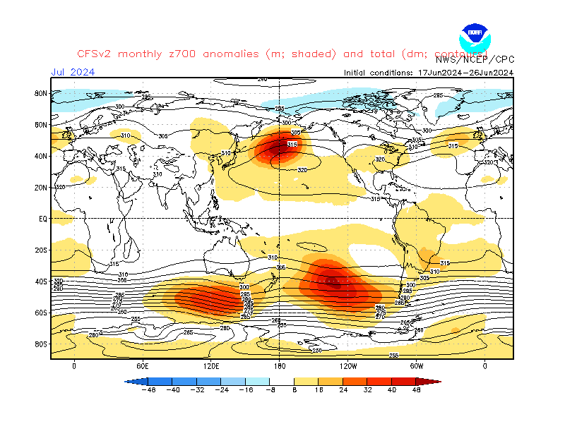
Blocking, blocking and more blocking. 


Let's just hope we don't end up with a high-latitude b0ll0cking instead 


If you have any problems or queries relating to TWO you can Email [email protected]

https://twitter.com/peacockreports 
2023's Homeland Extremes:
T-Max: 30.2°C 9th Sep (...!) | T-Min: -7.1°C 22nd & 23rd Jan | Wettest Day: 25.9mm 2nd Nov | Ice Days: 1 (2nd Dec -1.3°C in freezing fog)
Keep Calm and Forecast On
Stormchaser
14 November 2016 17:10:07

Originally Posted by: Global Warming 


I have had a look at what the QBO was doing in each of the months from December to March since 1987 which have been significantly below average. Here is what the numbers look like.


Following on from my earlier post - I looked at some data going further back, and 1977 turned out to be another strong match for 2016, in fact the 70 hPa level is within 5 m/s of 2016 for the entire period Jan-Oct. Who fancies another blizzard of '78?! 


If you have any problems or queries relating to TWO you can Email [email protected]

https://twitter.com/peacockreports 
2023's Homeland Extremes:
T-Max: 30.2°C 9th Sep (...!) | T-Min: -7.1°C 22nd & 23rd Jan | Wettest Day: 25.9mm 2nd Nov | Ice Days: 1 (2nd Dec -1.3°C in freezing fog)
Keep Calm and Forecast On
Winters Tale
14 November 2016 17:28:03

Hi Brian,


The Metoffice charts that you posted suggest to me that average sea level 500 hpa heights will be higher than normal through the main winter period to our north and over Scandinavia. And these charts tie in quite nicely with the ECMWF seasonal updates which also point to higher than average heights to our north during the winter period. 


My hunch based on the seasonal model outputs that I have seen this far and various winter updates is that December to mid january will see the coldest winter weather this season with the cold moderating after mid January some what.


Whilst I very much doubt we will see a December 2010 scenario this year, I think that we could see a potentially cold December akin to December 2009 and a cold start to January with a moderation of the cold as we head into mid and late January.


I do feel that this winter has a lot of wintery potential especially when you compare it to the last 2 or 3 winters.


Grant


Saint Snow
14 November 2016 20:56:28

Originally Posted by: Medlock Vale Weather 


I still think we will have a similar Winter to 08-09. Certainly colder & snowier than the last 3 Winters but not a 2010 Winter. Just a huntch so I could be wrong.


The 2008/9 winter was awful here. Just been looking through my pic library to refresh my memory, and I don't think we got any lying snow IMBY. There's some pics of me & eldest daughter (aged just 6!!) in the Peak District with sledges, but that's the only snow.


I could go a Winter 09/10, though - we had about 4-5 weeks overall of lying snow, including a few inches of snowcover on Xmas Day itself.


Martin
Home: St Helens (26m asl) Work: Manchester (75m asl)
A TWO addict since 14/12/01
"How can wealth persuade poverty to use its political freedom to keep wealth in power? Here lies the whole art of Conservative politics."
Aneurin Bevan
Solar Cycles
14 November 2016 21:16:19

Originally Posted by: Saint Snow 


The 2008/9 winter was awful here. Just been looking through my pic library to refresh my memory, and I don't think we got any lying snow IMBY. There's some pics of me & eldest daughter (aged just 6!!) in the Peak District with sledges, but that's the only snow.


I could go a Winter 09/10, though - we had about 4-5 weeks overall of lying snow, including a few inches of snowcover on Xmas Day itself.


We had a dusting or two and when I say dusting that's being kind really. As for 09/10 a fantastic winter though we didn't get a great deal of snow compared to other areas but I guess 6" isn't to be sniffed at, or so they say. 😜


I'm hoping for a combination of 78/79, December 2010 and February 1947. Surely that's not to much to ask for.

KevBrads1
15 November 2016 05:51:47

Originally Posted by: Saint Snow 


The 2008/9 winter was awful here. Just been looking through my pic library to refresh my memory, and I don't think we got any lying snow IMBY. There's some pics of me & eldest daughter (aged just 6!!) in the Peak District with sledges, but that's the only snow.


I could go a Winter 09/10, though - we had about 4-5 weeks overall of lying snow, including a few inches of snowcover on Xmas Day itself.


Manchester Winter Index for winter 2008-09 was 105, best winter since 1995-96. If that winter is being described as awful then what is the description for 2013-14! 


MANCHESTER SUMMER INDEX for 2021: 238
Timelapses, old weather forecasts and natural phenomena videos can be seen on this site
http://www.youtube.com/channel/UCgrSD1BwFz2feWDTydhpEhQ/playlists
David M Porter
15 November 2016 09:09:49

Originally Posted by: KevBrads1 


Manchester Winter Index for winter 2008-09 was 105, best winter since 1995-96. If that winter is being described as awful then what is the description for 2013-14! 


Indeed, and what about last winter to boot! Winter 2015-16 was virtually a re-run of 2013-14.


Lenzie, Glasgow

"Let us not take ourselves too seriously. None of us has a monopoly on wisdom, and we must always be ready to listen and respect other points of view."- Queen Elizabeth II 1926-2022
some faraway beach
15 November 2016 09:16:49

Originally Posted by: Brian Gaze 


The latest Met Office probability maps don't seem to suggest a colder than average winter. I agree that 2m temps can be misleading but 500s suggest a slim chance of lower heights over southern Europe. How would I marry this to the media statements? The only thing I can think of is the probability of a cold December followed by mild January and February. 


I have to agree. What particularly worries me is that orange shade between the Azores and the Canaries in the topmost chart. A 60-80% chance of higher-than-average heights in that region would scupper any chance of wintry weather for the British Isles. How many times during winter do we comment plaintively that nothing cold is coming our way until that Azores high disappears?


On the plus-side, I don't give these ensemble outputs much credibility at all, whether they're from CFS, MetO or ECM. You only have to look at the gigantic range of solutions in the model output ensembles for Sunday night onwards right now to start feeling dubious about the same spread of results being extended for another 3 months.


2 miles west of Taunton, 32 m asl, where "milder air moving in from the west" becomes SNOWMAGEDDON.
Well, two or three times a decade it does, anyway.
polarwind
15 November 2016 10:26:23

Originally Posted by: some faraway beach 


I have to agree. What particularly worries me is that orange shade between the Azores and the Canaries in the topmost chart. A 60-80% chance of higher-than-average heights in that region would scupper any chance of wintry weather for the British Isles. How many times during winter do we comment plaintively that nothing cold is coming our way until that Azores high disappears?


On the plus-side, I don't give these ensemble outputs much credibility at all, whether they're from CFS, MetO or ECM. You only have to look at the gigantic range of solutions in the model output ensembles for Sunday night onwards right now to start feeling dubious about the same spread of results being extended for another 3 months.


Depends imo, on where the ridging points. NE warm/mild, NW as recently then cold/very cold.


"The professional standards of science must impose a framework of discipline and at the same time encourage rebellion against it". – Michael Polyani (1962)
"If climate science is sound and accurate, then it should be able to respond effectively to all the points raised…." - Grandad
"The whole problem with the world is that fools and fanatics are always so certain of themselves, and wiser people so full of doubts". - Bertrand Russell
"Science is the belief in the ignorance of the experts" – Richard Feynman
"A consensus means that everyone agrees to say collectively what no one believes individually.”- Abba Eban, Israeli diplomat
Dave,Derby
Saint Snow
15 November 2016 10:27:36

Originally Posted by: KevBrads1 


Manchester Winter Index for winter 2008-09 was 105, best winter since 1995-96. If that winter is being described as awful then what is the description for 2013-14!  


Not sure how your MWI scored so highly. I don't remember any snow lying (although do recall a couple of visits to clients in Yaaarksher, where there was decent snow on the ground)


Martin
Home: St Helens (26m asl) Work: Manchester (75m asl)
A TWO addict since 14/12/01
"How can wealth persuade poverty to use its political freedom to keep wealth in power? Here lies the whole art of Conservative politics."
Aneurin Bevan
some faraway beach
15 November 2016 13:35:56

Originally Posted by: polarwind 


Depends imo, on where the ridging points. NE warm/mild, NW as recently then cold/very cold.


Can't argue with that. But still a lot simpler for the British Isles to access cold when there's no ridging in the Azores at all. Rather than hoping the Azores High is tilted NW to SE, I'd prefer some areas of even the weakest low pressure down there, so there's nothing to prevent the jet stream diving south and bringing southerly tracking lows with it.


But I take your point. It doesn't rule out cold, even though it makes it a little more difficult to justify a cold forecast.


2 miles west of Taunton, 32 m asl, where "milder air moving in from the west" becomes SNOWMAGEDDON.
Well, two or three times a decade it does, anyway.
Gooner
15 November 2016 14:05:10

Originally Posted by: some faraway beach 


Can't argue with that. But still a lot simpler for the British Isles to access cold when there's no ridging in the Azores at all. Rather than hoping the Azores High is tilted NW to SE, I'd prefer some areas of even the weakest low pressure down there, so there's nothing to prevent the jet stream diving south and bringing southerly tracking lows with it.


But I take your point. It doesn't rule out cold, even though it makes it a little more difficult to justify a cold forecast.


Spot on IMO


Remember anything after T120 is really Just For Fun


Marcus
Banbury
North Oxfordshire
378 feet A S L


roger63
  • roger63
  • Advanced Member Topic Starter
15 November 2016 15:33:25

http://www.cpc.ncep.noaa.gov/products/CFSv2/htmls/euT2me3Mon.html


Just looked at latest CFS monthly forecast maps for temerature As I understand it E1 is the earliest run (which shows mild) whilst E3 is the most up to date which shows a much colder scenario for much of Europe in December in particular.


Is my interpretation correct?

KevBrads1
15 November 2016 16:23:41
Snow during winter 2008-09


MANCHESTER SUMMER INDEX for 2021: 238
Timelapses, old weather forecasts and natural phenomena videos can be seen on this site
http://www.youtube.com/channel/UCgrSD1BwFz2feWDTydhpEhQ/playlists
Medlock Vale Weather
15 November 2016 17:11:27

Originally Posted by: Saint Snow 


Not sure how your MWI scored so highly. I don't remember any snow lying (although do recall a couple of visits to clients in Yaaarksher, where there was decent snow on the ground)


Crazy the differences in our region over relatively short distances - we did pretty well here for snow in 08-09. Looks like Kev did too. Around here we had a decent covering in the December, lighter coverings in January and then it culminated in a very good fall in the Feb with some minor drifting which stuck around for days in the shade. IMBY it was definitely the best Winter since the mid 90's. Of course 09-10 was better still, epic even.


Alan in Medlock Valley - Oldham's frost hollow. 103 metres above sea level.
What is a frost hollow? http://www.weatheronline.co.uk/reports/wxfacts/Frost-hollow.htm 
Users browsing this topic

Ads