Gusty
13 March 2021 09:21:16
https://www.wetterzentrale.de/maps/ECMOPEU00_168_1.png 


A definite risk of snow for parts of the SE at 144-168 if some of this output were to verify. One to watch. 


Steve - Folkestone, Kent
Current conditions from my Davis Vantage Vue
https://www.wunderground.com/dashboard/pws/IFOLKE11 
Join Kent Weather on Facebook.
https://www.facebook.com/stevewall69/ 


Hippydave
13 March 2021 15:22:16

No one interested in the chance of a little spring cold/snow I'm guessing


Still some uncertainty about whether it'll be chilly or cold for the time of year (for later next week that is) but both ECM and GEM operationals go for the latter, with GEM bringing quite a few snow showers with it and uppers briefly touching -12. 


I'd imagine if the pattern came off close to the GEM setup there'd be some fun land based convections kicking off too with cold uppers and surface heating.


As the setup is HP based, out of the wind I'd imagine it'll feel quite pleasant, although more likely biased towards the West as cool/cold uppers and an Easterly flow in March isn't going to be warm down the Eastern half.


Home: Tunbridge Wells
Work: Tonbridge
moomin75
13 March 2021 16:43:30

Originally Posted by: Hippydave 


No one interested in the chance of a little spring cold/snow I'm guessing


Still some uncertainty about whether it'll be chilly or cold for the time of year (for later next week that is) but both ECM and GEM operationals go for the latter, with GEM bringing quite a few snow showers with it and uppers briefly touching -12. 


I'd imagine if the pattern came off close to the GEM setup there'd be some fun land based convections kicking off too with cold uppers and surface heating.


As the setup is HP based, out of the wind I'd imagine it'll feel quite pleasant, although more likely biased towards the West as cool/cold uppers and an Easterly flow in March isn't going to be warm down the Eastern half.


Not interested in the slightest in cold late March. Never have been, never will be.


Witney, Oxfordshire
100m ASL
Karl Guille
13 March 2021 17:50:05
Looks like an early taste of Spring is off the cards for the far south later next week!
https://www.theweatheroutlook.com/charts/gem/12_165_mslp850.png 

St. Sampson
Guernsey
Surrey John
13 March 2021 18:44:14

Originally Posted by: Hippydave 


No one interested in the chance of a little spring cold/snow I'm guessing


Had a few flakes mixed in with a sleety shower this afternoon.


Unless getting decent amount to cover everything, don’t need any more marginal snow


Bradford on Avon, Wiltshire
35m ASL
Stormchaser
13 March 2021 19:35:14

Chart image


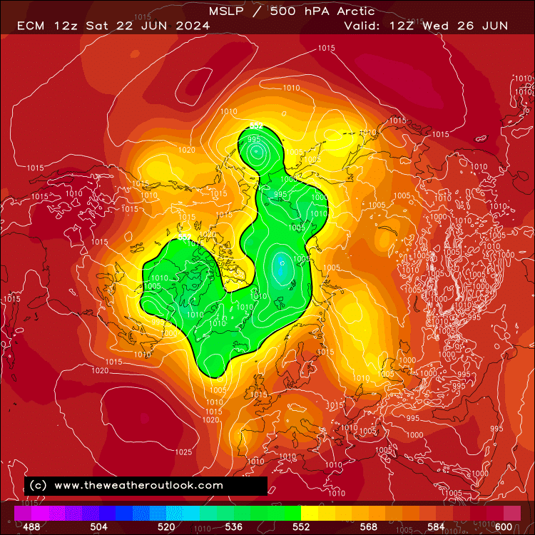
The setup next week looks pretty extraordinary to my eyes.


The subtropical high is on steroids, ridging impressively far north in the face of a strong polar vortex.


9 times out of 10, that polar vortex would flatten the ridge before more than a whiff of cold air made its way across any of the UK - but on this occasion, a slight cut-back of the polar jet on the eastern flank and a 'nose' of high pressure to the north of Scandinavia, join forces to keep the high from toppling just long enough that a significant shot of cold air makes its way across southern UK Thu-Fri. 


It's just about enough that snow showers are feasible in the southeast for a time.


Usual caveats apply of course - ECM's making a bit more of this than GFS.


Following this sort of 'sausage high' driven easterly, we typically see the subtropical ridge extension move across the UK for a number of days, bringing a substantial climb in temperatures. This is nicely demonstrated by the ECM 12z.


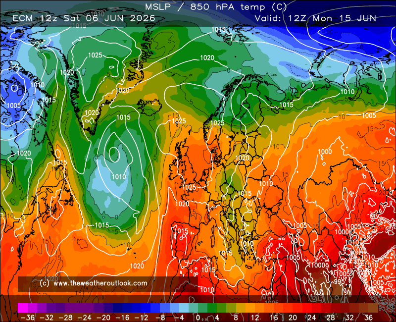
The GFS 06z also gave it a good go, but the 12z has reverted to producing height rises to the northwest. That'd make this an even stranger month relative to the La Nina, strong polar vortex background (usually a predominantly mild combination)!


If you have any problems or queries relating to TWO you can Email [email protected] 🙂
https://twitter.com/peacockreports 
2021's Homeland Extremes:
T-Max: 30.4°C 21st Jul | T-Min: -6.8°C New Years Day! | Wettest Day: 34.1mm 2nd Oct | Ice Days: 2 (27th Jan & 8th Feb)
Keep Calm and Forecast On
DEW
  • DEW
  • Advanced Member
14 March 2021 08:02:51

GFS shows HP pushing N-wards and by Fri 19th importing tropical air to Shetlands while E-lies on its S flank bring in some rather cold weather (though not as cold in this model as some posts above expect, nor did the BBC last night imply such extremes). The HP flattens out across the UK Tue 23rd and kills the E-lies before scooting off to Norway. There follows a stand-off between a Norway-Italy ridge of HP and Atlantic LP with S-lies (and probably local troughs) approaching Ireland but not making much progress E-wards.


GEFS goes along with this, with temps in the S dipping 7 or 8 C below norm Sat 20th before recovering quickly in most (but by no means all) runs Tue 23rd followed by a period with mean (& op & control) close to norm though quite a lot of uncertainty. Little sign of a dip in Scotland, though for any positive boost you have to look to the far N (Inverness) Uncertainty also prevails there. Not much rain about, though some in the W later on (from Thu 25th)


ECM similar to GFS, though the cold spell is rather more of a glancing blow from the NE than a full-on E-ly.


War does not determine who is right, only who is left - Bertrand Russell

Chichester 12m asl
Retron
14 March 2021 09:20:56

Originally Posted by: Gusty 


A definite risk of snow for parts of the SE at 144-168 if some of this output were to verify. One to watch. 


A mention of it in today's SE Met Office outlook:


"Continuing cold into Thursday with showers, these perhaps heavy and wintry."


I was thinking yesterday that it was like a typical April day - sunny, breezy, then the odd downpour with temperatures plummeting, only to swiftly recover as the sun came out again.


Looks like more of the same to come!


Leysdown, north Kent
idj20
14 March 2021 09:56:20

Well, the good news is the Atlantic likely to be kept at arm's length so it'll be quite a while before we get to experience any more storminess, but the bad news is how it'll remain stubbornly cold over Kent thanks to high pressure residing to the west and north of the UK. Shades of Spring 2013? 


Folkestone Harbour. 
briggsy6
14 March 2021 10:36:48

Nick Abbott on LBC last night suggested that March could be heading towards being the wettest on record. Is there any truth in this? I vaguely remember march 1981 being very wet - this month so far doesn't feel to have been anything like on a par with that so far. 


Location: Uxbridge
Schnow in Peace
14 March 2021 14:11:55

You can see where the Met are coming from looking at that ECM. The blocking is stronger and shifted further north than in recent days. UKMO at 120 is similar but not as keen thereafter.


Is quite noticeable how these colder high pressure scenarios keep popping up this month - and that in the absence of other favourable signals. Maybe a follow on from the various warmings. 


As for March 1981, I think I can remember some long lasting rain events along with possibly a heavy wet snow event over two days IIRC. Extremely slushy in mid Essex but I think high Suffolk got a good dumping. I remember looking out the window those two days in abject frustration...as it just wouldn't turn and the slush wouldn't rise higher!!!

Stormchaser
14 March 2021 19:01:51

Originally Posted by: briggsy6 


Nick Abbott on LBC last night suggested that March could be heading towards being the wettest on record. Is there any truth in this? I vaguely remember march 1981 being very wet - this month so far doesn't feel to have been anything like on a par with that so far. 


According to NCEP/NCAR reanalysis, the month up to 12th was near-average in England & Wales, above in Scotland.


Since then it's been a bit soggy but not seriously so for most. Probably enough that E&W rainfall is a little above average to 14th.


Going forward, the outlook is far from a wet one, as strong high pressure slowly drifts across the UK from west to east (but with a northward jump for a time Thu-Fri), so I've no idea what Nick Abbott was working with there! 


If you have any problems or queries relating to TWO you can Email [email protected] 🙂
https://twitter.com/peacockreports 
2021's Homeland Extremes:
T-Max: 30.4°C 21st Jul | T-Min: -6.8°C New Years Day! | Wettest Day: 34.1mm 2nd Oct | Ice Days: 2 (27th Jan & 8th Feb)
Keep Calm and Forecast On
Stormchaser
14 March 2021 19:10:33

A shockingly large shift from ECM between the 00z and 12z today. One of the biggest I can recall in the midrange; from an impressively cold few days with snow showers widely across the middle-3rd of the UK at the peak on Friday, to merely a bit cold in the southeast, mainly by night when frosts could give tender plants some trouble.


I did think the colder outcomes looked a bit heavily dependent on small lows moving in just the right way, but still...!


Longer term, plenty of signs that the high will drift right across the UK for at least a few days. Could turn pleasantly warm in the sunshine .


If you have any problems or queries relating to TWO you can Email [email protected] 🙂
https://twitter.com/peacockreports 
2021's Homeland Extremes:
T-Max: 30.4°C 21st Jul | T-Min: -6.8°C New Years Day! | Wettest Day: 34.1mm 2nd Oct | Ice Days: 2 (27th Jan & 8th Feb)
Keep Calm and Forecast On
moomin75
14 March 2021 19:18:13

Originally Posted by: Stormchaser 


A shockingly large shift from ECM between the 00z and 12z today. One of the biggest I can recall in the midrange; from an impressively cold few days with snow showers widely across the middle-3rd of the UK at the peak on Friday, to merely a bit cold in the southeast, mainly by night when frosts could give tender plants some trouble.


I did think the colder outcomes looked a bit heavily dependent on small lows moving in just the right way, but still...!


Longer term, plenty of signs that the high will drift right across the UK for at least a few days. Could turn pleasantly warm in the sunshine .


Frankly, at this of the year, I am glad it has shifted so dramatically. Let's hope it stays that way. Cold charts at the middle to end of March are pointless and just not wanted by many.


Witney, Oxfordshire
100m ASL
fairweather
14 March 2021 19:47:23

Originally Posted by: briggsy6 


Nick Abbott on LBC last night suggested that March could be heading towards being the wettest on record. Is there any truth in this? I vaguely remember march 1981 being very wet - this month so far doesn't feel to have been anything like on a par with that so far. 


Well at the moment it's the driest month for six months and likely to stay that way judging by the charts!


S.Essex, 42m ASL
briggsy6
14 March 2021 21:39:29

Tbh Mr.Abbott has trouble doing conversions from celsius to fahrenheit so never sure whether to trust his meteorological musings.


Location: Uxbridge
four
  • four
  • Advanced Member
14 March 2021 23:16:46

Originally Posted by: briggsy6 


Nick Abbott on LBC last night suggested that March could be heading towards being the wettest on record. Is there any truth in this? I vaguely remember march 1981 being very wet - this month so far doesn't feel to have been anything like on a par with that so far. 


Well since the next two weeks look on the dry side with High Pressure never far away it seems unlikely.
March can be very wet at times but it is usually the first serious 'drying' month.
Here March April May are strikingly drier than the rest of the year.
GFS 18z looks considerably warmer than 12z after next weekend I thought. 


briggsy6
15 March 2021 00:28:03

My Collins weather guide has March as the driest month of the year on average for London anyway, slightly shading February.


Location: Uxbridge
DEW
  • DEW
  • Advanced Member
15 March 2021 07:09:01

Jetstream as before runnig in a loop N of the UK with the eastern side of the UK being touched by the stream as it returns S-wards, through to Sat 20th. A more conventional W-ly stream to the N of the UK to Sat 27th when a S-ly loop deep into mid-Atlantic develops and then the western side of the gets the return stream as it runs N-wards. More W-lies from Mon 29th.


GFS - HP currently to the SW ridging to Norway and bringing cold NE-ly in to the SE of the UK Fri 19th while Scotland has calm and milder weather. The HP then gradually slips S-wards and through to Tue 30th there is a more or less strong Sw-ly sandwiched between the HP mostly over France and LP near Iceland (with a brief break in the pattern Sun 28th as a more vigorous trough gets across to the UK)


GEFS - cool in the SE  (but not as dramatic as yesterday) and mild in the NW around Fri 19th but otherwise mean temp close to norm through to Wed 31st, a good deal of scatter between different runs but very few real outliers. Some rain towards the end of the period esp W & N.


ECM matches GFS though less  strong NE-ly at the end of this week


War does not determine who is right, only who is left - Bertrand Russell

Chichester 12m asl
Users browsing this topic

Ads