The Weather Outlook

Remove ads from site

stophe
06 February 2021 19:04:13


I agree. Where are they getting their data. I know it is meteogroup, bit have they just paid for a basic subscription

Originally Posted by: warrenb 

fullybhoy
06 February 2021 19:04:42


And even that only has 1-2 cm for me. I really hope there are some showers that the models are missing, as I was previously hoping I might get two or three inches from this.

Originally Posted by: Rob K 

1-2 cm more than for me, i’m in that lovely big gap in central Scotland ๐Ÿ™ˆ๐Ÿ˜‚


Alan

Glasgow 165m/asl

picturesareme
06 February 2021 19:09:49


Is that real? Something very strange going on there.

Originally Posted by: doctormog 

Metoffice similarly have 7C even by Friday down here.

polarwind
06 February 2021 19:12:35


BBC TV and radio forecasts have gone to sh1t since it contracted with Meteogroup. I think the Press Association has cut it to the bone in order to maximise profit. It’s a disgrace.

Originally Posted by: Justin W 

I agree - I realistically gave up on these forecasts not long after the switch.

Of course 'switching' is generally, an ongoing pain in the butt - perhaps the BBC can seek out other suppliers on the Internet? If the lowest price for the service is the criterion, then we won't get anything like reasonable forecasting accuracy and what everybody needs.


"The professional standards of science must impose a framework of discipline and at the same time encourage rebellion against it". โ€“ Michael Polyani (1962)

"If climate science is sound and accurate, then it should be able to respond effectively to all the points raisedโ€ฆ." - Grandad

"The whole problem with the world is that fools and fanatics are always so certain of themselves, and wiser people so full of doubts". - Bertrand Russell

"Science is the belief in the ignorance of the experts" โ€“ Richard Feynman

"A consensus means that everyone agrees to say collectively what no one believes individually.โ€- Abba Eban, Israeli diplomat

Dave,Derby

roadrunnerajn
06 February 2021 19:17:06

The Meto have us up to 8c on Thursday and 9c on Friday. That has been forecast for a few days now. Which is to be expected for our location. I’m looking now to developments next week as that looks very interesting. 
Those of you further east will stay in the cold air for longer.


Germoe, part of the breakaway Celtic Republic. 80m asl
NDunwell
06 February 2021 19:25:59

Not lasting long according to the beeb tonight


Originally Posted by: Gavin D 

That is an utter embarrassment and they'd be better off not gibing forecasts more than 24-48 hours ahead if they are to put up that crap. Sorry but that makes me angry, there is nothing to indicate that is an an accurate forecast based on data, It's like they've got an intern to come up with some numbers and symbols. Even if the weather ended up doing what is forecast there it is a disgrace to put that up...it is deceiving the public as i'm 90% sure those temps will be so far out to make them nonsense


Nick

Ruislip (2 miles from the Northolt recording station)

Caz
  • Caz
  • Advanced Member
06 February 2021 19:28:00


Location shown below user name on t he left for most of us!

Originally Posted by: fairweather 

It’s helpful if your location is also added to your signature because those viewing on some iPhone browsers can’t see the left hand frame.  Some members don’t put their location anywhere though, which is useless when reporting from ‘here’.  


Market Warsop, North Nottinghamshire.

Join the fun and banter of the monthly CET competition.

Gooner
06 February 2021 19:28:44


That is an utter embarrassment and they'd be better off not gibing forecasts more than 24-48 hours ahead if they are to put up that crap. Sorry but that makes me angry, there is nothing to indicate that is an an accurate forecast based on data, It's like they've got an intern to come up with some numbers and symbols. Even if the weather ended up doing what is forecast there it is a disgrace to put that up...it is deceiving the public as i'm 90% sure those temps will be so far out to make them nonsense

Originally Posted by: NDunwell 

I am finding the BEEB dreadful , they had Banbury as 7c today it didn't get above 3c , I have no doubt that forecast will change but you are right , the long term outlook should be 2 days 


Remember anything after T120 is really Just For Fun


Marcus

Banbury

North Oxfordshire

378 feet A S L


western100
06 February 2021 19:32:39


I am finding the BEEB dreadful , they had Banbury as 7c today it didn't get above 3c , I have no doubt that forecast will change but you are right , the long term outlook should be 2 days 

Originally Posted by: Gooner 

I am unsure why they do not remove those? They have to play it safe, they have no choice and the risk is so high to any organization who gets it wrong. Worse for them to be predicting severe cold and it ending up 6-7's. Less damage if they show 6-7 and it ends up 1-2, they will just be able to say " It really was chilly today". No one will remember they predicted 6-7 etc. However everyone will remember if they said -6 or -7


Worcestershire / Warwickshire Border

100m ASL

Xโ€ฆ..@Weather4u2

SJV
06 February 2021 19:35:00

Monday is looking potentially very interesting here. I've been watching the GEM in particular, as it has consistently modelled the Humber streamer setting up shop across the region, but now it's modelled on the FAX as a convergence zone I am really quite excited now  

Caz
  • Caz
  • Advanced Member
06 February 2021 19:38:44

Monday is looking potentially very interesting here. I've been watching the GEM in particular, as it has consistently modelled the Humber streamer setting up shop across the region, but now it's modelled on the FAX as a convergence zone I am really quite excited now  

Originally Posted by: SJV 

Do you think we’ll get that here as well Steve?


Market Warsop, North Nottinghamshire.

Join the fun and banter of the monthly CET competition.

Quantum
  • Quantum
  • Advanced Member Topic Starter
06 February 2021 19:44:55


Please note: this is valid from midnight to midnight tommorow. Snow that falls today or early on Monday is not included.

Updated snow risk map. I haven't changed a huge amount. I stand by most of what I said before.

https://i.ibb.co/MDLLzMp/sundaysnowamounts-V2.png 
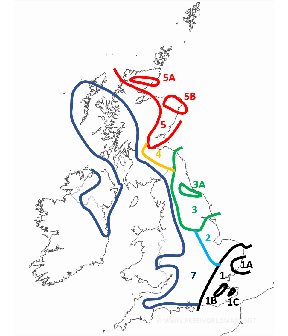
 

sundaysnowamounts-V2


Region 1: 2-7cm generally with more for the more south eastern parts of the region. Around the border expect less than 2cm. With patchy snow occasionally extending outside of the region.

Region 1A: More than 3cm with locally as much as 9cm

Region 1B: In the early afternoon the snow is expected to start banding with some convective activity enhancing the front. Locally as high as 20cm. This area in particular could get an absolute dumping.

Region 1C: Similar to 1B, enhanced snow activity expected here. With 5-10cm expected.

Region 2: Occasional snow showers but negligable amounts. During the late afternoon and evening heavy snow showers are expected particularly in the NE of the region giving 2-5cm locally. Some of the snow showers are likely to band and form streamers, though this is more of a hazard for early monday.

Region 3: Snow showers most of the day, especially mid morning onwards. Mostly light or moderate but occasionally heavy. Highly variable snow amounts. 1-5cm generally.

Region 3A: Showers expected to be concentrated and heavier around this region. 3-7cm.

Region 4: Light or moderate scattered snow showers. Smaller amounts expected here. 1-3cm

Region 5: Heavy but often scattered snow showers. Amounts highly variable. 1-10cm, higher amounts expected on higher ground and in the north of the region.

Region 5A: More frequent showers expected here. 3-10cm.

Region 5B: More frequent and sometimes heavier snow showers here. Also possibility of a streamer. 5-10cm.

Region 7 (appologies I missed out 6): Occasional snow showers. Especially later in the day, where some areas may even see some heavier snow showers. Locally up to 2cm. Mostly a dusting. Perhaps more if you include snow after dark which will become more widespread. Some snow also likely in eastern parts of the Midlands/south initially for the first few hours of Sunday which may accumulate. 

Everywhere else: Occasional snow showers still possible with wintry showers occasionally possible in the SW. Accumulations are not expected before dark, with only a dusting expected after locally.


25/26 (850hpa temp) 11 days snow/sleet falling

18/11 (-4) 19/11 (-6) 20/11 (-6) 01/01 (-7) 04/01 (-10) 10/01 (-7) 11/01 (-3) 30/01 (-1) 13/02 (-6) 15/02 (-4) 18/02 (-6)

24/25 10d

18/11 (-6) 19/11 (-6) 23/11 (-2) 22/12 (-5) 04/01 (-5) 05/01 (0)14/02 (0) 15/02 (0)12/03 (-6) 13/03 (-6)

23/24 8d

29/11 (-6) 30/11 (-6) 02/12 (-5) 03/12 (-5) 04/12 (-3) 16/01 (-3) 18/01 (-8)08/02 (-5)

22/23 7d

18/12 (-1)06/03 (-6) 08/03 (-8) 09/03 (-6) 10/03 (-8) 11/03 (-5) 14/03 (-6)

21/22 12d

fairweather
06 February 2021 19:49:08


Metoffice similarly have 7C even by Friday down here.

Originally Posted by: picturesareme 

Yes, most models have showed it probably finishing by Friday. I'm more worried about their ability to get a 6 hour forecast right at the moment!  I don't remember any forecast saying heavy rain in East Anglia turning to snow overnight. It was just coming straight in as snow, but later. Has the front come in earlier before the cold has arrived?


S.Essex, 42m ASL
jhall
06 February 2021 19:54:25


I am finding the BEEB dreadful , they had Banbury as 7c today it didn't get above 3c , I have no doubt that forecast will change but you are right , the long term outlook should be 2 days 

Originally Posted by: Gooner 

So you're Banbury cross. wink


Cranleigh, Surrey
Whether Idle
06 February 2021 19:56:11


So you're Banbury cross. wink

Originally Posted by: jhall 


Dover, 5m asl. Half a mile from the south coast.
Snow Hoper
06 February 2021 19:57:42


I am finding the BEEB dreadful , they had Banbury as 7c today it didn't get above 3c , I have no doubt that forecast will change but you are right , the long term outlook should be 2 days 

Originally Posted by: Gooner 

They had this region having highs of 7C or 8C today.

Got to 7.9C.


Going to war over religion is like killing each other to see who has the better imaginary friend.

Home : Mid Suffolk.

48m Asl

Gooner
06 February 2021 20:01:53


So you're Banbury cross. wink

Originally Posted by: jhall 

Very good 


Remember anything after T120 is really Just For Fun


Marcus

Banbury

North Oxfordshire

378 feet A S L


SJV
06 February 2021 20:02:13

Do you think we’ll get that here as well Steve?

Originally Posted by: Caz 

I think it's quite possible detached areas of showers will affect north and south of the main convergence zone at times. Equally, the convergence zone could shift a little north or south as well  I ain't counting my chickens! 

Easternpromise
06 February 2021 20:02:16


Yes, most models have showed it probably finishing by Friday. I'm more worried about their ability to get a 6 hour forecast right at the moment!  I don't remember any forecast saying heavy rain in East Anglia turning to snow overnight. It was just coming straight in as snow, but later. Has the front come in earlier before the cold has arrived?

Originally Posted by: fairweather 

I may be wrong, but I believe the overnight snow is not connected and never was connected to the front giving rain right now.. Overnight snow I believe, will come from the band  moving up through Belgium and Holland right now and then will move West into the South East and East Anglia. This was supposed to happen around midnight when the cold air arrives, but now looks like it will be several hours later according to  recent forecasts. 


Location: Yaxley, Suffolk
Tim A
06 February 2021 20:05:43


I think it's quite possible detached areas of showers will affect north and south of the main convergence zone at times. Equally, the convergence zone could shift a little north or south as well  I ain't counting my chickens! 

Originally Posted by: SJV 

Looks very good for you (and Caz) as it stands regarding streamers.  Maybe not so good here but there is plenty of days , surely we will get some snow.

At least it is now hard to argue it is going to be a dry easterly across the board

 Progress. 


Tim

NW Leeds

187m asl

ย My PWS 

NDunwell
06 February 2021 20:06:01


I am finding the BEEB dreadful , they had Banbury as 7c today it didn't get above 3c , I have no doubt that forecast will change but you are right , the long term outlook should be 2 days 

Originally Posted by: Gooner 

Totally agree Marcus, they seem to be way off in terms of temperatures even when pretty much nowcasting which makes no sense at all. The various regional forecasts are awful. 


Nick

Ruislip (2 miles from the Northolt recording station)

Caz
  • Caz
  • Advanced Member
06 February 2021 20:08:21


I think it's quite possible detached areas of showers will affect north and south of the main convergence zone at times. Equally, the convergence zone could shift a little north or south as well  I ain't counting my chickens! 

Originally Posted by: SJV 

  Well good luck!  Hopefully we’ll both be posting our snow reports soon. 


Market Warsop, North Nottinghamshire.

Join the fun and banter of the monthly CET competition.

forestedge
06 February 2021 20:10:12


I am finding the BEEB dreadful , they had Banbury as 7c today it didn't get above 3c , I have no doubt that forecast will change but you are right , the long term outlook should be 2 days 

Originally Posted by: Gooner 

The bbc are terrible, I have had non weather geeks querying their forecasts with me. My sister complained to the bbc and never had a reply


Roger

Ashurst Bridge (New Forest)

9m ASL

https://www.newforestweather.co.uk 

The Beast from the East
06 February 2021 20:13:08


I am finding the BEEB dreadful , they had Banbury as 7c today it didn't get above 3c , I have no doubt that forecast will change but you are right , the long term outlook should be 2 days 

Originally Posted by: Gooner 

They seem to be going off yesterdays charts! I am sure Louise must be looking at the same charts as we are, but perhaps these were pre recorded. I dont think they do it live all the time anymore


Purley, Surrey, 70m ASL

"We have some alternative facts for you"

Kelly-Ann Conway - former special adviser to the President

fairweather
06 February 2021 20:15:13


I may be wrong, but I believe the overnight snow is not connected and never was connected to the front giving rain right now.. Overnight snow I believe, will come from the band  moving up through Belgium and Holland right now and then will move West into the South East and East Anglia. This was supposed to happen around midnight when the cold air arrives, but now looks like it will be several hours later according to  recent forecasts. 

Originally Posted by: Easternpromise 

Another slight concern with that is if you look at the European radar that precipitation is running NE parallel with the Dutch coast at the moment although I guess it may turn west when the Easterly flow kicks in.


S.Essex, 42m ASL

Remove ads from site