The Weather Outlook

Remove ads from site

Caz
  • Caz
  • Advanced Member
06 February 2021 20:15:35

 Looks very good for you (and Caz) as it stands regarding streamers.  Maybe not so good here but there is plenty of days , surely we will get some snow.

At least it is now hard to argue it is going to be a dry easterly across the board

 Progress. 


Originally Posted by: Tim A 

Fingers crossed for you too Tim!  
We currently have heavy squally rain with a bit of sleet and the temp went from 3c to down to 2.5c, then back up to 3.2c within half an hour. 


Market Warsop, North Nottinghamshire.

Join the fun and banter of the monthly CET competition.

Hippydave
06 February 2021 20:19:15


Yes, most models have showed it probably finishing by Friday. I'm more worried about their ability to get a 6 hour forecast right at the moment!  I don't remember any forecast saying heavy rain in East Anglia turning to snow overnight. It was just coming straight in as snow, but later. Has the front come in earlier before the cold has arrived?

Originally Posted by: fairweather 

I'm never quite sure why people look at the automated output, or other than for a glance, TV forecasts. The local TV forecaster for me often describes a totally different set of temps and weather to what's shown on their charts and are quite clearly not trained to do anything other than present. 

I generally find even with my sometimes shaky knowledge I'm more accurate than automated stuff and I can use higher res models to get an idea on showers, plus radar. 

In terms of the East Anglia rain no idea what the forecasts said but every model I've looked at had that as rain turning to snow with same process happening IMBY a few hours later. 


Home: Tunbridge Wells

Work: Tonbridge

Rob K
06 February 2021 20:22:08


Yes, most models have showed it probably finishing by Friday. I'm more worried about their ability to get a 6 hour forecast right at the moment!  I don't remember any forecast saying heavy rain in East Anglia turning to snow overnight. It was just coming straight in as snow, but later. Has the front come in earlier before the cold has arrived?

Originally Posted by: fairweather 

It has always been a rain to snow event. I even posted yesterday that I expected to see some posts on here from people thinking it had all gone wrong when it started raining tonight!


Hmm, there’s a turnup - the auto Met output now shows snow here from 5am to 8pm tomorrow. 


Yateley, NE Hampshire, 73m asl

"But who wants to be foretold the weather? It is bad enough when it comes, without our having the misery of knowing about it beforehand." — Jerome K. Jerome

tallyho_83
06 February 2021 20:34:47

Met office now has light snow for Exeter back on the forecast for 21:00 Tuesday until 06:00 Wednesday (60% chance). - From a 30% chance this morning - it does seem marginal.
However, i notice Plymouth (S Devon) has a 60 - 70% chance of snow from 03:00 Tuesday until 09:00 on Wednesday which still has a 40% chance of snow @ 09:00 Wednesday. Daytime max which was forecast to be +3c for Tuesday 9th February is now +1c for Plymouth according to the Met Office. 


Home Location - Vixen Tor Close, Okehampton, Devon (221m ASL)

---------------------------------------

Sean Moon

Magical Moon

www.magical-moon.com

Easternpromise
06 February 2021 20:36:33


Another slight concern with that is if you look at the European radar that precipitation is running NE parallel with the Dutch coast at the moment although I guess it may turn west when the Easterly flow kicks in.

Originally Posted by: fairweather 


It looks like it may just be starting to turn westwards right now.. Question is how long till it gets across the North Sea and how long till the cold air arrives into the South East. 


Location: Yaxley, Suffolk
Coxy410
06 February 2021 20:38:09

It’s helpful if your location is also added to your signature because those viewing on some iPhone browsers can’t see the left hand frame.  Some members don’t put their location anywhere though, which is useless when reporting from ‘here’.  

Originally Posted by: Caz 

Well said Caz, very frustrating when you hear the location called here all the time, with no signature/location. Also when you get snow reports in the Potential thread.


Steve


Newborough, Cambridgeshire

TimS
  • TimS
  • Advanced Member
06 February 2021 20:48:12
Very sad we don’t have a general cold snap event thread, as we do with storms and heatwaves. Otherwise I’d put this observation in there.

Enjoying this evening’s slow, ponderous but inexorable cooling under rain. Xcweather map gradually going paler green:

https://www.xcweather.co.uk/observations 

And my vineyard is 2C down from today’s peak and gradually falling:

https://www.wunderground.com/dashboard/pws/ICANTE19 


Brockley, South East London 30m asl
RobN
  • RobN
  • Advanced Member
06 February 2021 20:51:26


It has always been a rain to snow event. I even posted yesterday that I expected to see some posts on here from people thinking it had all gone wrong when it started raining tonight!


Hmm, there’s a turnup - the auto Met output now shows snow here from 5am to 8pm tomorrow. 

Originally Posted by: Rob K 

My MetO automated is still showing four hours of rain tonight followed by one hour of snow ending at 2am. After that it is cloudy and dry with the lowest temperature shown as -2C until it warms up to 5C next Friday. Memorable spell here? Not according to the MetO.


Rob

In the flatlands of South Cambridgeshire 15m ASL.

SJV
06 February 2021 20:53:51

  Well good luck!  Hopefully we’ll both be posting our snow reports soon. 

Originally Posted by: Caz 

Already started here. Higher parts of Sheffield had a covering earlier. Lightly snowing here now but too wet at my elevation (130m) to settle. That should gradually change overnight as the colder air drops lower. A few flurries expected mainly during the first half of tonight. Radar still looks decent to the east.

Good luck 

SJV
06 February 2021 20:54:51


Looks very good for you (and Caz) as it stands regarding streamers.  Maybe not so good here but there is plenty of days , surely we will get some snow.

At least it is now hard to argue it is going to be a dry easterly across the board

 Progress. 


Originally Posted by: Tim A 

Hopefully  Monday certainly looks the main day of interest here, with Tuesday also potentially white. 

Any snow for you from the band currently passing through Leeds? 

fairweather
06 February 2021 20:58:36


It has always been a rain to snow event. I even posted yesterday that I expected to see some posts on here from people thinking it had all gone wrong when it started raining tonight!


Hmm, there’s a turnup - the auto Met output now shows snow here from 5am to 8pm tomorrow. 

Originally Posted by: Rob K 

That's not what I am saying. I don't look at automated forecasts and don't even have an app for one. I expected if there was precipitation it would turn to snow from about 3.00 am. I've been talking about the 7th bring the start for a week now! The point I am making is that the BBC didn't at any time mention that there would be heavy rain tonight. It is a significant event on our soaked ground in its own right and they just ignored that and talked about snow moving in.


S.Essex, 42m ASL
The Beast from the East
06 February 2021 20:59:15


Please note: this is valid from midnight to midnight tommorow. Snow that falls today or early on Monday is not included.

Updated snow risk map. I haven't changed a huge amount. I stand by most of what I said before.

https://i.ibb.co/MDLLzMp/sundaysnowamounts-V2.png 
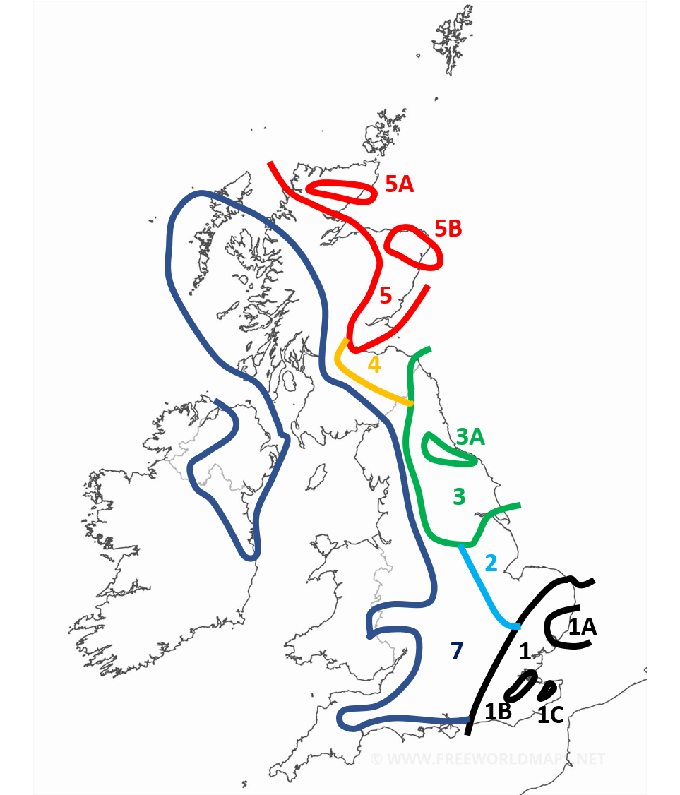
 

sundaysnowamounts-V2


Region 1: 2-7cm generally with more for the more south eastern parts of the region. Around the border expect less than 2cm. With patchy snow occasionally extending outside of the region.

Region 1A: More than 3cm with locally as much as 9cm

Region 1B: In the early afternoon the snow is expected to start banding with some convective activity enhancing the front. Locally as high as 20cm. This area in particular could get an absolute dumping.

Region 1C: Similar to 1B, enhanced snow activity expected here. With 5-10cm expected.

Region 2: Occasional snow showers but negligable amounts. During the late afternoon and evening heavy snow showers are expected particularly in the NE of the region giving 2-5cm locally. Some of the snow showers are likely to band and form streamers, though this is more of a hazard for early monday.

Region 3: Snow showers most of the day, especially mid morning onwards. Mostly light or moderate but occasionally heavy. Highly variable snow amounts. 1-5cm generally.

Region 3A: Showers expected to be concentrated and heavier around this region. 3-7cm.

Region 4: Light or moderate scattered snow showers. Smaller amounts expected here. 1-3cm

Region 5: Heavy but often scattered snow showers. Amounts highly variable. 1-10cm, higher amounts expected on higher ground and in the north of the region.

Region 5A: More frequent showers expected here. 3-10cm.

Region 5B: More frequent and sometimes heavier snow showers here. Also possibility of a streamer. 5-10cm.

Region 7 (appologies I missed out 6): Occasional snow showers. Especially later in the day, where some areas may even see some heavier snow showers. Locally up to 2cm. Mostly a dusting. Perhaps more if you include snow after dark which will become more widespread. Some snow also likely in eastern parts of the Midlands/south initially for the first few hours of Sunday which may accumulate. 

Everywhere else: Occasional snow showers still possible with wintry showers occasionally possible in the SW. Accumulations are not expected before dark, with only a dusting expected after locally.

Originally Posted by: Quantum 

Thanks!

I am just about in the hot zone! But I am not expecting that much. But what falls may stick around all week which is very unusual these days


Purley, Surrey, 70m ASL

"We have some alternative facts for you"

Kelly-Ann Conway - former special adviser to the President

Richard K
06 February 2021 21:02:34
I am roughly on the junction between 1, 2 and 7 - anything is possible!
Saffron Walden, NW Essex, approx 70m above sea level (when the tide is out)
picturesareme
06 February 2021 21:44:59
Well temperatures & especially the dewpoint's have been climbing up over the last 1.5 hours.
jhall
06 February 2021 21:48:12

Very sad we don’t have a general cold snap event thread, as we do with storms and heatwaves. Otherwise I’d put this observation in there.

Enjoying this evening’s slow, ponderous but inexorable cooling under rain. Xcweather map gradually going paler green:

https://www.xcweather.co.uk/observations

And my vineyard is 2C down from today’s peak and gradually falling:

https://www.wunderground.com/dashboard/pws/ICANTE19

Originally Posted by: TimS 

You have your own vineyard?! Not in Brockley, presumably.


Cranleigh, Surrey
Polar Low
06 February 2021 22:04:01

Both now steadily falling in Essex its on its way

https://cm2weather.co.uk/gauges


Well temperatures & especially the dewpoint's have been climbing up over the last 1.5 hours.

Originally Posted by: picturesareme 

fairweather
06 February 2021 22:05:04

Well said Caz, very frustrating when you hear the location called here all the time, with no signature/location. Also when you get snow reports in the Potential thread.

Originally Posted by: Coxy410 

Unless you've got an iphone or use a phone instead of a PC or laptop of course you wouldn't have been aware of that. So thanks Caz for poining that out I've added mine at the bottom as well now. 


S.Essex, 42m ASL
fairweather
06 February 2021 22:08:49

Looking at the way the temperature profile is and the steady movement of the heavy rain west I wouldn't be surprised to see the Cotswolds end up doing well out of this.


S.Essex, 42m ASL
Zubzero
06 February 2021 22:08:57

I am roughly on the junction between 1, 2 and 7 - anything is possible!

Originally Posted by: Richard K 

Same knowing my luck the 3 way intersection will be a snowless void...Welcome to the snowless zone enter @ your own risk ⚠⛔🚫

Polar Low
06 February 2021 22:15:12

https://meteoradar.co.uk/realtime-snowfall


 Colder air tucking in behind 


RobN
  • RobN
  • Advanced Member
06 February 2021 22:19:41


My MetO automated is still showing four hours of rain tonight followed by one hour of snow ending at 2am. After that it is cloudy and dry with the lowest temperature shown as -2C until it warms up to 5C next Friday. Memorable spell here? Not according to the MetO.

Originally Posted by: RobN 

And now my hour of snow tonight has been downgraded to sleet.


Rob

In the flatlands of South Cambridgeshire 15m ASL.

tallyho_83
06 February 2021 22:23:44

Met office now has light snow for Exeter back on the forecast for 21:00 Tuesday until 06:00 Wednesday (60% chance). - From a 30% chance this morning - it does seem marginal.
However, i notice Plymouth (S Devon) has a 60 - 70% chance of snow from 03:00 Tuesday until 09:00 on Wednesday which still has a 40% chance of snow @ 09:00 Wednesday. Daytime max which was forecast to be +3c for Tuesday 9th February is now +1c for Plymouth according to the Met Office. 

Originally Posted by: tallyho_83 

Update: Back to where we were this morning there is now only a 20% chance of precipitation at best in Exeter on Tuesday night into Wednesday morning! Come on - make you're mind up.


Home Location - Vixen Tor Close, Okehampton, Devon (221m ASL)

---------------------------------------

Sean Moon

Magical Moon

www.magical-moon.com

Polar Low
06 February 2021 22:29:12

Feeling a tad chilly at Thames sea area at the minute

Easterly gale force 8, increasing severe gale force 9 soon

WIND

Easterly or northeasterly 7 to severe gale 9.

SEA STATE

Rough or very rough.

WEATHER

Rain or snow.

VISIBILITY

Moderate, occasionally very poor. Light icing in southeast.

Low southwest France 997 expected belgium 994 by midday tomorrow. New low expected Sole 991 by same time


picturesareme
06 February 2021 22:30:47


And now my hour of snow tonight has been downgraded to sleet.

Originally Posted by: RobN 

All traces of wintry perception on the hourly have been replaced here with rain. Predictable to be honest.

BaryBazz
06 February 2021 22:54:32
Not sure if everything is being downgraded but for Harrow the Meto has gone from heavy snow for a few hours and then light snow all day tomorrow to light snow from 4am to 7am and then no snow till light snow at 2 pm. For a few hours .

Looks like my 8cm has melted already.

Remove ads from site