Please note: this is valid from midnight to midnight tommorow. Snow that falls today or early on Monday is not included.
Updated snow risk map. I haven't changed a huge amount. I stand by most of what I said before.
https://i.ibb.co/MDLLzMp/sundaysnowamounts-V2.png
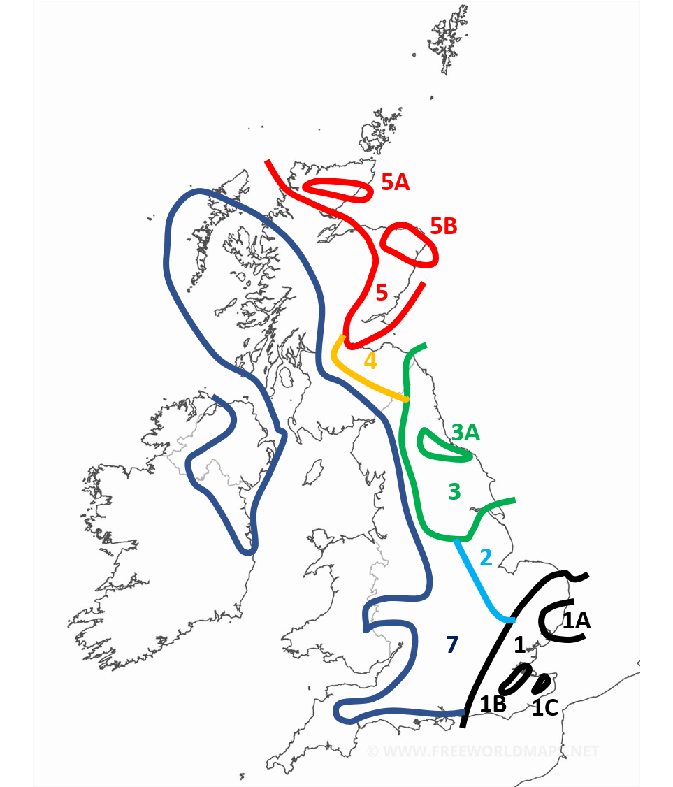
Region 1: 2-7cm generally with more for the more south eastern parts of the region. Around the border expect less than 2cm. With patchy snow occasionally extending outside of the region.
Region 1A: More than 3cm with locally as much as 9cm
Region 1B: In the early afternoon the snow is expected to start banding with some convective activity enhancing the front. Locally as high as 20cm. This area in particular could get an absolute dumping.
Region 1C: Similar to 1B, enhanced snow activity expected here. With 5-10cm expected.
Region 2: Occasional snow showers but negligable amounts. During the late afternoon and evening heavy snow showers are expected particularly in the NE of the region giving 2-5cm locally. Some of the snow showers are likely to band and form streamers, though this is more of a hazard for early monday.
Region 3: Snow showers most of the day, especially mid morning onwards. Mostly light or moderate but occasionally heavy. Highly variable snow amounts. 1-5cm generally.
Region 3A: Showers expected to be concentrated and heavier around this region. 3-7cm.
Region 4: Light or moderate scattered snow showers. Smaller amounts expected here. 1-3cm
Region 5: Heavy but often scattered snow showers. Amounts highly variable. 1-10cm, higher amounts expected on higher ground and in the north of the region.
Region 5A: More frequent showers expected here. 3-10cm.
Region 5B: More frequent and sometimes heavier snow showers here. Also possibility of a streamer. 5-10cm.
Region 7 (appologies I missed out 6): Occasional snow showers. Especially later in the day, where some areas may even see some heavier snow showers. Locally up to 2cm. Mostly a dusting. Perhaps more if you include snow after dark which will become more widespread. Some snow also likely in eastern parts of the Midlands/south initially for the first few hours of Sunday which may accumulate.
Everywhere else: Occasional snow showers still possible with wintry showers occasionally possible in the SW. Accumulations are not expected before dark, with only a dusting expected after locally.
Edited by user
06 February 2021 19:49:46
|
Reason: Not specified
25/26 (850hpa temp) 11 days snow/sleet falling
18/11 (-4) 19/11 (-6) 20/11 (-6) 01/01 (-7) 04/01 (-10) 10/01 (-7) 11/01 (-3) 30/01 (-1) 13/02 (-6) 15/02 (-4) 18/02 (-6)
24/25 10d
18/11 (-6) 19/11 (-6) 23/11 (-2) 22/12 (-5) 04/01 (-5) 05/01 (0)14/02 (0) 15/02 (0)12/03 (-6) 13/03 (-6)
23/24 8d
29/11 (-6) 30/11 (-6) 02/12 (-5) 03/12 (-5) 04/12 (-3) 16/01 (-3) 18/01 (-8)08/02 (-5)
22/23 7d
18/12 (-1)06/03 (-6) 08/03 (-8) 09/03 (-6) 10/03 (-8) 11/03 (-5) 14/03 (-6)
21/22 12d