The Weather Outlook

Remove ads from site

Joe Bloggs
06 February 2021 13:33:02


We know when we aren't important 

Originally Posted by: Gooner 

The map is only for tomorrow to be fair, the very start of the spell. πŸ˜€

SJV
06 February 2021 13:35:31


Good map for tomorrow, very good effort indeed. 

Towards Monday and Tuesday I think more central parts could be affected, e.g. places like Sheffield, Peak District etc. 


Originally Posted by: Joe Bloggs 

That's my thinking, too. Odd flurry tomorrow but signs of more organised showery precipitation from the east on Monday ❄️

Joe Bloggs
06 February 2021 13:39:10


That's my thinking, too. Odd flurry tomorrow but signs of more organised showery precipitation from the east on Monday ❄️

Originally Posted by: SJV 

A lot of it seems to be centred around the Humber estuary and a streamer forming from there. A classic pattern in an easterly. The ENE’ly will push the band through the Peak District, maybe South Yorks etc. As the flow tends to change to an easterly or even ESE’ly through Tuesday, areas further north may be affected. 

Lots of general random North Sea showers elsewhere I’d imagine. 

Quantum
  • Quantum
  • Advanced Member Topic Starter
06 February 2021 13:49:08


The map is only for tomorrow to be fair, the very start of the spell. πŸ˜€

Originally Posted by: Joe Bloggs 

Yes, also crucially doesn't include this evening where snow may fall more widely across the Midlands.


25/26 (850hpa temp) 11 days snow/sleet falling

18/11 (-4) 19/11 (-6) 20/11 (-6) 01/01 (-7) 04/01 (-10) 10/01 (-7) 11/01 (-3) 30/01 (-1) 13/02 (-6) 15/02 (-4) 18/02 (-6)

24/25 10d

18/11 (-6) 19/11 (-6) 23/11 (-2) 22/12 (-5) 04/01 (-5) 05/01 (0)14/02 (0) 15/02 (0)12/03 (-6) 13/03 (-6)

23/24 8d

29/11 (-6) 30/11 (-6) 02/12 (-5) 03/12 (-5) 04/12 (-3) 16/01 (-3) 18/01 (-8)08/02 (-5)

22/23 7d

18/12 (-1)06/03 (-6) 08/03 (-8) 09/03 (-6) 10/03 (-8) 11/03 (-5) 14/03 (-6)

21/22 12d

Retron
06 February 2021 13:52:18

You’ve undercooked Region 1c I think. IMO we will get 20-30cm

Originally Posted by: Justin W 

I'd also say my part of region 1 (sandwiched between 1b and 1c) will see a fair bit more than 2-5cm. We'll see soon enough!


Leysdown, north Kent
Gusty
06 February 2021 13:53:12

I know people like my snow MS paint maps so here are my thoughts for tommorow.

https://i.ibb.co/tMMrKTn/sundaysnowamounts.png 
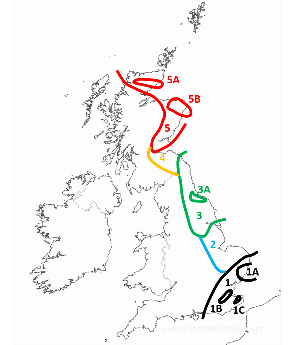


sundaysnowamounts


Region 1: 2-5cm generally with more for the more south eastern parts of the region. Around the border expect less than 2cm. With patchy snow occasionally extending outside of the region.

Region 1A: More than 3cm with locally as much as 7cm

Region 1B: In the early afternoon the snow is expected to start banding with some convective activity enhancing the front. Locally as high as 15cm

Region 1C: Similar to 1B, enhanced snow activity expected here. With 5-10cm expected.

Region 2: Occasional snow showers but negligable amounts. During the late afternoon and evening heavy snow showers are expected particularly in the NE of the region giving 2-5cm locally. Some of the snow showers are likely to band and form streamers, though this is more of a hazard for early monday.

Region 3: Snow showers most of the day, especially mid morning onwards. Mostly light or moderate but occasionally heavy. Highly variable snow amounts. 1-5cm generally.

Region 3A: Showers expected to be concentrated and heavier around this region. 3-7cm.

Region 4: Light or moderate scattered snow showers. Smaller amounts expected here. 1-3cm

Region 5: Heavy but often scattered snow showers. Amounts highly variable. 1-10cm, higher amounts expected on higher ground and in the north of the region.

Region 5A: More frequent showers expected here. 3-10cm.

Region 5B: More frequent and sometimes heavier snow showers here. Also possibility of a streamer. 5-10cm.


ADENDUM 1 (1:23pm) : I think the western extent of region 4 and region 3 in particular are a little bit too far east. Snow showers are expected to get as far west as Bradford. In region 4 some snow showers will get as far west as Glasgow.


Originally Posted by: Quantum 

I think you've undercooked Region 1 - I'm expecting 10-15cm here.


Steve - Folkestone, Kent

Current conditions from my Davis Vantage Vue

https://www.wunderground.com/dashboard/pws/IFOLKE11 

Join Kent Weather on Facebook.

https://www.facebook.com/stevewall69/ 


LeedsLad123
06 February 2021 14:03:09

Personally I expect 1-5cm to be the total we get for the entirety of this cold spell, erring to the lower amount.


Whitkirk, Leeds - 85m ASL.
BaryBazz
06 February 2021 14:15:42
Is it just me but a lot of the mobile apps seem to be reducing the amount of snow , the duration and the eastward movement to North London
Hippydave
06 February 2021 14:18:31


I think you've undercooked Region 1 - I'm expecting 10-15cm here.

Originally Posted by: Gusty 

Tricky for my little bit of West Kent. Easterlies are sometimes fickle beasts - in the sweet spot and I'd say 20+cm is entirely possible (BTFE I had 20cm, 2009 and 2010 I had circa 30cm from heavy convective snowfall that lasted ages, Feb/March 2005 I had several falls around 10-15 cm. Conversely there's been a few Easterlies where I barely scrape a covering. I think the Boxing day Easterly a few years back was a decent example of that - hillier parts of East Kent got 30cm and I got a CM or two from memory. I've also had Easterlies where the streamer sets up to the North of me and Sevenoaks has had heavy snow and I've had nothing. 

The setup to me says I'll get 10cm during Sunday and into Monday but there's always a chance I'll miss out on any streamers enhancing the snowfall and could get 2-4cm. 

I'll find out soon I guess - I've already made a pact with daughter to wake her up if it's snowing loads

Slightly OT but I've been out on the bike today and whereas sometimes it feels like it's going to snow soon, today feels like a calm mild day and if I didn't know better I'd laugh at the chances of it being cold enough to snow in 9-10 hours time!


Home: Tunbridge Wells

Work: Tonbridge

Caz
  • Caz
  • Advanced Member
06 February 2021 14:26:55

May post an update to the map this evening with the 12Z data.

I think the catogaries will be largelly the same, just some of the boundaries tweaked.


Originally Posted by: Quantum 

  I’ve been wondering when you would post your maps.  Thank you. 


Market Warsop, North Nottinghamshire.

Join the fun and banter of the monthly CET competition.

ARTzeman
06 February 2021 14:31:29

Bring it over, Storm Darcy !!!!


Some people walk in the rain.

Others just get wet.

I Just Blow my horn or trumpet

warrenb
06 February 2021 14:38:40


Tricky for my little bit of West Kent. Easterlies are sometimes fickle beasts - in the sweet spot and I'd say 20+cm is entirely possible (BTFE I had 20cm, 2009 and 2010 I had circa 30cm from heavy convective snowfall that lasted ages, Feb/March 2005 I had several falls around 10-15 cm. Conversely there's been a few Easterlies where I barely scrape a covering. I think the Boxing day Easterly a few years back was a decent example of that - hillier parts of East Kent got 30cm and I got a CM or two from memory. I've also had Easterlies where the streamer sets up to the North of me and Sevenoaks has had heavy snow and I've had nothing. 

The setup to me says I'll get 10cm during Sunday and into Monday but there's always a chance I'll miss out on any streamers enhancing the snowfall and could get 2-4cm. 

I'll find out soon I guess - I've already made a pact with daughter to wake her up if it's snowing loads

Slightly OT but I've been out on the bike today and whereas sometimes it feels like it's going to snow soon, today feels like a calm mild day and if I didn't know better I'd laugh at the chances of it being cold enough to snow in 9-10 hours time!

Originally Posted by: Hippydave 

On your OT bit. I remember one of the cold spells in the eighties that started with a day that had temps around 9c. Walked home from school through a grey damp atmosphere. Watches Michael Fish in the Schofield broom cupboard explaining it was the air high up that was cold and it would snow. Sure enough my brother came in at 6 that evening to say there were flakes in the air. Snows all light and woke up to about 12cm of snow and stayed cold for around a week.


soperman
06 February 2021 14:41:37

Is it just me but a lot of the mobile apps seem to be reducing the amount of snow , the duration and the eastward movement to North London

Originally Posted by: BaryBazz 


Not by Meto.

Most snow symbols for High Wycombe today than previous days

Sill not counting on much until later in the week - 5cm if we're lucky.

Unlikely to be a classic for the Chilterns or the Cotswolds based on the output but you never know!


Happily living by the sea in Brixham......but sad to leave the snowy Chiltern Hills after 35 years!
Gooner
06 February 2021 14:44:31

Be interesting to see who gets what 


Remember anything after T120 is really Just For Fun


Marcus

Banbury

North Oxfordshire

378 feet A S L


Gooner
06 February 2021 15:00:21

Be interesting to see who gets what 

Originally Posted by: Gooner 

Exactly the chart Louise Lear has just shown


Remember anything after T120 is really Just For Fun


Marcus

Banbury

North Oxfordshire

378 feet A S L


idj20
06 February 2021 15:04:49
<------ Sitting on chair and twiddling my thumbs waiting patiently. It's like the night before Christmas and hope I get what I've always wanted by tomorrow morning. It just would be surreal to see my first actual proper snow cover since March 2013.
Home location: Folkestone Harbour.
Whether Idle
06 February 2021 15:14:45

<------ Sitting on chair and twiddling my thumbs waiting patiently. It's like the night before Christmas and hope I get what I've always wanted by tomorrow morning. It just would be surreal to see my first actual proper snow cover since March 2013.

Originally Posted by: idj20 

Yes Ian.  It's been along wait, 2,990 days near enough, made all the more painful by the utter non event of the BFTE1 in 2018 on our corner.

Let's hope nothing will go wrong this time. - it would be the whole thing heading too far NW leaving us out of the loop so to speak.  Cant happen again, surely?


Dover, 5m asl. Half a mile from the south coast.
Gooner
06 February 2021 15:15:35

3B2205CF-326D-4F22-9840-ED79FA435BA3.jpeg

I'd take that other wise I can see my Aunt in EA needing bread and mild delivered lol 


Remember anything after T120 is really Just For Fun


Marcus

Banbury

North Oxfordshire

378 feet A S L


Easternpromise
06 February 2021 15:17:19
Latest Louise Lear forecast I recently watched, said to keep watching the forecasts as tonight's/tomorrow's main thrust of snow "may" extend further North and West. Snow graphic was shown to extend into Northern half of Norfolk and further West into the West Anglia region such as Cambridgeshire.
Location: Yaxley, Suffolk
Retron
06 February 2021 15:36:43

The 12z UKV as displayed by the MetO page seems to have conjured up a sleet symbol for noon tomorrow here. I'm sure that's just some sort of weird fluke...

It's also reduced the intensity of the snow, but that's not unexpected... I didn't really expect a whole day of heavy snow, just several hours of it (interspersed with lighter stuff).


Leysdown, north Kent
Snow Hoper
06 February 2021 15:38:41

Latest Louise Lear forecast I recently watched, said to keep watching the forecasts as tonight's/tomorrow's main thrust of snow "may" extend further North and West. Snow graphic was shown to extend into Northern half of Norfolk and further West into the West Anglia region such as Cambridgeshire.

Originally Posted by: Easternpromise 

If that was to be the case, I wonder whether it meant a heavier core of Snow would sit on the areas further eastπŸ‘€


Going to war over religion is like killing each other to see who has the better imaginary friend.

Home : Mid Suffolk.

48m Asl

Heavy Weather 2013
06 February 2021 15:39:32

The 12z UKV as displayed by the MetO page seems to have conjured up a sleet symbol for noon tomorrow here. I'm sure that's just some sort of weird fluke...

It's also reduced the intensity of the snow, but that's not unexpected... I didn't really expect a whole day of heavy snow, just several hours of it (interspersed with lighter stuff).


Originally Posted by: Retron 

Mines gone from light snow (heavy for 4hrs) all day to light snow for four hours between 3-7am


Mark

Beckton, E London

Less than 500m from the end of London City Airport runway.

Gooner
06 February 2021 15:44:52

I have noticed though on the BEEB forecast for tomorrow  the temps are shown now to be a tad up on what was being shown yesterday .


Remember anything after T120 is really Just For Fun


Marcus

Banbury

North Oxfordshire

378 feet A S L


fairweather
06 February 2021 15:46:23

The 12z UKV as displayed by the MetO page seems to have conjured up a sleet symbol for noon tomorrow here. I'm sure that's just some sort of weird fluke...

It's also reduced the intensity of the snow, but that's not unexpected... I didn't really expect a whole day of heavy snow, just several hours of it (interspersed with lighter stuff).


Originally Posted by: Retron 

I'm afraid to say there does seem to be a dilution of the snow amounts throughout the forecasts and models this morning. Last night there was talks of blizzards and drifting in the early hours of tomorrow. looking at what's happening in Scotland I don't like to see small delays. The quicker these things strike usually  the more intensity.


S.Essex, 42m ASL
Coxy410
06 February 2021 15:46:42
Where is the town called Here?, cause it seems to get used a lot in reference to snow potential.
Steve


Newborough, Cambridgeshire

Remove ads from site