The Weather Outlook

Remove ads from site

tallyho_83
28 August 2020 00:32:06

DON'T Ban me for this but just thought it was fun to look at - if only! (Low pressure to our south and HP to our north and east = 


Home Location - Vixen Tor Close, Okehampton, Devon (221m ASL)

---------------------------------------

Sean Moon

Magical Moon

www.magical-moon.com

tallyho_83
06 September 2020 10:18:34

DON'T Ban me for this but just thought it was fun to look at - if only! (Low pressure to our south and HP to our north and east = 

Originally Posted by: tallyho_83 

Again - don't ban me but two weeks on I am still seeing a re-occurring pattern within the CFS long range for easterlies with northern blocking and southerly tracking lows over December esp towards Christmas. Maybe they could be on to something? I know many will cry it's a long way out but this pattern for a blocked and cold December is persistent within the long range CFS runs!? 


Home Location - Vixen Tor Close, Okehampton, Devon (221m ASL)

---------------------------------------

Sean Moon

Magical Moon

www.magical-moon.com

tallyho_83
06 September 2020 12:17:13

The model shows the strength of zonal winds @ 10hpa to remain weaker than average:


Home Location - Vixen Tor Close, Okehampton, Devon (221m ASL)

---------------------------------------

Sean Moon

Magical Moon

www.magical-moon.com

tallyho_83
07 September 2020 11:10:17


Again - don't ban me but two weeks on I am still seeing a re-occurring pattern within the CFS long range for easterlies with northern blocking and southerly tracking lows over December esp towards Christmas. Maybe they could be on to something? I know many will cry it's a long way out but this pattern for a blocked and cold December is persistent within the long range CFS runs!? 

Originally Posted by: tallyho_83 

Yet another one  - continuing trend this: - whilst we can't take this seriously it is nice to look at...!?


Home Location - Vixen Tor Close, Okehampton, Devon (221m ASL)

---------------------------------------

Sean Moon

Magical Moon

www.magical-moon.com

Saint Snow
07 September 2020 11:17:22


My dream scenario is cold really setting in a week before Christmas and last through January. Surely we are due something decent. It’s so tiring searching for scraps and ending up with a few flakes on the back end of a cold front,

Originally Posted by: Heavy Weather 2013 


We actually got very close to that in Dec 09/Jan 10


MBY got its first settling snow the Sunday before Xmas, which was added to in the subsequent days, giving around 7-8cm, which froze and lay on the ground until the 27th (the thaw actually set in on Boxing Day evening). After a week or so of milder weather, it turned cold again and heavy snow fell on the first Tuesday back (5th), giving 15-20cm widely over much of the country. From NW England northwards, the cold kept going until late Jan - we had snow lying until nearly the end of the month, and piled-up snow on car parks, etc were still slowly melting into Feb. 

To get two amazing winter spells in consecutive winters was special.


Martin

Home: St Helens (26m asl) Work: Manchester (75m asl)

A TWO addict since 14/12/01

"How can wealth persuade poverty to use its political freedom to keep wealth in power? Here lies the whole art of Conservative politics."

Aneurin Bevan

nsrobins
07 September 2020 12:43:40


Yet another one  - continuing trend this: - whilst we can't take this seriously it is nice to look at...!?

Originally Posted by: tallyho_83 

It is as you say way too soon. The clue is in the time stamp - +2640hrs.

That’s about +2520hrs more than is typically reliable. These ultra long term models are pretty much pig fodder and that’s being kind. There are plenty of other ‘more’ reliable trend tools that are worth a look as we go towards October.


Neil

Fareham, Hampshire 28m ASL (near estuary)

Stormchaser, Member TORRO

Gooner
07 September 2020 13:22:27


My dream scenario is cold really setting in a week before Christmas and last through January. Surely we are due something decent. It’s so tiring searching for scraps and ending up with a few flakes on the back end of a cold front,

Originally Posted by: Heavy Weather 2013 

I'm with you HW , just looking at Gavs video , lack of Hurricanes currently and a failing easterly QBO aren't filling me with joy or hope at the moment ….BUT very very early days .


But in saying the above zonal winds are forecast to be weak , which can favour a sustained period of blocking 


Remember anything after T120 is really Just For Fun


Marcus

Banbury

North Oxfordshire

378 feet A S L


tallyho_83
09 September 2020 09:38:27


Again - don't ban me but two weeks on I am still seeing a re-occurring pattern within the CFS long range for easterlies with northern blocking and southerly tracking lows over December esp towards Christmas. Maybe they could be on to something? I know many will cry it's a long way out but this pattern for a blocked and cold December is persistent within the long range CFS runs!? 

Originally Posted by: tallyho_83 

Looking at the CFS long range on meteorciel.fr

A reoccurring theme for HP to go to our north and LP to our south - of course this is again just for fun!


Home Location - Vixen Tor Close, Okehampton, Devon (221m ASL)

---------------------------------------

Sean Moon

Magical Moon

www.magical-moon.com

tallyho_83
09 September 2020 09:45:52

Zonal winds @ 10hpa look set to stay weaker than average:


Home Location - Vixen Tor Close, Okehampton, Devon (221m ASL)

---------------------------------------

Sean Moon

Magical Moon

www.magical-moon.com

Gooner
09 September 2020 10:25:01


Looking at the CFS long range on meteorciel.fr

A reoccurring theme for HP to go to our north and LP to our south - of course this is again just for fun!


Originally Posted by: tallyho_83 

Sadly Tally I have seen those so many times before and we get lovely SWlies 

Lets re-visit at 120hrs eh?

But feel free to prove me wrong each week 


Remember anything after T120 is really Just For Fun


Marcus

Banbury

North Oxfordshire

378 feet A S L


Gooner
09 September 2020 10:26:04

Zonal winds @ 10hpa look set to stay weaker than average:

Originally Posted by: tallyho_83 

That certainly encourages blocking but knowing the UK the block will sit slap bang on us lol 


Remember anything after T120 is really Just For Fun


Marcus

Banbury

North Oxfordshire

378 feet A S L


tallyho_83
09 September 2020 11:52:13


Sadly Tally I have seen those so many times before and we get lovely SWlies 

Lets re-visit at 120hrs eh?

But feel free to prove me wrong each week 

Originally Posted by: Gooner 


Of course it's JFF. - Seems consistent within the longer range CFS for an easterly around Christmas or sometime in December but fun to look at - I won't take notice of this until November arrives!

What seems like a developing La Nina looks interesting, CFS models show moderate La Nina now!? - It has been a while since we last had a moderate La Nina for the winter - can't remember when the last Moderate La Nina was!?

Nice to hear from you!! Let's hope we see something different this season instead of the PV of doom and persistent record breaking zonal flow for months on end. 


Home Location - Vixen Tor Close, Okehampton, Devon (221m ASL)

---------------------------------------

Sean Moon

Magical Moon

www.magical-moon.com

CField
09 September 2020 19:09:56


Of course it's JFF. - Seems consistent within the longer range CFS for an easterly around Christmas or sometime in December but fun to look at - I won't take notice of this until November arrives!

What seems like a developing La Nina looks interesting, CFS models show moderate La Nina now!? - It has been a while since we last had a moderate La Nina for the winter - can't remember when the last Moderate La Nina was!?

Nice to hear from you!! Let's hope we see something different this season instead of the PV of doom and persistent record breaking zonal flow for months on end. 

Originally Posted by: tallyho_83 

was it 2015....lots of hoohar in the press coldest winter for 100 years....rest is history


Favourite snowstorm

Famous channel low

Dec 31st 1978

Hastings East Sussex

Foot of level snow severe drifting

Next day max temp -4 degrees Celsius

DEW
  • DEW
  • Advanced Member Topic Starter
09 September 2020 20:10:16

Let me know if I've missed any - but anyone could have initiated this


I can calculate the movements of stars, but not the madness of men - Isaac Newton

Chichester 12m asl

Whether Idle
09 September 2020 20:30:47

I see Tally likes to set the bar of expectation at suitably high levels.


Dover, 5m asl. Half a mile from the south coast.
John S2
09 September 2020 20:40:54
These charts based on data from ECMWF seem to suggest average temperatures in Dec & Jan, mild in Feb. This could mean some cold snaps in Dec/Jan, balanced by periods of milder weather. Early days at present.

https://effis.jrc.ec.europa.eu/applications/seasonal-forecast/ 

It is likely that we will have a La Nina this winter. La Nina winters sometimes have cold snaps early on, followed by calm anticyclonic February - this is not a 'rule' just a tendency.

The Indian Ocean Dipole [IOD] which was in a strongly positive state at the beginning of last winter is forecast to be either negative or neutral this coming winter.

The QBO is doing strange things at the moment and therefore can't be used as an indicator.

picturesareme
09 September 2020 21:27:27

One thing i will say is that the tree's have turned much earlier this year, and i'm not just talking of horse chestnut. If i didn't know better i would have thought it was late September rather then early. Can't blame it on the weather either as the summer has been good, and autumn so far has been very warm. 

The last time i recall the tree's turning so early (2010) we had a cold winter 

tallyho_83
09 September 2020 21:58:04


I'm with you HW , just looking at Gavs video , lack of Hurricanes currently and a failing easterly QBO aren't filling me with joy or hope at the moment ….BUT very very early days .


But in saying the above zonal winds are forecast to be weak , which can favour a sustained period of blocking 

Originally Posted by: Gooner 

Yes! What's interesting is that we have seen above average tropical activity in the Atlantic but very few hurricanes - which is unusual given how warm the SST's are in the Atlantic as a whole in general.  - Surely this is a recipe for development!?


Home Location - Vixen Tor Close, Okehampton, Devon (221m ASL)

---------------------------------------

Sean Moon

Magical Moon

www.magical-moon.com

Retron
10 September 2020 03:50:30

One thing i will say is that the tree's have turned much earlier this year,

Originally Posted by: picturesareme 

A few have here, but that's due to drought stress - what rain we've had over the past few months has been either so light as to not do anything, or heavy enough to sluice straight across the land and into the drains / steams.


Leysdown, north Kent
Rob K
10 September 2020 08:37:20

One thing i will say is that the tree's have turned much earlier this year, and i'm not just talking of horse chestnut. If i didn't know better i would have thought it was late September rather then early. Can't blame it on the weather either as the summer has been good, and autumn so far has been very warm. 

The last time i recall the tree's turning so early (2010) we had a cold winter 

Originally Posted by: picturesareme 

I think autumn has generally started earlier and the dry conditions may well be to blame, not just the leaves but the fruit. Our blackberries are already finished, and the sloes have been out in force for weeks.


Yateley, NE Hampshire, 73m asl

"But who wants to be foretold the weather? It is bad enough when it comes, without our having the misery of knowing about it beforehand." — Jerome K. Jerome

tallyho_83
10 September 2020 10:06:24


Yes! What's interesting is that we have seen above average tropical activity in the Atlantic but very few hurricanes - which is unusual given how warm the SST's are in the Atlantic as a whole in general.  - Surely this is a recipe for development!?

Originally Posted by: tallyho_83 

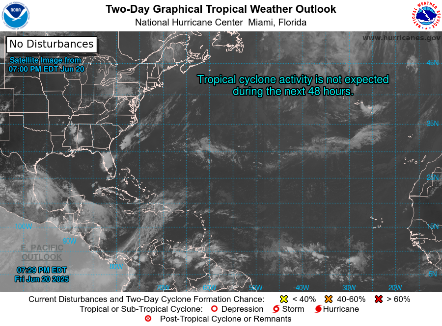
So far from NOAA - Looks like things will really begin to live up, but as per above given how warm the SST's are in the Atlantic as a whole esp the N. Atlantic I am surprised none of these tropical depressions or disturbances or tropical storms are forecast to become a hurricane, they seem to disintegrate and fragment!? - Why is this? Due to the HP positioning? Wind sheer? 

In September 2017 there was at least three hurricanes in the Atlantic the same week . After Harvey there was Irma in September 2017 which hit Florida as a Major Cat 3/4 Hurricane, then there was Jose and then Katia, then there was Lee followed by Maria a Cat 5 - I remember that one, then Nate formed and then Ophelia - which we all remember! Most if not all were major Hurricanes. This year we haven't had a major hurricane in Atlantic - int he Gulf yes but not in Atlantic. That really active tropical season with major hurricanes in the Atlantic gave us southerly tracking lows in January and eventually extensive northern blocking in February as we can all remember it lead to the beast from the east. - with help by the SSW but I think there is a connection between Hurricanes and High latitude blocking throughout the winter months.

Home Location - Vixen Tor Close, Okehampton, Devon (221m ASL)

---------------------------------------

Sean Moon

Magical Moon

www.magical-moon.com

tallyho_83
10 September 2020 10:40:07


So far from NOAA - Looks like things will really begin to live up, but as per above given how warm the SST's are in the Atlantic as a whole esp the N. Atlantic I am surprised none of these tropical depressions or disturbances or tropical storms are forecast to become a hurricane, they seem to disintegrate and fragment!? - Why is this? Due to the HP positioning? Wind sheer? 

In September 2017 there was at least three hurricanes in the Atlantic the same week . After Harvey there was Irma in September 2017 which hit Florida as a Major Cat 3/4 Hurricane, then there was Jose and then Katia, then there was Lee followed by Maria a Cat 5 - I remember that one, then Nate formed and then Ophelia - which we all remember! Most if not all were major Hurricanes. This year we haven't had a major hurricane in Atlantic - int he Gulf yes but not in Atlantic. That really active tropical season with major hurricanes in the Atlantic gave us southerly tracking lows in January and eventually extensive northern blocking in February as we can all remember it lead to the beast from the east. - with help by the SSW but I think there is a connection between Hurricanes and High latitude blocking throughout the winter months.

Originally Posted by: tallyho_83 

Of course there were other factors that lead to a slightly cooler than average winter such as the strong easterly QBO, and the weak La Nina. But again the winter as a whole 2017/18 was only -0.2 below average as most of the colder weather wasn't until the very end of it.


Home Location - Vixen Tor Close, Okehampton, Devon (221m ASL)

---------------------------------------

Sean Moon

Magical Moon

www.magical-moon.com

picturesareme
10 September 2020 11:30:42


I think autumn has generally started earlier and the dry conditions may well be to blame, not just the leaves but the fruit. Our blackberries are already finished, and the sloes have been out in force for weeks.

Originally Posted by: Rob K 

I see retron also mentioned it but hasn't been that dry here.. certainly nothing unusual. July was dry yes but a dry 3 or 4 week spell in summer here is far from unusual, and August saw plenty of rain but also lots of heat & sun. 

Walking in the forest just to the north of here in the last week of August there were two patches of beech trees that had shed a lot green leaves. This is very odd but i thought the intense heat of a couple weeks earlier or the storms a week or so before might have played a part. 

What i'm seeing now though are widespread leaf colour change even here within the city. The grass is nice green.

Sloe to here are looking plump and some of the hedges have begun to die back. No issues with blackberries, but Hazelnuts have been and gone.

idj20
10 September 2020 15:22:43

Is this the record for the earliest snow ramp? 


Home location: Folkestone Harbour.
AJ*
  • AJ*
  • Advanced Member
11 September 2020 08:34:47

Is this the record for the earliest snow ramp? 

Originally Posted by: idj20 

Very likely.


Angus; one of the Kent crew on TWO.

Tonbridge, 40m (131ft) asl

Remove ads from site