doctormog
19 August 2017 17:00:19

Originally Posted by: NickR 

Does anyone have a link where I can look at the GFS ens for other parts of Europe?


I think you can just type in the location for many places on this page http://www.wetterzentrale.de/de/show_diagrams.php?model=gfs&var=2&lid=ENS&h=0 


You can also click on the location in the map at this link http://www.meteociel.fr/modeles/gefs.php?carte=1 


Or, if you know the co-ordinates, you can change the following URL http://meteociel.fr/cartes_obs/gens_display.php?ext=1&lat=57.2&lon=-2.3 


Brian Gaze
19 August 2017 17:01:05

Originally Posted by: NickR 

Does anyone have a link where I can look at the GFS ens for other parts of Europe?


The TWO link is:


http://www.theweatheroutlook.com/twodata/gefs-map-selector.aspx


Brian Gaze
Berkhamsted
TWO Buzz - get the latest news and views 
"I'm not socialist, I know that. I don't believe in sharing my money." - Gary Numan
David M Porter
19 August 2017 18:10:27

Originally Posted by: severnside 


GEM looking good for B/H, can it be relied on ?


http://www.wetterzentrale.de/en/topkarten.php?map=1&model=gem&var=1&time=96&run=12&lid=OP&h=0&mv=0&tr=12


http://www.wetterzentrale.de/en/topkarten.php?map=1&model=gem&var=1&time=96&run=12&lid=OP&h=0&mv=0&tr=12


http://www.wetterzentrale.de/en/topkarten.php?map=1&model=gem&var=1&time=96&run=12&lid=OP&h=0&mv=0&tr=12


Only a week away and all the models not nailing anything down


There has been much inconsistency among the models all summer from what I've seen, but they seem to have almost lost the plot since ex-storm Gert got in on the act. As far as I'm concerned, the middle of next week is as far as we can look ahead right now with any degree of certainty, although even that range might be pushing it a bit just now.


Lenzie, Glasgow

"Let us not take ourselves too seriously. None of us has a monopoly on wisdom, and we must always be ready to listen and respect other points of view."- Queen Elizabeth II 1926-2022
Whether Idle
19 August 2017 19:11:52

GFS his res suggests Very warm for some on Tuesday when it is forecast to be south centred and again on Wednesday when the east is heat central.


Dover, 5m asl. Half a mile from the south coast.
Hungry Tiger
19 August 2017 20:07:36

Originally Posted by: Saint Snow 


Well the far reaches of FI for the 6z are actually lovely - in fact, close to perfection for summer - so long-term unreliability in this case is not a salvation!


Phew and thats nice and great timing as well.


You can't beat a decent September hot spell.


Gavin S. FRmetS.
TWO Moderator.
Contact the TWO team - [email protected]
South Cambridgeshire. 93 metres or 302.25 feet ASL.


Whether Idle
20 August 2017 06:25:45

UKMO at 144 threatens a high building in  from the west


Dover, 5m asl. Half a mile from the south coast.
Whether Idle
20 August 2017 21:14:06

ECM 12z a good summer-like run with a warm Tuesday and Wednesday and warming up from next Saturday thereafter.  Bank.  All change on the 0z I suspect


Anyhow, here's the upper air chart for day 8, Bank Holiday Monday:


The 12z GEFS for London are indicative of the massive uncertainty that sets in at around 144 hours or next Saturday: Hence my scepticism above.


Dover, 5m asl. Half a mile from the south coast.
Jiries
20 August 2017 21:40:39

Even with the warm spell coming on Tue-Wed I still cannot get excited or interested due to the damage done by the prolonged unsettled weather and everything in sorry state now.  Was brilliant in May to mid-July and if the models offering 2 days warm wonder, sorry i am out. I prefer several sunny days prior to hot spell with proper dry ground condition so look like a dirty damp warmth after tonight rain.  At least Gert had brought some temps to mid 20's that we haven't see it since mid-July.  Usually the hurricane season often good news for us to end the southern blocking and bring back northern blocking with lot of HP over us and to the East that bringing lovely warm air from Europe by September.

Whether Idle
21 August 2017 05:47:32

UKMO still keen on a warming weekend and possibly a cracking August BHM to follow. I imagine there is yet to be cross model agreement though, so not pinning hopes, just posting possibilities.


Dover, 5m asl. Half a mile from the south coast.
severnside
21 August 2017 11:09:11

I agree, the GFS is looking unsettled while others pointing to a fairly decent B/H, only 4 days away now, really suprised nothing nailed though.

Matty H
21 August 2017 11:23:45

Originally Posted by: severnside 


I agree, the GFS is looking unsettled while others pointing to a fairly decent B/H, only 4 days away now, really suprised nothing nailed though.


Im not at all surprised. The models are hopeless beyond a few days in isolation. In my opinion model accuracy beyond 5 days hasn't improved a jot since I've been viewing them online. 


David M Porter
21 August 2017 15:05:01

Originally Posted by: Matty H 


Im not at all surprised. The models are hopeless beyond a few days in isolation. In my opinion model accuracy beyond 5 days hasn't improved a jot since I've been viewing them online. 


They've certainly been all over the place at times this summer, Matty. Take what happened just over a month ago for example when it seemed for a while that there was cross-model agreement for an almost countrywide settled spell in late July, and then the sudden and dramatic flip that occured when the models picked up on the thundery low to the south. The way they have handled ex-storm Gert and how it will affect our weather this week hasn't been great either. Originally the models showed Gert as quite a potent LP system crossing the UK and was at first shown to have cleared the country by the end of the day tomorrow. Now it is a much less potent system than the models first indicated and it looks like it will be the end of the week before it has fully cleared to the east.


Lenzie, Glasgow

"Let us not take ourselves too seriously. None of us has a monopoly on wisdom, and we must always be ready to listen and respect other points of view."- Queen Elizabeth II 1926-2022
Gandalf The White
21 August 2017 17:00:58

Originally Posted by: Matty H 


Im not at all surprised. The models are hopeless beyond a few days in isolation. In my opinion model accuracy beyond 5 days hasn't improved a jot since I've been viewing them online. 


I think the evidence says there has been a little improvement but at 5 days out you're absolutely right that, as always, you need cross-model agreement and consistency.


I would say that the accuracy charts show a worse performance in the northern hemisphere summer.  I think this was put down to the generally weaker jet and the related greater uncertainties in LP development and track.


Location: South Cambridgeshire
130 metres ASL
52.0N 0.1E


Whether Idle
21 August 2017 17:31:56

GEM 144:


UKMO 144:


GFS144:


Dover, 5m asl. Half a mile from the south coast.
Gandalf The White
21 August 2017 19:11:33

Originally Posted by: Whether Idle 


GEM 144:


UKMO 144:


GFS144:


Here's ECM for comparison: close to UKMO;  both have a more pronounced but narrow ridge.   GEM looks out on its own with such a strong high pressure cell.


Location: South Cambridgeshire
130 metres ASL
52.0N 0.1E


Whether Idle
21 August 2017 19:15:26

Originally Posted by: Gandalf The White 


Here's ECM for comparison: close to UKMO;  both have a more pronounced but narrow ridge.   GEM looks out on its own with such a strong high pressure cell.


Yes, saw that, a similar picture to UKMO.  Gives some meagre hope at least for a half decent end to the month for some.


Dover, 5m asl. Half a mile from the south coast.
David M Porter
21 August 2017 20:17:12

Originally Posted by: Whether Idle 


GEM 144:


UKMO 144:


GFS144:


GEM looks good! Just unfortunate that it's not backed up by the other models at that range.


Lenzie, Glasgow

"Let us not take ourselves too seriously. None of us has a monopoly on wisdom, and we must always be ready to listen and respect other points of view."- Queen Elizabeth II 1926-2022
Whether Idle
23 August 2017 05:51:09

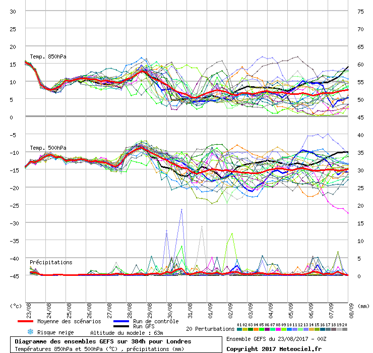
Well well, the GFS has corrected its nightmare bank holiday charts, and is producing something more akin to what the UKMO was showing a couple of days ago.  Not only this, but I note the GEFS (which seem to be very volatile beyond day 6) have also settled into -for London at least-  a dry and warm picture for most of the last week of August.  Hurrah! September is looking decidedly dodgy on this set. 


Here are the forecast maxes for the bank holiday- a decent day is possible for the majority of England south of the Humber, and a Bank holiday special for Richard in Aberdeen.


Dover, 5m asl. Half a mile from the south coast.
Saint Snow
23 August 2017 10:10:04

The 0z charts less promising for the BH weekend - especially for those away from the south-eastern third of the UK, as the low to our north-west comes into play more.


Very disappointing after it seemed our fortunes may have been picking up to deliver at least a dry and mainly sunny, although not especially warm, few days.


Bugger.


Martin
Home: St Helens (26m asl) Work: Manchester (75m asl)
A TWO addict since 14/12/01
"How can wealth persuade poverty to use its political freedom to keep wealth in power? Here lies the whole art of Conservative politics."
Aneurin Bevan
Users browsing this topic

Ads