The Weather Outlook

Remove ads from site

fairweather
04 July 2026 01:09:17

What do you think you’re missing? That’s what the models have been showing - a high 20s to low 30s spell for the south but with notable longevity. 

Having said that, the latest 12Z shows the school holiday effect and is the first properly unsettled run for a long time. 

Originally Posted by: Rob K 

Sorry, I must have imagined the posts of 45C !


S.Essex, 42m ASL
DEW
  • DEW
  • Advanced Member
04 July 2026 06:09:52
FAX - High Pressure never far from Cornwall this week, ca 1025mb, light westerly further north with fronts drifting across Scotland.

GFS Op 0z - moves the HP to the N Sea by Fri 10th, changing winds to a southerly and bringing shallow LP up from France. That LP sticks around over the weekend as pressure rises to the NW of Scotland and easterlies dominate by Tue 14th but as the LP links to larger area of LP over Scandinavia, cooler air comes in from the north Sat 18th

ECM to T +240 - similar evolution but the shallow LP only affects the S coast and the rise of pressure covers not only Scotland but the north of England as well

AIFS - London maxima rising to 31C Thu 9th then dropping to low 20s over the following week; some rain and 25C from Fri 17th. Edinburgh, mostly high teens but a warmer spell 23C around Thu 9th and again Thu 16th; light rain now and Sat 18th

GEFS - temps slowly rise to 7C above norm in S, 5C in N, by Fri 10th and slowly drop back again, fairly good ens agreement. Chances of rain generally after Fri 10th, more likely in N and in far north never really goes away.


War is God's way of teaching Americans geography - Ambrose Bierce

Chichester 12m asl

Retron
04 July 2026 06:42:09
It's going without much comment locally, but I'm amazed at the length and persistence of the heat we've had and will have. It didn't even cool down to average here (the coldest days in the past week both went above 24C), and the MetO raw ramps things up: 28 today and tomorrow, then between 30 and 32 every day for the next 5 days. That effortlessly beats 1976 (which had all of 4 days here reaching 30). GFS is very similar too, so there's high confidence in the outlook.

Another way of looking at it is the anomalies are between +6 and +10 for the next week, hot to very hot.


Leysdown, north Kent
Rob K
04 July 2026 06:47:32

Sorry, I must have imagined the posts of 45C !

Originally Posted by: fairweather 

Those were only ever isolated model runs, the mean output has always suggested low 30s as the likely peak. I think we’ll still see the crazy runs for a while yet though with this setup. 


Yateley, NE Hampshire, 73m asl

"But who wants to be foretold the weather? It is bad enough when it comes, without our having the misery of knowing about it beforehand." — Jerome K. Jerome

bledur
04 July 2026 07:58:45

It's going without much comment locally, but I'm amazed at the length and persistence of the heat we've had and will have. It didn't even cool down to average here (the coldest days in the past week both went above 24C), and the MetO raw ramps things up: 28 today and tomorrow, then between 30 and 32 every day for the next 5 days. That effortlessly beats 1976 (which had all of 4 days here reaching 30). GFS is very similar too, so there's high confidence in the outlook.

Another way of looking at it is the anomalies are between +6 and +10 for the next week, hot to very hot.

Originally Posted by: Retron 

That's way out of order . NOTHING beats 76.😜

Polar Low
04 July 2026 08:22:08

It's going without much comment locally, but I'm amazed at the length and persistence of the heat we've had and will have. It didn't even cool down to average here (the coldest days in the past week both went above 24C), and the MetO raw ramps things up: 28 today and tomorrow, then between 30 and 32 every day for the next 5 days. That effortlessly beats 1976 (which had all of 4 days here reaching 30). GFS is very similar too, so there's high confidence in the outlook.

Another way of looking at it is the anomalies are between +6 and +10 for the next week, hot to very hot.

Originally Posted by: Retron 

The one thing I can’t get my head around is the fact it reached 24c here with a quite a N westerly breeze.

Identical charts 30 years ago would have been some what less such a incredible increase in temperatures in short a short time I’m sure when GW was first mentioned it was expected to take many decades to have the same affect.

The Beast from the East
04 July 2026 09:26:06
GFS still picking the wet potential for later next week, but not on ECM
Purley, Surrey, 70m ASL

"We have some alternative facts for you"

Kelly-Ann Conway - former special adviser to the President

The Beast from the East
04 July 2026 09:29:02

The one thing I can’t get my head around is the fact it reached 24c here with a quite a N westerly breeze.

Identical charts 30 years ago would have been some what less such a incredible increase in temperatures in short a short time I’m sure when GW was first mentioned it was expected to take many decades to have the same affect.

Originally Posted by: Polar Low 

I remember when 22c 72f was considered normal july temp for London.   Nowadays that would be described as chilly!


Purley, Surrey, 70m ASL

"We have some alternative facts for you"

Kelly-Ann Conway - former special adviser to the President

Ally Pally Snowman
04 July 2026 09:52:58
Looks like multiple 30c + days starting Monday.  5 to 10 maybe more possible. 
Bishop's Stortford 85m ASL.
Retron
04 July 2026 10:19:26

I remember when 22c 72f was considered normal july temp for London.   Nowadays that would be described as chilly!

Originally Posted by: The Beast from the East 

Yes, the 61-90 average high for Kew was 22.5, now it's 23.8 - and Faversham, my local station, has gone from 21.2 to 23.1 - almost a 2C rise in only 30 years.

30+, as the models show down here, still meets the "hot" threshold (i.e. 6 or more above), but probably not for that much longer!


Leysdown, north Kent
Ally Pally Snowman
04 July 2026 10:30:26
Ridiculously hot GFS 6z multiple 100f days end of next week.
Bishop's Stortford 85m ASL.
Bertwhistle
04 July 2026 12:56:18

Ridiculously hot GFS 6z multiple 100f days end of next week.

Originally Posted by: Ally Pally Snowman 

Yep and 30s here every day from tomorrow to the end of time.


Bertie, Itchen Valley.

Retire while you can still press the 'retire now' button.

lanky
04 July 2026 13:26:19

I remember when 22c 72f was considered normal july temp for London.   Nowadays that would be described as chilly!

Originally Posted by: The Beast from the East 

24.7 is the "new normal" nowadays for average July Max's compared to 21-22C from 1960-70

a rise of about 3C since 1960's

UserPostedImage


Martin

Richmond, Surrey

Ally Pally Snowman
04 July 2026 13:37:44
GFS 6z in all its glory 

29c, 30c, 32c, 33c, 35c, 35c, 38c, 39c, 37c, 38c, 38c, 40c, 40c, 38c, 32c, 33c


Bishop's Stortford 85m ASL.
Retron
04 July 2026 13:54:24
From one extreme to another - today's 6z and yesterday's 12z GEFS, with the op in black:

https://images.meteociel.fr/im/62/13230/graphe_ens3kxr5.php.png 

https://images.meteociel.fr/im/19/23754/graphe_ens3bao0.php.png 

UserPostedImageUserPostedImage


Leysdown, north Kent
Rob K
04 July 2026 14:24:37

From one extreme to another - today's 6z and yesterday's 12z GEFS, with the op in black:

https://images.meteociel.fr/im/62/13230/graphe_ens3kxr5.php.png 

https://images.meteociel.fr/im/19/23754/graphe_ens3bao0.php.png 

UserPostedImageUserPostedImage

Originally Posted by: Retron 

Looks like quite a drop in the average temperature today despite a much hotter op run.  


Yateley, NE Hampshire, 73m asl

"But who wants to be foretold the weather? It is bad enough when it comes, without our having the misery of knowing about it beforehand." — Jerome K. Jerome

Heavy Weather 2013
04 July 2026 15:07:49

Looks like quite a drop in the average temperature today despite a much hotter op run.  

Originally Posted by: Rob K 

The irony of course is 850s still average +10. Just shows how utterly crazy this summer has been so far.


Mark

Beckton, E London

Less than 500m from the end of London City Airport runway.

Rob K
04 July 2026 18:03:41
12Z GFS gives 13 consecutive 30C+ days from tomorrow. Even though it looks like the HP breaks down!

And incidentally the mean maximum of the last 19 days (including today) is already over 30C. So that would be a full month with a mean max of 30C.


Yateley, NE Hampshire, 73m asl

"But who wants to be foretold the weather? It is bad enough when it comes, without our having the misery of knowing about it beforehand." — Jerome K. Jerome

Rob K
04 July 2026 19:00:48
The ensembles still don't want to drop the mega hot scenarios - 13 runs plus the op run hit 20C at 850mb in London on the 12Z.
Yateley, NE Hampshire, 73m asl

"But who wants to be foretold the weather? It is bad enough when it comes, without our having the misery of knowing about it beforehand." — Jerome K. Jerome

04 July 2026 19:37:06

GFS 6z in all its glory 

29c, 30c, 32c, 33c, 35c, 35c, 38c, 39c, 37c, 38c, 38c, 40c, 40c, 38c, 32c, 33c

Originally Posted by: Ally Pally Snowman 

🤣 is that 2 weeks of over 90f maxes and a possible 8 days of 100f maxes in old money..

Looks like here in Cumberland we will be having a classic Strathclyde summer 16c drizzle and gales Mon, Tuesday while South and East of here will bake.  Hopefully fully join in by Thursday. 

Polar Low
04 July 2026 20:27:42

I remember when 22c 72f was considered normal july temp for London.   Nowadays that would be described as chilly!

Originally Posted by: The Beast from the East 

Hi Geoff, They used to change the weather symbol to an orange colour in the seventies when it reached 25c which meant it was going to a top end summer day.

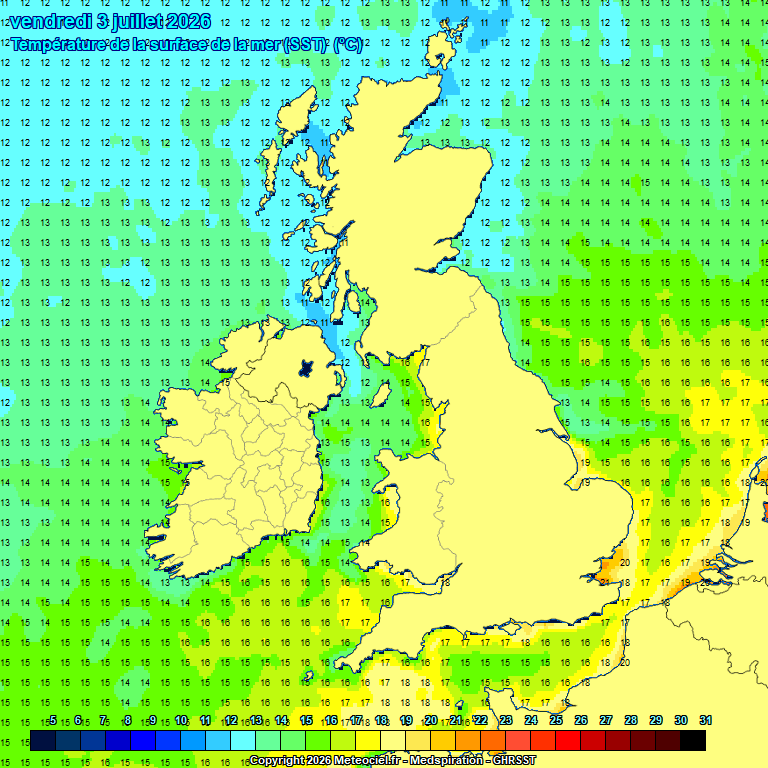
Now they don’t bother as most days in se and London are above 25c without any special conditions or uppers in fact even when not really favourable I also note amazing sst around the south coast these days .

Retron
05 July 2026 03:34:26

Looks like here in Cumberland we will be having a classic Strathclyde summer 16c drizzle and gales Mon, Tuesday while South and East of here will bake.  Hopefully fully join in by Thursday. 

Originally Posted by: HighPressureGloom 

In all seriousness, you should make the most of that livable weather while you can - I wish I had in the 80s! Living in a house that gets hotter day by day until the very bricks and floors radiate warmth, making sleep fleeting, sweat common, is something I don't think people appreciate until they have to endure it. Even the heat fans locally to me seem to be struggling by night...

I also note amazing sst around the south coast these days .

Originally Posted by: Polar Low 

The Thames estuary knocks those south coast SSTs into a cocked hat. It's been in the low 20s for a couple of weeks now and the warmth is spreading ever further out. Considering it used to peak at say 17 or 18 in September it really is remarkable. It also makes the nights that much warmer when the wind blows from the sea, which then means the days will be hotter... a reinforcing cycle.

https://images.meteociel.fr/im/80/7846/2026_07_03ukoiu5.gif 
UserPostedImage

The most staggering thing for me is the way people in general don't seem to realise how exceptional this weather is - I swear if it's not high 20s people seem to be disappointed these days. People don't seem to believe you when you say the average is 22 or 23 this time of year!


Leysdown, north Kent
Heavy Weather 2013
05 July 2026 04:22:33

In all seriousness, you should make the most of that livable weather while you can - I wish I had in the 80s! Living in a house that gets hotter day by day until the very bricks and floors radiate warmth, making sleep fleeting, sweat common, is something I don't think people appreciate until they have to endure it. Even the heat fans locally to me seem to be struggling by night...

The Thames estuary knocks those south coast SSTs into a cocked hat. It's been in the low 20s for a couple of weeks now and the warmth is spreading ever further out. Considering it used to peak at say 17 or 18 in September it really is remarkable. It also makes the nights that much warmer when the wind blows from the sea, which then means the days will be hotter... a reinforcing cycle.

https://images.meteociel.fr/im/80/7846/2026_07_03ukoiu5.gif 

UserPostedImage

The most staggering thing for me is the way people in general don't seem to realise how exceptional this weather is - I swear if it's not high 20s people seem to be disappointed these days. People don't seem to believe you when you say the average is 22 or 23 this time of year!

Originally Posted by: Retron 

The shift during the last 8 years has been remarkable.

During last heatwave when looking at max records, I noticed the minimum records and all of them are very old records - were unlikely to see them broken in our lifetimes again.


Mark

Beckton, E London

Less than 500m from the end of London City Airport runway.

DEW
  • DEW
  • Advanced Member
05 July 2026 06:28:20
FAX - keeps HP in the Channel with reinforcements from the SW by Thu 9th 1020-1025mb, fronts still plaguing Scotland

GFS Op 0z - After FAX charts end, pressure drops and LP drifts north from France and into the N Sea while a new ridge of HP forms from the SW across Scotland by Mon 13th , staying there with light E/NE-lies for England until the ridge topples SE-wards Tue 21st. (No sign of yesterday's predicted school holiday breakdown)

ECM to T +240 - like GFS but the ridge of HP shifts S-wards as early as Tue 14th while N Scotland gets fresh W-lies from LP 995mb Iceland.

AIFS (easy-read wetterzentrale version not loading, this from ECMWF) - London, maxima reaching 33C by Fri 10th, dropping to 26C Tue 14th, maybe a little rain after Sat 11th. Edinburgh, mostly near 18-21C, warmer  around Thu 9th (24C), some rain in the next few days and again after the weekend, a lot of cloud cover

GEFS - a steady rise of mean temp to a plateau around 8C above norm for England  Fri 10th or 6C above norm for Scotland  Thu 9th dropping back to norm Sun 19th, good ens support. . Very little rain for England, chance of a little in a week or so's time, more definite for Scotland Fri 11th and after Wed 15th (plus a little now in the far N)


War is God's way of teaching Americans geography - Ambrose Bierce

Chichester 12m asl

Crepuscular Ray
05 July 2026 07:31:24
Meanwhile, away from the hot south, the 3 main 00Z models continue to show a damp cloudy Atlantic influence for the north, maybe 17 - 23 C maximum's, always slightly warmer towards the east

From Wednesday onwards, there is some hope that pressure rises further north, eventually the High could move to northern Scotland. Northern Ireland, Northern England and Scotland could have sunshine at last and it should be dry. Maximum temperatures 20 - 25 C though a heatwave still unlikely for Scotland

Meanwhile the south roasts! The models appear to show a continuation of the heat for the Midlands, south Wales and southern England. Heatwave No 3 with maximum's 27 - 34 C and warm nights 😲


Jerry

Edinburgh, in the frost hollow below Blackford Hill

Remove ads from site