TimS
  • TimS
  • Advanced Member Topic Starter
20 June 2019 06:31:00

Will the continent hit 40C? Will the pinks make it across the channel to us? Will it all end in a bang? Or will we just get a brief glancing blow?


GFS for next Thursday:


Brockley, South East London 30m asl
Ally Pally Snowman
20 June 2019 08:38:35

Ecm means remain high for the SE until 216h. Very hot overall 


Bishop's Stortford 85m ASL.
Saint Snow
20 June 2019 09:10:57

Not sure high temps will make it up here, but it's looking a better bet than it did yesterday, as the high looks better positioned to benefit more of the UK.


I just hope we have a good July and [especially] August


Martin
Home: St Helens (26m asl) Work: Manchester (75m asl)
A TWO addict since 14/12/01
"How can wealth persuade poverty to use its political freedom to keep wealth in power? Here lies the whole art of Conservative politics."
Aneurin Bevan
Heavy Weather 2013
20 June 2019 10:09:43

06z so far looking just as hot and a little more settled!


http://www.wetterzentrale.de/maps/GFSOPEU06_156_2.png


Mark
Beckton, E London
Less than 500m from the end of London City Airport runway.
Rob K
20 June 2019 10:28:26
Automated output in my phone seems to have caught up to this suddenly. Yesterday the highest it was showing for London next week was 26C. This morning it has 31C, 32C, 33C, 31C for Monday to Thursday! Then back down to 18C by Saturday.
Yateley, NE Hampshire, 73m asl
"But who wants to be foretold the weather? It is bad enough when it comes, without our having the misery of knowing about it beforehand." — Jerome K. Jerome
Essan
20 June 2019 10:37:54

Most of England and Wales now under a yellow warning for thunderstorms from Sunday PM though Monday

Meanwhile, the Met Office not-a-forecast is predicting temperatures as high as 22c next week in Evesham


Andy
Evesham, Worcs, Albion - 35m asl
Weather & Earth Science News 

Anyone who is capable of getting themselves made President should on no account be allowed to do the job - DNA
Caz
  • Caz
  • Advanced Member
20 June 2019 10:37:54

Originally Posted by: Rob K 

Automated output in my phone seems to have caught up to this suddenly. Yesterday the highest it was showing for London next week was 26C. This morning it has 31C, 32C, 33C, 31C for Monday to Thursday! Then back down to 18C by Saturday.

My standard phone app has as well, but the BBC and Met Office ones haven’t changed except to issue thunder warnings from Sunday. 


Market Warsop, North Nottinghamshire.
Join the fun and banter of the monthly CET competition.
Heavy Weather 2013
20 June 2019 10:40:03

Originally Posted by: Caz 


My standard phone app has as well, but the BBC and Met Office ones haven’t changed except to issue thunder warnings from Sunday. 


Yup, everyone in office got excited despite my forecast yesterday when they said it wont happen here LOL


Mark
Beckton, E London
Less than 500m from the end of London City Airport runway.
Caz
  • Caz
  • Advanced Member
20 June 2019 10:49:37

Originally Posted by: Heavy Weather 2013 


Yup, everyone in office got excited despite my forecast yesterday when they said it wont happen here LOL


  Don’t you feel smug when you forecast something a day or two ahead of official forecasts!  Not that I can read charts, I just repeat what I read on here!  Although I never say anything’s definite, I cover myself by saying things such as, ‘it looks like next week could get quite hot if the models are right’.    


Anyway, let’s not congratulate ourselves until it happens!  As yet it still ‘looks like......etc’. 


Market Warsop, North Nottinghamshire.
Join the fun and banter of the monthly CET competition.
Heavy Weather 2013
20 June 2019 10:52:42

Originally Posted by: Caz 


  Don’t you feel smug when you forecast something a day or two ahead of official forecasts!  Not that I can read charts, I just repeat what I read on here!  Although I never say anything’s definite, I cover myself by saying things such as, ‘it looks like next week could get quite hot if the models are right’.    


Anyway, let’s not congratulate ourselves until it happens!  As yet it still ‘looks like......etc’. 


Oh I do - I have a friend who reads this forum but doesn't post. He always has to keep me in line as I often go a bit Daily Express. 


Mark
Beckton, E London
Less than 500m from the end of London City Airport runway.
Arcus
20 June 2019 15:32:03
Surprised no-one has posted the official MetO press release:


https://www.metoffice.gov.uk/about-us/press-office/news/weather-and-climate/2019/hot-spell 


Ben,
Nr. Easingwold, North Yorkshire
30m asl
Quantum
20 June 2019 15:38:13

Seems like these very high upper air temperatures are tempered by a rather high moisture content. Can possibly see some inversion type conditions developing as those hot winds are modified by the english channel and north sea. Potentially cloudy and foggy coastlines with warmth inland but also the potential for some convective instability further west too.


Twitter: @QuantumOverlord (general), @MedicaneWatch (medicane/TC stuff)
2023/2024 Snow days (approx 850hpa temp):
29/11 (-6), 30/11 (-6), 02/12 (-5), 03/12 (-5), 04/12 (-3), 16/01 (-3), 18/01 (-8), 08/02 (-5)

Total: 8 days with snow/sleet falling.

2022/2023 Snow days (approx 850hpa temp):

18/12 (-1), 06/03 (-6), 08/03 (-8), 09/03 (-6), 10/03 (-8), 11/03 (-5), 14/03 (-6)

Total: 7 days with snow/sleet falling.

2021/2022 Snow days (approx 850hpa temp):

26/11 (-5), 27/11 (-7), 28/11 (-6), 02/12 (-6), 06/01 (-5), 07/01 (-6), 06/02 (-5), 19/02 (-5), 24/02 (-7), 30/03 (-7), 31/03 (-8), 01/04 (-8)
Total: 12 days with snow/sleet falling.
richardabdn
20 June 2019 17:09:39

Next week looks totally dire. After the significant improvement this week, it looks like a return to cloud, rain and below average temperatures


Aberdeen: The only place that misses out on everything


2023 - The Year that's Constantly Worse than a Bad November
Bertwhistle
20 June 2019 17:23:07

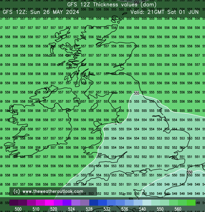
 Not sure why Richard's moaning- or anyone else for that matter. If you're looking for records, the real ones might come from the B movies: try thicknesses.


I remember being amazed when most of England was under 570+ in August 2003 and there was a little 576 swathe across the far SE. This produced some extraordinary surface max temps.  Now  we have 570s up to the Central Lowlands, 576 across all of Wales and Central England, and 580+ across CS England. I know thicknesses are not the only factor in producing those high temps, but they contribute; we have factors in our favour and against.


The antecedent soil conditions are not what they were in the late Spring; much heat could become latent in drying out the ground. Moreover, SSTs are lower, and the Channel crossing will lower surface temperatures, dependant partly on cross-water fetch.


OTOH, the sun's elevation is much higher, and with 850s above 20 and extreme continental heat (although possibly for less time)I'd say game is potentially on for mid 30s. I use that cautiously as the models still have to verify at at least 5 days out.


No chart available for the selected hour. Many charts start at 3 hours ahead, so if you have 0 hours selected try stepping forward or selecting a later hour.


Bertie, Itchen Valley.
'We'll never see 40 celsius in this country'.
Arcus
20 June 2019 17:43:28

Originally Posted by: Bertwhistle 


 Not sure why Richard's moaning


I can kind of understand - given the potential synoptics next week, east coast areas could remain quite murky given the feed in from the north sea.


Ben,
Nr. Easingwold, North Yorkshire
30m asl
johncs2016
20 June 2019 17:49:12

Originally Posted by: Bertwhistle 


 Not sure why Richard's moaning- ...


Well, it would be like Richard if he wasn't.


The north of Edinburgh, usually always missing out on snow events which occur not just within the rest of Scotland or the UK, but also within the rest of Edinburgh.
Rob K
20 June 2019 18:07:44
The "legacy" GFS has maximum dewpoints of 29C on the latest run, for Friday next week. Crazy output.
Yateley, NE Hampshire, 73m asl
"But who wants to be foretold the weather? It is bad enough when it comes, without our having the misery of knowing about it beforehand." — Jerome K. Jerome
Caz
  • Caz
  • Advanced Member
20 June 2019 18:57:02

Maybe we should all revert to the astronomical summer, which starts tomorrow!  


Market Warsop, North Nottinghamshire.
Join the fun and banter of the monthly CET competition.
Col
  • Col
  • Advanced Member
20 June 2019 19:13:15

Originally Posted by: Caz 


Maybe we should all revert to the astronomical summer, which starts tomorrow!  


I've never been a fan of that, far preferring the calendar months of June, July & August to define meteorological summer. However this year you could be absolutely right!


Col
Bolton, Lancashire
160m asl
Snow videos:
http://www.youtube.com/channel/UC3QvmL4UWBmHFMKWiwYm_gg
johncs2016
20 June 2019 19:22:34

Originally Posted by: Caz 


Maybe we should all revert to the astronomical summer, which starts tomorrow!  


That is also when it very slowly and gradually starts to get darker at nights once again though, thus beginning the gradual descent back into winter and that usual land of positive AOs and NAOs, non-existent northern blocking, a strong Azores High and the resulting lack of snow in this part of the world which normally goes with that these days.


Quite a depressing thought, given that we haven't exactly had much of a summer in this part of the world up until now.


The north of Edinburgh, usually always missing out on snow events which occur not just within the rest of Scotland or the UK, but also within the rest of Edinburgh.
Users browsing this topic

Ads