Does this qualify as one of Darren's "mid winter easterlies".?
The first since Dec 1996./ Jan 97?
I remember that spell very well. Not much snow here but it felt like an 80s cold spell
This one will feel like an Ian Brown cold spell.
Originally Posted by: The Beast from the East
To get one of those would require a Scandinavian High (which it looks like we're going to get), with east/ENE/NE'lies over much of the UK, an upper cold pool ejected from the continental mainland, passing westwards over the UK, and -10 (or better yet) -12 850s. That sets up convection down here, even if further inland it's colder but dry. The Scandinavian High should then ideally move westwards towards Iceland/Greenland, allowing a cold plunge over Scandinavia, only for the high to move eastwards again and drag that cold air over us. This latter step is very rare these days!
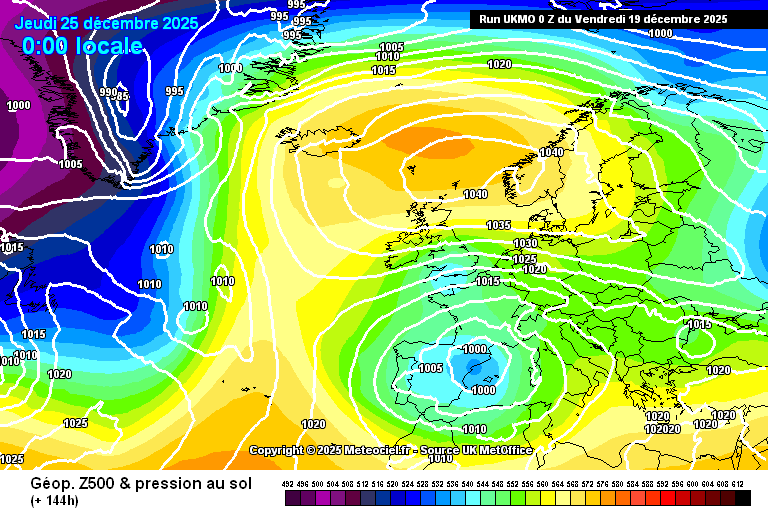
This morning's MetO output is very close. We have a Scandinavian High on Christmas Eve, which moves westwards for Christmas Day. There's a cold pool over the south and a telltale kink in the isobars showing a trough crossing England and Wales.
https://images.meteociel.fr/im/4/17309/ukmo_0_144upz3.png
The 850s are what lets the side down, although -7/-8 might be cold enough for some snow flurries inland:
https://images.meteociel.fr/im/99/26630/ukmo_1_144bjq1.png
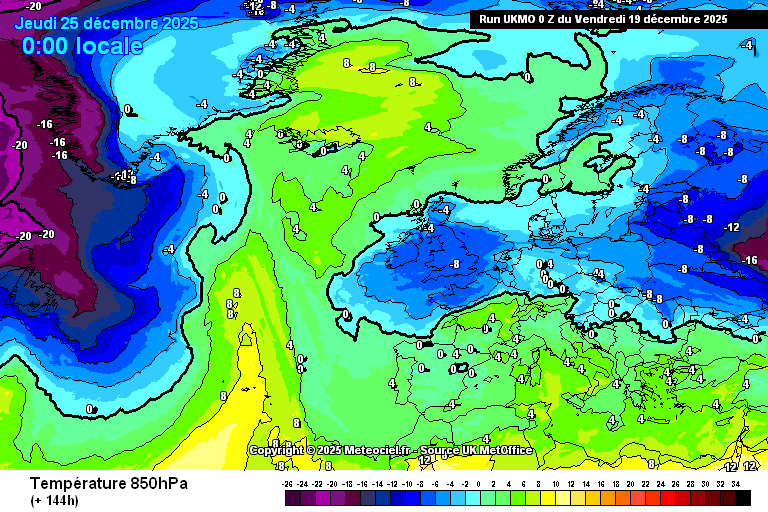
Of course even at 6 days out much will change, and it's unlikely the 850s would be exactly that temperature anyway, let alone the rest of it! Nonetheless, for a rough guide it's very encouraging.
A quick look at the ECM-46 shows it's doubled-down again on the cold, showing cold anomalies in the south for five weeks in a row! By week five they're confined to the SE, but before then we keep our widespread -3 to -1 anomalies for the week after next. There's been a slight downgrade in the extent of the deep cold air over France - maybe 30 miles further east from Calais - but the picture remains a solidly colder than average one.
https://charts.ecmwf.int/products/extended-anomaly-2t?base_time=202512180000&projection=opencharts_europe&valid_time=202601050000
The pressure charts continue to show high anomalies to the north for a couple of weeks, suggesting we may well see the high migrating westwards with time, but not scooting off tout de suite to Canada as has happened in recent decades. There's a weak signal for higher pressure to the NE in week 3, and that'd imply a good chunk of the ensemble members are showing that ping-pong effect I mentioned yesterday.
https://charts.ecmwf.int/products/extended-anomaly-mslp?base_time=202512180000&projection=opencharts_europe&valid_time=202512290000
All in all, it's still very encouraging. If nothing else we'll all notice the change, and Christmas Day is shaping up to feel absolutely perishing down here. The MetO raw, for example, has 5C at noon, overcast, with a biting ENE'ly wind (biting due to the relatively low dewpoints). The current balmy weather will seem a long way away next week!