The Weather Outlook

Remove ads from site

28 December 2024 19:05:47
Interesting to see met text mention easterly flow probability. Could a snap turn into a spell? First in 6 years down here.
Berkshire
Devonian
28 December 2024 19:33:01

2009 was spotted around 10 days in advance by GEFS - first as a couple of stragglers, then gradually more and more members followed suit.

2010 was similar, GEFS started to cotton on around 10 days out, and unlike 2009 once it picked up on it there was far less scatter.

2010 was also spotted a good month in advance by GLOSEA, I remember the MetO long-range text forecast being very bullish on it throughout... more bullish than they've ever been at that range since!

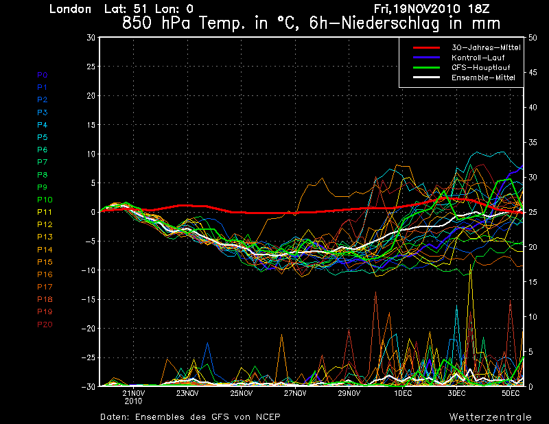
Here's a snapshot of the GEFS just as the autumn/winter 2010 cold spell was kicking off down here. It's interesting to compare it to the current output...

(And FWIW it persisted in trying to return to normality throughout the cold spell, there weren't any days when it was showing cold throughout the run!)

https://ukwct.org.uk/weather/2010/ens.png 

UserPostedImage

Originally Posted by: Retron 

Going further back I think I remember the Jan 1987 cold spell being predicted some time in advance, and I think the 'Brear* storm' too. Notable events do somehow show themselves early.

But it's 2024 and this current spell doesn't look like proper winter to me, but I'm hopeful we might see a decent frost out of it - the first of the winter if it happens.

*wrong spelling?

ABainbridge
28 December 2024 19:41:51

There were hiccups, but that was more because the WZ charts kept messing up! Here's an animation of the end of November's charts, minus a couple where WZ went haywire (one with green lines all over, one with just the op run and nothing else).

It'll be an interesting comparison with the current output.

https://i.postimg.cc/52wFQ8Bq/ani.gif 

Originally Posted by: Retron 

Excellent. Thanks!  Clearly did vary a certain amount, but the trend was pretty obvious.

tallyho_83
28 December 2024 20:10:17
ECM 12Z @ 240z shows -10c uppers just by the east coast on 7th midday:

Wind-chill would make it brutally cold if this came off esp in the south in this still easterly winds and temps around the 0 to +2c mark!? - Will it bring any snow with it though?? - time will tell and it's not often we get upgrades in cold weather re computer models. All eyes on 18z now i guess?

https://www.theweatheroutlook.com/charts/ecm/12_240_mslp850uk.png 

UserPostedImage


Home Location - Vixen Tor Close, Okehampton, Devon (221m ASL)

---------------------------------------

Sean Moon

Magical Moon

www.magical-moon.com

tallyho_83
28 December 2024 20:18:45
Given the zonal winds are so strong at 10hpa, it's unusual to see the models go cold is it not? and it looks like the zonal flow will go record breakingly strong in the news few days yet again? There must be a Decoupling...would you agree!? I don't have access to the NAO but if anyone has access to it how is it looking? I can only see it on gavsweathervids? thanks
Home Location - Vixen Tor Close, Okehampton, Devon (221m ASL)

---------------------------------------

Sean Moon

Magical Moon

www.magical-moon.com

White Meadows
28 December 2024 20:54:04

Given the zonal winds are so strong at 10hpa, it's unusual to see the models go cold is it not? and it looks like the zonal flow will go record breakingly strong in the news few days yet again? There must be a Decoupling...would you agree!? I don't have access to the NAO but if anyone has access to it how is it looking? I can only see it on gavsweathervids? thanks

https://www.cpc.ncep.noaa.gov/products/precip/CWlink/pna/nao.gefs.sprd2.png

https://www.cpc.ncep.noaa.gov/products/precip/CWlink/pna/nao.gefs.sprd2.png 

White Meadows
28 December 2024 20:56:54
What’s more striking is the depth and longevity of the AO index:

https://www.cpc.ncep.noaa.gov/products/precip/CWlink/daily_ao_index/ao.shtml 

White Meadows
28 December 2024 21:10:40
Met office text for early mid Jan is interesting …reading between the lines you could deduce there’s a chance (albeit currently small) a significant cold spell is possible. 

Perfect time of year too.

jhall
28 December 2024 21:37:43

ECM 12Z @ 240z shows -10c uppers just by the east coast on 7th midday:

Wind-chill would make it brutally cold if this came off esp in the south in this still easterly winds and temps around the 0 to +2c mark!? - Will it bring any snow with it though?? - time will tell and it's not often we get upgrades in cold weather re computer models. All eyes on 18z now i guess?

https://www.theweatheroutlook.com/charts/ecm/12_240_mslp850uk.png 

UserPostedImage

Originally Posted by: tallyho_83 

Because in the south the air would have had a fairly short sea track, it wouldn't have been warmed as much from below by the telatively warm sea, so a temperature of -9 at 850mb might well result in a sub-zero maximum at the surface.


Cranleigh, Surrey
tallyho_83
28 December 2024 21:39:52

What’s more striking is the depth and longevity of the AO index:

https://www.cpc.ncep.noaa.gov/products/precip/CWlink/daily_ao_index/ao.shtml 

Originally Posted by: White Meadows 

Thanks for that White Meadows 

I have book marked it.

A negative NAO and AO - but a very strong zonal wind forecast at 10hpa and a colder than average stratosphere at 10hpa? Now that's interesting eh? Definitely a decoupling then. Keen to see what the 18z will bring...


Home Location - Vixen Tor Close, Okehampton, Devon (221m ASL)

---------------------------------------

Sean Moon

Magical Moon

www.magical-moon.com

squish
28 December 2024 22:33:00
If the 18z comes off …lots of snow ( for most )
D.E.W on Dartmoor. 300m asl
Quantum
28 December 2024 22:45:09
Yikey crikey the 18Z has gone full reverse zonality.


25/26 (850hpa temp) 11 days snow/sleet falling

18/11 (-4) 19/11 (-6) 20/11 (-6) 01/01 (-7) 04/01 (-10) 10/01 (-7) 11/01 (-3) 30/01 (-1) 13/02 (-6) 15/02 (-4) 18/02 (-6)

24/25 10d

18/11 (-6) 19/11 (-6) 23/11 (-2) 22/12 (-5) 04/01 (-5) 05/01 (0)14/02 (0) 15/02 (0)12/03 (-6) 13/03 (-6)

23/24 8d

29/11 (-6) 30/11 (-6) 02/12 (-5) 03/12 (-5) 04/12 (-3) 16/01 (-3) 18/01 (-8)08/02 (-5)

22/23 7d

18/12 (-1)06/03 (-6) 08/03 (-8) 09/03 (-6) 10/03 (-8) 11/03 (-5) 14/03 (-6)

21/22 12d

idj20
28 December 2024 22:50:52
Just a shame that there is that spell of stormy winds over a large swathe of Southern England on New Year's Day to get through first, and even after that the snow situation is still looking tenuous for the South Coast gang. 😁 Honestly, it's like pulling teeth.

As always I'm keeping expectations low for the rest of this Winter while at the same time willing Spring proper to start ASAP.


Home location: Folkestone Harbour.
scillydave
28 December 2024 23:00:57
Glad to see the GFS 18z has gone full 'Day After Tomorrow' on us.

What an extraordinary run in terms of snow depth and longevity. Would be generally crippling for parts of the country if that came off.


Currently living at roughly 65m asl North of Cowbridge in the Vale of Glamorgan.

Formerly of, Birdlip, highest village in the Cotswolds and snow heaven in winter; Hawkinge in Kent - roof of the South downs and Isles of Scilly, paradise in the UK.

Matty H
28 December 2024 23:05:31
18z GFS Op is hilarious 
Yate, Nr Bristol

TBFTEIARBSC

Crepuscular Ray
28 December 2024 23:09:56
Surely the GFS 18z can't come off? It would be an incredible 12 days in northern and eastern Scotland!!!
Jerry

Edinburgh, in the frost hollow below Blackford Hill

tallyho_83
28 December 2024 23:33:41
18z GFS op run shows at least 3 if not 4 snowfall events in the south from channel lows pushing up and eastwards and stalling/stagnating. The low on 2nd but depends on tracking of it, BUT 4th & again on 5th shows snow, followed by easterly winds and channel low to form and bring snow to the south on 6 and 7th and another channel low on 9th to 11th bringing heavy snow to the south. I looked at the ENS briefly and the OP is a mild outlier between 4th -8th! wow! As for the OP it shows daytime maxes still at or just a smidge above freezing by 13th January and that's a long way off now but goodness me! - The 18z control run plunges the UK into the freezer!

I would be gutted if not one came off despite all that. On the plus side we are seeing upgrades in the cold each run and the positioning of the low is crucial. Timings are almost nailed on but the positioning isn't it could take a southerly track or more northerly. Very interesting times ahead!

The caveat is that NE America are expecting a cold spell as well and usually we all know what this means for the UK, so i will remain cautious until Monday at least. It could all go Pete tong! We have been here before but I can't remember seeing such cold blocked charts in January for several years and even then they have not always verified, so I am remaining cautious!


Home Location - Vixen Tor Close, Okehampton, Devon (221m ASL)

---------------------------------------

Sean Moon

Magical Moon

www.magical-moon.com

Matty H
28 December 2024 23:49:21

18z GFS op run shows at least 3 if not 4 snowfall events in the south from channel lows pushing up and eastwards and stalling/stagnating. The low on 2nd but depends on tracking of it, BUT 4th & again on 5th shows snow, followed by easterly winds and channel low to form and bring snow to the south on 6 and 7th and another channel low on 9th to 11th bringing heavy snow to the south. I looked at the ENS briefly and the OP is a mild outlier between 4th -8th! wow! As for the OP it shows daytime maxes still at or just a smidge above freezing by 13th January and that's a long way off now but goodness me! - The 18z control run plunges the UK into the freezer!

I would be gutted if not one came off despite all that. On the plus side we are seeing upgrades in the cold each run and the positioning of the low is crucial. Timings are almost nailed on but the positioning isn't it could take a southerly track or more northerly. Very interesting times ahead!

The caveat is that NE America are expecting a cold spell as well and usually we all know what this means for the UK, so i will remain cautious until Monday at least. It could all go Pete tong! We have been here before but I can't remember seeing such cold blocked charts in January for several years and even then they have not always verified, so I am remaining cautious!

Originally Posted by: tallyho_83 

You’d be gutted if not one came off? None have been showing at all like this, prior to this. I haven’t looked at the ens, but I’d imagine this projection has little support from its own model let alone other models. Maybe it has….


Yate, Nr Bristol

TBFTEIARBSC

squish
28 December 2024 23:55:45
Short ensembles tightly clustered and trending colder 
D.E.W on Dartmoor. 300m asl
Arbroath 1320
29 December 2024 00:37:14
The model agreement for a significant cold spell from 1 January over much of the UK is quite remarkable at present. Plenty of time for things to change though.

While the excitement is understandable, all the IMBY posts, e.g., channel lows giving snow, this far out is very optimistic. The precise location of tracking lows is questionable, as little as 12 hours, if not less. 

Hopefully we can continue to read the excellent analysis on here giving an objective view on the model output for the UK as a whole, without the tedious Kent, the Midlands or Surrey, etc, is going to get plastered. 

Apologies for the rant, but I find IMBYISM tedious.


Kenmore, Highland Perthshire, GGTTH
Gandalf The White
29 December 2024 00:45:20

You’d be gutted if not one came off? None have been showing at all like this, prior to this. I haven’t looked at the ens, but I’d imagine this projection has little support from its own model let alone other models. Maybe it has….

Originally Posted by: Matty H 

Amusingly, Matty, the only time the Op was not supported by the ensemble suite was on the two occasions in the run when it went briefly less cold.  The 850hPa mean stays below -5c here from 2/1 until the final day.  Interestingly the median is below the mean for much of the run.

The Op was in line with the mean for cumulative precipitation for the first week but ends up in the top decile by the end.


Location: South Cambridgeshire

130 metres ASL

52.0N 0.1E


tallyho_83
29 December 2024 00:51:01
18z GFS Ensembles:

Op shows to be a milder outlier between 3rd and 9th:

UserPostedImage


Home Location - Vixen Tor Close, Okehampton, Devon (221m ASL)

---------------------------------------

Sean Moon

Magical Moon

www.magical-moon.com

Karl Guille
29 December 2024 00:54:01
A decent 18z set even down here in the far south.  Interesting times.

https://modeles16.meteociel.fr/modeles/gensp/runs/2024122818/graphe3_10000_220_248___.gif 


St. Sampson

Guernsey

The Beast from the East
29 December 2024 01:30:02

Just a shame that there is that spell of stormy winds over a large swathe of Southern England on New Year's Day to get through first, 

Originally Posted by: idj20 

Yes, you cant really look forward to a cold spell with that threat hanging over us.  We have been lucky so far with the storms which havent really caused much damage. Perhaps our luck will run out now. Would be a terrible start to the new year.


Purley, Surrey, 70m ASL

"We have some alternative facts for you"

Kelly-Ann Conway - former special adviser to the President

Remove ads from site