The Weather Outlook

Remove ads from site

Retron
  • Retron
  • Advanced Member Topic Starter
14 December 2024 12:14:00
The 6z GEFS control couldn't be more different to the 0z - it has snow falling across the far SE on Christmas morning.

It goes to show that this is far from nailed-on, but it's still 11 days out - plenty more changes to come, I'd wager.

https://images.meteociel.fr/im/63/20955/gens_0_1_264zsw8.png 

UserPostedImage


Leysdown, north Kent
David M Porter
14 December 2024 13:25:31

The 6z GEFS control couldn't be more different to the 0z - it has snow falling across the far SE on Christmas morning.

It goes to show that this is far from nailed-on, but it's still 11 days out - plenty more changes to come, I'd wager.

https://images.meteociel.fr/im/63/20955/gens_0_1_264zsw8.png 

UserPostedImage

Originally Posted by: Retron 

Indeed, Darren.

Look at how long it took the models just over a week ago to fully resolve the exact track that Storm Darragh was going to take last Friday and Saturday, for instance.


Lenzie, Glasgow

"A body of men holding themselves accountable to nobody ought not to be trusted by anybody." – Thomas Paine

CField
14 December 2024 14:25:05
Lots of models going for this nw to se flow...not a natural set up for modern Decembers...the AIFS to me is the one on the money....almost a summer looking model...lets see if this nw zonal flow evaporates as we head towards Xmas..
Favourite snowstorm

Famous channel low

Dec 31st 1978

Hastings East Sussex

Foot of level snow severe drifting

Next day max temp -4 degrees Celsius

Brian Gaze
14 December 2024 17:26:27
GFS 12Z looks like the type of thing which could bring a white Christmas (at least a technical one) to parts of Scotland. However, for most of us it is mild and to me it looks like it firs in comfortably with a number of recent years. However, there is still time for change and the countdown remains fun.

UserPostedImage


Brian Gaze

Berkhamsted

TWO Buzz - get the latest news and views 

"I'm not socialist, I know that. I don't believe in sharing my money." - Gary Numan

Jiries
14 December 2024 17:59:07

GFS 12Z looks like the type of thing which could bring a white Christmas (at least a technical one) to parts of Scotland. However, for most of us it is mild and to me it looks like it firs in comfortably with a number of recent years. However, there is still time for change and the countdown remains fun.

UserPostedImage

Originally Posted by: Brian Gaze 

Wish it was national wide cold like if Scotland get this similar set up by Xmas :

https://www.youtube.com/watch?v=Cp4RRAEgpeU

 -18C in Scotland and we get sub -10C here will be best Xmas cold spell with snow around.  

ballamar
14 December 2024 19:24:31
ECM is the beacon of light for Xmas day even if not too cold - the charts look a little interesting 
nsrobins
14 December 2024 19:56:40
Just maybe - a hint of hope that Xmas Eve night might just deliver.
Neil

Fareham, Hampshire 28m ASL (near estuary)

Stormchaser, Member TORRO

Gandalf The White
14 December 2024 21:23:57

Just maybe - a hint of hope that Xmas Eve night might just deliver.

Originally Posted by: nsrobins 

😮

That’s almost as bad as Brian putting polar bears on the home page. 🤔😉


Location: South Cambridgeshire

130 metres ASL

52.0N 0.1E


Retron
  • Retron
  • Advanced Member Topic Starter
15 December 2024 06:07:10
Christmas Day is now 10 days away, meaning that confidence will now increase markedly each day.

GFS opens with complex low pressure to the north and a ridge from the Azores High over northern Iberia, sandwiching the UK under westerlies. These are cold enough in the NW  half of Scotland to bring snow, something which continues through the day.

UserPostedImage

https://images.meteociel.fr/im/50/24088/gfs_0_240jch4.png 

The GEFS control has the UK under strong WSW'lies with a broadly similar synoptic setup. The slight change in wind direction means there's no snow to be had, though, with rain over Scotland instead.

We're now seeing fewer clusters in the output, with today's offerings being:

Ridge from south over England and Wales, WSW'lies: 10

Weak ridge over UK, westerlies: 7

Ridge to west, WNW'lies: 6

Weak trough over UK, westerlies: 4

Then there are a few one-offs, including a col over England and Wales with SW'lies elswehere, complex low pressure to the north with cold westerlies, and a trough to the east with relatively cold WSW'lies.

Compared to previous days winds from a westerly quarter are present in all the members, representing anything from widespread snow to wet, windy and mild conditions across the UK. Unusually the spread is quite narrow, mostly WNW'ly to WSW'lies, with SW'lies or SSW'lies absent. The GFS operational run sits towards the colder end of the spread.

Today's standout run is member 4, which has an active cold front sweeping SE'wards across the UK, bringing snow to most during Christmas Day.

UserPostedImage

https://images.meteociel.fr/im/79/17611/gens_4_1_240sot4.png 


Leysdown, north Kent
Brian Gaze
15 December 2024 08:39:10
Here's the GEFS snow depth animation for Christmas Day using the 00Z data.

UserPostedImage


Brian Gaze

Berkhamsted

TWO Buzz - get the latest news and views 

"I'm not socialist, I know that. I don't believe in sharing my money." - Gary Numan

Brian Gaze
15 December 2024 08:43:37
GEFS 00Z 2m temperature clusters for London day by day.  

UserPostedImage


Brian Gaze

Berkhamsted

TWO Buzz - get the latest news and views 

"I'm not socialist, I know that. I don't believe in sharing my money." - Gary Numan

CField
15 December 2024 08:49:35

Here's the GEFS snow depth animation for Christmas Day using the 00Z data.

UserPostedImage

Originally Posted by: Brian Gaze 

Last time I remember snowflakes falling from the sky was on Xmas day in 1970...pretty crazy wait now....I'm sure a short lived cold settled snap early mid January will happen before that gets pummeled away by stormy weather and named storms and a cold snap end of February early March  from a Mojo phase will occur that'll be it.Think heights to south will keep autumn going in the south at least for the next 9 weeks or so...roll on summer!


Favourite snowstorm

Famous channel low

Dec 31st 1978

Hastings East Sussex

Foot of level snow severe drifting

Next day max temp -4 degrees Celsius

doctormog
15 December 2024 08:58:41
This graphic from Meteociel is quite a nice snapshot of the latest GEFS ensemble suite snow falling probability* for Christmas Day.

https://modeles16.meteociel.fr/modeles/gensp/run/gensprobuk-26-264.png?0 

(*Yes I know it’s not a percentage probability rather the percentage of members showing falling snow, but you get the point)


ballamar
15 December 2024 09:04:26
Hopefully the models had their Christmas party this weekend and will bring back some hope next week. Think how the low interacts with the ridge at the end of the week is key, if that can flatten the high as opposed to inflating the ridge it could change.
Gandalf The White
15 December 2024 10:02:53

Hopefully the models had their Christmas party this weekend and will bring back some hope next week. Think how the low interacts with the ridge at the end of the week is key, if that can flatten the high as opposed to inflating the ridge it could change.

Originally Posted by: ballamar 

I have to say that the trend appears to be for the high pressure to be more influential, so we’re left with the positioning. Most likely at the moment is dryish and settled and therefore maybe a chance of it being coldish at the surface.


Location: South Cambridgeshire

130 metres ASL

52.0N 0.1E


Brian Gaze
15 December 2024 11:30:06

I have to say that the trend appears to be for the high pressure to be more influential, so we’re left with the positioning. Most likely at the moment is dryish and settled and therefore maybe a chance of it being coldish at the surface.

Originally Posted by: Gandalf The White 

An inversion looks like a possibility in the south, but the GFS 06Z doesn't get there.

UserPostedImage


Brian Gaze

Berkhamsted

TWO Buzz - get the latest news and views 

"I'm not socialist, I know that. I don't believe in sharing my money." - Gary Numan

doctormog
15 December 2024 11:53:39
The GFS 06z operational run is the warmest of the entire suite here on Christmas Day afternoon (the other extreme is sub -10°C at t850hPa)
Brian Gaze
15 December 2024 17:53:01
It looks like 9 of the GEFS 12Z runs show chilly to cold conditions in the south on Christmas Day. I've not looked through the runs but presumably some are managing to generate an inversion. I've animated all in the Tweet.


Brian Gaze

Berkhamsted

TWO Buzz - get the latest news and views 

"I'm not socialist, I know that. I don't believe in sharing my money." - Gary Numan

Saint Snow
15 December 2024 19:22:53

Last time I remember snowflakes falling from the sky was on Xmas day in 1970...pretty crazy wait now....I'm sure a short lived cold settled snap early mid January will happen before that gets pummeled away by stormy weather and named storms and a cold snap end of February early March  from a Mojo phase will occur that'll be it.Think heights to south will keep autumn going in the south at least for the next 9 weeks or so...roll on summer!

Originally Posted by: CField 

Last time snow fell and stuck on Xmas Day here was 2004. That was from showers on a NW'ly, flipping between snow pellets and flake for about an hour and half. Left around 4-5cm. Skies then cleared and, by 6pm, it was sub-zero and everything froze. Driving was perilous. 

I'd absolutely love a repeat.

(even if it was largely gone by the 27th)


Martin

Home: St Helens (26m asl) Work: Manchester (75m asl)

A TWO addict since 14/12/01

"How can wealth persuade poverty to use its political freedom to keep wealth in power? Here lies the whole art of Conservative politics."

Aneurin Bevan

David M Porter
15 December 2024 19:52:51

Last time snow fell and stuck on Xmas Day here was 2004. That was from showers on a NW'ly, flipping between snow pellets and flake for about an hour and half. Left around 4-5cm. Skies then cleared and, by 6pm, it was sub-zero and everything froze. Driving was perilous. 

I'd absolutely love a repeat.

(even if it was largely gone by the 27th)

Originally Posted by: Saint Snow 

Your location must have been one of those unlucky ones that missed out on a white Xmas in 2009 and 2010, Saint. We had not far off a foot of snow on the ground here on both occasions; in 2010 it has been lying since the start of that freeze in late November.


Lenzie, Glasgow

"A body of men holding themselves accountable to nobody ought not to be trusted by anybody." – Thomas Paine

Saint Snow
15 December 2024 20:22:56

Your location must have been one of those unlucky ones that missed out on a white Xmas in 2009 and 2010, Saint. We had not far off a foot of snow on the ground here on both occasions; in 2010 it has been lying since the start of that freeze in late November.

Originally Posted by: David M Porter 

Oh, we had deep snow on the ground both those Christmases - but I don't think snow fell on the actual day itself.

We also had a thin (1cm) covering in I think 1996 that fell overnight. I was expecting just a frost, so was delightfully surprised when I woke and saw that.

Also had an almost freak snowfall Boxing Day 2014. Very marginal - but an area of SW Lancashire got very lucky. Put about 7-8cm (but turned to rain later in the evening and was all but gone by the morning)


Martin

Home: St Helens (26m asl) Work: Manchester (75m asl)

A TWO addict since 14/12/01

"How can wealth persuade poverty to use its political freedom to keep wealth in power? Here lies the whole art of Conservative politics."

Aneurin Bevan

Essan
15 December 2024 22:16:30

Last time snow fell and stuck on Xmas Day here was 2004. That was from showers on a NW'ly, flipping between snow pellets and flake for about an hour and half. Left around 4-5cm. Skies then cleared and, by 6pm, it was sub-zero and everything froze. Driving was perilous. 

I'd absolutely love a repeat.

(even if it was largely gone by the 27th)

Originally Posted by: Saint Snow 

I think that was the last time I saw snow fall on Christmas Day - just enough to give a light dusting. Before that I think there was some sleet in 1999.

And 2010 was the only time (since 1981) that I have seen a covering of snow on the ground on Christmas Day.

Snow at Christmas has never been normal in my lifetime, so why do we fuss about it so much?    It's a bit like expecting a thunderstorm on  25th June every year ......


Andy

Evesham, Worcs, Albion - 35m asl

Weather & Earth Science News 

Look in the doubt we've wallowed, look at the leaders we've followed, look at the lies we've swallowed, and I don't want to hear no more

Retron
  • Retron
  • Advanced Member Topic Starter
16 December 2024 06:18:45

ISnow at Christmas has never been normal in my lifetime, so why do we fuss about it so much?    It's a bit like expecting a thunderstorm on  25th June every year ......

Originally Posted by: Essan 

In my case it's because I want to see, just once before I die, snow falling and settling on Christmas Day. That hasn't happened in my lifetime (and I'm 45), the last such time being 1970. In my life there's been snow on the ground (twice, once when I was 2) and a few flakes falling, with no snow on the ground or settling - in a blink-and-you'll miss it, have to look really hard to see them, 30 seconds max thing - twice. I strongly suspect I'll snuff it without seeing proper snow falling (as in seeing it without staring hard at a dark area of the garden) and settling, which is a shame.

Anyway, onto today's analysis!

We're now 9 days away from Christmas Day, and the overall theme is similar to yesterday.

The operational GFS has a large high over northern France, ridging southwards, with the UK under mild WSW'lies. There's rain for NW Scotland, with low pressure to the NW.

UserPostedImage

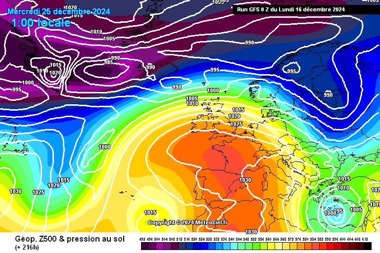
https://images.meteociel.fr/im/62/2937/gfs_0_216stx2.png 

The GEFS control is similar, also with a high centred over northern France and mild WSW'lies across the UK. There's a bit more rain over northern and western Scotland, but it's still too mild for any wintriness.

Delving deeper, the GEFS members show the following clusters:

High to south, mild WSW'lies: 11

Trough crossing the UK, WSW'lies: 8

High to ESE, southerlies and SW'lies: 3

Ridge to west, westerlies: 2

There are more one-offs compared to yesterday, including SW'lies with a trough to the west, an active cold front moving south with cold NW'lies following behind, and a ridge over England and Wales with SW'lies elsewhere.

The general picture remains a westerly one, with WSW'lies most likely, and a good chance of strong WSW'lies at that. Inside that group is a bit of variation; although most members bring mild air across the UK, a few are cold enough in the far north/NW of Scotland to bring snow.

Today's standout is member 6, which has a trough moving ESE'wards over the UK with sleet and snow in its wake - right down to the south and southeast coasts.

UserPostedImage

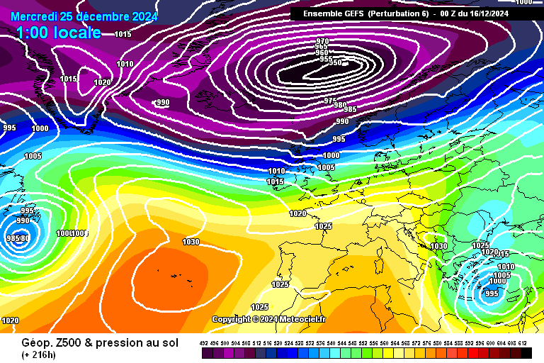
https://images.meteociel.fr/im/93/27068/gens_6_1_216yxm2.png 


Leysdown, north Kent
Brian Gaze
16 December 2024 06:30:44
Last night's 18Z suggested the possibility of a new Christmas day temperature record, with a foehn-effect producing 15C in eastern Scotland. The target is 15.6C in 1920.

Temperatures on this morning's 00Z aren't as high. Also, that area of high pressure to the south is looking so robust I do wonder whether GFS could be overcooking temperatures, at least in southern Britain, as it did in early November.

UserPostedImage


Brian Gaze

Berkhamsted

TWO Buzz - get the latest news and views 

"I'm not socialist, I know that. I don't believe in sharing my money." - Gary Numan

Remove ads from site