The Weather Outlook

Remove ads from site

Retron
  • Retron
  • Advanced Member Topic Starter
12 December 2024 06:30:52
This morning's GFS shows the Azores High displaced to the NE, ridging into Biscay. Westerlies and WSW'lies cover the UK, with gusty WSW'lies and mild very mild temperatures - in double figures widely.

https://images.meteociel.fr/im/17/2203/gfs_0_312ebj4.png 

UserPostedImage

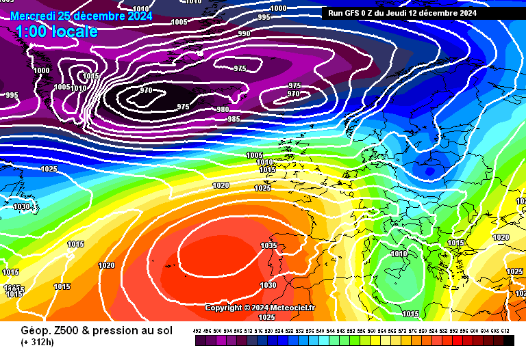
The control at first glance looks similar, with high pressure to the SW and south, but there's somewhat colder air over the SE half of the UK. Winds are lighter westerlies compared with the operational run.

The ensembles continue to be mixed. This morning's options include:

Cyclonic SW'lies or WSW'lies: 7

Ridge to west with westerlies: 6

Ridge from east over UK: 3

Ridge from south over UK: 2

Complex lows to the NW, north and NE, cold westerlies and WNW'lies: 2

Complex low over Scandinavia, cold NW'lies: 2

The rest include a Scandinavian High, a low to the south with weak easterlies, a trough crossing the UK and a North Sea low, amongst others.

A westerly flow remains the most likely option, with a few of the members continuing to show colder weather from a northerly quarter.

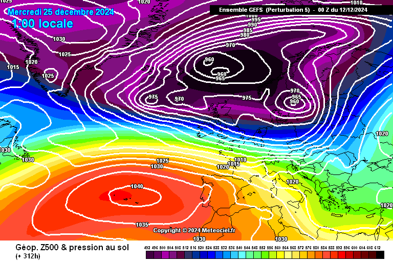
Today's standout is number 5, which has snow falling and settling for the vast majority of Scotland, Northern Ireland and northern England, with snow falling further a bit further south too.

https://images.meteociel.fr/im/97/10407/gens_5_1_312cio9.png 

UserPostedImage

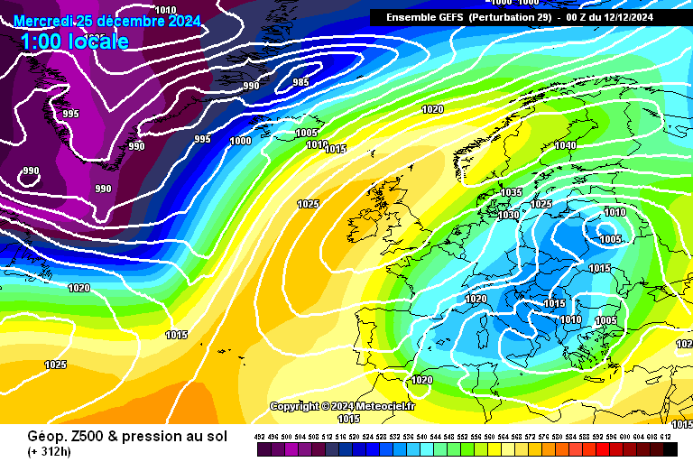
Number 29 is also worth a mention - it has a Scandinavian High with snow falling and accumulating across the far SE on Christmas evening into Boxing Day.

https://images.meteociel.fr/im/37/20981/gens_29_1_312ehe7.png 

UserPostedImage


Leysdown, north Kent
ballamar
12 December 2024 08:16:24
Think it’s now at the realisation stage that unlikely to be a widespread white Christmas! Now it’s the possibility of wintry showers which have been so rare in the south but better chance in the north! Still time for a surprise but think that wait will go on
ballamar
12 December 2024 10:58:54
The op run certainly piques interest for Xmas day, one run and all that but….
Russwirral
12 December 2024 11:25:14
The only hint of consistency at the moment, is that there has been suggestions of a northerly plunge in various strengths in the models over the past few days for the Xmas week.

 The current run is on the stronger side, chance are the next run will be on the weaker side.    All to play for .


Brian Gaze
12 December 2024 11:30:42
Some VERY low temperatures on the GFS 06Z 26/12 - 27/12.

UserPostedImage


Brian Gaze

Berkhamsted

TWO Buzz - get the latest news and views 

"I'm not socialist, I know that. I don't believe in sharing my money." - Gary Numan

Brian Gaze
12 December 2024 11:33:02
I've just removed a post from someone who has previously been warned. (Replies are removed automatically) If it happen again that poster will be suspended until 1st March.
Brian Gaze

Berkhamsted

TWO Buzz - get the latest news and views 

"I'm not socialist, I know that. I don't believe in sharing my money." - Gary Numan

Gandalf The White
12 December 2024 11:55:42
I put this in the MOD thread but perhaps it belongs here as well.

Just for fun, the snow cover chart for the Saturday after Xmas, since it’s the consequence of a reasonably sustained cold snap.

https://www.meteociel.fr/modeles/gfse_cartes.php?ech=384&code=0&mode=16 


Location: South Cambridgeshire

130 metres ASL

52.0N 0.1E


The Beast from the East
12 December 2024 11:59:50

Think it’s now at the realisation stage that unlikely to be a widespread white Christmas! Now it’s the possibility of wintry showers which have been so rare in the south but better chance in the north! Still time for a surprise but think that wait will go on

Originally Posted by: ballamar 

Yes, the zonal train is set in now, and really there is nothing tangible that can disrupt the jet and allow a block to develop. 

GFS will continue to thrown out the odd straw to clutch, but realistically its looking like another green and miserable Christmas for London and the SE. 


Purley, Surrey, 70m ASL

"We have some alternative facts for you"

Kelly-Ann Conway - former special adviser to the President

Retron
  • Retron
  • Advanced Member Topic Starter
12 December 2024 12:14:27

Yes, the zonal train is set in now, and really there is nothing tangible that can disrupt the jet and allow a block to develop. 

GFS will continue to thrown out the odd straw to clutch, but realistically its looking like another green and miserable Christmas for London and the SE. 

Originally Posted by: The Beast from the East 

Still far too far out to be confident on Christmas Day, I would say - you wouldn't trust any charts at day 10, and we're still 13 days away from the big day!

It's good to see such a wide variety of synoptic situations presenting themselves, even if, as you'd expect at this range, westerlies are in the majority.


Leysdown, north Kent
CField
12 December 2024 12:22:22
That slider on Xmas day will need monitoring on Gfs 06z
Favourite snowstorm

Famous channel low

Dec 31st 1978

Hastings East Sussex

Foot of level snow severe drifting

Next day max temp -4 degrees Celsius

Saint Snow
12 December 2024 12:37:03

I put this in the MOD thread but perhaps it belongs here as well.

Just for fun, the snow cover chart for the Saturday after Xmas, since it’s the consequence of a reasonably sustained cold snap.

https://www.meteociel.fr/modeles/gfse_cartes.php?ech=384&code=0&mode=16 

Originally Posted by: Gandalf The White 

JFF (and it'll no doubt disappear on the 12z), but I'd not turn my nose up at this!

UserPostedImage

https://www.theweatheroutlook.com/charts/gfs/06_264_preciptype.png 


Martin

Home: St Helens (26m asl) Work: Manchester (75m asl)

A TWO addict since 14/12/01

"How can wealth persuade poverty to use its political freedom to keep wealth in power? Here lies the whole art of Conservative politics."

Aneurin Bevan

Russwirral
12 December 2024 12:58:19

JFF (and it'll no doubt disappear on the 12z), but I'd not turn my nose up at this!

UserPostedImage

https://www.theweatheroutlook.com/charts/gfs/06_264_preciptype.png 

Originally Posted by: Saint Snow 

Thats a classic NW erly for me haha, i even have a whatsapp group with some mates called "Cusp" becuase we always are... NWales coast nxt to sea, is fine  but Wirral: nope.


CField
12 December 2024 14:00:16

Thats a classic NW erly for me haha, i even have a whatsapp group with some mates called "Cusp" becuase we always are... NWales coast nxt to sea, is fine  but Wirral: nope.

Originally Posted by: Russwirral 

Remember the good old fashion 3-4 day northerlies,NW first then show showers transferring to Eastern side...dont happen like that anymore


Favourite snowstorm

Famous channel low

Dec 31st 1978

Hastings East Sussex

Foot of level snow severe drifting

Next day max temp -4 degrees Celsius

DEW
  • DEW
  • Advanced Member
12 December 2024 15:32:15

I put this in the MOD thread but perhaps it belongs here as well.

Just for fun, the snow cover chart for the Saturday after Xmas, since it’s the consequence of a reasonably sustained cold snap.

https://www.meteociel.fr/modeles/gfse_cartes.php?ech=384&code=0&mode=16 

Originally Posted by: Gandalf The White 

Alas, the M4 snow barrier seems to be in operation.


War is God's way of teaching Americans geography - Ambrose Bierce

Chichester 12m asl

Retron
  • Retron
  • Advanced Member Topic Starter
12 December 2024 15:36:36

Alas, the M4 snow barrier seems to be in operation.

Originally Posted by: DEW 

Have a look at the 12z GFS - it shows a potent northerly plunge with plenty of snow around, even reaching down here by the 27th.


Leysdown, north Kent
Saint Snow
12 December 2024 15:44:02

Have a look at the 12z GFS - it shows a potent northerly plunge with plenty of snow around, even reaching down here by the 27th.

Originally Posted by: Retron 

Where you seeing that so soon?


Martin

Home: St Helens (26m asl) Work: Manchester (75m asl)

A TWO addict since 14/12/01

"How can wealth persuade poverty to use its political freedom to keep wealth in power? Here lies the whole art of Conservative politics."

Aneurin Bevan

Russwirral
12 December 2024 15:52:56

Remember the good old fashion 3-4 day northerlies,NW first then show showers transferring to Eastern side...dont happen like that anymore

Originally Posted by: CField 

yeh rather than digging in, they seem to bounce off an Atlantic High


Saint Snow
12 December 2024 15:53:41

Where you seeing that so soon?

Originally Posted by: Saint Snow 

I'm assuming Wetter? (I rarely use it!)


Martin

Home: St Helens (26m asl) Work: Manchester (75m asl)

A TWO addict since 14/12/01

"How can wealth persuade poverty to use its political freedom to keep wealth in power? Here lies the whole art of Conservative politics."

Aneurin Bevan

warrenb
12 December 2024 15:57:54
I suspect a typo and should have said 6z, and not 12z
Retron
  • Retron
  • Advanced Member Topic Starter
12 December 2024 16:01:16

I suspect a typo and should have said 6z, and not 12z

Originally Posted by: warrenb 

You're spot on there, of course! I wish I had a secret way to know what was coming up in the next model run. 😂


Leysdown, north Kent
Brian Gaze
12 December 2024 16:36:07

I'm assuming Wetter? (I rarely use it!)

Originally Posted by: Saint Snow 

GFS charts appear more or less in real time on TWO, Wetter and Meteo among others. They start appearing at about 15:35 GMT, although delays occur at times.


Brian Gaze

Berkhamsted

TWO Buzz - get the latest news and views 

"I'm not socialist, I know that. I don't believe in sharing my money." - Gary Numan

Russwirral
12 December 2024 16:45:27
It appears the 12z is treading a consistent theme as 6z

could this be the first back to back run of cold theme for Xmas we are seeing?


Saint Snow
12 December 2024 16:48:14
The same general pattern from the 6z is still showing on the 12z (AH aligned NW/SE and a big low to the north of the UK feeding an increasingly cold NW'ly flow with snow showers for the northern/western half of the UK.

There's quite a contrast to yesterday's 12z, where the AH was centred between the Azores and Biscay and large enough to cover the south of the UK.


Martin

Home: St Helens (26m asl) Work: Manchester (75m asl)

A TWO addict since 14/12/01

"How can wealth persuade poverty to use its political freedom to keep wealth in power? Here lies the whole art of Conservative politics."

Aneurin Bevan

Retron
  • Retron
  • Advanced Member Topic Starter
12 December 2024 16:51:38
Worth mentioning the GEM, which has also been toying with the idea of a colder plunge near Christmas over the past couple of days. Have a look at the 12z from 192 onwards today, for example; it also shows a "diving low" scenario a la the 6z GFS...

I used MC, but it's updating on TWO below:

https://www.theweatheroutlook.com/twodata/gem.aspx 

EDIT: And the 0z ECM AI (but not the op) had a low zipping across the UK in cold air on Christmas Day. Definitely raises an eyebrow, I'd say!


Leysdown, north Kent
David M Porter
12 December 2024 17:30:25
Some of the charts for the start of the Christmas period that have come out today remind me somewhat of the set-up we had for a few days back in mid-January 2018, which was the best relatively recent instance of "cold zonality" in northern areas.

Were such a set-up to verify later this month as suggested by some models, I am far from sure that any wintry precipitation would be entirely confined to high ground.


Lenzie, Glasgow

"A body of men holding themselves accountable to nobody ought not to be trusted by anybody." – Thomas Paine

Remove ads from site