More wildly varying outcomes in today's modelling. Some are disturbingly cold!
Having a gander at the MJO projections, I think I can see a reason. You can hardly have more scatter than this!
So, the models are picking outcomes out of a hat, which have big implications for how a strong area of high pressure moves about in our vicinity next week.
Outcomes with a more active MJO through phase 1 (further from the middle circle, in the triangle labelled '1') support north(west)ward movement of the high, setting up cold feeds from the northeast or north.
Ones with a less active MJO support more of a UK-focused high, with some very pleasant weather on offer, albeit with cool nights, perhaps a bit cold in the southeast with a risk of frost.
Those which shift the MJO on through phase 2 instead favour a shift of that high pressure toward Central Europe, placing us in a fairly warm regime. Not long ago, some of the GFS runs were going down that route. Oh how I dream of those charts  .
.
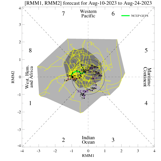
Incidentally, this is another of those simply unpredictable situations! 
If you have any problems or queries relating to TWO you can Email
[email protected] 🙂
https://twitter.com/peacockreports 2021's Homeland Extremes:
T-Max: 30.4°C 21st Jul | T-Min: -6.8°C New Years Day! | Wettest Day: 34.1mm 2nd Oct | Ice Days: 2 (27th Jan & 8th Feb)
Keep Calm and Forecast On