ballamar
23 October 2018 09:59:04
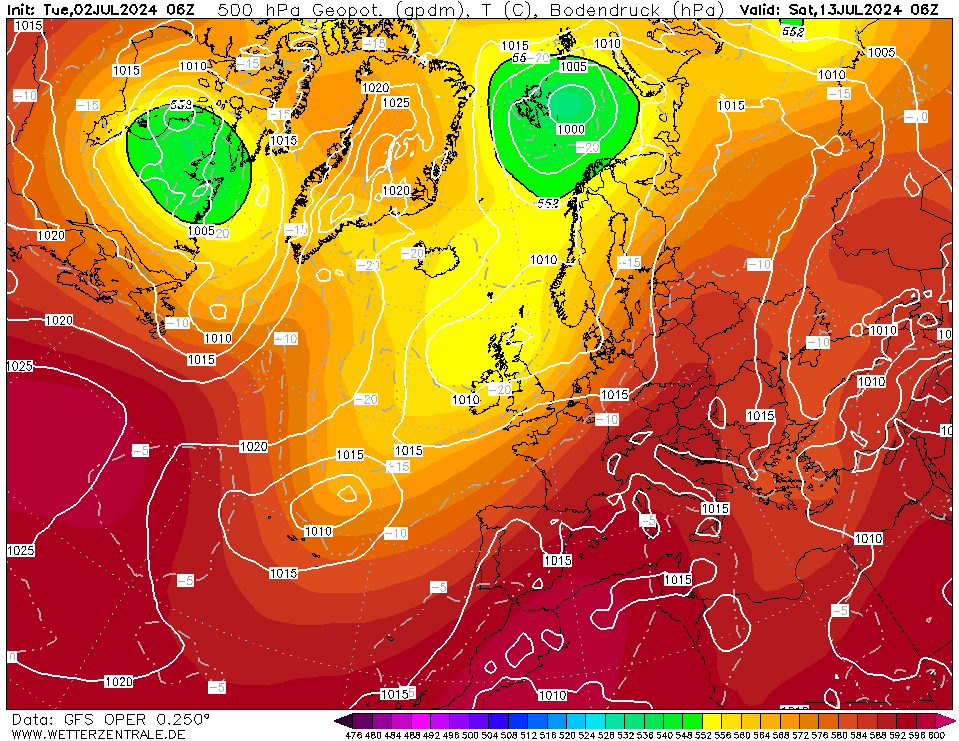
http://www.wetterzentrale.de/maps/GFSOPEU06_84_1.png 

That embedded low in the northerly flow could pep up the precipitation in the flow with some heavier rain and lively showers
doctormog
23 October 2018 10:04:31

Originally Posted by: ballamar 

http://www.wetterzentrale.de/maps/GFSOPEU06_84_1.png  

That embedded low in the northerly flow could pep up the precipitation in the flow with some heavier rain and lively showers


Indeed. There could be some lively convective action associated with that flow. Camera at the ready. 


It strikes me as early in the "the season" for heights to be extending N/NE as they are hinted at doing once again on the 06z GFS op run  


Windy Willow
23 October 2018 10:09:16

The weather is sure looking interesting this weekend, so long as any snow that may fall, down this way, has gone by the 1st of Nov as we're flying from Stanstead then!


119.4 m /391.7 feet asl
Sunny Dartford, NW Kent

Don't feed the Trolls!! When starved of attention they return to their dark caves or the dark recesses of bridges and will turn back to stone, silent again!
tallyho_83
23 October 2018 10:56:43

Just looks more and more blocked' - no sign of any zonality - just look at the HP's systems that seem to keep developing across the north. 


Even out to +240 from Eastern Canada, Greenland, Iceland, Scandinavia  to western Russia etc...!?


This could all change is it's well into FI but given that we have never really entered a wetter few weeks of weather this wouldn't surprise me really if this came off....? All we have had are wetter spells but nothing out of ordinary for Autumn. 


Home Location - Kellands Lane, Okehampton, Devon (200m ASL)
---------------------------------------
Sean Moon
Magical Moon
www.magical-moon.com


tallyho_83
23 October 2018 10:59:53

JUST FOR FUN:


LET'S HOPE THIS PATTERN OCCURS IN December AND MID-WINTER,


Home Location - Kellands Lane, Okehampton, Devon (200m ASL)
---------------------------------------
Sean Moon
Magical Moon
www.magical-moon.com


Saint Snow
23 October 2018 11:02:40

Originally Posted by: tallyho_83 


JUST FOR FUN:


LET'S HOPE THIS PATTERN OCCURS IN December AND MID-WINTER,


Hear! Hear!


Don't even mind a front-loaded winter as long as we get a repeat somewhere between Dec 2009 and Dec 2010.


Martin
Home: St Helens (26m asl) Work: Manchester (75m asl)
A TWO addict since 14/12/01
"How can wealth persuade poverty to use its political freedom to keep wealth in power? Here lies the whole art of Conservative politics."
Aneurin Bevan
JOHN NI
23 October 2018 11:04:51

Originally Posted by: tallyho_83 


JUST FOR FUN:


LET'S HOPE THIS PATTERN OCCURS IN December AND MID-WINTER,


Certainly some interesting possibilities being thrown up as we head into November. Also noticing some very cold air accumulating / forecast across the northern half of Scandinavia - a relatively rare phenomenon so early in the 'winter' in recent decades. If cold air gets entrenched there early on - it might be hard to shift. 


John.
The orange County of Armagh.
Gavin D
23 October 2018 11:38:20

The 7-day trend from the 06z has a small area of orange over ROI elsewhere it remains below average


ANOM2m_trend_europe.thumb.png.e41d75c72088f0d381d489028c30d0c6.png

Maunder Minimum
23 October 2018 11:44:16

Originally Posted by: Gavin D 


The 7-day trend from the 06z has a small area of orange over ROI elsewhere it remains below average


ANOM2m_trend_europe.thumb.png.e41d75c72088f0d381d489028c30d0c6.png


That implies a Scandi HP with attempted incursions from the west. ( I was going to say from the SW, but Spain and Portugal as shown as well below average).


New world order coming.
doctormog
23 October 2018 11:56:18
Remember those charts only show the trend not the actual anomalies. In other words it says the trend for most is for it to get colder over the time period shown (i.e. the difference between day 7 and day 1 not the departure from the climate mean).

In much of SE Europe it will warmer in a week's time compared with tomorrow and here, France, Spain etc. it will be colder.
eddied
23 October 2018 15:49:14
Looks like summer is over then 😉
Location: Reigate, Surrey 105m ASL

Winter 22/23
Days snow falling: 4
Days snow on ground:8
Max snow depths: 6cm (December 19th ish)

Summer 2022 max 39C on July 19th
Summer 2021 max: 32C on July 18th
Summer 2020 max: 36C on July 31st
Crepuscular Ray
23 October 2018 16:13:44

Originally Posted by: eddied 

Looks like summer is over then ;)


Summers been over since late July in the N and NW 😂


Jerry
Edinburgh, in the frost hollow below Blackford Hill
tallyho_83
23 October 2018 17:11:13

Surprised to see a Scandinavian HP develop end of October:


Quite cold airmass to the east esp of Scandinavia - looks like there will be a rapid advance in snow cover for Scandinavia over the next week or so. 


Home Location - Kellands Lane, Okehampton, Devon (200m ASL)
---------------------------------------
Sean Moon
Magical Moon
www.magical-moon.com


tallyho_83
23 October 2018 17:14:48

Looking promising for a negative AO to continue from next weekend but will it hold on:


(We have had months of positivity...maybe months of Negativity?


Home Location - Kellands Lane, Okehampton, Devon (200m ASL)
---------------------------------------
Sean Moon
Magical Moon
www.magical-moon.com


Whiteout
23 October 2018 17:30:48

Originally Posted by: eddied 

Looks like summer is over then ;)


Yep, think that is our lot, can’t complain though, straight into winter then bypassing autumn 


Home/Work - Dartmoor
240m/785 ft asl

Winter 22/23:

Snow falling days - 3
Snow lying days - 3
sizzle
23 October 2018 17:32:35

Originally Posted by: eddied 

Looks like summer is over then ;)

yep we had a long hardcore summer. time for a long hardcore winter

Ally Pally Snowman
23 October 2018 17:35:25

Certainly some stunning winter charts at the moment just 4 weeks to early. 


Bishop's Stortford 85m ASL.
sizzle
23 October 2018 17:38:21

Originally Posted by: Ally Pally Snowman 


Certainly some stunning winter charts at the moment just 4 weeks to early. 


the best charts always come early or late and never on time. unless MR BRIAN calls something special.

tallyho_83
23 October 2018 17:54:52

Originally Posted by: Whiteout 


Yep, think that is our lot, can’t complain though, straight into winter then bypassing autumn 


Remember we never really had a spring! since the beast bit back end of Feb into March and then into 3rd week of March once again - it was only a matter of weeks we saw temps of 18 to 20c and by 21st April we saw temperatures as high as 25c in the south!! Looks like we are going straight from summer to winter ...not the normal weeks of Autumnal wind and rain etc. It was A sunny and pleasant 18c at one point today but maxes of +8c on Saturday. surprised


Home Location - Kellands Lane, Okehampton, Devon (200m ASL)
---------------------------------------
Sean Moon
Magical Moon
www.magical-moon.com


TimS
  • TimS
  • Advanced Member
23 October 2018 20:58:16
29C in April in fact. After the coldest March day in decades.

Apocalyptic thunderstorms, a long summer heatwave and drought, completely cloudless early May bank holiday weekend, and 26C in mid October. Quite a year.
Brockley, South East London 30m asl
Users browsing this topic

Ads