Gavin P
21 August 2021 09:02:22

Originally Posted by: Global Warming 


Latest CET tracker shows the August CET finishing at 16.2C.


A warmer final 10 days of the month but only enough to bring the CET up to the 1971-2000 mean.


IMAGE. Members enable at bottom of page


Chart 1


IMAGE. Members enable at bottom of page


Chart 2


Thanks my friend! 


Has to be one of the most boring August's for a very long time!


Rural West Northants 120m asl
Short, medium and long range weather forecast videos @ https://www.youtube.com/user/GavsWeatherVids
ARTzeman
21 August 2021 10:24:38

Met Office Hadley       16.4c      Anomaly     0.4c provisional to 20th


Metcheck                    15.99c    Anomaly      -0.24c


Netweather                 16.51c    Anomaly      0.32c


Peasedown St John     15.7c     Anomaly      -0.54c.        


Some people walk in the rain.
Others just get wet.
I Just Blow my horn or trumpet
Bertwhistle
21 August 2021 16:47:50

Originally Posted by: Global Warming 


Latest CET tracker shows the August CET finishing at 16.2C.


A warmer final 10 days of the month but only enough to bring the CET up to the 1971-2000 mean.


IMAGE. Members enable at bottom of page


Chart 1


IMAGE. Members enable at bottom of page


Chart 2


So not a big downjustment and that means a mean summer temp comfortably above the 16C to continue the run of 16C+ summers; when June is the colloest month, with fewer days than J or A, it makes a teeny difference to the effect it will have on the summer.


30x 15.5 + 31 x 17.7 + 31 x 16.2 (prov) / 92 = approx 16.48, ahead of 1989, GW's (sorry, Gilbert White not Global Warming) 1783, 1984, 2013 and last year. Good-ho!


Bertie, Itchen Valley.
'We'll never see 40 celsius in this country'.
ARTzeman
22 August 2021 10:19:46

Met Office Hadley      16.4c     Anomaly      0.5c provisional to 21st


Metcheck                   16.0c     Anomaly      -0.23c


Netweather                16.54c   Anomaly       0.35c


Peasedown St John    15.76c   Anomaly     -0.54c.  


Some people walk in the rain.
Others just get wet.
I Just Blow my horn or trumpet
Stormchaser
22 August 2021 19:05:49

I can see the two western CET sites exceeding forecast model predictions this coming week, as we often see that in an easterly flow with at least partly sunny skies. Today, for example, maximum temperatures were 2-3°C above the model figures for many western parts of England.


On the other hand, it's a setup in which minimums can drop below the modelled numbers, as they tend to keep the breeze going too much at night.


So, I'm not sure if the finish will manage to be above GW's 16.2°C projection. The injection of cooler air from the east Fri-Sat really doesn't help - I must admit that's got on my nerves a bit as we usually see such clean easterlies fall short but as we're not in winter...!


What with that and this weekend's sneaky low shenanigans, the long flagged warm final third to August has only just survived. Were it not for that low, we'd almost certainly be looking at some unusually high temperatures for late August in the coming days. The setup was there for a potent incursion of hot air from the south.


A week ago, I was concerned that my CET estimate was going to be over half a degree too low. Now, it's the other way around! 


If you have any problems or queries relating to TWO you can Email [email protected] 🙂
https://twitter.com/peacockreports 
2021's Homeland Extremes:
T-Max: 30.4°C 21st Jul | T-Min: -6.8°C New Years Day! | Wettest Day: 34.1mm 2nd Oct | Ice Days: 2 (27th Jan & 8th Feb)
Keep Calm and Forecast On
Spring Sun Winter Dread
23 August 2021 08:37:19
This August is reminding me very much of 2006.
Then , as with this year, we had weeks of bland cloudy nondescript weather with a fair bit of rain , and temperatures which stayed doggedly near normal while the media endlessly speculated about a heatwave which in fact then arrived in the following record breaking hot September
ARTzeman
23 August 2021 10:43:44

Met Office Hadley        16.5c     Anomaly      0.6c provisional to 22nd


Metcheck                     16.04c   Anomaly       -0.19c


Netweather                  16.57c   Anomaly       0.38c


Peasedown St John     15.78c   Anomaly     -0.5c.   


Some people walk in the rain.
Others just get wet.
I Just Blow my horn or trumpet
ARTzeman
24 August 2021 10:15:39

Met Office Hadley     16.0c      Anomaly     0.6c provisional to 23rd


Metcheck                  16.05c    Anomaly     -0.18c


Netweather               16.59c    Anomaly      0.4c 


Peasedown St John   15.76c   Anomaly     -0.54c.  


Some people walk in the rain.
Others just get wet.
I Just Blow my horn or trumpet
lanky
24 August 2021 11:55:04

Originally Posted by: ARTzeman 


Met Office Hadley     16.0c      Anomaly     0.6c provisional to 23rd


Metcheck                  16.05c    Anomaly     -0.18c


Netweather               16.59c    Anomaly      0.4c 


Peasedown St John   15.76c   Anomaly     -0.54c.  


^^


I think that should read 16.5C for the Met Office to the 23rd


Martin
Richmond, Surrey
Stormchaser
24 August 2021 12:23:06

I'm starting to fear that the final CET may actually be a little below 16.2°C. Yesterday was cloudier than forecast and then last night was a bit cooler than predicted in western parts.


Today, there's a largely cloudy & cool zone sitting right over the CET zone. It matches so well, it's not even funny.


The unusual weather pattern (for the time of year), with a strong high centred across northern UK, is largely a consequence of an exceptionally strong tropical 'wave' formation in the western Indian Ocean.


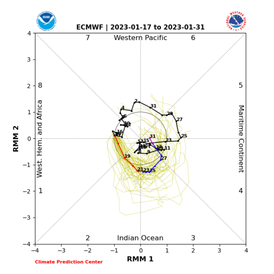
That large spike in phase 2 is the strongest on record for August.


It's had a knock-on effect too, marking the end of the MJO cycle that had otherwise looked to continue to the Maritime Continent by now.


Had that occurred, high pressure would have been encouraged to shift south-eastward, resulting in a very warm final week to the month. That's what gave rise to the heat plume scenarios that the models played with for a few days.


I'll chalk this month down as an unpredictable deviation caused by an inherently unlikely event. Not as extreme as the February debacle but pretty notable for a 2nd event in a single year.


With that in mind, I'll be fairly happy to finish within a degree Celsius of the final CET, despite it being less than ideal given the massive climbing act I've been tasked with since the dark days of February.


If you have any problems or queries relating to TWO you can Email [email protected] 🙂
https://twitter.com/peacockreports 
2021's Homeland Extremes:
T-Max: 30.4°C 21st Jul | T-Min: -6.8°C New Years Day! | Wettest Day: 34.1mm 2nd Oct | Ice Days: 2 (27th Jan & 8th Feb)
Keep Calm and Forecast On
ARTzeman
25 August 2021 10:21:36

Met Office Hadley       16.5c     Anomaly     0.6cc provisional to24th


Metcheck                    16.0c     Anomaly     -0.18c


Netweather                 16.6c     Anomaly     0.41c


Peasedown St John    15.6c     Anomaly    -0.5c. 


Some people walk in the rain.
Others just get wet.
I Just Blow my horn or trumpet
Hippydave
25 August 2021 20:02:31

Originally Posted by: Stormchaser 


I'm starting to fear that the final CET may actually be a little below 16.2°C. Yesterday was cloudier than forecast and then last night was a bit cooler than predicted in western parts.


<snip>


Anything lower than 16.2c gratefully received


TBH quite pleasantly surprised I'm not looking like I'll lose too much more ground this month - not sure I've been at the bottom of the guess range before and it was definitely looking like a very iffy guess for a while as the models toyed with a warmer end to the month, whereas I'd gambled on a cooler end with the longer nights assisting. 


Doesn't make up for the irritating collapse of Febs cold pattern you referenced but as someone who doesn't like hot weather, the current run of 20c by day and 12c or so by night IMBY is most welcome, just need some clear cool nights in the CET zone!


Home: Tunbridge Wells
Work: Tonbridge
ARTzeman
26 August 2021 10:17:05

Met Office Hadley     16.05c      Anomaly      0.6c provisional to 25th


Metcheck                  16.04c      Anomaly     -0.19c


Netweather               16.59c      Anomaly      0.4c


Peasedown St John   15.85c     Anomaly     -0.45c.


Some people walk in the rain.
Others just get wet.
I Just Blow my horn or trumpet
ARTzeman
27 August 2021 10:13:12

Met Office Hadley       16.5c      Anomaly     0.7c provisional to 26th


Metcheck                    15.99c    Anomaly     -0.25c


Netweather                 16.57c    Anomaly     0.38c


Peasedown St John    15.8c     Anomaly    -0.5c. 


Some people walk in the rain.
Others just get wet.
I Just Blow my horn or trumpet
Stormchaser
27 August 2021 10:32:12

Interesting that the daily provisional CET returns have continued to be in the mid-16s °C, despite further cool nights for western parts in general and days not making it much above 20°C at best.


Big question is whether this is just contributing to a larger correction downward for the actual CET? I've never been sure where exactly the contributing stations are located, as they don't seem to appear on the usual SYNOP/METAR lists. Hence the crude nature of my CET projections!


If you have any problems or queries relating to TWO you can Email [email protected] 🙂
https://twitter.com/peacockreports 
2021's Homeland Extremes:
T-Max: 30.4°C 21st Jul | T-Min: -6.8°C New Years Day! | Wettest Day: 34.1mm 2nd Oct | Ice Days: 2 (27th Jan & 8th Feb)
Keep Calm and Forecast On
Global Warming
27 August 2021 13:19:29

Looking much cooler now for the end of the month. CET estimate is now showing 15.95C for August.


IMAGE. Members enable at bottom of page


Chart 1


IMAGE. Members enable at bottom of page


Chart 2

Stormchaser
27 August 2021 18:42:26

Darn, I had that feeling!


Thanks for the update GW - but if you don't mind, I hope it finishes nearer your previous estimate (...somehow)!


The long-signalled high pressure turned up and so nearly located far enough south and east as had been looking most likely... but not quite, in the end. Several opportunities to slide SE a bit have come to nowt.


Honestly, I'm going to feel seriously cheated this month, but it is what it is.


If you have any problems or queries relating to TWO you can Email [email protected] 🙂
https://twitter.com/peacockreports 
2021's Homeland Extremes:
T-Max: 30.4°C 21st Jul | T-Min: -6.8°C New Years Day! | Wettest Day: 34.1mm 2nd Oct | Ice Days: 2 (27th Jan & 8th Feb)
Keep Calm and Forecast On
Bertwhistle
27 August 2021 21:44:58

Originally Posted by: Global Warming 


Looking much cooler now for the end of the month. CET estimate is now showing 15.95C for August.


IMAGE. Members enable at bottom of page


Chart 1


IMAGE. Members enable at bottom of page


Chart 2


So an average August really temp-wise, after a good June and July. Trumps really for the summer- about 16.4, equaling 2016 and therefore being the joint second highest summer CET since 2006? Not bad. It would put us ahead of 1984, 1990, 1994 and 2013 and not far behind 1989. 


Bertie, Itchen Valley.
'We'll never see 40 celsius in this country'.
ARTzeman
28 August 2021 10:16:26
Met Office Hadley 16.4c Anomaly 0.6c provisional to 27th
Metcheck 15.92c Anomaly -0.31c
Netweather 16.51c Anomaly 0.32c
Peasedown St John 15.68c Anomaly -0.62c.


Some people walk in the rain.
Others just get wet.
I Just Blow my horn or trumpet
ARTzeman
29 August 2021 10:15:49

Met Office Hadley       16.4c      Anomaly       0.5c provisional to 28th


Metcheck                    15.88c    Anomaly       -0.35c


Netweather                 16.46c    Anomaly        0.27c


Peasedown St John     15.61c   Anomaly     -0.61c.  


Some people walk in the rain.
Others just get wet.
I Just Blow my horn or trumpet
Users browsing this topic

Ads