Polar Low
25 November 2017 21:03:37

 yup decent winter charts


Originally Posted by: Gandalf The White 


Cold easterly at T+192


Gandalf The White
25 November 2017 21:26:10

Originally Posted by: Polar Low 


 yup decent winter charts


Yep, saw those - that's why I reckoned an ice day was a possibility above snow cover.  A decent cold air mass for the start of December.


Location: South Cambridgeshire
130 metres ASL
52.0N 0.1E


Karl Guille
25 November 2017 22:52:08
JMA 12z plays with the easterly airflow at T216 similar to the ECM at T192. Clearly this is a scenario of particular interest to me so I shall be keeping a close eye on this. Meanwhile its looking like being a cool or cold week ahead for the UK with a reasonable risk of snow even to low levels at times.

http://www.meteociel.fr/modeles/jma/runs/2017112512/J216-21.GIF?25-12 
St. Sampson
Guernsey
tallyho_83
25 November 2017 23:12:57


A long way off but what a weird looking chart! So messy and can anyone explain the direction the wind is coming from ha!? Secondly , I don't think i've ever seen the N. Atlantic so quiet ever before. Quite a block builidng off eastern Canada and into Greenland and stretching all the way down to the Azores!!


Home Location - Kellands Lane, Okehampton, Devon (200m ASL)
---------------------------------------
Sean Moon
Magical Moon
www.magical-moon.com


tallyho_83
25 November 2017 23:14:11

Originally Posted by: Karl Guille 

JMA 12z plays with the easterly airflow at T216 similar to the ECM at T192. Clearly this is a scenario of particular interest to me so I shall be keeping a close eye on this. Meanwhile its looking like being a cool or cold week ahead for the UK with a reasonable risk of snow even to low levels at times.

http://www.meteociel.fr/modeles/jma/runs/2017112512/J216-21.GIF?25-12


1080mb over Greenland!??


Home Location - Kellands Lane, Okehampton, Devon (200m ASL)
---------------------------------------
Sean Moon
Magical Moon
www.magical-moon.com


Gooner
25 November 2017 23:34:08

Control miles better than the Op


Loads to play for and these comments of standard stuff are utter crax 


Remember anything after T120 is really Just For Fun


Marcus
Banbury
North Oxfordshire
378 feet A S L


Polar Low
25 November 2017 23:52:29

we do need to be level head have to see how things pan out about pressure rises at grenny


Ecart type GEFS

Gandalf The White
26 November 2017 00:57:26

ECM 12z ensemble suite for London shoes that the op was in line with the mean until day 7 and then on the colder side for days 8 & 9.


if anything the mean is colder than previous runs beyond day 10 with a clear majority sticking with the cold regime.


Location: South Cambridgeshire
130 metres ASL
52.0N 0.1E


Gandalf The White
26 November 2017 01:04:44

Originally Posted by: Polar Low 


we do need to be level head have to see how things pan out about pressure rises at grenny


Ecart type GEFS


At that time I think that’s showing the uncertainties around the LP tracking through that area, not the subsequent pressure build, which is several days later (and mostly a surface feature)?


Location: South Cambridgeshire
130 metres ASL
52.0N 0.1E


moomin75
26 November 2017 07:01:41
ECM 0z is an absolute belter of a run. Crazy blocking and no fast way back to mild.
Witney, Oxfordshire
100m ASL
Nordic Snowman
26 November 2017 07:08:16

Originally Posted by: moomin75 

ECM 0z is an absolute belter of a run. Crazy blocking and no fast way back to mild.


Yes:-


http://www.wetterzentrale.de/en/topkarten.php?map=1&model=ecm&var=2&run=0&time=240&lid=OP&h=0&mv=0&tr=24#mapref


As I mentioned last night, a slightly less cold weekend followed by a N'ly reboot and with the Atlantic block looking solid, we could eventually end up with NE/E winds down the line.


Looking pretty wintry for the foreseeable.


Bjorli, Norway

Website 
Ally Pally Snowman
26 November 2017 07:08:51

Stunning ecm this morning pick of the bunch. With a great reload at day 9.  Siberian high Greenland high link up by day 10. Basically extremely blocked and looking like a protracted cold spell.


http://old.wetterzentrale.de/pics/Recm2401.html


Bishop's Stortford 85m ASL.
Whether Idle
26 November 2017 07:53:02

Originally Posted by: Ally Pally Snowman 


Stunning ecm this morning pick of the bunch. With a great reload at day 9.  Siberian high Greenland high link up by day 10. Basically extremely blocked and looking like a protracted cold spell.


http://old.wetterzentrale.de/pics/Recm2401.html


Yes, more synoptic eye-candy but Im afraid even that chart flatters to deceive.


I am again left with the impression that northerlies are relatively impotent, and notably less severe than they were in past decades, particularly the latter decades of the twentieth century.  I would be very interested to see what others think about this apparant reality.  In the spirit of exploring this idea, I attach an image (and a link) of a typical northerly synoptic set up from early December 1967 - 10 uppers in fact made it into Normandy, with -15c approaching the north of Scotland.  There was a notable snowstorm in Brighton:


http://www.wetterzentrale.de/reanalysis.php?uur=1800&var=2&nmaps=24&map=1&model=noaa&jaar=1967&maand=12&dag=08
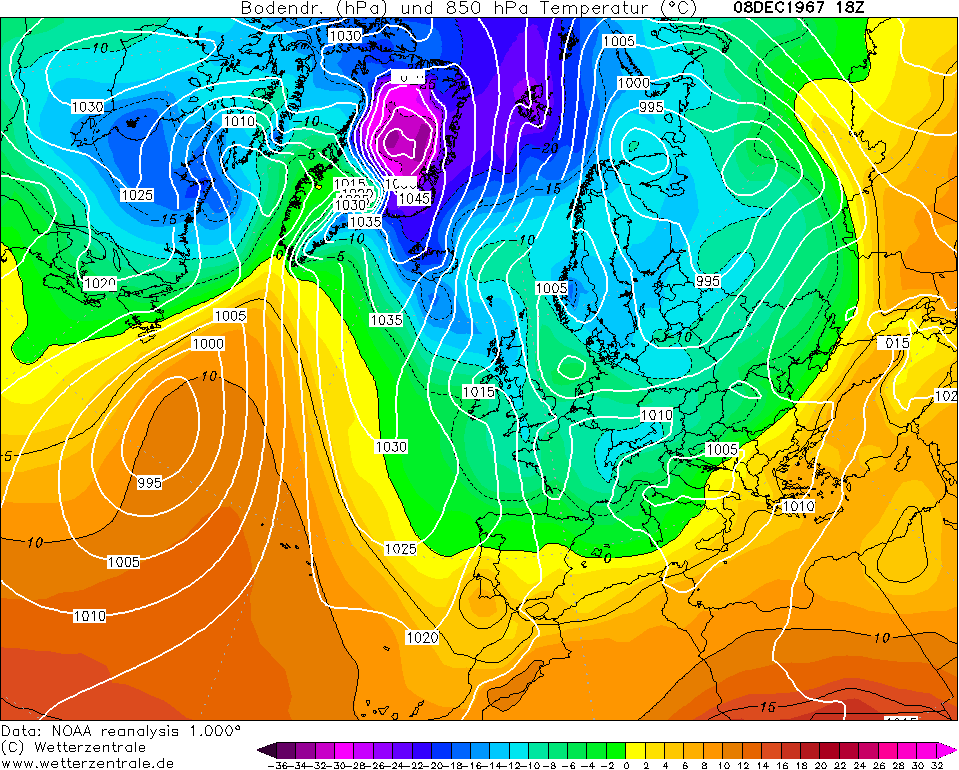

early dec 1967


A broadly  similar synoptic picture to the early December 2017 scenario as depicted by the ECM this morning, almost 50 years later to the day:


http://old.wetterzentrale.de/topkarten/fsecmeur.html


ecm dec 2017


Yes, I realise there are differences and no two synoptic situations are identical.  However, a not dissimilar outbreak of Arctic Air 50 years later and the -10 isotherm runs out at The Faroe Islands and the -5 isotherm gets tethered by the time it reaches the south coast.


It seems to me that the loss of ice in The Arctic and the melting of the Greenland Ice sheet are combining with positive SST anomalies and a warmer atmosphere (paricularly in high latitides) to make northerlies a much reduced force in the British Winter.  This is a pity, as they have been my favourite air mass (true Arctic Air) with its clairity and convection, and in the past, attendant chance of southern snow.


I realise that the two charts are different as the Greenalnd high is stronger in 1967 and the 2017 forecast is more of a mid Atlantic omega with a northern extension, but the differences in the reservoir of deep cold for us to tap into, are much reduced, sadly, in my opinion.


I am happy to have someone more knowledgeable than myself deconstruct my supposition, as it would be great see a similar Arctic outbreak as December 1967 brought us. Similarly, I would apprecaite some considered input from anyone knowledgeable who agrees.  Im not wanting to turn the MO thread into the climate forum! But I am irritated at the current northerlies not being what they used to be.  "The north wind doth blow and we shall have snow" could be replaced with "... and we shall have wintriness at high levels in the north".


Dover, 5m asl. Half a mile from the south coast.
Steve Murr
26 November 2017 07:58:36
I put this over the other side yest ( tried to paste it here but forum down )

Its really the reason why the models are responsing the way they are ATM -

https://www.netweather.tv/forum/topic/88576-winter-2017-2018-hopes-thoughts-and-any-early-forecasts/?page=18 

Thanks
Ally Pally Snowman
26 November 2017 07:59:58

Originally Posted by: Whether Idle 


Yes, more synoptic eye-candy but Im afraid even that chart flatters to deceive.


I am again left with the impression that northrlies are relatively impotent, and notably less severe than they were in past decades, particularly the latter decades of the twentieth century.  I would be very interested to see what others think about this apparant reality.  In the spirit of exploring this idea, I attach an image (and a link) of a typical northerly synoptic set up from early December 1967 - 10 uppers in fact made it into Normandy, with -15c approaching the north of Scotland.  There was a notable snowstorm in Brighton:


http://www.wetterzentrale.de/reanalysis.php?uur=1800&var=2&nmaps=24&map=1&model=noaa&jaar=1967&maand=12&dag=08


early dec 1967


A broadly  similar synoptic picture to the early December 2017 scenario as depicted by the ECM this morning, almost 50 years later to the day:


http://old.wetterzentrale.de/topkarten/fsecmeur.html


ecm dec 2017


Yes, I realise there are differences and no two synoptic situations are identical.  However, a not dissimilar outbreak of Arctic Air 50 years later and the -10 isothern runs out at The Faroe Islands and the -5 isotherm gets tethered by the time it reaches the south coast.


It seems to me that the loss of ice in The Arctic and the melting of the Greenland Ice sheet are combining with positive SST anomalies and a warmer atmosphere (paricularly in high latitides) to make northerlies a much reduced force in the British Winter.  This is a pity, as they have been my favourite air mass (true Arctic Air) with its clairity and convection.


I realise that the two charts are different as the Greenalnd high is stronger in 1967 and the 2017 forecast is more of a mid Atlantic omega with a northern extension, but the differences in the reservoir of deep cold for us to tap into, are much reduced, sadly, in my opinion.


The climate has warmed in the past 50 years especially  the Arctic region. So stands to reasons Northerlies won't pack quite so much of a punch as they used too. 


Bishop's Stortford 85m ASL.
Ally Pally Snowman
26 November 2017 08:03:05

Originally Posted by: Steve Murr 

I put this over the other side yest ( tried to paste it here but forum down )

Its really the reason why the models are responsing the way they are ATM -

https://www.netweather.tv/forum/topic/88576-winter-2017-2018-hopes-thoughts-and-any-early-forecasts/?page=18

Thanks


Good stuff Steve hope you are right. Ecm is certainly a stunner long term this morning 


Bishop's Stortford 85m ASL.
Tim A
26 November 2017 08:08:24
Lots of potential in the charts this morning for prolonged cold weather as we go into December.

One thing I have noticed is that the mid week northerly now looks less likely to feature NE or NNE winds with the trend to NNW winds instead which obviously has implications for shower distribution. This seems to be a common correction which keeps happening time after time .
Tim
NW Leeds
187m asl

 My PWS 
Gusty
26 November 2017 08:27:37

Originally Posted by: Tim A 

Lots of potential in the charts this morning for prolonged cold weather as we go into December.

One thing I have noticed is that the mid week northerly now looks less likely to feature NE or NNE winds with the trend to NNW winds instead which obviously has implications for shower distribution. This seems to be a common correction which keeps happening time after time .


It does Tim. The NNE 'ly element is now restricted to a 12-15 hour window late Thursday / early Friday. To be honest I am pleased to maintain the NNW'ly as it means a continuation of the sparkling polar sunshine. Much more preferable to the convective rain and sleet showers expected as a result of uppers on the wet, rather than white side of marginal.


I'm hopeful for a northerly reload next week having looked at this mornings output. I'm still very dubious as to how punchy it will be though for reasons demonstrated by young Phil (Whether Idle) a few minutes ago.


Steve - Folkestone, Kent
Current conditions from my Davis Vantage Vue
https://www.wunderground.com/dashboard/pws/IFOLKE11 
Join Kent Weather on Facebook.
https://www.facebook.com/stevewall69/ 


White Meadows
26 November 2017 08:31:39
nsrobins
26 November 2017 08:37:25

Originally Posted by: Tim A 

Lots of potential in the charts this morning for prolonged cold weather as we go into December.

One thing I have noticed is that the mid week northerly now looks less likely to feature NE or NNE winds with the trend to NNW winds instead which obviously has implications for shower distribution. This seems to be a common correction which keeps happening time after time .


The NE option was always a slim option, as was the potential for a ‘proper’ easterly. Northerly reloads are the favoured pattern to start winter. It’s a shame that as Idle has described a Northerly these days doesn’t seem to ‘cut the ice’ like it did in years gone by.


Neil
Fareham, Hampshire 28m ASL (near estuary)
Stormchaser, Member TORRO
Users browsing this topic

Ads