The Weather Outlook

Remove ads from site

Heavy Weather 2013
05 December 2025 11:44:48

With this being 7 days out, and looking at the progressive nature of the last 4 runs, this seems to be not far off from something half decent.

Probably just crumbs, but seems interesting:

https://www.wxcharts.com/api/contentwithoverlay/gfs_op/EUR_NA/850temp/2025-12-05T06:00:00Z/2025-12-11T18:00:00Z 

Originally Posted by: Russwirral 

Yeh, that really stood out for me as well.  A crumb at least. 


Mark

Beckton, E London

Less than 500m from the end of London City Airport runway.

idj20
05 December 2025 12:14:06

Just to follow on from above and to pick out some 'interesting' charts from the 6z:-
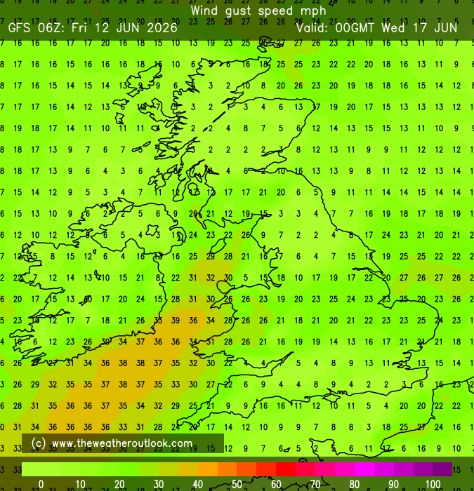
Windy IMBY:-

UserPostedImage

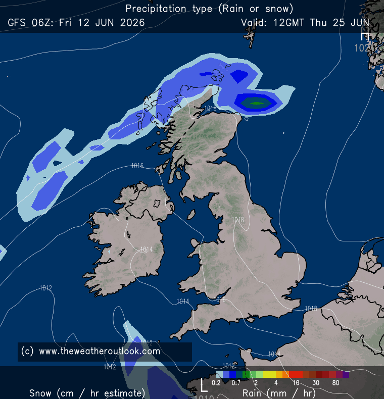
Wintry for some (it's deep FI and won't look like this next run obviously!):-

UserPostedImage

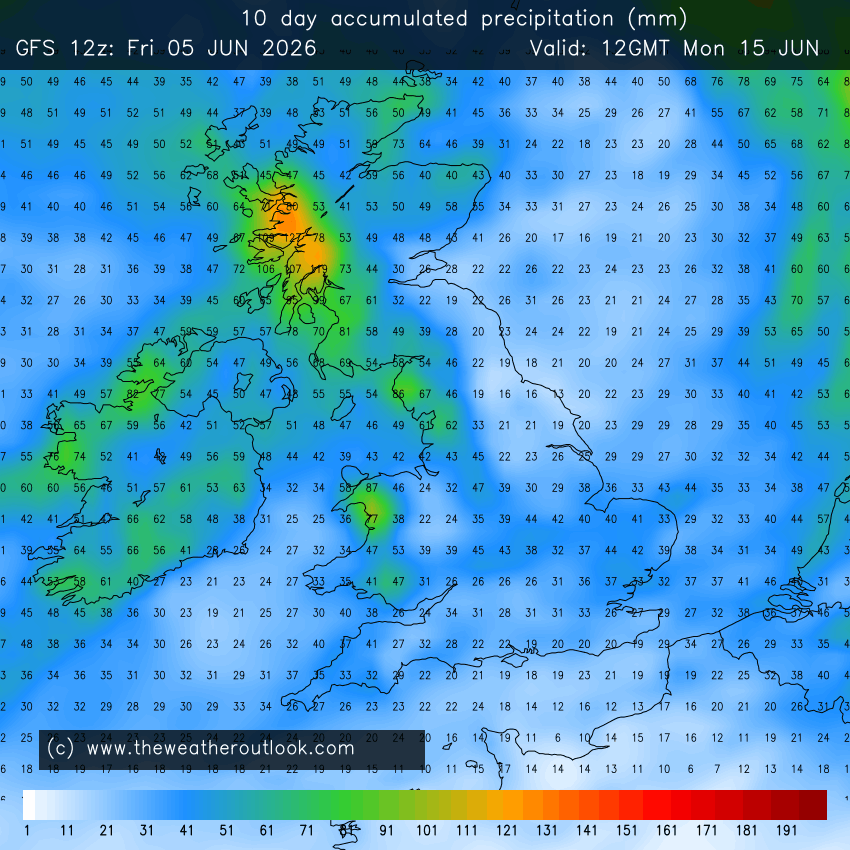
A wet 10 days ahead for most places, following a wet first few days of December:-

UserPostedImage

Slim pickings I guess but being odd I do enjoy proper rainfall, at least it means the weather's doing something and not just drizzly and mild. 

Originally Posted by: Hippydave 

I'm probably am sounding like a stuck record at this point but if that does come to fruition then just hope that lot clear away for my light trail trip by the evening. Or it doesn't make too much of a mess of it beforehand.


Home location: Folkestone Harbour.
tallyho_83
05 December 2025 12:26:52

It's actually insane how run after run, with only a couple of exceptions, have shown low pressure sat almost unmoving about halfway between Ireland and Iceland for literally the entire run. AIFS  is particularly strong on this. It feeds front after front over the UK.

The 0z GFS is one run that does try to break the cycle, by showing the blocking over the Arctic ridging southwards in thr 6-8 day period. But it's too far west to really impact us, and quickly gets pushed back north by the next bout of raging cyclogenesis over Baffin/Labrador.

Originally Posted by: Saint Snow 

Yes I notice that it is like it doesn't move does it? It will only move another to develop and do the same old thing!

Here @+102z - Low after low heading eastwards off eastern seaboard of USA/Canada - Cyclongenisis? High pressure to our south!

UserPostedImage

UserPostedImage

Same here, again one week on we see exact same pattern  @ +270z: - The low is between Iceland and Scotland moving NE only for another one to develop off N.E USA/Canada heading in exactly the same direction - between UK and Iceland!! Meanwhile the right over NW Canada stays strong brining cold arctic air to most of Central Plains and NE USA & Canada plunging them into the Freezer. Meanwhile high pressure remains to our south in exact same position as a week ago on 9th. - Result is large parts of Europe are well above normal with many countries in double figures and some in mid to high teens and only areas around freezing is northern Scandinavia. 

UserPostedImage

UserPostedImage


Home Location - Vixen Tor Close, Okehampton, Devon (221m ASL)

---------------------------------------

Sean Moon

Magical Moon

www.magical-moon.com

Jiries
05 December 2025 12:47:31

Yes I notice that it is like it doesn't move does it? It will only move another to develop and do the same old thing!

Here @+102z - Low after low heading eastwards off eastern seaboard of USA/Canada - Cyclongenisis? High pressure to our south!

UserPostedImage

UserPostedImage

Same here, again one week on we see exact same pattern  @ +270z: - The low is between Iceland and Scotland moving NE only for another one to develop off N.E USA/Canada heading in exactly the same direction - between UK and Iceland!! Meanwhile the right over NW Canada stays strong brining cold arctic air to most of Central Plains and NE USA & Canada plunging them into the Freezer. Meanwhile high pressure remains to our south in exact same position as a week ago on 9th. - Result is large parts of Europe are well above normal with many countries in double figures and some in mid to high teens and only areas around freezing is northern Scandinavia. 

UserPostedImage

UserPostedImage

Originally Posted by: tallyho_83 

Every time we see the deep cold in USA make me yawn and bored of it but puzzling how they still obtain such low temps with thsi current GW taking in place?  If they do get those low 850's on the charts surely Europe that used to get those should entitled to get it since they are also continent as USA landmass.   -10C to -15C was often reached over the UK before now barely below -5C so USA should do the same not getting lower than -10C by now with GW in place.

Brian Gaze
05 December 2025 12:58:25
ECM IFS HD (1920x1080) charts showing precipitation type, 850hPa temps and MSLP are now available out to t+360 hours if you've got a login.

https://www.theweatheroutlook.com/twodata/ecmhr.aspx 

They appear under the Europe tab.

 UserPostedImage


Brian Gaze

Berkhamsted

TWO Buzz - get the latest news and views 

"I'm not socialist, I know that. I don't believe in sharing my money." - Gary Numan

Saint Snow
05 December 2025 14:24:13

850s are alot more blue than green on this mornings output across ECM and GFS

Id say it was the beginning of a new trend, but actually, Im just hoping its the end of the current trend.

Originally Posted by: Russwirral 

With this being 7 days out, and looking at the progressive nature of the last 4 runs, this seems to be not far off from something half decent.

Probably just crumbs, but seems interesting:

https://www.wxcharts.com/api/contentwithoverlay/gfs_op/EUR_NA/850temp/2025-12-05T06:00:00Z/2025-12-11T18:00:00Z 

Originally Posted by: Russwirral 

Is it just me but is the 06z trying to do something different at 144hrs?

Originally Posted by: Heavy Weather 2013 

Two GFS runs on the bounce that show southward-ridging from the Arctic splicing through the North Atlantic 'perma-low' late in the higher-res part of the run.

Both slink back to abysmal, low pressure-dominated crap as we move through the lower-res.

But, as you both say, the first inklings of hopefully more seasonal conditions.


Martin

Home: St Helens (26m asl) Work: Manchester (75m asl)

A TWO addict since 14/12/01

"How can wealth persuade poverty to use its political freedom to keep wealth in power? Here lies the whole art of Conservative politics."

Aneurin Bevan

Quantum
05 December 2025 14:54:07
P28 on the GFS6Z seems to be one of the first 'extreme cold' ensembles of the winter with -18C recorded briefly at the T850hpa level.


25/26 (850hpa temp) 11 days snow/sleet falling

18/11 (-4) 19/11 (-6) 20/11 (-6) 01/01 (-7) 04/01 (-10) 10/01 (-7) 11/01 (-3) 30/01 (-1) 13/02 (-6) 15/02 (-4) 18/02 (-6)

24/25 10d

18/11 (-6) 19/11 (-6) 23/11 (-2) 22/12 (-5) 04/01 (-5) 05/01 (0)14/02 (0) 15/02 (0)12/03 (-6) 13/03 (-6)

23/24 8d

29/11 (-6) 30/11 (-6) 02/12 (-5) 03/12 (-5) 04/12 (-3) 16/01 (-3) 18/01 (-8)08/02 (-5)

22/23 7d

18/12 (-1)06/03 (-6) 08/03 (-8) 09/03 (-6) 10/03 (-8) 11/03 (-5) 14/03 (-6)

21/22 12d

Matty H
05 December 2025 16:00:53

Yes, climate change is generally good for the UK  but a disaster for other parts of the world as we have already seen in Asia recent weeks, which will fuel climate refugees forced flee to western countries which someone like you will hate

So its not encouraging. It is a disaster for us all

Originally Posted by: The Beast from the East 

Who mentioned climate change. Just referring to lovely mild temps 😵‍💫

Cold weather kills more people than hot. Fortunately there’s no clear signal of any cold weather at the moment 


Yate, Nr Bristol

TBFTEIARBSC

Quantum
05 December 2025 16:23:33
12Z pattern on the GFS looking better.

By the 13th December (relative to the GFS) the tropospheric polar vortex is weaker over Canada, stronger over Siberia; and the ridge over greenland is stronger.

Some quite strong trends today towards some more interesting patterns mid month.


25/26 (850hpa temp) 11 days snow/sleet falling

18/11 (-4) 19/11 (-6) 20/11 (-6) 01/01 (-7) 04/01 (-10) 10/01 (-7) 11/01 (-3) 30/01 (-1) 13/02 (-6) 15/02 (-4) 18/02 (-6)

24/25 10d

18/11 (-6) 19/11 (-6) 23/11 (-2) 22/12 (-5) 04/01 (-5) 05/01 (0)14/02 (0) 15/02 (0)12/03 (-6) 13/03 (-6)

23/24 8d

29/11 (-6) 30/11 (-6) 02/12 (-5) 03/12 (-5) 04/12 (-3) 16/01 (-3) 18/01 (-8)08/02 (-5)

22/23 7d

18/12 (-1)06/03 (-6) 08/03 (-8) 09/03 (-6) 10/03 (-8) 11/03 (-5) 14/03 (-6)

21/22 12d

Gandalf The White
05 December 2025 16:33:40

Who mentioned climate change. Just referring to lovely mild temps 😵‍💫

Cold weather kills more people than hot. Fortunately there’s no clear signal of any cold weather at the moment 

Originally Posted by: Matty H 

True for us but not for hot parts of the world where conditions have gone from challenging to dangerous.


Location: South Cambridgeshire

130 metres ASL

52.0N 0.1E


nsrobins
05 December 2025 16:36:01
And the 12Z ICON is a proper tease towards the end with maybe GEM going the same way?

Small steps Ellie 😉


Neil

Fareham, Hampshire 28m ASL (near estuary)

Stormchaser, Member TORRO

warrenb
05 December 2025 16:49:20
Something is stirring, started to see it yesterday. Not there yet, but stepping stones.
Russwirral
05 December 2025 17:02:51
I might be spotting water mirages in the desert here

But could you say the GH is a little bit more powerful on the last few runs?  

Could this be the start of a SSW response in the models?  Far from a Cold spell, but the last few runs just seem to want so run the LPs a little further south and have more umph coming from the north?


Heavy Weather 2013
05 December 2025 17:11:58
Another interesting GFS. Feels like it’s definitely trying something new.
Mark

Beckton, E London

Less than 500m from the end of London City Airport runway.

doctormog
05 December 2025 17:24:26
I still think the northern hemisphere synoptics are interesting in the medium term, however a strong jet blasting across the Atlantic would probably mean that wintry weather would stay to the north.  Meanwhile before then some notably mild weather, especially further south.
Brian Gaze
05 December 2025 21:34:36
This is a remarkable update. A big or perhaps (in this context) huge positive anomaly over the 15 day period, but 2 big outliers.

UserPostedImage


Brian Gaze

Berkhamsted

TWO Buzz - get the latest news and views 

"I'm not socialist, I know that. I don't believe in sharing my money." - Gary Numan

tallyho_83
06 December 2025 00:06:17
Wow! Look how warm it will be across all of Europe on Tuesday midday GMT!?

UserPostedImage


Home Location - Vixen Tor Close, Okehampton, Devon (221m ASL)

---------------------------------------

Sean Moon

Magical Moon

www.magical-moon.com

BJBlake
06 December 2025 00:23:12
GFS Pub Run showing a Euro Slug High Rearing up and engulfing the UK. maybe we’ll be having Christmas on the beach perhaps, like down under!!
Brecklands, South Norfolk 28m ASL
tallyho_83
06 December 2025 00:33:35
18z GFS Op shows repeated modest warmings of the Stratosphere at 10hpa commencing over Siberia and penetrating into Arctic regions I notice if you look at temperature chart from N. Hemisphere view: - Stretching the PV as you can see, so one to keep an eye on! I know I am clutching @ straws but never know, this could be a precursor to an impending SSW!? At least there is something more interesting to talk from a cold and wintry perspective rather than mild and wet weather every day! 

+180z

UserPostedImage

+240z

UserPostedImage

+330z

UserPostedImage

+360z:

UserPostedImage


Home Location - Vixen Tor Close, Okehampton, Devon (221m ASL)

---------------------------------------

Sean Moon

Magical Moon

www.magical-moon.com

The Beast from the East
06 December 2025 03:08:32

GFS Pub Run showing a Euro Slug High Rearing up and engulfing the UK. maybe we’ll be having Christmas on the beach perhaps, like down under!!

Originally Posted by: BJBlake 

That always far more likely than cold.  This week is going to feel like Spring.  Is still have roses in December, first time ever.  If we cant have cold, then let it be crazy warm and see how nature reacts. 


Purley, Surrey, 70m ASL

"We have some alternative facts for you"

Kelly-Ann Conway - former special adviser to the President

Ally Pally Snowman
06 December 2025 07:00:27
At least GEM is in the Christmas spirit. 

https://www.meteociel.fr/modeles/geme_cartes.php?&ech=216&mode=0 


Bishop's Stortford 85m ASL.
nsrobins
06 December 2025 07:02:02
GEM again flying the ragged flag for winter with UKMO possibly going the same way. Whilst there’s options other than raging zonality on the table then you have to keep believing something might break us out of the rather gloomy (and wet) outlook.
Neil

Fareham, Hampshire 28m ASL (near estuary)

Stormchaser, Member TORRO

Brian Gaze
06 December 2025 07:42:22
I've posted this one in the fantasy thread, but worth sticking here too. GEM often verifies better than GFS.

UserPostedImage

UserPostedImage


Brian Gaze

Berkhamsted

TWO Buzz - get the latest news and views 

"I'm not socialist, I know that. I don't believe in sharing my money." - Gary Numan

Retron
06 December 2025 07:49:52

I've posted this one in the fantasy thread, but worth sticking here too. GEM often verifies better than GFS.

Originally Posted by: Brian Gaze 

Sadly not in terms of snowcover though, the model has a marked bias towards generating phantom cover! (Mind you, 99% of what's shown beyond a couple of days turns out to be fantasy snowcover down here. 😁)


Leysdown, north Kent

Remove ads from site