The Weather Outlook

Remove ads from site

Russwirral
12 December 2024 17:59:50
I would go as far as to say something is brewing, all models are or recently have alluded to it.  Question of time and runs to resolve if its true or not.
Retron
  • Retron
  • Advanced Member Topic Starter
12 December 2024 18:12:31

I would go as far as to say something is brewing, all models are or recently have alluded to it.  Question of time and runs to resolve if its true or not.

Originally Posted by: Russwirral 

I wouldn't disagree with that, having had a quick skim through the 12z GEFS. The control has a deep low over the south of the UK, with easterlies, and as for this particular chart - pretty much perfect, I would suggest!

https://images.meteociel.fr/im/20/15738/gens_8_2_312ihi3.png 

UserPostedImage

https://www.meteociel.fr/modeles/gefs_cartes.php?ech=312&code=8&mode=0&carte=0&ext=0 

(Widespread sleet or snow from a very unstable WNW'ly flow)


Leysdown, north Kent
CField
13 December 2024 04:55:15
After yesterday's  blip of excitement back to reality with return of Mighty Heights to the South.A 1988 style Chrtmas looks very likely now.
Favourite snowstorm

Famous channel low

Dec 31st 1978

Hastings East Sussex

Foot of level snow severe drifting

Next day max temp -4 degrees Celsius

doctormog
13 December 2024 06:19:54

After yesterday's  blip of excitement back to reality with return of Mighty Heights to the South.A 1988 style Chrtmas looks very likely now.

Originally Posted by: CField 

One glance at the ensembles for 12 days out shows that no one scenario is currently “very likely”.


Retron
  • Retron
  • Advanced Member Topic Starter
13 December 2024 06:23:42
A mild SW'ly flow covers the UK in today's GFS run, with a large high extending from the Azores to the Alps and onwards across Turkey.

UserPostedImage

https://images.meteociel.fr/im/43/7347/gfs_0_288ysb7.png 

The control of the GEFS has strong westerlies with complex low pressure to the north, with sleet or snow across much of Scotland. A ridge then builds in from the west as the low clears away ESE'wards.

The members of the GEFS continue to be mixed, with a westerly bias. Today's clusters include:

Anticyclonic SW'lies: 5

Ridge to west with cold NW'lies: 5

High or ridge close to SW, westerlies: 4

Cyclonic SW'lies: 3

Ridge or high over Scotland/NI, NE'lies elsewhere: 3

Ridge to west, cold northerlies: 3

Trough crossing UK: 2

Ridge from east: 2

Ridge from south: 2

Complex low to north, cold westerlies: 1

Of note is that every member shows snow already on the ground over parts of Scotland, many quite widely. Another trend that's appeared this morning is for several members to show the UK lying under a weak ridge, a link between a Scandinavian High and the Azores High.

The standout run this morning is number 20, which shows an unstable northerly flow over the UK with fairly widespread sleet or snow. There is already snow on the ground for around a third of the UK.

UserPostedImage

https://images.meteociel.fr/im/87/24131/gens_20_1_288spe7.png 


Leysdown, north Kent
Retron
  • Retron
  • Advanced Member Topic Starter
13 December 2024 06:29:13

One glance at the ensembles for 12 days out shows that no one scenario is currently “very likely”.

Originally Posted by: doctormog 

Spot on - it's why I include the ensembles in these daily run-downs, as they're great for ascertaining how likely the op is to come off. All you can really say at the moment is that it's probable that winds from a westerly quarter will cover the UK, but there's low confidence in whether they'll be cyclonic, anticyclonic, or even a cold (i.e. snowy) NW'ly. And even then, there are still plenty of other scenarios on offer - the appearance in several of a high to the NE piques my interest, for example, even if it's less exciting for those in the north and/or west.

I'm certainly not going to say it's going to be a green and miserable Christmas yet, not that I would even if the ensembles were throwing their weight behind that outcome! The reason is - it's still 12 days out. We wouldn't trust a day 10 chart and we certainly shouldn't trust a single day 12 op chart. They're a rough guide, nothing more, at this range.

By this time next week I suspect we'll have decent confidence in the outcome, but that's a heck of a long way off in model terms!


Leysdown, north Kent
White Meadows
13 December 2024 07:11:28
ECM throws up a decent Northerly this morning, emerging for Christmas. 

Likely an outlier and unsupported at this stage. 

Quantum
13 December 2024 07:14:16
Somewhat curious pattern. The 500hpa geopotentials don't get much worse; flat with very low heights in the canadian north and high heights over the Azores. Yet the MSLP contours are really making the best of a terrible situation with some cold incursions despite the abysmal pattern.


25/26 (850hpa temp) 11 days snow/sleet falling

18/11 (-4) 19/11 (-6) 20/11 (-6) 01/01 (-7) 04/01 (-10) 10/01 (-7) 11/01 (-3) 30/01 (-1) 13/02 (-6) 15/02 (-4) 18/02 (-6)

24/25 10d

18/11 (-6) 19/11 (-6) 23/11 (-2) 22/12 (-5) 04/01 (-5) 05/01 (0)14/02 (0) 15/02 (0)12/03 (-6) 13/03 (-6)

23/24 8d

29/11 (-6) 30/11 (-6) 02/12 (-5) 03/12 (-5) 04/12 (-3) 16/01 (-3) 18/01 (-8)08/02 (-5)

22/23 7d

18/12 (-1)06/03 (-6) 08/03 (-8) 09/03 (-6) 10/03 (-8) 11/03 (-5) 14/03 (-6)

21/22 12d

Brian Gaze
13 December 2024 07:53:13
The animation shows the GEFS 00Z snow depth forecasts for Christmas Day.

UserPostedImage


Brian Gaze

Berkhamsted

TWO Buzz - get the latest news and views 

"I'm not socialist, I know that. I don't believe in sharing my money." - Gary Numan

Jiries
13 December 2024 09:43:11

The animation shows the GEFS 00Z snow depth forecasts for Christmas Day.

UserPostedImage

Originally Posted by: Brian Gaze 

Some reached to the Midlands, surely this boring nasty HP that brought lot of rain and clouds to go away before Xmas.  Any pattern that not have HP over us is much welcome.   Like what Darren posted above Cold NW now stand at 5 so hope it increase further as we do well with NW polar air that bring show showers here, more sunshine, colder nights combo.

CField
13 December 2024 09:52:14

One glance at the ensembles for 12 days out shows that no one scenario is currently “very likely”.

Originally Posted by: doctormog 

Probably a week early to make that statement I agree........hope my enterpretation of this mornings 0z is wrong....this winter is beginning to feel deja vu to me again hope I am mistaken..


Favourite snowstorm

Famous channel low

Dec 31st 1978

Hastings East Sussex

Foot of level snow severe drifting

Next day max temp -4 degrees Celsius

Ally Pally Snowman
13 December 2024 10:51:20

Probably a week early to make that statement I agree........hope my enterpretation of this mornings 0z is wrong....this winter is beginning to feel deja vu to me again hope I am mistaken..

Originally Posted by: CField 

I think its a pretty safe bet, all of the models ensembles look shocking for cold and snow in the South. The zonal train looks to be cranking up as well. V poor but not surprising. 


Bishop's Stortford 85m ASL.
Retron
  • Retron
  • Advanced Member Topic Starter
13 December 2024 11:00:09

I think its a pretty safe bet, all of the models ensembles look shocking for cold and snow in the South. The zonal train looks to be cranking up as well. V poor but not surprising. 

Originally Posted by: Ally Pally Snowman 

A safe bet that it'll look like Christmas 1988? I'd say it's pretty unlikely TBH. The closest in the current ensembles is the anticyclonic SW'ly cluster, and that's very much in the minority. A more general SW'ly flow is reasonably likely, but even that's still far from nailed on at the moment. Something from SW to NW (i.e. a westerly quarter) being likely is all you can say at the moment.

Anything else strays into the realms of "it always sucks, so it will this year too" territory! 🙂

As a reminder, here's what Christmas Day 1988 looked like. It was a mostly dry day down here - just a trace of rain, with a max of 12 , min of 9.1 and a mean pressure of 1025hPa at the London Weather Centre. Winds would have been SSW'ly, something which isn't really shown in the current output.

https://modeles3.meteociel.fr/modeles/reana/1988/archives-1988-12-25-12-0.png 

UserPostedImage


Leysdown, north Kent
Taylor1740
13 December 2024 11:13:10

I think its a pretty safe bet, all of the models ensembles look shocking for cold and snow in the South. The zonal train looks to be cranking up as well. V poor but not surprising. 

Originally Posted by: Ally Pally Snowman 

Yeah basically no chance at all of a proper cold spell until at least the beginning of January I would say, brief colder interludes at best.


NW Leeds - 150m amsl
Ally Pally Snowman
13 December 2024 11:15:38

A safe bet that it'll look like Christmas 1988? I'd say it's pretty unlikely TBH. The closest in the current ensembles is the anticyclonic SW'ly cluster, and that's very much in the minority. A more general SW'ly flow is reasonably likely, but even that's still far from nailed on at the moment. Something from SW to NW (i.e. a westerly quarter) being likely is all you can say at the moment.

Anything else strays into the realms of "it always sucks, so it will this year too" territory! 🙂

As a reminder, here's what Christmas Day 1988 looked like. It was a mostly dry day down here - just a trace of rain, with a max of 12 , min of 9.1 and a mean pressure of 1025hPa at the London Weather Centre. Winds would have been SSW'ly, something which isn't really shown in the current output.

https://modeles3.meteociel.fr/modeles/reana/1988/archives-1988-12-25-12-0.png 

UserPostedImage

Originally Posted by: Retron 

I admire that you have any optimism at all atm, but when you have 50 ensembles that barely go below -5c 850s for the next 2 weeks you know it's an up hill struggle for anything interesting snow wise.

https://www.wetterzentrale.de/en/show_diagrams.php?geoid=50893&model=ecm&var=2&run=0&lid=ENS&bw=1 


Bishop's Stortford 85m ASL.
Retron
  • Retron
  • Advanced Member Topic Starter
13 December 2024 11:24:15

I admire that you have any optimism at all atm, but when you have 50 ensembles that barely go below -5c 850s for the next 2 weeks you know it's an up hill struggle for anything interesting snow wise.

https://www.wetterzentrale.de/en/show_diagrams.php?geoid=50893&model=ecm&var=2&run=0&lid=ENS&bw=1 

Originally Posted by: Ally Pally Snowman 

As I write this it's 2.7 outside, well below the 5 that GFS has for right now, or even the 4 that MetO has. None of the 6z GEFS have anything near that cold either, they're mostly 5s with the odd 4. And that's just a couple of hours out, last-minute things can pop up.

Until we get within the 10 day range I'm not going to take what the models show too seriously. If in the next 7 days they gradually firm up on a mild SW'ly flow so be it, but I'd say it's still far from a foregone conclusion at this stage.


Leysdown, north Kent
Saint Snow
13 December 2024 11:42:55

A safe bet that it'll look like Christmas 1988? I'd say it's pretty unlikely TBH. The closest in the current ensembles is the anticyclonic SW'ly cluster, and that's very much in the minority. A more general SW'ly flow is reasonably likely, but even that's still far from nailed on at the moment. Something from SW to NW (i.e. a westerly quarter) being likely is all you can say at the moment.

Anything else strays into the realms of "it always sucks, so it will this year too" territory! 🙂

As a reminder, here's what Christmas Day 1988 looked like. It was a mostly dry day down here - just a trace of rain, with a max of 12 , min of 9.1 and a mean pressure of 1025hPa at the London Weather Centre. Winds would have been SSW'ly, something which isn't really shown in the current output.

https://modeles3.meteociel.fr/modeles/reana/1988/archives-1988-12-25-12-0.png 

UserPostedImage

Originally Posted by: Retron 

thank you for being a calm voice of studied reason.


Martin

Home: St Helens (26m asl) Work: Manchester (75m asl)

A TWO addict since 14/12/01

"How can wealth persuade poverty to use its political freedom to keep wealth in power? Here lies the whole art of Conservative politics."

Aneurin Bevan

Lionel Hutz
13 December 2024 14:24:00

thank you for being a calm voice of studied reason.

Originally Posted by: Saint Snow 

I'll second that, Saint. I very much appreciate Darren setting out the various different possibilities. It may end up mild and boring but no point in giving up when a range of outcomes is still perfectly possible.


Lionel Hutz

Nr.Waterford , S E Ireland

68m ASL


overland
13 December 2024 14:26:04

A safe bet that it'll look like Christmas 1988? I'd say it's pretty unlikely TBH. The closest in the current ensembles is the anticyclonic SW'ly cluster, and that's very much in the minority. A more general SW'ly flow is reasonably likely, but even that's still far from nailed on at the moment. Something from SW to NW (i.e. a westerly quarter) being likely is all you can say at the moment.

Anything else strays into the realms of "it always sucks, so it will this year too" territory! 🙂

As a reminder, here's what Christmas Day 1988 looked like. It was a mostly dry day down here - just a trace of rain, with a max of 12 , min of 9.1 and a mean pressure of 1025hPa at the London Weather Centre. Winds would have been SSW'ly, something which isn't really shown in the current output.

https://modeles3.meteociel.fr/modeles/reana/1988/archives-1988-12-25-12-0.png 

UserPostedImage

Originally Posted by: Retron 

Too much negativity both here and on Netweather. Looking at the GEFS although there is plenty of mild options there is a cluster around -5 850hPa which suggests something vaguely festive. I appreciate people are looking for a proper wintery spell with deep cold but that's always unlikely and the current setup looks a lot better than some of the horror shows of previous years.


Mumbles, Swansea. 80m asl
doctormog
13 December 2024 16:56:11
It could very easily turn out to be a (very) mild Christmas Day, but one glance at the.option on the latest 12z op GFS run suggests that at this range other options are definitely still on the table (as Darren’s daily posts illustrate nicely).

https://www.wetterzentrale.de/maps/GFSOPEU12_294_1.png 

It probably goes without saying to expect something different on the next GFS op run (and most of the ensemble members), but I said it anyway.


Brian Gaze
13 December 2024 16:57:42
GFS 12Z does the trick in large parts of the UK.

UserPostedImage

Snow depths here: 

https://www.theweatheroutlook.com/twodata/gfs.aspx?run=12&charthour=276&chartname=uksnowdepth&chartregion=uk&charttag=Snow%20depth 


Brian Gaze

Berkhamsted

TWO Buzz - get the latest news and views 

"I'm not socialist, I know that. I don't believe in sharing my money." - Gary Numan

Retron
  • Retron
  • Advanced Member Topic Starter
13 December 2024 17:19:47
Yes, the 12z GFS is the sort of run that should cheer up those who are expecting a green, miserable Christmas! Compared with the recent ensemble output it's on the far end of what's possible, but not entirely unsupported. The fact the jet changes start as soon as 144 shows there's still plenty of water to flow under the bridge.

I'd take it, anyway. No snow here on Christmas Day IMBY, but it snows a couple of days beforehand - nice and festive. Snow at this time of year, with all the lights twinkling away, always seems more special.

Will it survive to the 0z runs? I doubt it, but the fun thing is you never can tell. I doubt anyone was expecting the swing on the 12z GFS today, put it that way. 🙂


Leysdown, north Kent
Retron
  • Retron
  • Advanced Member Topic Starter
13 December 2024 18:10:25
The 12z GEFS control is interesting too, as it brings-10 850s, NE'lies and snow at lunchtime on Christmas Day across Kent. It's not a snowy run elsewhere, but again shows the potential lurking in the pack - as that's about as far away from mild SW'lies as you could get!

UserPostedImage

https://images.meteociel.fr/im/17/12743/gens_0_0_288rmo1.png 


Leysdown, north Kent
Jiries
14 December 2024 05:34:25

The 12z GEFS control is interesting too, as it brings-10 850s, NE'lies and snow at lunchtime on Christmas Day across Kent. It's not a snowy run elsewhere, but again shows the potential lurking in the pack - as that's about as far away from mild SW'lies as you could get!

UserPostedImage

https://images.meteociel.fr/im/17/12743/gens_0_0_288rmo1.png 

Originally Posted by: Retron 

See the massive colder pool from the NW want to move here and seem more colder than from the east? East normally colder than NW cold.  Just if we get days of exact cold polar NW flow and fast enough to travel shortest sea crossing from Greenland to here minus 16 uppers would be here with deep snow cover due to days of snow showers pilling in.  My area also get decent snow showers as did in 2021 from the wash at NE flow.

Retron
  • Retron
  • Advanced Member Topic Starter
14 December 2024 05:55:53
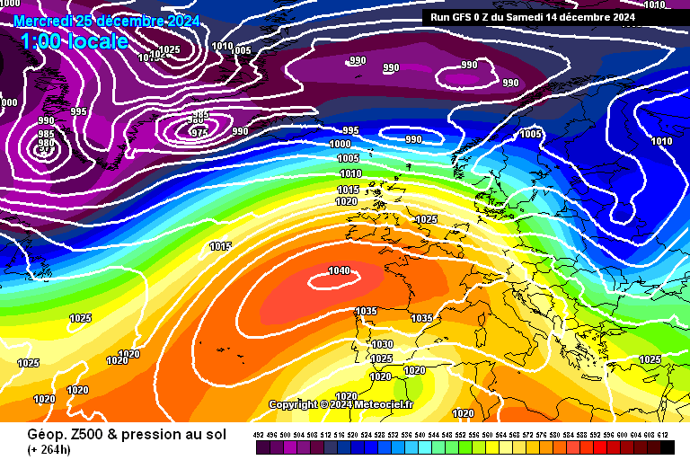
This morning's GFS serves up a mild westerly flow across the UK, with high pressure to the immediate SW. There's rain over NW Scotland and this persists all day, with the rest of the UK being largely dry.

UserPostedImage

https://images.meteociel.fr/im/51/12162/gfs_0_264lmm3.png 

The GEFS control has an elongated high from the Azores to the Alps, with a weak trough approaching Scotland. Winds are a mix of WSW'lies and SW'lies as a result.

The other members of the GEFS continue to paint a variety of pictures today. They include:

Anticyclonic SW'lies: 5

High to SW, westerlies: 3

High or ridge over England and Wales, SW'lies to north: 3

Weak ridge over UK, westerlies: 3

Ridge to west, NW'lies: 2

Ridge from east, NE'lies over England and Wales: 2

Ridge from south, light winds: 2

Low to north, westerlies: 2

Complex low pressure over and surrounding UK: 2

There are plenty of one-offs, including cyclonic SW'lies and a trough crossing the UK.

The overall picture remains one of winds from a westerly quarter being the most likely, with high pressure close to the UK. Several members position the high/ridge to bring colder conditions, and a few members continue to show a cold, wintry picture with low pressure nearby.

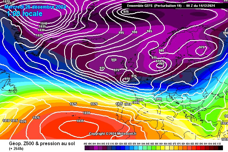
Today's standout member is 19, which has snow moving southwards across the UK during Christmas Day in association with complex low pressure.

UserPostedImage

https://images.meteociel.fr/im/31/24379/gens_19_1_264rqm6.png 


Leysdown, north Kent

Remove ads from site