ENE'lies are better in terms of convective potential, you get a frictional effect from the narrowing of the Thames estuary and it means heavier snow. Similarly ESE'lies are best for southern Essex.
Anything due east or further south ends up coldest of all, due to the lack of boundary modification. Traditionally you'd want an east or ESE'ly feed to bring essentially unmodified Continental cold, then a switch north of east to bring in snow... and when the breakdown came from the west, you could get away with 850s of zero and 500-1000 thicknesses of 540, just as they look for in the States.
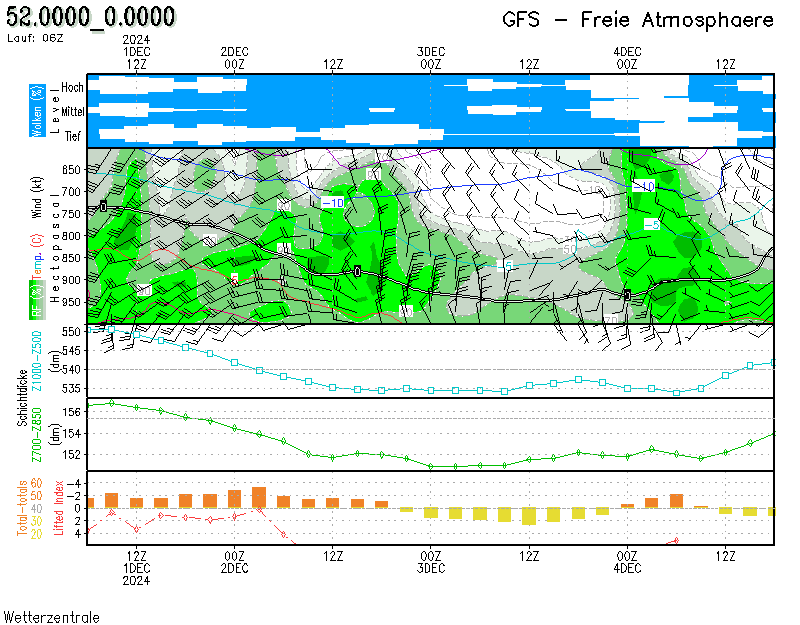
Without that cold boundary layer then you're stuck with the old classics: a minimum of -5 at 850, 522 thickness (which is the 50/50 rain/snow boundary according to research on usw back in the day), or better still -10 and below 520 respectively.
It's a shame the old Meteostar sampled pages no longer work, but old-timers will remember the WZ meteograms - they still work, and yes, "London" is now 50 miles to the north! Here's the 6z GFS output, I find the thickness and 850 sections uniquely useful.
The original URL is here:
https://www.wetterzentrale.de/en/show_diagrams.php?geoid=49069&model=gfs&var=212&run=6&lid=OP&bw=1
https://ukwct.org.uk/weather/GFS_U.png
Originally Posted by: Retron