The Weather Outlook

Remove ads from site

TimS
  • TimS
  • Advanced Member
06 February 2021 12:02:32


We are at 180m above Wye. I’m expecting a significant amount of snow here.

Originally Posted by: Justin W 

Do you have a weather station so we can see how temps develop?

The weather station at my vineyard site in Pett Bottom is in a frost hollow (I know, not ideal for vines but it’s only at the bottom) at 80m with hilltops around 150m around in a dry valley, so I’m expecting some very cold minima if we get a clear high pressure later next week. It’s also pretty wet in winter so I’d expect high snow totals.

My weather station link below:

https://www.wunderground.com/dashboard/pws/ICANTE19

Only worry is the internet link is solar / battery powered so if the panels get snow covered for a few days I might lose power. 


Brockley, South East London 30m asl
henny
06 February 2021 12:05:46


Yep. Even the Met Office have been horribly wrong with some of their snow forecasts for my location this year. A good few of them were either undercooked or not forecast altogether. My advice with this spell would be just watch the radar and take it as it comes.

Originally Posted by: Bolty 

Agree--Mother Nature will do what she wants. Radar watch best bet over next few days.

Hoping for a few centimetres in this part of E Sussex


Henny

Heathfield, E Sussex 157m asl

Retron
06 February 2021 12:18:26

Only worry is the internet link is solar / battery powered so if the panels get snow covered for a few days I might lose power. 

Originally Posted by: TimS 

Hah - I'm more worried about losing the power to the PC running the weather station :P

(One of the less glamorous parts of the 80s snow spells here is that they often had power cuts, in some cases - e.g. 1987 - for days on end. The power cables here are exactly the same as they were back then, so I wouldn't be surprised if I lost power).

For those who might want to know how cold it is not far from the sea, with an onshore breeze, my station (a VP2) is here:

https://www.wunderground.com/dashboard/pws/ILEYSDOW1


Leysdown, north Kent
LeedsLad123
06 February 2021 12:20:43


I was thinking that could be a possibility too particularly as  , GFS also seems better convectively than ECM and ICON and the Americans get good lake effect snow.  Let's hope so.

Originally Posted by: Tim A 

Doesn’t look good for West Yorkshire anyway Tim - looks like a repeat of the December 2010 streamer event over South Yorkshire/North Midlands. 


Whitkirk, Leeds - 85m ASL.
BYF1
  • BYF1
  • Advanced Member
06 February 2021 12:23:12


We are at 180m above Wye. I’m expecting a significant amount of snow here.

Originally Posted by: Justin W 


You usually do very well up at Hastingleigh as a bit more in land than here and more convective potential if winds swing ENE or E.

I’d think you’ll do well over the next couple of days. Keep us posted.


North downs, near Folkestone, 177m asl.
Ally Pally Snowman
06 February 2021 12:25:00

Yep its radar watch now and all we can do is pray to the weather gods that they do not forsake us. 😇


Bishop's Stortford 85m ASL.
Tim A
06 February 2021 12:28:12


Doesn’t look good for West Yorkshire anyway Tim - looks like a repeat of the December 2010 streamer event over South Yorkshire/North Midlands. 

Originally Posted by: LeedsLad123 

As long as the streamer moves North again like it did in 2010 I would be happy. 

Euro4 does show a streamer south of here but subject to much change and there are plenty of days of possibilities.


Tim

NW Leeds

187m asl

 My PWS 

Justin W
06 February 2021 12:33:10


Justin I hope you have some supplies in! Lots of photos please. 

Originally Posted by: Joe Bloggs 

Thanks Joe. We are fully stocked and have enough split wood and stacked wood to last till Judgement Day. We still have heating and hot water even if the power goes out but also have a generator just in case. Never had to use it though.


Yo yo yo. 148-3 to the 3 to the 6 to the 9, representing the ABQ, what up, biatch?
Justin W
06 February 2021 12:35:11


Do you have a weather station so we can see how temps develop?

The weather station at my vineyard site in Pett Bottom is in a frost hollow (I know, not ideal for vines but it’s only at the bottom) at 80m with hilltops around 150m around in a dry valley, so I’m expecting some very cold minima if we get a clear high pressure later next week. It’s also pretty wet in winter so I’d expect high snow totals.

My weather station link below:

https://www.wunderground.com/dashboard/pws/ICANTE19

Only worry is the internet link is solar / battery powered so if the panels get snow covered for a few days I might lose power. 

Originally Posted by: TimS 

I’m afraid mine conked out last summer and I haven’t replaced it. Always less cold on the hills at night.


Yo yo yo. 148-3 to the 3 to the 6 to the 9, representing the ABQ, what up, biatch?
Easternpromise
06 February 2021 12:40:42

As per the latest GFS OP run, the snow here in Suffolk is now delayed by a few hours overnight when looking at the Meto snow symbols. These are changing every few hours now. Eye (Suffolk) has heavy snow symbols now from 3am Sunday morning right through to 6pm Sunday evening. Earlier, heavy snow was only shown for a few hours overnight Sat/Sun. Must be an absolute nightmare to forecast accurately even at this late stage.


https://www.metoffice.gov.uk/weather/forecast/u12cdh7vk#?nearestTo=Eye%20(Suffolk)&date=2021-02-07


Location: Yaxley, Suffolk
Chiltern Blizzard
06 February 2021 12:43:45
MetO app upgrading snow here...

32 hours of 90% chance of heavy snow from 1am Sunday to 9am Monday... then

18 hours of 50-70% chance of light snow to 3am Tuesday. This doesn’t seem real...


Rendlesham, Suffolk 20m asl
polarwind
06 February 2021 12:46:08


Doesn’t look good for West Yorkshire anyway Tim - looks like a repeat of the December 2010 streamer event over South Yorkshire/North Midlands. 

Originally Posted by: LeedsLad123 

Yes, that's a streamer I remember well here in Derby. I won't complain if there's a repeat.


"The professional standards of science must impose a framework of discipline and at the same time encourage rebellion against it". – Michael Polyani (1962)

"If climate science is sound and accurate, then it should be able to respond effectively to all the points raised…." - Grandad

"The whole problem with the world is that fools and fanatics are always so certain of themselves, and wiser people so full of doubts". - Bertrand Russell

"Science is the belief in the ignorance of the experts" – Richard Feynman

"A consensus means that everyone agrees to say collectively what no one believes individually.”- Abba Eban, Israeli diplomat

Dave,Derby

fairweather
06 February 2021 12:47:45

MetO app upgrading snow here...
32 hours of 90% chance of heavy snow from 1am Sunday to 9am Monday... then
18 hours of 50-70% chance of light snow to 3am Tuesday. This doesn’t seem real...

Originally Posted by: Chiltern Blizzard 

I'm still a bit nervous about how far west this is going to go. I'm not that far inside the line for the amber warning as although only 20 miles from the coast my part of Essex cuts in a long way with the Estuary. Great for Streamers but doesn't stick out like SUffolk and Kent.


S.Essex, 42m ASL
cultman1
06 February 2021 12:58:18
looks like little or no snow for West London now. Heavy rain till 2am then sleet followed by flurries according the met office. Backtracking?
Gooner
06 February 2021 12:59:33

EURO4

This is the sort of thing I would expect to see on the TV forecasts and with an Easterly but not a mention


Remember anything after T120 is really Just For Fun


Marcus

Banbury

North Oxfordshire

378 feet A S L


Gooner
06 February 2021 13:11:06

A covering will do .............please lol


Remember anything after T120 is really Just For Fun


Marcus

Banbury

North Oxfordshire

378 feet A S L


Quantum
  • Quantum
  • Advanced Member Topic Starter
06 February 2021 13:13:04

I know people like my snow MS paint maps so here are my thoughts for tommorow.

https://i.ibb.co/tMMrKTn/sundaysnowamounts.png 
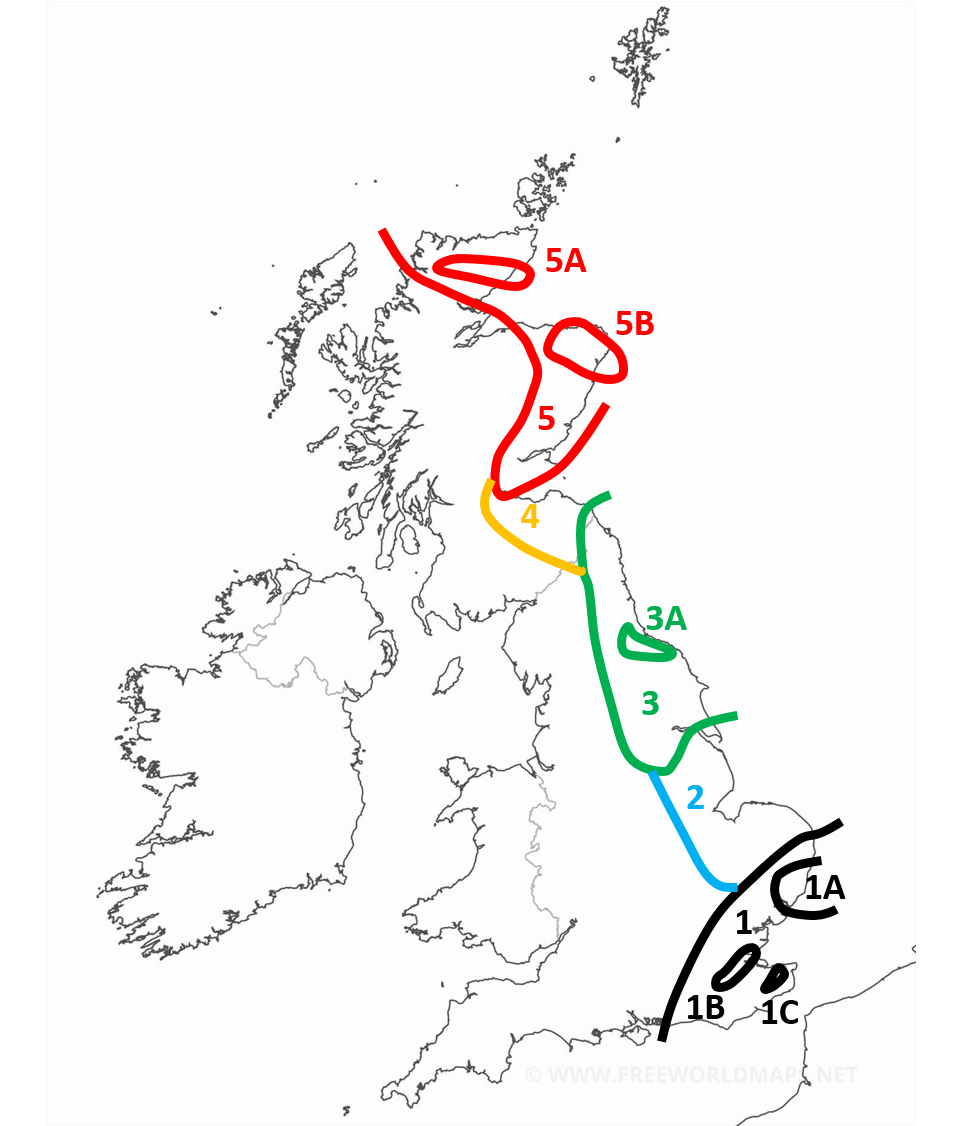


sundaysnowamounts


Region 1: 2-5cm generally with more for the more south eastern parts of the region. Around the border expect less than 2cm. With patchy snow occasionally extending outside of the region.

Region 1A: More than 3cm with locally as much as 7cm

Region 1B: In the early afternoon the snow is expected to start banding with some convective activity enhancing the front. Locally as high as 15cm

Region 1C: Similar to 1B, enhanced snow activity expected here. With 5-10cm expected.

Region 2: Occasional snow showers but negligable amounts. During the late afternoon and evening heavy snow showers are expected particularly in the NE of the region giving 2-5cm locally. Some of the snow showers are likely to band and form streamers, though this is more of a hazard for early monday.

Region 3: Snow showers most of the day, especially mid morning onwards. Mostly light or moderate but occasionally heavy. Highly variable snow amounts. 1-5cm generally.

Region 3A: Showers expected to be concentrated and heavier around this region. 3-7cm.

Region 4: Light or moderate scattered snow showers. Smaller amounts expected here. 1-3cm

Region 5: Heavy but often scattered snow showers. Amounts highly variable. 1-10cm, higher amounts expected on higher ground and in the north of the region.

Region 5A: More frequent showers expected here. 3-10cm.

Region 5B: More frequent and sometimes heavier snow showers here. Also possibility of a streamer. 5-10cm.


ADENDUM 1 (1:23pm) : I think the western extent of region 4 and region 3 in particular are a little bit too far east. Snow showers are expected to get as far west as Bradford. In region 4 some snow showers will get as far west as Glasgow.


25/26 (850hpa temp) 11 days snow/sleet falling

18/11 (-4) 19/11 (-6) 20/11 (-6) 01/01 (-7) 04/01 (-10) 10/01 (-7) 11/01 (-3) 30/01 (-1) 13/02 (-6) 15/02 (-4) 18/02 (-6)

24/25 10d

18/11 (-6) 19/11 (-6) 23/11 (-2) 22/12 (-5) 04/01 (-5) 05/01 (0)14/02 (0) 15/02 (0)12/03 (-6) 13/03 (-6)

23/24 8d

29/11 (-6) 30/11 (-6) 02/12 (-5) 03/12 (-5) 04/12 (-3) 16/01 (-3) 18/01 (-8)08/02 (-5)

22/23 7d

18/12 (-1)06/03 (-6) 08/03 (-8) 09/03 (-6) 10/03 (-8) 11/03 (-5) 14/03 (-6)

21/22 12d

Gooner
06 February 2021 13:14:53

I know people like my snow MS paint maps so here are my thoughts for tommorow.

https://i.ibb.co/tMMrKTn/sundaysnowamounts.png 


sundaysnowamounts


Region 1: 2-5cm generally with more for the more south eastern parts of the region. Around the border expect less than 2cm. With patchy snow occasionally extending outside of the region.

Region 1A: More than 3cm with locally as much as 7cm

Region 1B: In the early afternoon the snow is expected to start banding with some convective activity enhancing the front. Locally as high as 15cm

Region 1C: Similar to 1B, enhanced snow activity expected here. With 5-10cm expected.

Region 2: Occasional snow showers but negligable amounts. During the late afternoon and evening heavy snow showers are expected particularly in the NE of the region giving 2-5cm locally. Some of the snow showers are likely to band and form streamers, though this is more of a hazard for early monday.

Region 3: Snow showers most of the day, especially mid morning onwards. Mostly light or moderate but occasionally heavy. Highly variable snow amounts. 1-5cm generally.

Region 3A: Showers expected to be concentrated and heavier around this region. 3-7cm.

Region 4: Light or moderate scattered snow showers. Smaller amounts expected here. 1-3cm

Region 5: Heavy but often scattered snow showers. Amounts highly variable. 1-10cm, higher amounts expected on higher ground and in the north of the region.

Region 5A: More frequent showers expected here. 3-10cm.

Region 5B: More frequent and sometimes heavier snow showers here. Also possibility of a streamer. 5-10cm.


Originally Posted by: Quantum 

What the hell are you on about they are crap 


All JFF Q but I do feel you are being harsh to the rest of the UK you have ignored 


Remember anything after T120 is really Just For Fun


Marcus

Banbury

North Oxfordshire

378 feet A S L


Whether Idle
06 February 2021 13:17:44

I know people like my snow MS paint maps so here are my thoughts for tommorow.

https://i.ibb.co/tMMrKTn/sundaysnowamounts.png 


Region 1: 2-5cm generally with more for the more south eastern parts of the region. Around the border expect less than 2cm. With patchy snow occasionally extending outside of the region.

Region 1A: More than 3cm with locally as much as 7cm

Region 1B: In the early afternoon the snow is expected to start banding with some convective activity enhancing the front. Locally as high as 15cm

Region 1C: Similar to 1B, enhanced snow activity expected here. With 5-10cm expected.

Region 2: Occasional snow showers but negligable amounts. During the late afternoon and evening heavy snow showers are expected particularly in the NE of the region giving 2-5cm locally. Some of the snow showers are likely to band and form streamers, though this is more of a hazard for early monday.

Region 3: Snow showers most of the day, especially mid morning onwards. Mostly light or moderate but occasionally heavy. Highly variable snow amounts. 1-5cm generally.

Region 3A: Showers expected to be concentrated and heavier around this region. 3-7cm.

Region 4: Light or moderate scattered snow showers. Smaller amounts expected here. 1-3cm

Region 5: Heavy but often scattered snow showers. Amounts highly variable. 1-10cm, higher amounts expected on higher ground and in the north of the region.

Region 5A: More frequent showers expected here. 3-10cm.

Region 5B: More frequent and sometimes heavier snow showers here. Also possibility of a streamer. 5-10cm.


Originally Posted by: Quantum 

This will be worth checking for veracity afterwards.


Dover, 5m asl. Half a mile from the south coast.
Quantum
  • Quantum
  • Advanced Member Topic Starter
06 February 2021 13:21:46


What the hell are you on about they are crap 


All JFF Q but I do feel you are being harsh to the rest of the UK you have ignored 

Originally Posted by: Gooner 

Snow showers will extend further west outside these regions. But typically smaller amounts. Took quite a few hours to do that map, so I focused on where the majority of the action is going to be.


25/26 (850hpa temp) 11 days snow/sleet falling

18/11 (-4) 19/11 (-6) 20/11 (-6) 01/01 (-7) 04/01 (-10) 10/01 (-7) 11/01 (-3) 30/01 (-1) 13/02 (-6) 15/02 (-4) 18/02 (-6)

24/25 10d

18/11 (-6) 19/11 (-6) 23/11 (-2) 22/12 (-5) 04/01 (-5) 05/01 (0)14/02 (0) 15/02 (0)12/03 (-6) 13/03 (-6)

23/24 8d

29/11 (-6) 30/11 (-6) 02/12 (-5) 03/12 (-5) 04/12 (-3) 16/01 (-3) 18/01 (-8)08/02 (-5)

22/23 7d

18/12 (-1)06/03 (-6) 08/03 (-8) 09/03 (-6) 10/03 (-8) 11/03 (-5) 14/03 (-6)

21/22 12d

NMA
  • NMA
  • Advanced Member
06 February 2021 13:23:55

I know people like my snow MS paint maps so here are my thoughts for tommorow.

https://i.ibb.co/tMMrKTn/sundaysnowamounts.png 


sundaysnowamounts


Region 1: 2-5cm generally with more for the more south eastern parts of the region. Around the border expect less than 2cm. With patchy snow occasionally extending outside of the region.

Region 1A: More than 3cm with locally as much as 7cm

Region 1B: In the early afternoon the snow is expected to start banding with some convective activity enhancing the front. Locally as high as 15cm

Region 1C: Similar to 1B, enhanced snow activity expected here. With 5-10cm expected.

Region 2: Occasional snow showers but negligable amounts. During the late afternoon and evening heavy snow showers are expected particularly in the NE of the region giving 2-5cm locally. Some of the snow showers are likely to band and form streamers, though this is more of a hazard for early monday.

Region 3: Snow showers most of the day, especially mid morning onwards. Mostly light or moderate but occasionally heavy. Highly variable snow amounts. 1-5cm generally.

Region 3A: Showers expected to be concentrated and heavier around this region. 3-7cm.

Region 4: Light or moderate scattered snow showers. Smaller amounts expected here. 1-3cm

Region 5: Heavy but often scattered snow showers. Amounts highly variable. 1-10cm, higher amounts expected on higher ground and in the north of the region.

Region 5A: More frequent showers expected here. 3-10cm.

Region 5B: More frequent and sometimes heavier snow showers here. Also possibility of a streamer. 5-10cm. 

Originally Posted by: Quantum 

Great stuff Q. Have you entered Saints snow depth forecast for your location?


Vale of the Great Dairies

South Dorset

Elevation 60m 197ft

Gooner
06 February 2021 13:26:19


Snow showers will extend further west outside these regions. But typically smaller amounts. Took quite a few hours to do that map, so I focused on where the majority of the action is going to be.

Originally Posted by: Quantum 

We know when we aren't important 


Remember anything after T120 is really Just For Fun


Marcus

Banbury

North Oxfordshire

378 feet A S L


Quantum
  • Quantum
  • Advanced Member Topic Starter
06 February 2021 13:26:31

May post an update to the map this evening with the 12Z data.

I think the catogaries will be largelly the same, just some of the boundaries tweaked.


25/26 (850hpa temp) 11 days snow/sleet falling

18/11 (-4) 19/11 (-6) 20/11 (-6) 01/01 (-7) 04/01 (-10) 10/01 (-7) 11/01 (-3) 30/01 (-1) 13/02 (-6) 15/02 (-4) 18/02 (-6)

24/25 10d

18/11 (-6) 19/11 (-6) 23/11 (-2) 22/12 (-5) 04/01 (-5) 05/01 (0)14/02 (0) 15/02 (0)12/03 (-6) 13/03 (-6)

23/24 8d

29/11 (-6) 30/11 (-6) 02/12 (-5) 03/12 (-5) 04/12 (-3) 16/01 (-3) 18/01 (-8)08/02 (-5)

22/23 7d

18/12 (-1)06/03 (-6) 08/03 (-8) 09/03 (-6) 10/03 (-8) 11/03 (-5) 14/03 (-6)

21/22 12d

Justin W
06 February 2021 13:28:37

I know people like my snow MS paint maps so here are my thoughts for tommorow.

https://i.ibb.co/tMMrKTn/sundaysnowamounts.png 


sundaysnowamounts


Region 1: 2-5cm generally with more for the more south eastern parts of the region. Around the border expect less than 2cm. With patchy snow occasionally extending outside of the region.

Region 1A: More than 3cm with locally as much as 7cm

Region 1B: In the early afternoon the snow is expected to start banding with some convective activity enhancing the front. Locally as high as 15cm

Region 1C: Similar to 1B, enhanced snow activity expected here. With 5-10cm expected.

Region 2: Occasional snow showers but negligable amounts. During the late afternoon and evening heavy snow showers are expected particularly in the NE of the region giving 2-5cm locally. Some of the snow showers are likely to band and form streamers, though this is more of a hazard for early monday.

Region 3: Snow showers most of the day, especially mid morning onwards. Mostly light or moderate but occasionally heavy. Highly variable snow amounts. 1-5cm generally.

Region 3A: Showers expected to be concentrated and heavier around this region. 3-7cm.

Region 4: Light or moderate scattered snow showers. Smaller amounts expected here. 1-3cm

Region 5: Heavy but often scattered snow showers. Amounts highly variable. 1-10cm, higher amounts expected on higher ground and in the north of the region.

Region 5A: More frequent showers expected here. 3-10cm.

Region 5B: More frequent and sometimes heavier snow showers here. Also possibility of a streamer. 5-10cm.


ADENDUM 1 (1:23pm) : I think the western extent of region 4 and region 3 in particular are a little bit too far east. Snow showers are expected to get as far west as Bradford. In region 4 some snow showers will get as far west as Glasgow.


Originally Posted by: Quantum 

You’ve undercooked Region 1c I think. IMO we will get 20-30cm


Yo yo yo. 148-3 to the 3 to the 6 to the 9, representing the ABQ, what up, biatch?
Joe Bloggs
06 February 2021 13:32:01


Snow showers will extend further west outside these regions. But typically smaller amounts. Took quite a few hours to do that map, so I focused on where the majority of the action is going to be.

Originally Posted by: Quantum 

Good map for tomorrow, very good effort indeed. 

Towards Monday and Tuesday I think more central parts could be affected, e.g. places like Sheffield, Peak District etc. 


Remove ads from site