The Weather Outlook

Remove ads from site

Downpour
12 December 2022 13:51:27

what % has been bone dry ? Keep peddling the line and you will end up believing it. From 90% to majority

Originally Posted by: ballamar 

It's a fair question – most/all of London has had snow so that kills the 90% call in and of itself.

I'd guess that 60-70% of the UK population is snowless however. 

The midweek snow could however turn that majority into a minority...


Chingford

London E4

147ft

Taylor1740
12 December 2022 13:57:26
I can confirm it has been bone dry here which is disappointing considering how long the cold spell has been. We might get some transient snow Sunday as the mild South Westerlies push in but I'm not really going to get excited about any snow that's going to immediately melt/ turn to rain.
NW Leeds - 150m amsl
John p
12 December 2022 14:00:14

Been very bone dry here with little snow due to fog killing them off.  Seeing the earlier posters posting nice perb charts look nice because it would bring nationwide snowfall so to be very fair for everyone to get in, plus not bone dry type as it will be windy so nasty fog cannot form to block the snow like this spell did.  

Originally Posted by: Jiries 

Fog doesn’t kill off snowfall. What it means is you don’t have any frontal systems bringing snow over you. It doesn’t repel the fronts!


Camberley, Surrey
Bolty
12 December 2022 14:06:09
Interesting Christmas scenario on the 6Z GFS. It's very much a Christmas 2004 setup, which was the last truly "white Christmas" around here (snow both falling and lying). Most northern and western coasts would be prone to wintry showers in such a situation:

Not to be taken seriously in any way of course, but just interesting to point out.

UserPostedImageUserPostedImage


Scott

Blackrod, Lancashire (4 miles south of Chorley) at 156m asl.

My weather station 

Rob K
12 December 2022 14:15:43

what % has been bone dry ? Keep peddling the line and you will end up believing it. From 90% to majority

Originally Posted by: ballamar 

A good chunk of the south has had snow, from Devon (and Cornwall?) right over to Essex. Admittedly here in Hampshire we fell in the gap a bit but we still have full cover on the lawn, albeit only half a cm.


Yateley, NE Hampshire, 73m asl

"But who wants to be foretold the weather? It is bad enough when it comes, without our having the misery of knowing about it beforehand." — Jerome K. Jerome

nsrobins
12 December 2022 15:08:31
On behalf of the SW contingent I’m keeping an eye on Tues night. Although GFS dropped the ppn into SW and S and UKV has trended away, ICON 12Z looks like a more robust push again of the frontal boundary.

Touch and go but a finite chance.


Neil

Fareham, Hampshire 28m ASL (near estuary)

Stormchaser, Member TORRO

squish
12 December 2022 15:12:12
ICON 12z looking promising as we head to the pivotal point around +108/120
D.E.W on Dartmoor. 300m asl
Brian Gaze
12 December 2022 15:17:27
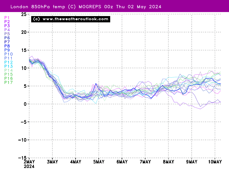
MOGREPS 06z was disappointing if it's cold you're after.

UserPostedImage


Brian Gaze

Berkhamsted

TWO Buzz - get the latest news and views 

"I'm not socialist, I know that. I don't believe in sharing my money." - Gary Numan

Heavy Weather 2013
12 December 2022 15:20:55

MOGREPS 06z was disappointing if it's cold you're after.

UserPostedImage

Originally Posted by: Brian Gaze 

I am comfortable with that, many on the turn after the 20th. 18th -21st seems to be the mild windows. The core period and building blocks are what we need to focus on atm, to see if we can build towards something colder towards Christmas. 


Mark

Beckton, E London

Less than 500m from the end of London City Airport runway.

MRayner
12 December 2022 15:25:20

MOGREPS 06z was disappointing if it's cold you're after.

Well, after not getting above -8C today , with a possibility of much colder tonight, and below freezing all week ,i will be quite happy to see the MOGREPS Being correct !!
UserPostedImage

Originally Posted by: Brian Gaze 


Location Whisky 🥃 country, Cragganmore ,Moray, 440 AMSL

Whiteout
12 December 2022 15:35:30

On behalf of the SW contingent I’m keeping an eye on Tues night. Although GFS dropped the ppn into SW and S and UKV has trended away, ICON 12Z looks like a more robust push again of the frontal boundary.

Touch and go but a finite chance.


Originally Posted by: nsrobins 

Yes, as UKV drops the bone ICON picks it up lol, going to be a case of wait and see I think.


Home/Work - Dartmoor

240m/785 ft asl

Gandalf The White
12 December 2022 15:58:00

I am comfortable with that, many on the turn after the 20th. 18th -21st seems to be the mild windows. The core period and building blocks are what we need to focus on atm, to see if we can build towards something colder towards Christmas. 

Originally Posted by: Heavy Weather 2013 

Yes, it's fascinating to see how the models have all firmed up on the pattern change on Sunday are are now searching for what follows; there aren't any strong signs at the moment of the changed pattern lasting long.

It makes a change to be looking at potential options for renewed cold as we run into the Xmas period whilst there's about 10cm of snow lying on the ground outside my window.


Location: South Cambridgeshire

130 metres ASL

52.0N 0.1E


squish
12 December 2022 16:12:32
Another eye opener from UKMO!
D.E.W on Dartmoor. 300m asl
fairweather
12 December 2022 16:16:29
I've not written this week off yet for more snow. Looking at the 12z op the flow becomes Northerly with a kink towards an easterly come Wed into Thursday. I wouldn't rule out an increase in shower activity and a possible Thames streamer.
S.Essex, 42m ASL
squish
12 December 2022 16:23:24
GEM also interesting .  If we weren’t in a cold spell already these would be enticing charts 
D.E.W on Dartmoor. 300m asl
Zubzero
12 December 2022 16:34:37

Fog doesn’t kill off snowfall. What it means is you don’t have any frontal systems bringing snow over you. It doesn’t repel the fronts!

Originally Posted by: John p 

Indeed I had freezing fog all afternoon yesterday, it lifted in the early evening and 10-15 minutes later it started snowing. If anything the fog helped keep the lower air colder ahead of the occlusion moving in. 

Russwirral
12 December 2022 16:48:25
Definitely something brewing in the charts
Joe Bloggs
12 December 2022 16:50:26

Definitely something brewing in the charts

Originally Posted by: Russwirral 

those heights over Europe really are a pain in the arse though. 


Jiries
12 December 2022 16:51:13

Indeed I had freezing fog all afternoon yesterday, it lifted in the early evening and 10-15 minutes later it started snowing. If anything the fog helped keep the lower air colder ahead of the occlusion moving in. 

Originally Posted by: Zubzero 

The less cold fog had completely blocked it in my area as there was a large blob of precips just south of Coventry all day long couldn't get in but once the fog lifted briefly yesterday morning light snow came in and stopped when fog return and block it. 

At least the latest runs will push them away this week so fog no longer around.  The less fog the better is from a northerly or easterly strong winds.

squish
12 December 2022 16:54:19
The 12z control is borderline major snow event for many, and definitely for up north 
D.E.W on Dartmoor. 300m asl
doctormog
12 December 2022 16:54:33

Fog doesn’t kill off snowfall. What it means is you don’t have any frontal systems bringing snow over you. It doesn’t repel the fronts!

Originally Posted by: John p 

Jiries just in case you missed John’s post, see above.

Looking at the models today I would hate to have to be the one to have to make a forecast for next week!


Russwirral
12 December 2022 17:09:23
the 12z GDPS/CMC is not far off probably the closest weve ever been to a snow lovers Nirvana... a stalled front running the bourndary of cold air... somehwere to the north of this would probably have 24hrs PLUS of heavy snow.  A moisture train.

Just like those events where lake district had epc rainfalls in one day... it would be all snow.

Just imagine 😮


Jiries
12 December 2022 17:17:00

Jiries just in case you missed John’s post, see above.

Looking at the models today I would hate to have to be the one to have to make a forecast for next week!

Originally Posted by: doctormog 

I read it but I know what the fog had done yesterday.  Try to forecast next week with the way of the models kept changing a lot, still not reliable as the old days.  You can easily forecast it in the past but not today models poor performance, I remember last week we supposed to be getting an easterly winds here?

moomin75
12 December 2022 17:19:08
Anyone of a nervous disposition, don't look at GEM.Snow fest on Sunday, followed by a brief warm up, then another snow fest 4 days before Christmas. 

​​​​​​​Nice eye candy if nothing else. 


Witney, Oxfordshire

100m ASL

Whiteout
12 December 2022 17:19:48
I think the Met tweet sums up the chances for snow down here tomorrow night:

20% chance of snow in the SW quadrant

Bodmin and Dartmoor 20% chance of between 5cms and 20cms depending on elevation

Sounds about right to me.


Home/Work - Dartmoor

240m/785 ft asl

Remove ads from site