The Weather Outlook

Remove ads from site

TimS
  • TimS
  • Advanced Member Topic Starter
19 June 2017 18:55:09
So, 3 days down and how many more to go? 2 more days of heat, Thursday marginal depending on timing of the cold front, then either big Northerly followed by cool ridging (ECM, GEM) or mini reload followed by dartboard low (GFS).

Either way this will have been our best extended June hot spell since 2006 at least.

Let's hope it's not the last. I'd like to see a recurring hot pattern lock in for summer. We've had enough recurring wet patterns locking in over the last few years.


Brockley, South East London 30m asl
johncs2016
19 June 2017 19:43:40
It is amazing what just 24 hours can do in terms of our weather. Last night, we were baking with temperatures still at around 22C at about this time, and at 20C even as late as 10pm. Tonight however, it is a completely different story. Even during today, it didn't get above 22C and that maximum temperature occured during the latter part of this morning, before we had even got to lunchtime. It hovered at 21C for most of the time after that before dropping to 17C just a wee while ago. Now, the temperature has dropped even further to a much cooler and fresher 14C which as you can from this post, is a massive difference from this time last night and even quite a big drop (of about 3C) from where we were just about half an hour ago.

Although I have never seen any visual signs of it either from the cloud formations as that front has passed over us, or from the cloud formations in each of the air masses on either side of this weather front (although there is a little bit less cloud now and more sunshine than earlier on with a much clearer atmosphere), I can now safely that the cold front which I have been looking out for has now crossed this part of the country, and that the heatwave in this part of the country is now over as a result.

If the forecast models are correct as well, we could also be in for a quite a long wait for any repeat of the sort of weather which we saw over the weekend. Tomorrow is expected to be a nice day here as well, but a lot cooler than of late. Wednesday doesn't even look very good in terms of the weather we are expected to see some rain at some point, which looks set to mark the beginning of a transition to a more unsettled weather pattern which according to the models, looks set to become even more noticable as we go into next week.

because of that, I just hope that this now doesn't end up being it for our summer but given the nature of the weather in this country, it wouldn't surprise me one single bit if that ended up being the case.


The north of Edinburgh, usually always missing out on snow events which occur not just within the rest of Scotland or the UK, but also within the rest of Edinburgh.

picturesareme
19 June 2017 20:19:57
Feels a little cooler tonight then it did at this time yesterday..

Perhaps maybe because today it got much warmer then yesterday??

Gusty
19 June 2017 20:49:15

We did very well here again today with a maximum temperature of 29.7c (hottest day of the year). 

Saturday - Max 24.9 - Min 17.4

Sunday - Max 29.2 - Min  14.9

Monday - Max 29.7- Min 16.8


Steve - Folkestone, Kent

Current conditions from my Davis Vantage Vue

https://www.wunderground.com/dashboard/pws/IFOLKE11 

Join Kent Weather on Facebook.

https://www.facebook.com/stevewall69/ 


picturesareme
19 June 2017 21:03:42

Feels a little cooler tonight then it did at this time yesterday..

Perhaps maybe because today it got much warmer then yesterday??

Originally Posted by: picturesareme 

im going to retract this!! Just taken the dogs for a 20 min walk and it's still roasting.. very humid and mid 20's still. It must just be the garden that 'feels' cooler. 

picturesareme
19 June 2017 21:04:59

We did very well here again today with a maximum temperature of 29.7c (hottest day of the year). 

Saturday - Max 24.9 - Min 17.4

Sunday - Max 29.2 - Min  14.9

Monday - Max 29.7- Min 16.8

Originally Posted by: Gusty 

how have you got Mondays minimum already? 

19 June 2017 21:06:47

Hotspot today was once again Hampton Waterworks with 32.5C (date record for today is 32.8C)

Yesterday Hampton Waterworks reached 32.1C (date record for yesterday is 32.2C).

So we just missed out on a date record on both days.

Date record for the next 2 days is 31.7C. If the Met Office is to be believed then we will just miss out on the date record again on both days. 

However, ARPEGE has other ideas

The ARPEGE model was wrong today in that it had 33C in the Bristol area. It did have 32C at 1500 in the London area so was broadly correct about that. It seems to slightly over play the temperature further west. That said Pershore did reach 31.9C so not far off what the model was showing.

Tomorrow ARPEGE wants a 35C in the west country. Seems most unlikely. But maybe somewhere like Pershore could be the hottest place tomorrow with the cold front pivoting meaning the SE is less favoured tomorrow. So while London may still see 30C perhaps Pershore might get to 32C again and possibly 33C?

Similar story on Wednesday. A degree hotter again so perhaps 33-34C at Pershore? Temperatures more widely above 30C on Wednesday across the south which has been predicted for the past few days - although that is not what TV forecasts are showing.

Thursday's hotspot likely to be somewhere like Gravesend at around 27C

Latest chart for Friday sees the hot air pushing back slightly further NW again with 27-28C quite widely from Hampshire to Lincolnshire. Don't write off the heat just yet.


19 June 2017 21:10:38


how have you got Mondays minimum already? 

Originally Posted by: picturesareme 

Because the minimum is dated on the day that the 09z reading is taken. So the minimum for 19 June is for the period from 09z on 18 June to 09z on 19 June. Whereas the maximum is dated the previous day (i.e. the maximum for 19 June is from 09z 19 June to 09z on 20 June. 

Bertwhistle
19 June 2017 21:11:02


how have you got Mondays minimum already? 

Originally Posted by: picturesareme 

Pictures- the official way to record the minimum is for the lowest temperature preceding the period defined. So- Monday's minimum is registered as the lowest temperature from the start of the recording period on Sunday (eg 10am= 09GMT) to the same time on Monday.

Edit: I see GW posted the same explanation just as I was posting! Sorry for duplication.


Bertie, Itchen Valley.

Retire while you can still press the 'retire now' button.

johncs2016
19 June 2017 21:13:33
After watching the BBC Scotland forecast earlier on tonight, I discovered that although Edinburgh failed to make it three days in a row with temperatures of 25C, that same temperature was recorded in the Scottish Borders which was therefore, the hottest part of Scotland today as a result. That in turn, means that I wouldn't acually have had to travel very far south to find it being just as hot as it was here at the weekend.

That is important to me, because I have a few family members down there (including my parents). Both my Mum and Dad are members of their local bowling club down there and so, I'm sure that they would have been loving all of this hot weather.


The north of Edinburgh, usually always missing out on snow events which occur not just within the rest of Scotland or the UK, but also within the rest of Edinburgh.

Gusty
19 June 2017 21:18:32

Is anyone feeling we could see 34c or 35c on Wednesday in somewhere like west London or CS England ?

The Spanish plume reaches its closest proximity, we would be 5 days in and the breeze will be very light.


Steve - Folkestone, Kent

Current conditions from my Davis Vantage Vue

https://www.wunderground.com/dashboard/pws/IFOLKE11 

Join Kent Weather on Facebook.

https://www.facebook.com/stevewall69/ 


picturesareme
19 June 2017 21:19:09
Still I always think of it like: Sunday nights low as in the low Sunday night into Monday morning... hence the confusion ✌️
Whether Idle
19 June 2017 21:20:28

Is anyone feeling we could see 34c or 35c on Wednesday in somewhere like west London or CS England ?

The Spanish plume reaches its closest proximity, we would be 5 days in and the breeze will be very light.

Originally Posted by: Gusty 

Cheltenham 35c Wednesday.


Dover, 5m asl. Half a mile from the south coast.
picturesareme
19 June 2017 21:22:41

Is anyone feeling we could see 34c or 35c on Wednesday in somewhere like west London or CS England ?

The Spanish plume reaches its closest proximity, we would be 5 days in and the breeze will be very light.

Originally Posted by: Gusty 

also increased cloud cover according to met automated forecast... if winds back N/NE then my region is in with a decent shout yes. 

By my region I define the northern coastal stretch of the Solent.. 

Gusty
19 June 2017 21:22:56


Cheltenham 35c Wednesday.

Originally Posted by: Whether Idle 

Thanks Phil 


Steve - Folkestone, Kent

Current conditions from my Davis Vantage Vue

https://www.wunderground.com/dashboard/pws/IFOLKE11 

Join Kent Weather on Facebook.

https://www.facebook.com/stevewall69/ 


Gusty
19 June 2017 21:25:25

 also increased cloud cover according to met automated forecast... if winds back N/NE then my region is in with a decent shout yes. 

By my region I define the northern coastal stretch of the Solent.. 

Originally Posted by: picturesareme 

It will be an interesting day Picturesareme. Not a million miles from the all time June maximum temperature of 35.6c achieved in Southampton on 28th June 1976. 


Steve - Folkestone, Kent

Current conditions from my Davis Vantage Vue

https://www.wunderground.com/dashboard/pws/IFOLKE11 

Join Kent Weather on Facebook.

https://www.facebook.com/stevewall69/ 


19 June 2017 21:34:51

WRF model has London as the hot spot again tomorrow between 30-31C


http://modeles.meteociel.fr/modeles/wrfnmm/runs/2017061912/nmm_uk1-41-25-1.png?19-18

Same again on Wednesday with 30-31C in London and 30C around the Bristol area

http://modeles.meteociel.fr/modeles/wrfnmm/runs/2017061912/nmm-0-51-1.png?19-19

Much cooler on Thursday compared to ARPEGE

http://modeles.meteociel.fr/modeles/wrfnmm/runs/2017061912/nmm-0-75-1.png?19-19

So quite big differences between the models on temperatures. But ARPEGE does seem to be out on a limb compared to the others which is probably why it is being discounted at the moment in official forecasts. That said it has correctly picked up on a hot spot in the west - albeit it has shown the hot spot a little further south than where it has actually occurred (Pershore).

picturesareme
19 June 2017 21:37:12


It will be an interesting day Picturesareme. Not a million miles from the all time June maximum temperature of 35.6c achieved in Southampton on 28th June 1976. 

Originally Posted by: Gusty 

Indeed gusty :)

Southampton has a couple of date records of similar temps in June too... 😏

Elstevio
19 June 2017 21:41:38
28c Saturday 30.4c Sunday and 30.8c today on my vantage pro 2. Nearby airport matches these within 0.4c. Been sweltering here again. Even the usual cooling easterly has failed to get going.
Aylsham, North Norfolk

johncs2016
19 June 2017 21:52:09
It was very interesting to hear on one of today's BBC Forecasts that for those of you down south who are currently experiencing temperatures of over 30C during the day (the heatwave here in the south of Scotland might be over, but your heatwave is expected to continue until the end of the week), it was actually hotter than some traditionally hot locations such as Miami in Florida which might well be normally considered to be in one of the hottest parts of America, but which hasn't even been getting above 30C recently. I'm sure that is something to savour, and quite amazing when you consider that Britain is geographically nothing more than an island in the eastern part of the Atlantic Ocean, which is therefore completely surrounded by water which is always relatively cold at this time of year (that cold blob in the Atlantic which was there in that really cool summer of 2015 is there this year as well but unlike in 2015, is clearly not having the same effect on our weather as it did then).


The north of Edinburgh, usually always missing out on snow events which occur not just within the rest of Scotland or the UK, but also within the rest of Edinburgh.

TimS
  • TimS
  • Advanced Member Topic Starter
20 June 2017 07:31:37
But cloudy and muggy (and polluted) this morning. We could do with a bit of a breeze. Not much power coming from wind turbines this week.
Brockley, South East London 30m asl
Stormchaser
20 June 2017 09:01:42

This morning has not raced out of the starting blocks like yesterday did, due to a bit of high cloud and even a few cumulus about between 7:30 and 8:30, plus a slight breeze - but this breeze has a northerly component to it which is significant given that the sea breeze will soon be attempting to move the air in the opposite direction.

That should either lead to a 'dead heat' if the dry air and strong capping inversion keep it clear despite the surface convergence, or the sudden development of what could rapidly grow into towering cumulonimbus given the CAPE that will be present.

Models favour the former outcome (for example ARPEGE produced a single afternoon shower near to this location on the 00z run yesterday but has lost interest since then) and as a result ARPEGE produces maximums of 31 or 32*C (below-left) despite the slower start to the day (then again it's only about a degree behind yesterday at this stage);
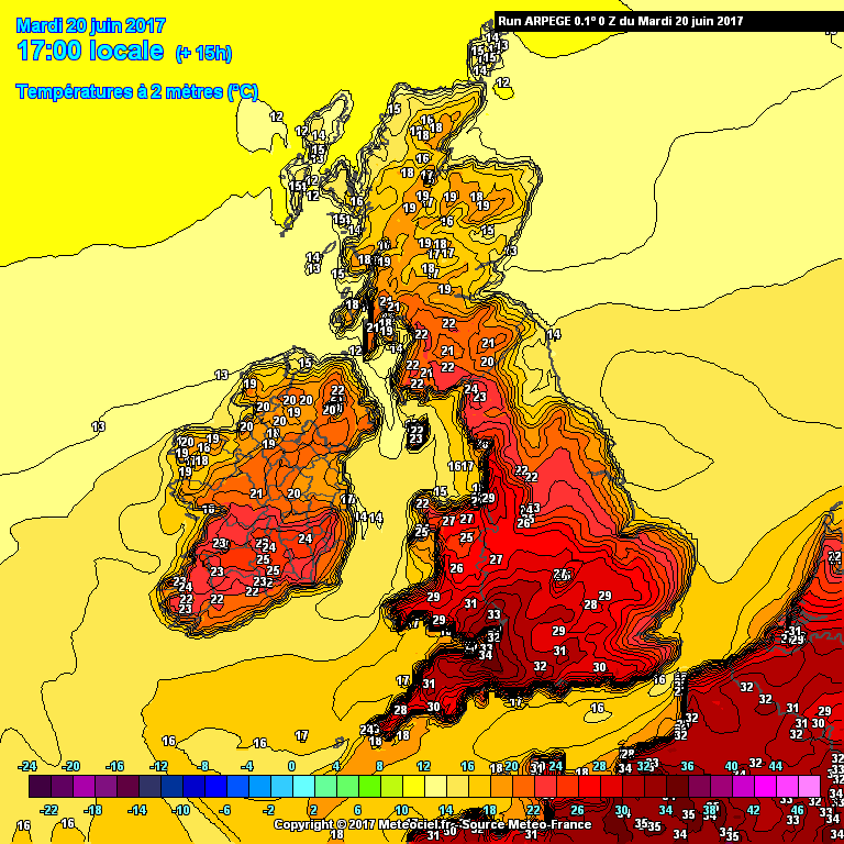
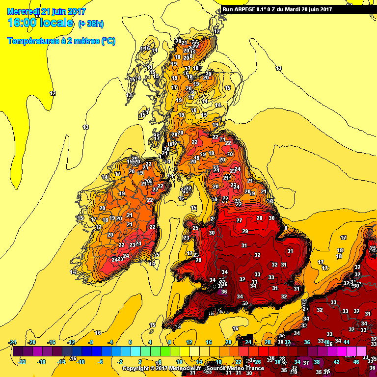
 

It will be very important whether such values actually manifest today, and even more so those values around Bristol, given what ARPEGE continues to predict for tomorrow, although in that case there does look to be some kind of 'wave of heat' moving across from the southwest, clearest to see on the Theta-E charts:


That arm of black shading represents a band of air with the potential to achieve values rarely seen in the UK. Question is whether cloud amounts and sea breeze interactions will really allow that to occur. The timing has shifted from the 12z to be a few hours earlier so now it's during the peak heating hours which is alarming to say the least!

ARPEGE doesn't stop there either; the peak of the plume takes a little longer to clear east than it did on the 12z and as a result East Anglia has a run at the mid-30s on Thursday .

So yeah - how close ARPEGE ends up being today will determine whether we should be truly concerned or in a position to mock the model's antics.


p.s. Why is this called 'hot spell late June' when it's mid-June? 


If you have any problems or queries relating to TWO you can Email [email protected]

https://twitter.com/peacockreports 

2025's Homeland Extremes:

T-Max: 32.0°C 12th Aug | T-Min: -5.4°C 4th Jan | Wettest Day: 31.8 mm 18th Dec | Ice Days: None

Keep Calm and Forecast On

picturesareme
20 June 2017 10:23:33
Storm it was over 24C by 9am down here..

Phil G
20 June 2017 11:01:02
Quite an impressive Cape chart. At such short time frame too.

http://old.wetterzentrale.de/pics/Rtavn3611.gif 

picturesareme
20 June 2017 11:11:17
Likely to hit 30C very very soon...

29.8C at moment ☀

Feels very very warm (borderline hot) with the humidity.

Remove ads from site