The Weather Outlook

Remove ads from site

David M Porter
29 December 2025 10:18:25

Ecm is the best Op and best ensembles this morning,  historic freeze up if its on the money. 

https://www.wetterzentrale.de/en/show_diagrams.php?geoid=50893&model=ecm&var=2&run=0&lid=ENS&bw=1 

Originally Posted by: Ally Pally Snowman 

To quote Popeye, "Blows me down!"

That is some run indeed, and we haven't seen a great deal of those in the model output in all the winters we have had since 2010. 

Very interesting times for sure.


Lenzie, Glasgow

"A body of men holding themselves accountable to nobody ought not to be trusted by anybody." – Thomas Paine

The Beast from the East
29 December 2025 10:30:00
High risk high reward as they say. I would bank the GFS 06z for the south.  We stay on the cold side of the jet and slider low should deliver plenty of snow. (apart from Isle of Sheppey - LOL)


Purley, Surrey, 70m ASL

"We have some alternative facts for you"

Kelly-Ann Conway - former special adviser to the President

Ally Pally Snowman
29 December 2025 10:34:53
Hippydave
29 December 2025 10:43:12

High risk high reward as they say. I would bank the GFS 06z for the south.  We stay on the cold side of the jet and slider low should deliver plenty of snow. (apart from Isle of Sheppey - LOL)

Originally Posted by: The Beast from the East 

Yeah it's a paint by numbers run for how to get snow from a northerly:-

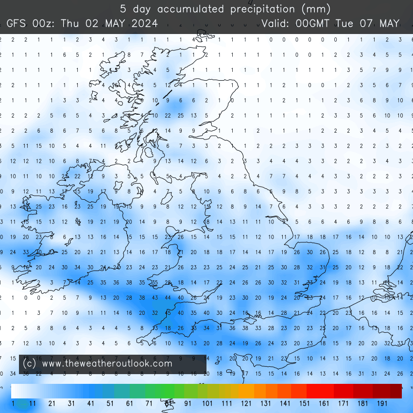
1) Convection for prone areas, i.e Scotland and windward coasts on both sides of the UK. (Only to 03/01 as it's accumulated but gives the gist).

UserPostedImage

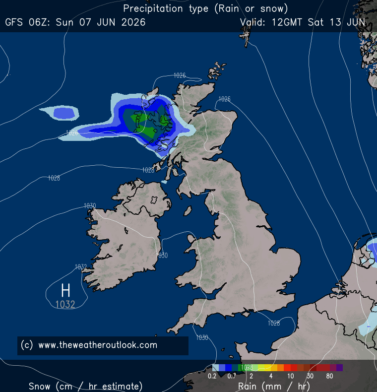
2) Features developing in the flow, giving more organised precip to certain areas - on the chart below a small disturbance hits NE Scotland:-

UserPostedImage

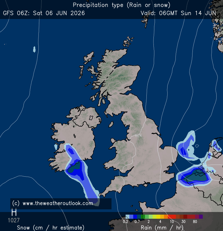
3) LPs bumping into the cold air, hopefully in a way that doesn't bring mild air in afterwards, 6z GFS nails this:-

UserPostedImage

The encroaching LP and small features stuff is clearly not to be taken too seriously at this range but the convective stuff seems highly likely I'd imagine and at least I can look at Scottish web and traffic cams to get a vicarious snow fix if needs be😂

Not shown at present happily but experience suggests when you're looking at LP incursions you need to roll a few sixes in a row to get something like the above chart for the far south and you often see the first low end up in France then the second low approaches on a more NE trajectory and snow is restricted to areas further north (or variations of the law of sod that make it cold rain IMBY).

Still bit daft getting too hung up on that sort of detail at the moment, given the range and uncertainties and not surprisingly the 6z op strongly suggests something interesting this way comes! 


Home: Tunbridge Wells

Work: Tonbridge

doctormog
29 December 2025 10:43:44
Some of the models (including the GFS 06z op) are showing incredibly cold conditions for parts of N Scotland in the coming ten days or so. Given the cold that is already established in parts of the Highlands since Christmas that could cause a few issues (and lots of frozen lochs!)

The GFS 06z and ECM 00z runs also show the possibility of more widespread snow than would normally be associated with a “typical” northerly. Interesting times.


Sasa
  • Sasa
  • Advanced Member
29 December 2025 10:52:46

Nice channel low on the GFS 6z. 

https://www.wetterzentrale.de/en/topkarten.php?map=20&model=gfs&var=1&run=6&time=192&lid=OP&h=0&mv=0&tr=3#mapref 

Originally Posted by: Ally Pally Snowman 

I am still not convinced this is  a classic Channel low snow event for London, but it does show snow potential nudging closer, mainly via wrap-around / secondary features, not a clean frontal undercut.

So: improving, but still not the “gold standard” SE snow setup. I reckon that would produce sleet or snow perhaps in certain spots with only sporadic accumulation resulting from Atlantic system bumping into cold  as opposed to sliding underneath it.


Kingston Upon Thames
Hippydave
29 December 2025 11:28:46

Some of the models (including the GFS 06z op) are showing incredibly cold conditions for parts of N Scotland in the coming ten days or so. Given the cold that is already established in parts of the Highlands since Christmas that could cause a few issues (and lots of frozen lochs!)

The GFS 06z and ECM 00z runs also show the possibility of more widespread snow than would normally be associated with a “typical” northerly. Interesting times.

Originally Posted by: doctormog 

Assuming something not too far from what some of the output shows verifies it looks perfectly setup for some notable minimums and maximums - would assume some of the highlands etc. would be looking at daytime maxes well below freezing. ECM Op has some -8 and -9c maxes shown, which would I guess be even lower in some prone spots.

Could be a very cold couple of weeks for your neck of the woods in particular and *if* the more widespread snowfalls modelled occur, some unusually low minimums for parts of England at times too. (On the 6z op and ECM op the cold doesn't leave parts of Scotland for essentially the whole run, probably not great for heating bills, travelling etc. but I imagine the ski industry would enjoy it!).

Give it another few days and it'll probably be time to start a low temp watch thread. Who'd have thought that after the start to December😁


Home: Tunbridge Wells

Work: Tonbridge

Ally Pally Snowman
29 December 2025 11:40:52
The AIFS 6z holds onto the cold air longer than the 0z.  11th to be exact.
Bishop's Stortford 85m ASL.
moomin75
29 December 2025 11:48:00

The AIFS 6z holds onto the cold air longer than the 0z.  11th to be exact.

Originally Posted by: Ally Pally Snowman 

Yep, looks OK. But the 6z GEFS Ensembles provides a sobering moment to suggest that it may not last long, with a number of runs bringing the Atlantic back quickly. They could all be wrong of course, and given ECM and UKMO look so good, definitely no need to worry just yet.


Witney, Oxfordshire

100m ASL

llamedos
29 December 2025 11:51:43

Some of the models (including the GFS 06z op) are showing incredibly cold conditions for parts of N Scotland in the coming ten days or so. Given the cold that is already established in parts of the Highlands since Christmas that could cause a few issues (and lots of frozen lochs!)

The GFS 06z and ECM 00z runs also show the possibility of more widespread snow than would normally be associated with a “typical” northerly. Interesting times.

Originally Posted by: doctormog 

 Do you know Michael I've never considered that - I assume that's around the shore lines rather than the whole lock ?


"Life with the Lions"

TWO Moderator

Brian Gaze
29 December 2025 11:56:25
GEFS 06Z t+246 mean is actually a tad colder than the 00Z t+240. That said, it could be a statistical anomaly more than anything else - perhaps due to a few significantly colder runs skewing the mean.

 UserPostedImage


Brian Gaze

Berkhamsted

TWO Buzz - get the latest news and views 

"I'm not socialist, I know that. I don't believe in sharing my money." - Gary Numan

doctormog
29 December 2025 11:56:32

Do you know Michael I've never considered that - I assume that's around the shore lines rather than the whole lock ?

Originally Posted by: llamedos 

I think it would depend on the loch but many I believe would freeze across completely given the current conditions and the forecast weather. Loch Morlich is well on the way already as the webcam  shows.

As for the GEFS ensemble data, they are very similar to the previous set and paint a cold picture.


Brian Gaze
29 December 2025 12:01:14
Interesting to see a couple of mild outliers on the 06Z update.

UserPostedImage


Brian Gaze

Berkhamsted

TWO Buzz - get the latest news and views 

"I'm not socialist, I know that. I don't believe in sharing my money." - Gary Numan

moomin75
29 December 2025 12:05:03

Interesting to see a couple of mild outliers on the 06Z update.

UserPostedImage

Originally Posted by: Brian Gaze 

Thankfully (I hope just a couple of rogue stragglers there). The mean is still really good.


Witney, Oxfordshire

100m ASL

Hippydave
29 December 2025 12:11:01

Interesting to see a couple of mild outliers on the 06Z update.

UserPostedImage

Originally Posted by: Brian Gaze 

00z set had something similar and I think yesterday's runs did too although could be remembering that wrong:-

UserPostedImage

They all go back cold again - without looking at the setup I guess they have a quicker LP incursion before colder air returns. 


Home: Tunbridge Wells

Work: Tonbridge

Sasa
  • Sasa
  • Advanced Member
29 December 2025 12:11:37
Not a red flag yet.

They only really become a concern if more members start joining them on successive runs, and/or if the ensemble mean itself begins to lift, rather than it just being increased spread.

The milder outliers seem to coincide with a period where some members show precipitation spikes. That’s consistent with the “milder” solutions being linked to a more engaged Atlantic low scenario, rather than a wholesale breakdown of the cold pattern.


Kingston Upon Thames
Ally Pally Snowman
29 December 2025 12:16:50

Interesting to see a couple of mild outliers on the 06Z update.

UserPostedImage

Originally Posted by: Brian Gaze 

Potential snow bringers?


Bishop's Stortford 85m ASL.
tallyho_83
29 December 2025 13:23:13

GFS still keen to split the block and sink. I suppose not worth looking beyond 144 in these situations. 

I dont like northerlies for the reasons we can see.  Looks mostly dry for the south.  

Originally Posted by: The Beast from the East 

I notice that - that channel feature next weekend 3rd/4th etc looks like going way to the south and S. UK looks bone dry. It will be a disaster of a cold spell if we don't get any snow or frost.


Home Location - Vixen Tor Close, Okehampton, Devon (221m ASL)

---------------------------------------

Sean Moon

Magical Moon

www.magical-moon.com

Gandalf The White
29 December 2025 13:27:11

Potential snow bringers?

Originally Posted by: Ally Pally Snowman 

That’s Perts 8 and 17 and both push the warm front further north.  8 delivers a day of heavy rain for the SE with snow as it clears east, but buckets of snow further north and west.  17 is broadly similar but the push of mild air gets into the Midlands before retreating.


Location: South Cambridgeshire

130 metres ASL

52.0N 0.1E


doctormog
29 December 2025 13:28:06

I notice that - that channel feature next weekend 3rd/4th etc looks like going way to the south and S. UK looks bone dry. It will be a disaster of a cold spell if we don't get any snow or frost.

Originally Posted by: tallyho_83 

I suspect if the UK looked “bone dry” on the model output the Met Office probably wouldn’t have issued a weather warning starting from Thursday? (With the suggestion of more to come).


scillydave
29 December 2025 13:38:39

I notice that - that channel feature next weekend 3rd/4th etc looks like going way to the south and S. UK looks bone dry. It will be a disaster of a cold spell if we don't get any snow or frost.

Originally Posted by: tallyho_83 

I very much doubt that frost will be in short supply given the current output.

As for snow as ever with a northerly those central and south in the UK need a little feature running down through the flow or a southerly tracking low pressure to deliver the goods.

Uk wide snow is a fantastically rare beast, especially these days, but regardless of whether we see that I think this spell could be particularly good for the Northern contingent. Very 1995 IMHO.


Currently living at roughly 65m asl North of Cowbridge in the Vale of Glamorgan.

Formerly of, Birdlip, highest village in the Cotswolds and snow heaven in winter; Hawkinge in Kent - roof of the South downs and Isles of Scilly, paradise in the UK.

picturesareme
29 December 2025 13:39:59

I suspect if the UK looked “bone dry” on the model output the Met Office probably wouldn’t have issued a weather warning starting from Thursday? (With the suggestion of more to come).

Originally Posted by: doctormog 

He's said south UK - Scotland might as well be Norway when it comes to snow when comparing to some parts of the south.

doctormog
29 December 2025 13:47:41

He's said south UK - Scotland might as well be Norway when it comes to snow when comparing to some parts of the south.

Originally Posted by: picturesareme 

All I saw was UK looks bone dry but I see when reading it he says “S. UK” which at a quick glance is where the confusion lies (as the full stop indicated an abbreviation of “south” rather than a new sentence).

Either way I wouldn’t put too much faith in precipitation charts from one isolated operational run from one model when the general synoptics show an unsettled nature overall in the upcoming period. I also wouldn’t try to down any specifics just yet.


Taylor1740
29 December 2025 14:24:18

Interesting to see a couple of mild outliers on the 06Z update.

UserPostedImage

Originally Posted by: Brian Gaze 

Yes and I think the mean 850s don't look quite as cold as before, this could be the start of the downgrades.

Met office app for my location shows max temps of 3c and mins of -3c for the end of this week which isn't that impressive, would hope for some ice days and sub -5 minimums out of this.


NW Leeds - 150m amsl
Tim A
29 December 2025 14:34:01
The ground temps will be quite affected by whether there is snow cover or not.   Could end up being quite dry in the middle of the country, so we will need some disturbances , if they bring slightly milder upper temps, happy for a bit of marginality to increase the chances of show. 

Proper NE winds bringing showers  well inland are very rare in these situations but models always seem to show these solutions before adjusting to a more North to South flow nearer the time. 


Tim

NW Leeds

187m asl

 My PWS 

Remove ads from site