The Weather Outlook

Remove ads from site

Brian Gaze
30 June 2025 19:49:33

GEFS looks increasingly warm and dry again. Let's see if the trend is maintained tomorrow.

UserPostedImage


Brian Gaze

Berkhamsted

TWO Buzz - get the latest news and views 

"I'm not socialist, I know that. I don't believe in sharing my money." - Gary Numan

TimS
  • TimS
  • Advanced Member
30 June 2025 20:40:56

Yes it would be nice to have some average British Summer weather . Cannot see the attraction in scorching sun and dried up grass and heat induced irratability.

Originally Posted by: bledur 

I was always a lover of hot dry weather, dried up grass and all things generally Mediterranean. The hotter and drier the better. 

Then I started to enter middle age and fresher more average weather started to gain in attractiveness. 

Then I planted a vineyard in Kent and I’m back squarely in team hot and dry. Such is the state and the expectations of English viticulture now that an average May to October would spell disaster. And we’re towards the end of flowering when cool and wet can ruin fruit set. So at least a week more warm sunshine please. 


Brockley, South East London 30m asl
Chunky Pea
30 June 2025 20:55:21

Ecm 12z turns very settled ,significant heatwave by the end.  

Originally Posted by: Ally Pally Snowman 

En 850hPa temp pattern at day 10. I usually find these charts give a better indication of where the primary high and low pressure cells are likely to be positioned that far out than the stock MSLP mean maps. A more average W/NW flow seems to be favoured, which is still going to be very warm regardless given the time of year. 

UserPostedImage


Patrick,

East Galway, Ireland.

fairweather
30 June 2025 21:28:04

I don't really see any improvement in the quality of forecasts short or long term in recent decades to be honest. The weather is, well, unpredictable and still fools every computer. Three days ago were flash floods in the S.E. Yesterday was we are in for a long unsettled cooler spell. Just watched tonight's Met Office video and it is showing virtually no rain Wednesday now, High pressure all the way and cooler fresher temperatures of 25-26C !!. Frankly the Met Office presenters can't possibly be meteorologists any more else they would have had to mention  the lack of rainfall in the south east in the last three months. Pathetic really.


S.Essex, 42m ASL
Downpour
30 June 2025 21:35:03

I don't really see any improvement in the quality of forecasts short or long term in recent decades to be honest. The weather is, well, unpredictable and still fools every computer. Three days ago were flash floods in the S.E. Yesterday was we are in for a long unsettled cooler spell. Just watched tonight's Met Office video and it is showing virtually no rain Wednesday now, High pressure all the way and cooler fresher temperatures of 25-26C !!. Frankly the Met Office presenters can't possibly be meteorologists any more else they would have had to mention  the lack of rainfall in the south east in the last three months. Pathetic really.

Originally Posted by: fairweather 

They seem to avoid talking about the SE most of the time - despite it being the most populous region of the UK by far. The drought here is remarkable, yet barely mentioned. You can count on the fingers on one hand the amount of of meaningful spells of rain we have had since March. An extraordinary dry spell and as you note, no end in sight. 


Chingford

London E4

147ft

The Beast from the East
01 July 2025 01:17:49
Pub run control insane heat for weekend after next.

Seems like a take of two contrasting weekends.  


Purley, Surrey, 70m ASL

"We have some alternative facts for you"

Kelly-Ann Conway - former special adviser to the President

Retron
01 July 2025 03:40:43

I don't really see any improvement in the quality of forecasts short or long term in recent decades to be honest. The weather is, well, unpredictable and still fools every computer. Three days ago were flash floods in the S.E. Yesterday was we are in for a long unsettled cooler spell. Just watched tonight's Met Office video and it is showing virtually no rain Wednesday now, High pressure all the way and cooler fresher temperatures of 25-26C !!. Frankly the Met Office presenters can't possibly be meteorologists any more else they would have had to mention  the lack of rainfall in the south east in the last three months. Pathetic really.

Originally Posted by: fairweather 

It's an interesting one, as time and again even the MetO text forecast - the gold standard - ignores their own automated output. For example, we have this forecast for Leysdown today:

https://ukwct.org.uk/weather/leys.jpg 

UserPostedImage

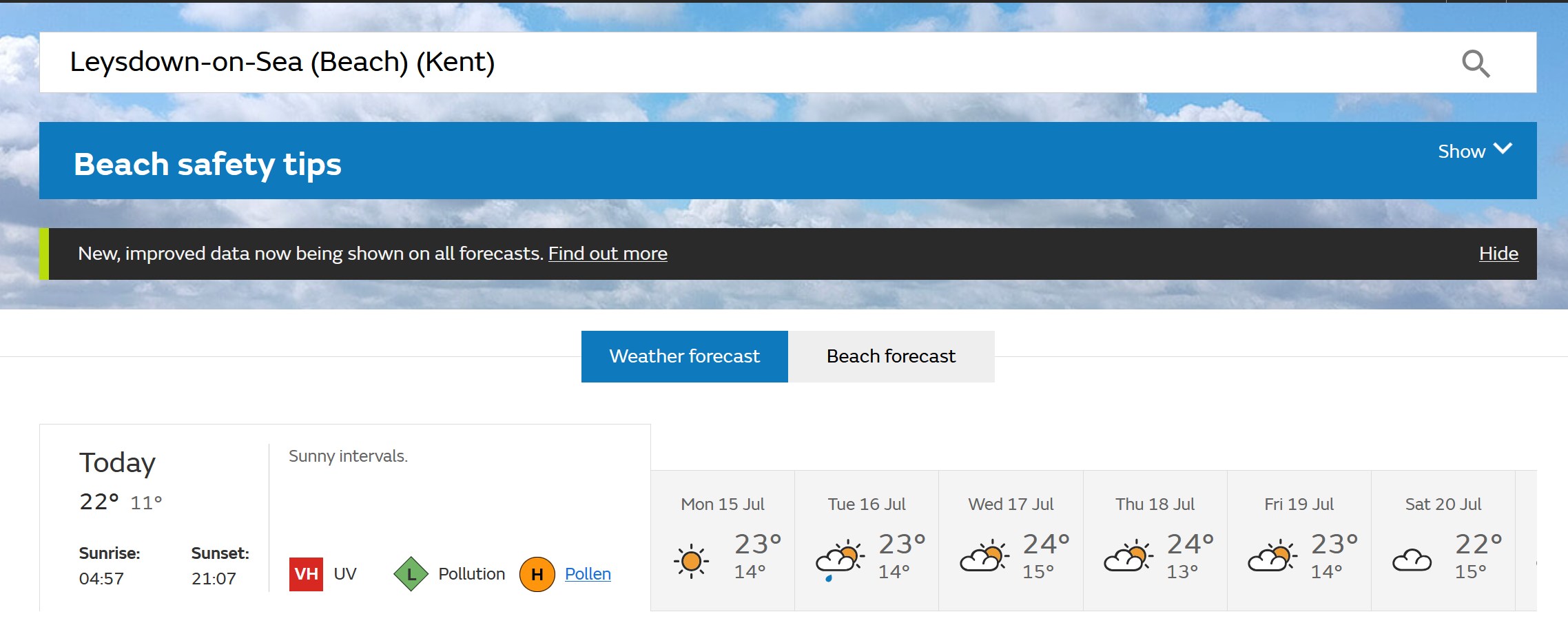
yet the accompanying text forecast for the SE says:

"Very hot for most and remaining humid with long spells of very strong sunshine across the region. Some mist could affect southern coasts, especially towards Sussex and Kent. Winds remaining light. Maximum temperature 34 °C."

I'm sure Leysdown isn't the only gridpoint to be showing 35, so either a) they're ignoring it, which isn't a good look or b) the model is over-egging the temperatures, in which case the bias needs to be fixed. 

Incidentally despite all the chatter about cool, unsettled conditions, the MetO text forecast closes with this:

"Outlook for Thursday to Saturday:

Dry and bright Thursday and Friday with some cloud. Chance of an afternoon shower on Thursday. Saturday breezy with increasing chance of showers or rain. Temperatures remaining above normal."

I'd say less settled rather than unsettled (which to me would mean windy, frequent or prolonged rain, typical autumnal low pressure weather), and note the end bit - "temperatures remaining above normal". No surprise there of course!


Leysdown, north Kent
Heavy Weather 2013
01 July 2025 04:39:44
GFS is out to next Tuesday and we’re back up to 27 by then with a 29C by Wednesday.

The only days where the temperatures return to average or thereabouts is Sunday/Monday. 

Let’s not forget this week at one point a few days ago it was looking a bit rubbish after the heat, but in the end for those in the south it remains very warm. 

Let’s see what the remainder of the run brings


Mark

Beckton, E London

Less than 500m from the end of London City Airport runway.

Heavy Weather 2013
01 July 2025 05:14:52

The rest of the run is basically hot to very hot  from next Tuesday onwards. 


Mark

Beckton, E London

Less than 500m from the end of London City Airport runway.

Brian Gaze
01 July 2025 05:45:59

Astonishing GFS 00Z this morning. If it verifies we'll be on track for one of the hottest summers ever, despite there being half of the season left.

UserPostedImage


Brian Gaze

Berkhamsted

TWO Buzz - get the latest news and views 

"I'm not socialist, I know that. I don't believe in sharing my money." - Gary Numan

Ally Pally Snowman
01 July 2025 05:49:49

Yep 1976 on this mornings GFS, AIFS is more unsettled though, GEM a half way house.


Bishop's Stortford 85m ASL.
NMA
  • NMA
  • Advanced Member
01 July 2025 05:51:17
I'll echo most of these comments above but add my own example for confusing modelling - from the BBC this time.

Tomorrow's forecast for Dorset, Hampshire and IOW.

Tomorrow will see a cloudy and wet start with heavy bursts of rain pushing north-eastwards. These will gradually clear away through the afternoon, with sunshine developing in behind. Less warm.

Yet the BBC pictorial output mentions no rain whatsoever and has almost wall to wall sunshine for the same period and places.

Edit. Just read the Met Office take on tomorrow. No rain mentioned in both text and pictorials. Really incredible the inconsistencies in their modelling or whatever they do to create a forecast.


Vale of the Great Dairies

South Dorset

Elevation 60m 197ft

Retron
01 July 2025 06:51:58

Looks truly unbearable here this afternoon - my poor pup was most unimpressed the other day when it reached 32, but 35 is on the menu today. As an aside, the UVK captures the foehn effect from the North Downs perfectly! (Image via TWO).

https://www.theweatheroutlook.com/charts3/ukv/ukv_custom/ukv_2025_JUL_01_03_12_2mmaxtemp_50.9_0.4_1.png 

UserPostedImage


Leysdown, north Kent
Heavy Weather 2013
01 July 2025 07:04:42

Looks truly unbearable here this afternoon - my poor pup was most unimpressed the other day when it reached 32, but 35 is on the menu today. As an aside, the UVK captures the foehn effect from the North Downs perfectly! (Image via TWO).

https://www.theweatheroutlook.com/charts3/ukv/ukv_custom/ukv_2025_JUL_01_03_12_2mmaxtemp_50.9_0.4_1.png 

UserPostedImage

Originally Posted by: Retron 

Omg. Is that a 36-37 I see on there


Mark

Beckton, E London

Less than 500m from the end of London City Airport runway.

Rob K
01 July 2025 07:08:49

Omg. Is that a 36-37 I see on there

Originally Posted by: Heavy Weather 2013 

Yes UKV has some 37s on the north side of the Thames Estuary. Nowhere that would be captured officially. 

ARPEGE and GFS don’t seem to go higher than 34 today. 


Yateley, NE Hampshire, 73m asl

"But who wants to be foretold the weather? It is bad enough when it comes, without our having the misery of knowing about it beforehand." — Jerome K. Jerome

ballamar
01 July 2025 07:18:28

Looks truly unbearable here this afternoon - my poor pup was most unimpressed the other day when it reached 32, but 35 is on the menu today. As an aside, the UVK captures the foehn effect from the North Downs perfectly! (Image via TWO).

https://www.theweatheroutlook.com/charts3/ukv/ukv_custom/ukv_2025_JUL_01_03_12_2mmaxtemp_50.9_0.4_1.png 

UserPostedImage

Originally Posted by: Retron 

Really is unusual to be that hot on the coast in Essex 

Heavy Weather 2013
01 July 2025 07:20:27

Yes UKV has some 37s on the north side of the Thames Estuary. Nowhere that would be captured officially. 

ARPEGE and GFS don’t seem to go higher than 34 today. 

Originally Posted by: Rob K 

Yep. A damning incitement of our recoding network.

btw, do you know where o can get current temperatures. My go to weather online seems to now charge for that data.


Mark

Beckton, E London

Less than 500m from the end of London City Airport runway.

Rob K
01 July 2025 07:37:35

Yep. A damning incitement of our recoding network.

btw, do you know where o can get current temperatures. My go to weather online seems to now charge for that data.

Originally Posted by: Heavy Weather 2013 

Weatherobs is very good and shows virtually every automatic station (it has a lot of unofficial sites too but you can turn them off in the settings).

It shows Manston is currently hottest: 26.8C with a dewpoint of 20.4C.... at 8am!

East is definitely best (or worst!) today.


Yateley, NE Hampshire, 73m asl

"But who wants to be foretold the weather? It is bad enough when it comes, without our having the misery of knowing about it beforehand." — Jerome K. Jerome

TheJudge
01 July 2025 07:50:54

Weatherobs is very good and shows virtually every automatic station (it has a lot of unofficial sites too but you can turn them off in the settings).

It shows Manston is currently hottest: 26.8C with a dewpoint of 20.4C.... at 8am!

East is definitely best (or worst!) today.

Originally Posted by: Rob K 

Great site, saved it, although when I turned off CWOP data I lost the map, even after refresh. Might be my phone will try it on a pc. Heathrow highest at present. I expect at 36 or 37 at some point today in the SE.


Barby 551 ft above sea level
Devonian
01 July 2025 07:58:19

Astonishing GFS 00Z this morning. If it verifies we'll be on track for one of the hottest summers ever, despite there being half of the season left.

UserPostedImage

Originally Posted by: Brian Gaze 

A dry and record warm spring after a very mild winter and '430' - the cards are all in place and not a few here noticed that in April. Will it (a 2025 repeat of 1976) happen? I bleeping well hope not!

But, if it does, I will note the irony of the people who can't get enough withering heat (so, most of the population of this country it seems) whining on about using hose pipes/higher food prices.

Rob K
01 July 2025 07:58:55

Great site, saved it, although when I turned off CWOP data I lost the map, even after refresh. Might be my phone will try it on a pc. Heathrow highest at present. I expect at 36 or 37 at some point today in the SE.

Originally Posted by: TheJudge 

It's not brilliant on mobile, and the functionality to show past data by clicking a station doesn't work. On desktop it's very useful.

BTW does anyone know if Brogdale is still running? It's a manual station so the high wouldn't be known until after 10am tomorrow if so.


Yateley, NE Hampshire, 73m asl

"But who wants to be foretold the weather? It is bad enough when it comes, without our having the misery of knowing about it beforehand." — Jerome K. Jerome

01 July 2025 10:02:20

Some cumulonimbus bubbling up west of London

Could be a home grown or 2 today


Berkshire
Saint Snow
01 July 2025 10:21:03

The broad trend for the first half of July hasn't substantially changed in days on the GFS - AH ridging over the UK from the west, but susceptible to attacks of low pressure from the north.

AIFS this morning shows a generally more unsettled picture as lows dominate from the north with more frequency; in the second half of the run the AH is centred several hundred miles further south out in the Atlantic, allowing the lows to displacing the ridging AH for most of the run.


Martin

Home: St Helens (26m asl) Work: Manchester (75m asl)

A TWO addict since 14/12/01

"How can wealth persuade poverty to use its political freedom to keep wealth in power? Here lies the whole art of Conservative politics."

Aneurin Bevan

Ally Pally Snowman
01 July 2025 11:16:03

GFS 6z turns into another 1976er. 


Bishop's Stortford 85m ASL.
Ally Pally Snowman
01 July 2025 12:04:57

Latest AIFS 6z is more of a continuation of the SE/NE split. Hot at times in the SE but cooler more unsettled further NW.


Bishop's Stortford 85m ASL.

Remove ads from site