The Weather Outlook

Remove ads from site

Matty H
03 February 2025 10:52:40

I'm sure it'll find a way to go wrong from here but interesting reorientation of the HP at T276:-

UserPostedImage

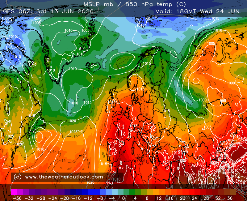
Variation on a theme of course and I expect there will be some ens members that have the HP sat so that cold lobe is heading SW through the med and Atlantic fronts are pushing milder air towards us.

Still, pretty looking set of pixels šŸ˜‰

Originally Posted by: Hippydave 

What's going to prop this high up?


Yate, Nr Bristol

TBFTEIARBSC

Hippydave
03 February 2025 11:02:22

What's going to prop this high up?

Originally Posted by: Matty H 

The hopes and optimism of a thousand cold rampers 😜

I edited a moment ago to say the HP does start sagging in the end but lasts long enough to get the intense cold to the south.Ā  I'll wait for the ens but suspect this run is a triumph of timing and positioning, that may come off but won't be well supported so probably won't.Ā 

The HP currently looks fairly likely to be meandering around somewhere to our east for the next 14 days or so and whilst that pattern persists it does give more chances for something like the 6z op to come off, although the form horse is the typical slow decline and meander back to more atlantic influence for us. Still, it's more fun winning a bet on an outsider than backing the favourite.Ā 

Edit: On the propping front and being a bit more serious I think you do sometimes see that the cold push 'self sustains' by causing instability on the southern flank and as long as nothing moves the HP too much it allows the cold pool to barrel westwards a bit like a boat on rollers, with the HP sat on top and propped by the dense air and instability. Happy for someone to tell me that's rubbish though!


Home: Tunbridge Wells

Work: Tonbridge

ballamar
03 February 2025 11:10:41

What's going to prop this high up?

Originally Posted by: Matty H 

It might be there isn’t a lot to sink it either. This however great it looks for cold would probably end up with a weaker easterly feed and the main cold in the continent. As you say a low beneath it would make the scenario more plausible no matter how the signals support a Scandi high. Nice to look at though

Hippydave
03 February 2025 11:21:11
At the risk of making this thread all about me making admiring comments of unlikely to verify deep FI charts, the 6z really is a cracking run and shows that persisting pattern cold reload/second wave thingy that turns this from a chilly cold interlude but nothing too exciting to a proper 'cold spell'. I just need to remind myself it's all rather unlikely and not to feel cheated when it's gone on the 12z and/or the ens shows it's an outlier.

Picking up ballamars 'not too much to sink it' comment, I think the jet chart shows that quite nicely:-

UserPostedImage

No real activity to the north, strong jet streak exiting N.America/Canada but heading due south and a robust southern arm of the jet all suggest there's no particular reason for the high to sink.Ā Ā 

The kicker on these things is usually when the models tweak the jet orientation or it spins a LP up that diverts it and the whole thing collapses away over one or two runs.Ā 


Home: Tunbridge Wells

Work: Tonbridge

Matty H
03 February 2025 11:23:07

It might be there isn’t a lot to sink it either. This however great it looks for cold would probably end up with a weaker easterly feed and the main cold in the continent. As you say a low beneath it would make the scenario more plausible no matter how the signals support a Scandi high. Nice to look at though

Originally Posted by: ballamar 

Exactly, and Hippy mentions it starting to sag, which it will without that low or train of lows to keep it propped up. Is there any theme of that in any of ens? I don't think there is?


Yate, Nr Bristol

TBFTEIARBSC

ballamar
03 February 2025 11:51:23

Exactly, and Hippy mentions it starting to sag, which it will without that low or train of lows to keep it propped up. Is there any theme of that in any of ens? I don't think there is?

Originally Posted by: Matty H 

Themes difficult to come by might be a case of wait and see. As long as the models aren’t taken as gospel and people view them as potential! Historically would favour a sinking high into south Eastern Europe - something about this period makes me think that might not be the case!Ā 

Brian Gaze
03 February 2025 12:55:15
GEFS 06Z updates look a tad colder than the 00Z ones. Personally, I wouldn't reach much into it one way or the other.

UserPostedImage


Brian Gaze

Berkhamsted

TWO Buzz - get the latest news and views 

"I'm not socialist, I know that. I don't believe in sharing my money." - Gary Numan

Snow Hoper
03 February 2025 12:55:36
2nd dip very much in the minority on the 06z ens.
Going to war over religion is like killing each other to see who has the better imaginary friend.

Home : Mid Suffolk.

48m Asl

Gandalf The White
03 February 2025 12:59:19

Exactly, and Hippy mentions it starting to sag, which it will without that low or train of lows to keep it propped up. Is there any theme of that in any of ens? I don't think there is?

Originally Posted by: Matty H 

The only theme in the ensembles after the coldish few days later this week is of uncertainty. Everything is on offer from very cold through to a little above normal. Ā As we all know, we need every bit of the jigsaw puzzle to fall just right, and stay there.


Location: South Cambridgeshire

130 metres ASL

52.0N 0.1E


fairweather
03 February 2025 13:04:38
There is some dilution of cold prospects from a few days ago. I've lost my enthusiasm for long term speculation these days whilst I understand why others still enjoy it. The form horse of course is a 4 day cold spell with little in the way of heavy snow.
S.Essex, 42m ASL
Brian Gaze
03 February 2025 14:44:03
I've moved the Met Office lrf discussion to the Media Thread. šŸ‘
Brian Gaze

Berkhamsted

TWO Buzz - get the latest news and views 

"I'm not socialist, I know that. I don't believe in sharing my money." - Gary Numan

ballamar
03 February 2025 16:52:37
GFS op run lining up for a blast from the NEĀ 

Incoming….

GFS op clearly overdoing the 2m temps on this run - would be sub zero for most. Enjoyable to see good synoptics back

Rob K
03 February 2025 17:22:23

GFS op run lining up for a blast from the NEĀ 

Incoming….

GFS op clearly overdoing the 2m temps on this run - would be sub zero for most. Enjoyable to see good synoptics back

Originally Posted by: ballamar 

Yes I was surprised to see 3-4C maxes with a -12 to -13C feed of air from the east.


Yateley, NE Hampshire, 73m asl

"But who wants to be foretold the weather? It is bad enough when it comes, without our having the misery of knowing about it beforehand." — Jerome K. Jerome

Jiries
03 February 2025 17:31:48

Yes I was surprised to see 3-4C maxes with a -12 to -13C feed of air from the east.

Originally Posted by: Rob K 

Less cold temps does not excite me at all and checking with Rovaniemi going for less cold tempsĀ  to 1c by following Tuesday, way too high for that region in Arctic circle.Ā  Could be they are wrong and the maxes 3-4C being wrong too, should be -2 to -3C day time maxes.

Less cold temps is my enemy and no fun or enjoyment out of it.Ā  Ā 

Rob K
03 February 2025 17:57:07
P10 of the 12Z GEFS is a bit of an eye-opener.
Yateley, NE Hampshire, 73m asl

"But who wants to be foretold the weather? It is bad enough when it comes, without our having the misery of knowing about it beforehand." — Jerome K. Jerome

Brian Gaze
03 February 2025 17:58:26
UM looks quite underwhelming. Some GEFS runs have some high latitude blocking.

UserPostedImage


Brian Gaze

Berkhamsted

TWO Buzz - get the latest news and views 

"I'm not socialist, I know that. I don't believe in sharing my money." - Gary Numan

Rob K
03 February 2025 18:01:30

UM looks quite underwhelming. Some GEFS runs have some high latitude blocking.

UserPostedImage

Originally Posted by: Brian Gaze 

Underwhelming in terms of 850s up to 168hrs but looks like a solid block?

There are some absolute corkers on the GEFS (but also plenty of dross)


Yateley, NE Hampshire, 73m asl

"But who wants to be foretold the weather? It is bad enough when it comes, without our having the misery of knowing about it beforehand." — Jerome K. Jerome

warrenb
03 February 2025 18:07:38
ECM goes north at 72h
jhall
03 February 2025 18:08:02
I would have been more encouraged by two successive GFS OP runs with severe cold in FI if the routes for getting there hadn't been so different. Some run-to-run consistency would be nice.
Cranleigh, Surrey
Taylor1740
03 February 2025 19:10:01
The chance of any deep cold past mid-February has almost vanished completely on the GEFS 12z.
NW Leeds - 150m amsl
ballamar
03 February 2025 19:37:08
Bit more positive for cold outlook today in the models, always good to have the Met update favouring it as well. But still a while off before any sort of cold with the first push 5 days away.Ā 
White Meadows
03 February 2025 20:13:16
ECM ā€˜AI’ is absolutely ridiculous tonight.Ā 

jhall
03 February 2025 21:14:52
Interesting that into FI - though the details differ - GFS OP, ECM OP and AIFS all go for a push of very cold air down from the Arctic that reaches us either on a fairly direct route from the NE or by a more round-about route so it eventually reaches us as an easterly.Ā 
Cranleigh, Surrey
nsrobins
03 February 2025 22:51:06

ECM ā€˜AI’ is absolutely ridiculous tonight.Ā 

Originally Posted by: White Meadows 

And far FI of GFS again likely to be an absolute snorter.


Neil

Fareham, Hampshire 28m ASL (near estuary)

Stormchaser, Member TORRO

Rob K
03 February 2025 23:00:39

The chance of any deep cold past mid-February has almost vanished completely on the GEFS 12z.

Originally Posted by: Taylor1740 

Reallly? There are some very cold options on there. Five including the op run go below -10C in London after mid month.Ā 


Yateley, NE Hampshire, 73m asl

"But who wants to be foretold the weather? It is bad enough when it comes, without our having the misery of knowing about it beforehand." — Jerome K. Jerome

Remove ads from site