The Weather Outlook

Remove ads from site

Hippydave
13 January 2024 17:44:06
IMBY bit of post:

So, for this evenings Op runs and Wednesday's ongoing teasing low we have:-

GFS - runs along the southern coastal strip bringing a spell of snow for a few hours, suggestion there's likely to be some rain involved too although it's mostly snow. 

ICON - same positioning as GFS, doesn't seem to be showing any rain so hopefully all snow. 

GEM - Precip stays just in the Channel before pivoting slightly and bringing snow to parts of Hampshire, Sussex and Kent. 

UKMO - LP stays a reasonable distance to the South although does appear to induce enough instability for some light snow showers in the SE corner. 

Must admit I was expecting this evenings runs to remove the carrot for MBY but obviously not. If the ECM follows UKMO and the ens back up the  Euros Ops I'd say time to forget about that LP as seems unlikely they'd both be wrong, although maybe tomorrow's 12zs would be a better time to give up as we're only talking micro adjustments to the precip band positioning.

Not IMBY:

Steady as she goes so far - a bit more amplification again in some of the runs suggesting a day or so delay of cold being swept away and GFS again toying with cool zonality, or as we far southerners like to call it,  zonality😋 GFS ends blocked and rather chilly, so more hints that we're maybe not looking at a long unsettled spell. 

Okay it's GEM and it does like to show snow but the op had 2 features crossing Scotland that bring some organised snow - one Tuesday and the other Friday. So could be frequent snow showers Sunday, Monday, Weds and Thursday and more organised snow fall Tuesday and Friday. Not too shabby if it did happen as GEM shows, but the snow showers for a chunk of Scotland look essentially certain even if it didn't verify. 

UKV has some lying snow for quite a few north western parts of England (pretty much to the coast) for the early hours of Tuesday before the little LP moves through and potentially adds more although UKV looks to be suggesting it's marginal and height will be a factor in how much lying snow there is particularly on the southern flank of the precip:-
UserPostedImage

Okay there's a big swath of nothing there too as you'd expect in the setup but this still looks like it's going to be relatively short but very sweet for some and there's still a chance more folks get involved if any features crop up and/or that LP does prove my pessimism wrong and skirt the far south.


Home: Tunbridge Wells

Work: Tonbridge

Retron
13 January 2024 17:48:34

The mean precipitation line is getting further north. 🙏


Originally Posted by: Ally Pally Snowman 

Your gain is our pain - for plenty of members now show heavy rain down here. (Even the op has a mix of rain and sleet for coastal Kent).

What we're looking for really is mean snowfall, rather than mean rain (as shown on the chart you linked); one of the things about the snow showers on Monday was that it appeared as mean snow. That's pretty rare, and worth taking note of when it happens!


Leysdown, north Kent
Ally Pally Snowman
13 January 2024 17:53:22

Your gain is our pain - for plenty of members now show heavy rain down here. (Even the op has a mix of rain and sleet for coastal Kent).

What we're looking for really is mean snowfall, rather than mean rain (as shown on the chart you linked); one of the things about the snow showers on Monday was that it appeared as mean snow. That's pretty rare, and worth taking note of when it happens!

Originally Posted by: Retron 

Yes it's a very fine line. But nice to see a growing chance of seeing snow even if its still an outside bet.


Bishop's Stortford 85m ASL.
Heavy Weather 2013
13 January 2024 17:55:17

Yes it's a very fine line. But nice to see a growing chance of seeing snow even if its still an outside bet.


Originally Posted by: Ally Pally Snowman 

Also, maybe just me but there looks to be some sort of feature tomorrow no?


Mark

Beckton, E London

Less than 500m from the end of London City Airport runway.

Ally Pally Snowman
13 January 2024 17:59:33

Also, maybe just me but there looks to be some sort of feature tomorrow no?

Originally Posted by: Heavy Weather 2013 

Maybe yes, could see a flurry or two.

https://www.wetterzentrale.de/en/topkarten.php?map=20&model=gem&var=4&run=12&time=30&lid=OP&h=0&mv=0&tr=3#mapref 


Bishop's Stortford 85m ASL.
Gandalf The White
13 January 2024 18:15:31

The mean precipitation line is getting further north. 🙏

https://www.meteociel.fr/modeles/gefs_cartes.php?code=31&ech=102&mode=2&carte=0&ext=0 


Originally Posted by: Ally Pally Snowman 

Intereresting - the mean is about 100 miles further north than the Op.

Meanwhile I was surprised to see the ensembles showing a better than evens chance of some light snow tomorrow for eastern parts as the trough drifts south.


Location: South Cambridgeshire

130 metres ASL

52.0N 0.1E


Rob K
13 January 2024 18:17:40

Maybe yes, could see a flurry or two.

https://www.wetterzentrale.de/en/topkarten.php?map=20&model=gem&var=4&run=12&time=30&lid=OP&h=0&mv=0&tr=3#mapref 


Originally Posted by: Ally Pally Snowman 

I would have thought that anything that falls from the sky tomorrow across the south would be wet rather than white?


Yateley, NE Hampshire, 73m asl

"But who wants to be foretold the weather? It is bad enough when it comes, without our having the misery of knowing about it beforehand." — Jerome K. Jerome

Ally Pally Snowman
13 January 2024 18:25:32

I would have thought that anything that falls from the sky tomorrow across the south would be wet rather than white?

Originally Posted by: Rob K 

Well GEM has -7c 850s 2m temps of 2c at that time. Touch and go.


Bishop's Stortford 85m ASL.
Ally Pally Snowman
13 January 2024 19:07:10
13c 850s in the South remarkable warmth. Close to record levels for January. 

https://www.wetterzentrale.de/en/topkarten.php?map=20&model=ecm&var=2&run=12&time=240&lid=OP&h=0&mv=0&tr=24#mapref 


Bishop's Stortford 85m ASL.
Heavy Weather 2013
13 January 2024 19:18:12
Although ECM doesn’t have the front into the south. It shifted quite a bit north.

https://x.com/hampweather/status/1746236979547685294?s=46&t=0CzXil3QOYbo8W1abHQyVQ 

Wednesday does feel in play again considering the movement today.


Mark

Beckton, E London

Less than 500m from the end of London City Airport runway.

Tim A
13 January 2024 19:43:46
Tuesdays feature for N England looks like it will be a nowcast. Running the sequence on UKV shows a complex situation with bits and pieces of snow early Tuesday and later Tuesday, hard to work out what is going on and will no doubt change right down to the hour. 
Tim

NW Leeds

187m asl

 My PWS 

CField
13 January 2024 20:35:54
Looking at the potential southern snowfall (on the assumption it travels far enough north) , checking the Met Office radar precipitation forcast maps ( assuming again there is a slight sw-ne axis) East Sussex Kent will be hardest hit.The front will hit this area around 3am in darkness after a fair frost which will be a good thing forr initial accumulations.The precipitation will be a mostly light nature on its northern edge with the heaviest in the rain zone .( Channel N France).

The more pronounced the SW-NE axis could increase the rain risk to East Kent but increase the snow risk to West Kent especially if the end of the system which shows the heaviest precipitation with a potential very cold undercut which could produce some heavy snow. That's just one favoured scenario , we all know the other options.


Favourite snowstorm

Famous channel low

Dec 31st 1978

Hastings East Sussex

Foot of level snow severe drifting

Next day max temp -4 degrees Celsius

fairweather
13 January 2024 20:36:38
Looking at the ensembles (12z) if  that Wednesday mean can drop to -6C in the South, and it might well do, I think it will be more snow than rain given it's only brief will very cold air immediately before and after. So IMBY it's more a question of will it trundle far enough north and stick around for a few hours.
S.Essex, 42m ASL
Zubzero
13 January 2024 20:42:10

The mean precipitation line is getting further north. 🙏

https://www.meteociel.fr/modeles/gefs_cartes.php?code=31&ech=102&mode=2&carte=0&ext=0 


Originally Posted by: Ally Pally Snowman 

Not really as the mean is skewed by a few outliers. In this situation the mean is not very useful 

https://www.meteociel.fr/cartes_obs/gens_display.php?x=318&y=101&run=12&runpara=0&type=10&ext=1 


Hippydave
13 January 2024 20:43:15
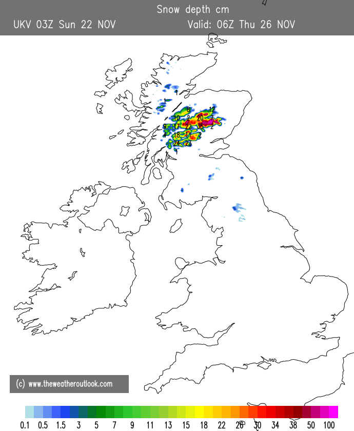
UserPostedImage

Okay the above is a bit of fun and shouldn't be taken as gospel but the UKV snow depth chart really is something else for the far North of Scotland - unlike the blob of 99cm in the Cairngorms, the 66cm in the North West is all from Sunday onwards. I assume that's higher ground but even so there's a wide swath of 40+cm up there and even away from the really exposed parts 10-20cm is widespread.  (If I was in the strip running East towards Edinburgh I'd be a bit miffed if that verified given the snow above around me).

This particular run has also swung back to a bit more precip for Wales and still has the snow for parts of the NW.

IMBYish I did also have a quick look at MOGREPs (Brighton) and there's 4 members that bring a decent fall of snow midweek, so around 25%. ECM also has a few members still, albeit not a lot and the ens mean for 24hr snowfall is 0.6mm.....


Home: Tunbridge Wells

Work: Tonbridge

Saint Snow
13 January 2024 21:34:21

UserPostedImage

Okay the above is a bit of fun and shouldn't be taken as gospel but the UKV snow depth chart really is something else for the far North of Scotland - unlike the blob of 99cm in the Cairngorms, the 66cm in the North West is all from Sunday onwards. 


Originally Posted by: Hippydave 

A breathtakingly beautiful area, too.

I'm hoping Tuesday/Wednesday will bring me some snow, but that mild sector worries me. 


Martin

Home: St Helens (26m asl) Work: Manchester (75m asl)

A TWO addict since 14/12/01

"How can wealth persuade poverty to use its political freedom to keep wealth in power? Here lies the whole art of Conservative politics."

Aneurin Bevan

doctormog
13 January 2024 21:37:30
The Flow Country becomes the Snow Country?


Russwirral
13 January 2024 22:16:19
Much different 2nd half of this gfs run tonight... solid rather than stransient ridge HP cell forming rather than straight to a atlantic onslaught

Very interesting development.

More energy over Iberia too,... has all the potential to go very close to a Scandi high this...


Polar Low
13 January 2024 22:18:42
Another shift North from Icon quite a bit of snow for the south and s/e

https://www.meteociel.fr/modeles/icon-eu.php?ech=93&mode=1&map=500 


doctormog
13 January 2024 22:19:28

Much different 2nd half of this gfs run tonight... solid rather than stransient ridge HP cell forming rather than straight to a atlantic onslaught

Very interesting development.

More energy over Iberia too,... has all the potential to go very close to a Scandi high this...

Originally Posted by: Russwirral 

There were hints of this on the 12z op run too. I wonder if it’s a blip or the start of a trend. I guess we will know a little more tomorrow.


Polar Low
13 January 2024 22:26:09
That’s all snow away from the south coast and s/w, good bet a ice day in that snow band if icon is to be believed.

https://www.meteociel.fr/modeles/icon-eu.php?ech=93&mode=42&map=500 


Polar Low
13 January 2024 22:51:21
Interesting developments gfs more  members holding onslaught off prolonging cold under a U.K. high

https://www.meteociel.fr/modeles/gefs_cartes.php?code=24&ech=138&mode=0&carte=0&ext=0 

Russwirral
13 January 2024 23:16:54

Interesting developments gfs more  members holding onslaught off prolonging cold under a U.K. high

https://www.meteociel.fr/modeles/gefs_cartes.php?code=24&ech=138&mode=0&carte=0&ext=0 

Originally Posted by: Polar Low 

Be interesting if this continues tomorrow, if it does, id say game on for a very interesting week.... if we have chewed through 3 pages by 10am tomorrow ill know my answer.


SnowyHythe(Kent)
14 January 2024 00:06:50
18z icon has been to the pub.

https://www.meteociel.fr/modeles/icon-eu.php?ech=3&mode=1&map=510 


ballamar
14 January 2024 04:27:57
Signs that Wednesday could mean snow for many in the south 

Remove ads from site