The Weather Outlook

Remove ads from site

doctormog
31 December 2023 10:25:10
January 1795 was a remarkable month. 

January 2024 will hopefully prove to be drier than this month. The 06z GFS op run so far continues the more anticyclonic theme.


Whiteout
31 December 2023 10:37:33

Today's ensemble watch is the coldest set yet.

The upcoming pattern change is a little clearer today. It looks like pressure will rise in the vicinity of the UK at the end of the week, which can only be a good thing for those who are fed up with wind and rain. In the process of doing so, there will be some cold air pushed south, clipping Scotland and then largely passing to the east. This should, however, help to ensure there are some clear skies under the high, leading to widespread frost (as shown on the UK text outlook).

Beyond that the high will decline, as they usually do, but then thanks to the upstream pattern being favourable it'll either be pulled westwards, or a new high will form to the west. This will then pull another pulse of cold air southwards and, at the moment, the ensembles favour that to be a good deal colder than next weekend's effort. It's from this point onwards that the chances of snow begin to rise, moreso if the ridge ends up far enough north and east to engage the exceptionally cold air over Scandinavia.

That's one of the scenarios, anyway. Another scenario is that after next weekend's high declines, the ridging to the west fails to build much, meaning less (or no) cold air is pushed over the UK and we sink back into the status quo. At the moment, though, that's the lesser chance - the majority of the output is showing a colder, more settled interlude on the way. Whether that then extends to a cold spell remains to be seen, but in

the meantime I'm just grateful to see the end of this relentless zonality coming into view.

https://ukwct.org.uk/weather/enswatch.jpg?31 
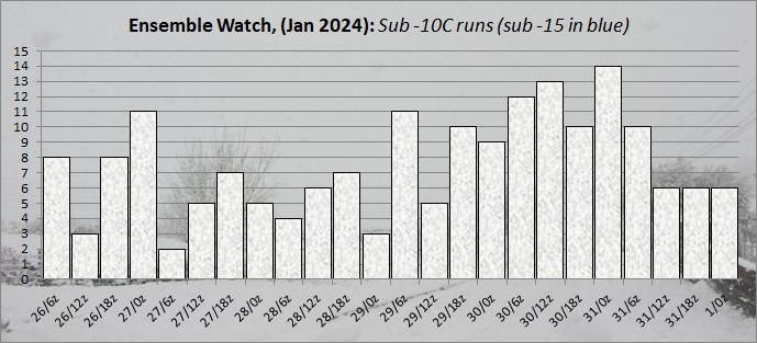
UserPostedImage


Originally Posted by: Retron 

Super summary Darren, we are lucky to have you on this forum, way too much guff on NW, no wonder newbies get confused. Patience is needed and you match pretty much what the Met allude to on the extended forecasts. Whatever happens it is going to finally dry up, frosts incoming and from there who knows, but the most interesting Jan for many a year….


Home/Work - Dartmoor

240m/785 ft asl

The Beast from the East
31 December 2023 10:40:10
High holding up better on this latest GFS
Purley, Surrey, 70m ASL

"We have some alternative facts for you"

Kelly-Ann Conway - former special adviser to the President

fairweather
31 December 2023 10:54:59

After a poor GEM and GFS , ECM produces the goods -10c 850s on an easterly just a week away.

https://www.wetterzentrale.de/en/topkarten.php?map=1&model=ecm&var=2&run=0&time=168&lid=OP&h=0&mv=0&tr=24#mapref 


Originally Posted by: Ally Pally Snowman 

Like I said a couple of days ago. Things tend to flip at a week away and don't drift slowly into a cold spell over two weeks. We are now in the phase of how cold as it changes one way or the other over the next few days. At the moment I think we can say next week will be colder, drier and less windy than of late. Not sure about sunshine though.


S.Essex, 42m ASL
nsrobins
31 December 2023 10:58:06

Super summary Darren, we are lucky to have you on this forum, way too much guff on NW, no wonder newbies get confused. Patience is needed and you match pretty much what the Met allude to on the extended forecasts. Whatever happens it is going to finally dry up, frosts incoming and from there who knows, but the most interesting Jan for many a year….

Originally Posted by: Whiteout 

Now I know something must be brewing😂⚠️

It’s very finely balanced, and the medium term could go in a number of directions. As an example the 06 GFS from 300 is a chink away from delivering something very cold indeed.


Neil

Fareham, Hampshire 28m ASL (near estuary)

Stormchaser, Member TORRO

Rob K
31 December 2023 11:01:15
6Z GFS looks like proper retrogression - as always it's at 12-14 days out, where it usually remains until March.

I am hoping that ECM is on the money for next weekend - I'm off to Wales MTBing and a cold sunny frosty high would be welcomed rather than the muck we have at the moment. Even on rocky terrain it's still minging when it's this wet.


Yateley, NE Hampshire, 73m asl

"But who wants to be foretold the weather? It is bad enough when it comes, without our having the misery of knowing about it beforehand." — Jerome K. Jerome

Rob K
31 December 2023 11:06:33
The GFS 348 hour chart is a thing of beauty... that would put an end to the "no cold Januaries" spell.
Yateley, NE Hampshire, 73m asl

"But who wants to be foretold the weather? It is bad enough when it comes, without our having the misery of knowing about it beforehand." — Jerome K. Jerome

doctormog
31 December 2023 11:08:41
Polar Vortex what Polar Vortex?

UserPostedImage


jhall
31 December 2023 11:10:33

😂 Love these little typos!  

Originally Posted by: Caz 

I suspect that, though no doubt tongue in cheek, "1795" wasn't a typo. Isn't it the coldest January in the CET series?


Cranleigh, Surrey
jhall
31 December 2023 11:14:45
Unusual degree of consistency between the 0Z and 06Z GFS op runs all the way to the end of FI. Presumably more of a fluke than anything else. 
Cranleigh, Surrey
Ally Pally Snowman
31 December 2023 11:27:32

I suspect that, though no doubt tongue in cheek, "1795" wasn't a typo. Isn't it the coldest January in the CET series?

Originally Posted by: jhall 

Indeed.

As for the here and now January 24 looks very dry and coldish atm. 


Bishop's Stortford 85m ASL.
White Meadows
31 December 2023 11:29:10
Beginning to feel like the fork road is approaching, but we have a bit more time in the waiting room yet. Some of the hallmarks needed for severe widespread cold are there still, at least for now. 

A calmer and cooler period is pretty much nailed down but it’s going to be fascinating watching what happens next, especially with the absence of  cantankerous posts driving away the knowledgeable and giving members in here of late. 

Ally Pally Snowman
31 December 2023 11:43:13
Having said January was looking dry still plenty of GFS ensembles have a snowy look to them. P12 and P21 for example. 
Bishop's Stortford 85m ASL.
Downpour
31 December 2023 11:43:27
At last we do seem to have a decent signal for something drier. I’m sure that at least will unite TWOers. The ground is sodden and getting out of the house into the fresh air has been near impossible during what has been yet another dismal festive period. 

We might actually record a dry day on Tuesday. A huge turn up for the books in and of itself. 


Chingford

London E4

147ft

doctormog
31 December 2023 12:00:46
Total cherry-picking alert! P26 looks interesting…

https://www.wetterzentrale.de/maps/GFSP26EU06_306_1.png 


DPower
31 December 2023 12:01:00
The initial push of heights up towards Greenland that has been advertised in the models the last few days ( gfs never really came on board apart from yesterdays 12z run) looks like it has lost some traction. Always wary when cold synoptics keep getting delayed. Not buying into the teleconnect talk that is rife on the other forum. The strat is leading this dance.
CField
31 December 2023 12:09:26
Are we going to see the SE micro climate come into play this winter..usually applies more to extreme heat
Favourite snowstorm

Famous channel low

Dec 31st 1978

Hastings East Sussex

Foot of level snow severe drifting

Next day max temp -4 degrees Celsius

Saint Snow
31 December 2023 12:13:54

We might actually record a dry day on Tuesday. A huge turn up for the books in and of itself. 

Originally Posted by: Downpour 

Given it's the day most go back to work after the festive break, it's not really that much of a surprise 😉


Martin

Home: St Helens (26m asl) Work: Manchester (75m asl)

A TWO addict since 14/12/01

"How can wealth persuade poverty to use its political freedom to keep wealth in power? Here lies the whole art of Conservative politics."

Aneurin Bevan

Brian Gaze
31 December 2023 12:21:38
I agree with Darren's earlier post about the models favouring a second cold plunge. However, adding more moving parts to the mix massively increases the chance of something "going wrong" and it wouldn't surprise me at all if we see pressure building over continental Europe. 
Brian Gaze

Berkhamsted

TWO Buzz - get the latest news and views 

"I'm not socialist, I know that. I don't believe in sharing my money." - Gary Numan

Rob K
31 December 2023 12:24:40
Despite a promising op run the 6Z GEFS set looks a lot less good for cold prospects with mean heights much lower over Greenland. 
Yateley, NE Hampshire, 73m asl

"But who wants to be foretold the weather? It is bad enough when it comes, without our having the misery of knowing about it beforehand." — Jerome K. Jerome

idj20
31 December 2023 12:26:01

At last we do seem to have a decent signal for something drier. I’m sure that at least will unite TWOers. The ground is sodden and getting out of the house into the fresh air has been near impossible during what has been yet another dismal festive period. 

We might actually record a dry day on Tuesday. A huge turn up for the books in and of itself. 

Originally Posted by: Downpour 

Not here at my end of Kent if the models are to go by on. Yet more heavy rain and strong winds looking likely along the south coast on Tuesday.

Currently p***ing down as I type.


Home location: Folkestone Harbour.
Retron
31 December 2023 12:30:27
Interesting to see one of the members of the 6z GEFS has -18C 850s over Aberdeen - that'd provide some interest for the Scottish contingent!

https://images.meteociel.fr/im/89/2564/gens_26_0_324ycx8.png

UserPostedImage 


Leysdown, north Kent
Retron
31 December 2023 12:36:21

Not here at my end of Kent if the models are to go by on. Yet more heavy rain and strong winds looking likely along the south coast on Tuesday.

Currently p***ing down as I type.

Originally Posted by: idj20 

Downpour didn't say which Tuesday though! 😀 With luck the 9th'll be dry...

The 6z GEFS set is indeed a notch less cold than the 0z set, but it's expected that things will oscillate back and forth between runs. We still have a third of the members showing -10s for London (at 850), and there are plenty more that come close but which don't quite reach -10.


Leysdown, north Kent
fairweather
31 December 2023 13:35:35

The GFS 348 hour chart is a thing of beauty... that would put an end to the "no cold Januaries" spell.

Originally Posted by: Rob K 

Some of the better prospects we've had for cold in January in recent years all the same. 😊 


S.Essex, 42m ASL
Crepuscular Ray
31 December 2023 13:58:48

Interesting to see one of the members of the 6z GEFS has -18C 850s over Aberdeen - that'd provide some interest for the Scottish contingent!

https://images.meteociel.fr/im/89/2564/gens_26_0_324ycx8.png

UserPostedImage 

Originally Posted by: Retron 

That would give Edinburgh one of it's copious snowfall events from the Forth Streamer......I'd enjoy that! 😁


Jerry

Edinburgh, in the frost hollow below Blackford Hill

Remove ads from site