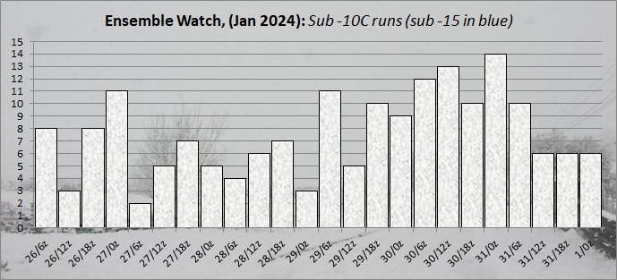
Today's ensemble watch is the coldest set yet.
The upcoming pattern change is a little clearer today. It looks like pressure will rise in the vicinity of the UK at the end of the week, which can only be a good thing for those who are fed up with wind and rain. In the process of doing so, there will be some cold air pushed south, clipping Scotland and then largely passing to the east. This should, however, help to ensure there are some clear skies under the high, leading to widespread frost (as shown on the UK text outlook).
Beyond that the high will decline, as they usually do, but then thanks to the upstream pattern being favourable it'll either be pulled westwards, or a new high will form to the west. This will then pull another pulse of cold air southwards and, at the moment, the ensembles favour that to be a good deal colder than next weekend's effort. It's from this point onwards that the chances of snow begin to rise, moreso if the ridge ends up far enough north and east to engage the exceptionally cold air over Scandinavia.
That's one of the scenarios, anyway. Another scenario is that after next weekend's high declines, the ridging to the west fails to build much, meaning less (or no) cold air is pushed over the UK and we sink back into the status quo. At the moment, though, that's the lesser chance - the majority of the output is showing a colder, more settled interlude on the way. Whether that then extends to a cold spell remains to be seen, but in
the meantime I'm just grateful to see the end of this relentless zonality coming into view.
https://ukwct.org.uk/weather/enswatch.jpg?31
Originally Posted by: Retron