The Weather Outlook

Remove ads from site

UncleAlbert
05 December 2022 14:47:54

Agree and I thunk it could be some time before the ensembles collapse one way or the other. Will be a shame if we have mild southerly muck for Christmas week. 

Originally Posted by: Rob K 

Whilst I agree with this sentiment, I would not be surprised to see only a temporary break up of the wintry spell.

Had a quick look through the GEFS panels, (something I don't often do) and for 264hrs, none of them show the proverbial 'winters over' type scenario.

Quantum
05 December 2022 14:53:21

For much of the Dec 2010 spell, there was scatter in the latter stages. 

Scatter in FI is inevitable.


Originally Posted by: Saint Snow 

Worth pointing out 2010 did have a mild breakdown at the end of the first week.

It was enough to melt the 1-2ft of snow I saw, even though the mild spell only lasted for a couple of days at most.


25/26 (850hpa temp) 11 days snow/sleet falling

18/11 (-4) 19/11 (-6) 20/11 (-6) 01/01 (-7) 04/01 (-10) 10/01 (-7) 11/01 (-3) 30/01 (-1) 13/02 (-6) 15/02 (-4) 18/02 (-6)

24/25 10d

18/11 (-6) 19/11 (-6) 23/11 (-2) 22/12 (-5) 04/01 (-5) 05/01 (0)14/02 (0) 15/02 (0)12/03 (-6) 13/03 (-6)

23/24 8d

29/11 (-6) 30/11 (-6) 02/12 (-5) 03/12 (-5) 04/12 (-3) 16/01 (-3) 18/01 (-8)08/02 (-5)

22/23 7d

18/12 (-1)06/03 (-6) 08/03 (-8) 09/03 (-6) 10/03 (-8) 11/03 (-5) 14/03 (-6)

21/22 12d

Quantum
05 December 2022 14:58:09
UserPostedImage

NHC issued alert for the prospective tropical feature.

This is very important to the development of the weather here over the next few weeks. TCs are very poorly handled by the models, and even though the cliche 'models aren't accounting for strat warming' is very much false, there is some truth in similar logic with TCs. TCs are convective features that cannot be resolved properly by global models, inevitably the track of this feature will be wrong in some respect. And then we have the extratropical transition which will be crucial. Energy will be dumped into the atmosphere by this feature and as a result the jet will intensify. Exactly where the jet stream intensifies will be very important. It could bring the atlantic straight back in, or it could cause a series of cold core lows to form over Europe and swing the winds into the east.


25/26 (850hpa temp) 11 days snow/sleet falling

18/11 (-4) 19/11 (-6) 20/11 (-6) 01/01 (-7) 04/01 (-10) 10/01 (-7) 11/01 (-3) 30/01 (-1) 13/02 (-6) 15/02 (-4) 18/02 (-6)

24/25 10d

18/11 (-6) 19/11 (-6) 23/11 (-2) 22/12 (-5) 04/01 (-5) 05/01 (0)14/02 (0) 15/02 (0)12/03 (-6) 13/03 (-6)

23/24 8d

29/11 (-6) 30/11 (-6) 02/12 (-5) 03/12 (-5) 04/12 (-3) 16/01 (-3) 18/01 (-8)08/02 (-5)

22/23 7d

18/12 (-1)06/03 (-6) 08/03 (-8) 09/03 (-6) 10/03 (-8) 11/03 (-5) 14/03 (-6)

21/22 12d

Quantum
05 December 2022 15:07:55
A few possibilities from the ensembles regarding this tropical feature.

1) Feature remains weak and very little energy dumped. Result: Northerly status quo maintained with UK trough still highly dominant.

UserPostedImage

2)

Energy dumped into the Atlantic NW of the UK. Jet stream rapidly intensifies and zonality is very quickly resumed. High latitude blocking destroyed.

UserPostedImage

3) Energy dumped in the far west of the atlantic. Blocking reorientates towards scandi and cold E/SE winds develop

UserPostedImage

4) Energy dumped quite close to the UK. Blocking partially eroded but not destroyed. Battleground scenario

UserPostedImage

5) Energy dumped to the east of the UK. Remains quite cyclonic but with the potential for some cold easterlies as northern blocking is maintained.

UserPostedImage


25/26 (850hpa temp) 11 days snow/sleet falling

18/11 (-4) 19/11 (-6) 20/11 (-6) 01/01 (-7) 04/01 (-10) 10/01 (-7) 11/01 (-3) 30/01 (-1) 13/02 (-6) 15/02 (-4) 18/02 (-6)

24/25 10d

18/11 (-6) 19/11 (-6) 23/11 (-2) 22/12 (-5) 04/01 (-5) 05/01 (0)14/02 (0) 15/02 (0)12/03 (-6) 13/03 (-6)

23/24 8d

29/11 (-6) 30/11 (-6) 02/12 (-5) 03/12 (-5) 04/12 (-3) 16/01 (-3) 18/01 (-8)08/02 (-5)

22/23 7d

18/12 (-1)06/03 (-6) 08/03 (-8) 09/03 (-6) 10/03 (-8) 11/03 (-5) 14/03 (-6)

21/22 12d

Quantum
05 December 2022 15:16:33
Seems to be a bit of a revrsion towards a stronger UK trough, which is bad for those wishing for an easterly.

UserPostedImage

Very low 500hpa temps though, if this was February or March I think showers would develop in situ over land. But with such a weak sun you have to rely on the lake effect or indeed any frontal features.


25/26 (850hpa temp) 11 days snow/sleet falling

18/11 (-4) 19/11 (-6) 20/11 (-6) 01/01 (-7) 04/01 (-10) 10/01 (-7) 11/01 (-3) 30/01 (-1) 13/02 (-6) 15/02 (-4) 18/02 (-6)

24/25 10d

18/11 (-6) 19/11 (-6) 23/11 (-2) 22/12 (-5) 04/01 (-5) 05/01 (0)14/02 (0) 15/02 (0)12/03 (-6) 13/03 (-6)

23/24 8d

29/11 (-6) 30/11 (-6) 02/12 (-5) 03/12 (-5) 04/12 (-3) 16/01 (-3) 18/01 (-8)08/02 (-5)

22/23 7d

18/12 (-1)06/03 (-6) 08/03 (-8) 09/03 (-6) 10/03 (-8) 11/03 (-5) 14/03 (-6)

21/22 12d

Quantum
05 December 2022 15:19:46
ICON12Z also dumps the energy from the TC further west compared to the 6Z.
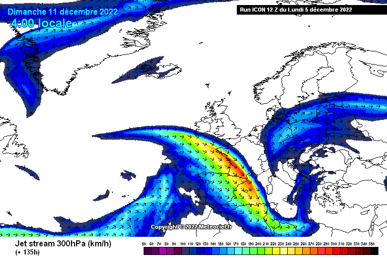
UserPostedImage

You can see the jet stream ramping up close to the UK, so a battleground situ likely later on.

I'd call it a 'big picture' downgrade in terms of overall cold spell maintance. Although at the surface, this could even be an upgrade in terms of cold/snow potential. Keep in mind though, trends in this direction can't go on for long before they cause big damage to the high lat blocking.


25/26 (850hpa temp) 11 days snow/sleet falling

18/11 (-4) 19/11 (-6) 20/11 (-6) 01/01 (-7) 04/01 (-10) 10/01 (-7) 11/01 (-3) 30/01 (-1) 13/02 (-6) 15/02 (-4) 18/02 (-6)

24/25 10d

18/11 (-6) 19/11 (-6) 23/11 (-2) 22/12 (-5) 04/01 (-5) 05/01 (0)14/02 (0) 15/02 (0)12/03 (-6) 13/03 (-6)

23/24 8d

29/11 (-6) 30/11 (-6) 02/12 (-5) 03/12 (-5) 04/12 (-3) 16/01 (-3) 18/01 (-8)08/02 (-5)

22/23 7d

18/12 (-1)06/03 (-6) 08/03 (-8) 09/03 (-6) 10/03 (-8) 11/03 (-5) 14/03 (-6)

21/22 12d

Brian Gaze
05 December 2022 15:46:59

ICON12Z also dumps the energy from the TC further west compared to the 6Z.

UserPostedImage

You can see the jet stream ramping up close to the UK, so a battleground situ likely later on.

I'd call it a 'big picture' downgrade in terms of overall cold spell maintance. Although at the surface, this could even be an upgrade in terms of cold/snow potential. Keep in mind though, trends in this direction can't go on for long before they cause big damage to the high lat blocking.


Originally Posted by: Quantum 


ICON shows the sort of thing a number of op / ens runs have in recent days. I wouldn't read too much into it in isolation.

https://www.theweatheroutlook.com/twodata/icon-global.aspx?run=12&charthour=180&chartname=mslp500&chartregion=na-region&charttag=MSLP%20500hPa 

However, worth noting that ICON did extremely well last Christmas. Another of those cliches you mentioned IMO is "it is only ICON". A lot of the preconceptions about differences in the various models are unsubstantiated nonsense. 


Brian Gaze

Berkhamsted

TWO Buzz - get the latest news and views 

"I'm not socialist, I know that. I don't believe in sharing my money." - Gary Numan

Tim A
05 December 2022 15:52:43
Looking at GFS 12 - It is messy on Thursday with little warmer sectors of air, very complex.  Messy is better than boring and dry though. 
Tim

NW Leeds

187m asl

 My PWS 

warrenb
05 December 2022 16:00:23
I think we need to remember that we are looking for details down to a 50 mile level on what is in affect a global model.
Brian Gaze
05 December 2022 16:03:42
Arpege 12z worth a look from here:

https://www.theweatheroutlook.com/twodata/arpege.aspx?run=12&charthour=60&chartname=ukpreciptype&chartregion=uk-region&charttag=Precip 

The extent of the snow risk is less than GFS shows. 


Brian Gaze

Berkhamsted

TWO Buzz - get the latest news and views 

"I'm not socialist, I know that. I don't believe in sharing my money." - Gary Numan

ballamar
05 December 2022 16:08:37
Let's hope any storms split the northern block and drop a high into Scandi. There is a lot of cold up there to tap into
Quantum
05 December 2022 16:13:54
While ICON is a big picture downgrade, GFS looks like a big picture upgrade. Weaker trough over the UK.


25/26 (850hpa temp) 11 days snow/sleet falling

18/11 (-4) 19/11 (-6) 20/11 (-6) 01/01 (-7) 04/01 (-10) 10/01 (-7) 11/01 (-3) 30/01 (-1) 13/02 (-6) 15/02 (-4) 18/02 (-6)

24/25 10d

18/11 (-6) 19/11 (-6) 23/11 (-2) 22/12 (-5) 04/01 (-5) 05/01 (0)14/02 (0) 15/02 (0)12/03 (-6) 13/03 (-6)

23/24 8d

29/11 (-6) 30/11 (-6) 02/12 (-5) 03/12 (-5) 04/12 (-3) 16/01 (-3) 18/01 (-8)08/02 (-5)

22/23 7d

18/12 (-1)06/03 (-6) 08/03 (-8) 09/03 (-6) 10/03 (-8) 11/03 (-5) 14/03 (-6)

21/22 12d

Whiteout
05 December 2022 16:19:21
7 days away, but talk about battleground possibilities on both UKMO and GFS! Also, getting closer to an Easterly too 😋
Home/Work - Dartmoor

240m/785 ft asl

White Meadows
05 December 2022 16:20:04
Good angle of attack on 12z 

North East is going to do well out of this, but will the enormous scatter and numerous hints to mild breakdown continue after the weekend?...

Brian Gaze
05 December 2022 16:26:48
GFS 12z going for a quicker breakdown attempt than the 6z update.

UserPostedImage


Brian Gaze

Berkhamsted

TWO Buzz - get the latest news and views 

"I'm not socialist, I know that. I don't believe in sharing my money." - Gary Numan

warrenb
05 December 2022 16:29:33
Looking at 216 GFS that is a warm core low to the SW, so in affect a tropical storm. Seems very very unlikely.
Brian Gaze
05 December 2022 16:30:36
Rain to the south of London.

UserPostedImage


Brian Gaze

Berkhamsted

TWO Buzz - get the latest news and views 

"I'm not socialist, I know that. I don't believe in sharing my money." - Gary Numan

Quantum
05 December 2022 16:34:12

Looking at 216 GFS that is a warm core low to the SW, so in affect a tropical storm. Seems very very unlikely.

Originally Posted by: warrenb 

Not all warm cored LPs are TCs. The warm core also has to be deep and symmetrical.

Looks like a warm seclusion to me, i.e an occluded extratropical cyclone.

Did start off as a tropical feature though.


25/26 (850hpa temp) 11 days snow/sleet falling

18/11 (-4) 19/11 (-6) 20/11 (-6) 01/01 (-7) 04/01 (-10) 10/01 (-7) 11/01 (-3) 30/01 (-1) 13/02 (-6) 15/02 (-4) 18/02 (-6)

24/25 10d

18/11 (-6) 19/11 (-6) 23/11 (-2) 22/12 (-5) 04/01 (-5) 05/01 (0)14/02 (0) 15/02 (0)12/03 (-6) 13/03 (-6)

23/24 8d

29/11 (-6) 30/11 (-6) 02/12 (-5) 03/12 (-5) 04/12 (-3) 16/01 (-3) 18/01 (-8)08/02 (-5)

22/23 7d

18/12 (-1)06/03 (-6) 08/03 (-8) 09/03 (-6) 10/03 (-8) 11/03 (-5) 14/03 (-6)

21/22 12d

warrenb
05 December 2022 16:39:02
GFS snow rain snow event.
doctormog
05 December 2022 16:42:46
Again the prolonged cold conditions look like the main story in an otherwise messy picture on this evening's runs so far.
Rob K
05 December 2022 16:51:43
UKMO looks like a very quick breakdown is imminent on the 12z although I haven't seen the 168hr chart. 
Yateley, NE Hampshire, 73m asl

"But who wants to be foretold the weather? It is bad enough when it comes, without our having the misery of knowing about it beforehand." — Jerome K. Jerome

doctormog
05 December 2022 16:57:25

UKMO looks like a very quick breakdown is imminent on the 12z although I haven't seen the 168hr chart. 

Originally Posted by: Rob K 

It looks cold and potentially very snowy:

https://modeles14.meteociel.fr/modeles/ukmo/archives/2022120512/ukmoeu-0-168.png?12 

https://modeles14.meteociel.fr/modeles/ukmo/archives/2022120512/ukmoeu-1-168.png?12  


Brian Gaze
05 December 2022 16:57:34
UK Met 168. 

UserPostedImage


Brian Gaze

Berkhamsted

TWO Buzz - get the latest news and views 

"I'm not socialist, I know that. I don't believe in sharing my money." - Gary Numan

Quantum
05 December 2022 16:58:37
GEM is incredible.

UserPostedImage

It ends with daytime maxima well below freezing for most under deep snow cover.


25/26 (850hpa temp) 11 days snow/sleet falling

18/11 (-4) 19/11 (-6) 20/11 (-6) 01/01 (-7) 04/01 (-10) 10/01 (-7) 11/01 (-3) 30/01 (-1) 13/02 (-6) 15/02 (-4) 18/02 (-6)

24/25 10d

18/11 (-6) 19/11 (-6) 23/11 (-2) 22/12 (-5) 04/01 (-5) 05/01 (0)14/02 (0) 15/02 (0)12/03 (-6) 13/03 (-6)

23/24 8d

29/11 (-6) 30/11 (-6) 02/12 (-5) 03/12 (-5) 04/12 (-3) 16/01 (-3) 18/01 (-8)08/02 (-5)

22/23 7d

18/12 (-1)06/03 (-6) 08/03 (-8) 09/03 (-6) 10/03 (-8) 11/03 (-5) 14/03 (-6)

21/22 12d

Ally Pally Snowman
05 December 2022 16:59:25
GEM is a beauty though looks bitter by day 10.
Bishop's Stortford 85m ASL.

Remove ads from site