The Weather Outlook

Remove ads from site

Windy Willow
16 January 2022 12:03:48

What are the Daily Mirror writers on about? 

UK weather: Sub zero freeze to last all week with -1C chill before snow plume hits


I don't see any signs of a sub zero freeze?

Originally Posted by: briggsy6 

The Express weather foracsters must be on loan 


South Holland, Lincs 5m/16ft ASL

When I saw corruption, I was forced to find truth on my own. I couldn't swallow the hypocrisy.

Barry White

It’s the end of the world as we know it (and I feel fine) - R.E.M.

mulattokid
16 January 2022 12:22:59

I wonder if the Tonga eruption pressure wave will mean a change in the model output.

Originally Posted by: ozone_aurora 


Waves travel 'though' a substance.  They do not push it permananently to a new place, so not sure how that will change anything.

As for the ash. I will not effect weather at this latitude, if at all, for a long time.  It could take months for it to reach our latitude.


Located in West London

"Everything in life is our fault, but that's not our fault!"

Anonymous friend of Quentin Crisp

Bow Echo
16 January 2022 12:53:19


Without a significant literature search if there is indeed any data on the subject, I’d think a sonic pressure wave from an eruption would have as much effect on global weather patterns as a fart would on the ice on your windscreen. Would love to be wrong though 😉 (more conventional methods of clearing screen ice are available)

The dust and ash on the other hand is a completely different story.

Originally Posted by: nsrobins 

Posted this on the Tonga Pressure wave topic, but think it bears posting here as well. Here is the LAST recorded METAR from the Tonga international airport NFTF 150505Z 31009KT 9999 TS FEW009 SCT016CB 28/26 Q1008 RMK VA CLD OVER TBU,RAIN ROCK I have never seen Rain Rock reported before.. I assume it is rain with volcanic ash raining out. Frightning.


Steve D. FRMetS

Burton Latimer, Kettering, Northants


dagspot
16 January 2022 13:20:15
Louise Lear suggesting another 6 days of High Pressure before becoming mobile, wet and windy from west in ‘invigorated jetstream’. Nice.
Neilston 600ft ASL
Gooner
16 January 2022 13:24:47

Louise Lear suggesting another 6 days of High Pressure before becoming mobile, wet and windy from west in ‘invigorated jetstream’. Nice.

Originally Posted by: dagspot 

Where is she getting that from then - I don't see a 168h chart that has the Atlantic at us 


Remember anything after T120 is really Just For Fun


Marcus

Banbury

North Oxfordshire

378 feet A S L


Narnia
16 January 2022 13:47:46
As you quote, anything after T120 is really just for fun. Maybe she is as bored with the weather as I am!!
western100
16 January 2022 14:55:44


Where is she getting that from then - I don't see a 168h chart that has the Atlantic at us 

Originally Posted by: Gooner 

Good model support for HP to be over or near the UK past t168


Worcestershire / Warwickshire Border

100m ASL

X…..@Weather4u2

CField
16 January 2022 15:40:21

Visited the archives of 1895...to see how readily and quick a peach of an easterly set up.Tbh the high just west of UK was very similar to now.What was different was the lows weren't glancing but pushing cold air into  East France central Europe instead of East Balkans Ukraine.We really need low pressure nearer to the UK in whatever form to also bring the Siberian high into play  and things could very  quickly change.Thats my hope.


Favourite snowstorm

Famous channel low

Dec 31st 1978

Hastings East Sussex

Foot of level snow severe drifting

Next day max temp -4 degrees Celsius

Lionel Hutz
16 January 2022 16:03:56


Where is she getting that from then - I don't see a 168h chart that has the Atlantic at us 

Originally Posted by: Gooner 

Meteireann has a similar forecast saying that the High Pressure will slip to the South East bringing in more unsettled conditions. I agree that this doesn't seem to be supported by the charts to my eyes at least.


Lionel Hutz

Nr.Waterford , S E Ireland

68m ASL


idj20
16 January 2022 16:39:55


Where is she getting that from then - I don't see a 168h chart that has the Atlantic at us 

Originally Posted by: Gooner 


I was just thinking that too. While Louise is obviously a well trained and accomplished long-time meteorologist with all the technology and knowledge at her disposal, from where I'm sitting I'm not seeing a crashing return to Atlantic zonality just yet but more of the same high pressure set up for a good week or so - which in itself is pretty remarkable for mid/late January. Obviously she is seeing something that we are not, so I'm sure it'll come out in the wash soon.


Home location: Folkestone Harbour.
Brian Gaze
16 January 2022 16:41:37

Interesting. 


Brian Gaze

Berkhamsted

TWO Buzz - get the latest news and views 

"I'm not socialist, I know that. I don't believe in sharing my money." - Gary Numan

Saint Snow
16 January 2022 16:57:02

As for the ash. I will not effect weather at this latitude, if at all, for a long time.  It could take months for it to reach our latitude.

Originally Posted by: mulattokid 


Just in time to ruin summer 


Martin

Home: St Helens (26m asl) Work: Manchester (75m asl)

A TWO addict since 14/12/01

"How can wealth persuade poverty to use its political freedom to keep wealth in power? Here lies the whole art of Conservative politics."

Aneurin Bevan

mulattokid
16 January 2022 17:00:17


Just in time to ruin summer 

Originally Posted by: Saint Snow 

..Well we were due another good summer. That cannot be allowed to stand 


Located in West London

"Everything in life is our fault, but that's not our fault!"

Anonymous friend of Quentin Crisp

ballamar
16 January 2022 17:50:02
Op run looks a little more interesting than endless high pressure sitting in the wrong place.
doctormog
16 January 2022 17:56:58
The 12z GEFS t850 ensemble mean dips to -11.4°C on Wednesday night here (and I’m not sure it will be evident as anything other than feeling a bit chilly due to the proximity of high pressure).
marting
16 January 2022 18:21:56

The 12z GEFS t850 ensemble mean dips to -11.4°C on Wednesday night here (and I’m not sure it will be evident as anything other than feeling a bit chilly due to the proximity of high pressure).

Originally Posted by: doctormog 

You might scrape a frost out of that 😂 Rather chilly, I would like to have that down here please . Maybe in early feb instead 👍

Martin


Martin

Greasby, Wirral.

tallyho_83
16 January 2022 18:32:12

Just notice the GFS Ensemble 850 uppers are trending colder at day 5/6 (makes a change!) Notice a dip in the upper air temperatures. For instance focus on midday on 20th January 12pm:

Starting from this mornings 06z run: - ENS mean of -2.1c
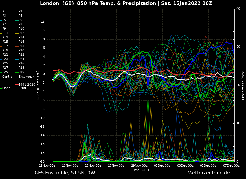
 

This evenings 12z run - ENS mean of -4.0c:
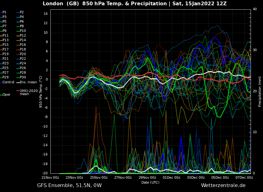
 

Tonight's 18z run: - ENS Mean of -6.4c 
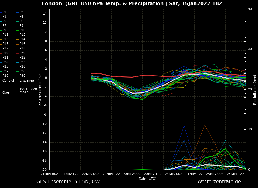
On tonight's 18z there isn't one Ensemble run reaching 850hpa long term mean let alone going above it.

Is something colder brewing in the medium range or am I being too optimistic? ENS rarely trend colder in winter so perhaps we could be in for a surprise but not holding my breath after all the let downs so far this winter esp in December over Christmas time when many models were showing an easterly with snow a few days before and then that record breaking warm NYE/NYD.

What is certain is that some of the runs - esp the Operational are taking the HP further west each run allowing colder air masses in from the north and east...! BUT will this trend continue? Fingers crossed!?

Originally Posted by: tallyho_83 

Looing at the Ensembles the 850 ENS mean for London for 20th January at midday is now down to -7.6c.


Home Location - Vixen Tor Close, Okehampton, Devon (221m ASL)

---------------------------------------

Sean Moon

Magical Moon

www.magical-moon.com

David M Porter
16 January 2022 18:35:25

Interesting that GFS is MUCH colder for Thursday than ICON, ECM, UKMO etc... opening the door to much more of a northerly blast.

Been a crazy winter of uncertainty at relatively short timescales, nevermind extended or FI lol!

Originally Posted by: Gavin P 

Hi Gavin

I made a very similar point in this thread during the week just gone. It has seemed more often than not recently that output for what is normally considered to be the more reliable timeframe has been open to question and subject to change. Even the very mild spell over New Year did not last for as long as the models had originally indicated it might last for.


Lenzie, Glasgow

"A body of men holding themselves accountable to nobody ought not to be trusted by anybody." – Thomas Paine

tallyho_83
16 January 2022 22:43:55


Looking at the Ensembles the 850 ENS mean for London for 20th January at midday is now down to -7.6c.

Originally Posted by: tallyho_83 


The 18z 850s Ensemble mean for London for 20th January at midday is now down to -8.2c.

Upgrades in the shorter timeframe could be the way forward? 🤔 


Home Location - Vixen Tor Close, Okehampton, Devon (221m ASL)

---------------------------------------

Sean Moon

Magical Moon

www.magical-moon.com

ballamar
16 January 2022 22:57:36
Op looks like thing changing about 10 days blocking could be more favourable
ballamar
16 January 2022 23:04:57
www.wetterzentrale.de/maps/GFSOPEU18_336_1.png

One run ages away but close to a decent cold spell

BJBlake
17 January 2022 05:48:06

A sobering bore-fest morning GFS Op, after a great night out at the pub (run)...brings the Atlantic back in FI after a northern jet shoot-out. We may get a cold blast down the east coast, but this is only a flirt from other models and blink and its gone, before the fat toppled high squishes it and pushes it in to Eastern Europe. 


Brecklands, South Norfolk 28m ASL
DEW
  • DEW
  • Advanced Member
17 January 2022 06:57:47

Summary charts like yeterday and the day before, cold air across N Europe and separately across the Alps,not as cold in between more emphasis on S branch today. pptn N Atlantic and in the Med

GFS 0z - HP over or close to Uk for rest of Jan, occasional Nly plunges just missing E coast eg Thu 20th Sun 30th; zonal W-lies for start of Feb

GEFS - agreement on brief cold spell Thu 20th, mean soon reverts to norm and later on a little below, not much agreement between ens members after Thu 27th (significant number of colder members in the mix) Very dry, a bit of rain Feb 1st/2nd

ECM -  Like GFS but Hp somewhat further S from Min 24th with more W-ly influence


I can calculate the movements of stars, but not the madness of men - Isaac Newton

Chichester 12m asl

TPentlow
17 January 2022 07:10:58
If anyone is looking to see an interesting chart this morning the CFS is looking good for February. Builds a strong scandi high with a low over Europe.
________________________________________________

Tom (North Northants - 130m asl)

ballamar
17 January 2022 08:13:21
Not looking positive for cold today! Oh well the bore fest high has still been noteworthy

Remove ads from site