Remove ads from site
Cold dry extension looks on the cards... with a good chance of an even colder blast in ten days
Originally Posted by: squish
So looks as if the SW will miss out or too early to say?
---------------------------------------
Sean Moon
Magical Moon
www.magical-moon.com
Incredible run for here with heavy snow tomorrow easing to snow showers until Wednesday. A day for recovery and dig ourselves out on Thursday before a freezing rain turning to snow event on Friday. The cold eases back west with us remaining in the freezer next weekend as we look east for a stronger potential beast next week.
Its the sort of thing that as a kid I would draw make believe weather charts of !
Current conditions from my Davis Vantage Vue
https://www.wunderground.com/dashboard/pws/IFOLKE11
Join Kent Weather on Facebook.
https://www.facebook.com/stevewall69/
Originally Posted by: Gusty
Normally I would dismiss it but it seems plausible. If the 12z output shows anything similar, it will be...interesting.
Current conditions (personal WS)
Do we really think that huge swathe of England surrounding the Humber will be completely devoid of snow?
I would be genuinely surprised.
Originally Posted by: Joe Bloggs
That’s made me very wary of what might come in the next few days and I’m careful what I wish for. I’ll report my snow depth if we get any.
Join the fun and banter of the monthly CET competition.
Windchill next weekend
Marcus
Banbury
North Oxfordshire
378 feet A S L
At +180 the GFS ENS has some colder options but nothing as dramatic as the Op. P10 looks promising but most don't back the Op, with HP further south and less intense in many cases. Still, the Op has swung so others could follow.
Retire while you can still press the 'retire now' button.
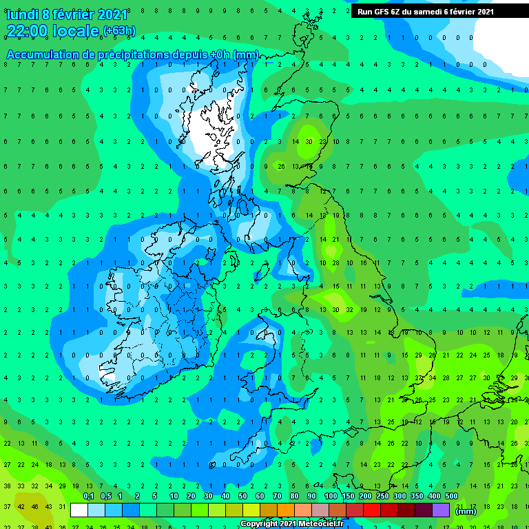
25mm accumulated rainfall is a foot of snow in my book.
Some of this starts as rain.
No reason to dispute this will be a general 20cm + even on most low ground from this event. Excluding drifting.
Originally Posted by: Bertwhistle
Are they out to 180hr yet?
This weekends /weeks snow could hang around for a bit
Originally Posted by: Gooner
Also spot the next cold plunge over North America. Negative 850's into northern Florida. Possibly a true battle ground building there?
Well if that is right , I would be content
http://www.weersite.net/?actueel&ensemble&ecmwfpluim
Originally Posted by: doctormog
No - unless there’s a rapid source I don’t know about.
Fareham, Hampshire 28m ASL (near estuary)
Stormchaser, Member TORRO
Bolton, Lancashire
160m asl
Snow videos:
http://www.youtube.com/channel/UC3QvmL4UWBmHFMKWiwYm_gg
The Control has a snowy Thursday also
Gfs a little ahead of its self but going to plan
id put my next move on intense area moving to to S west Iceland
I’d say a Scadi victory then high moving west yes west into Scotland that’s a huge wall of cold not easy for that low to get in to shift it looks like it’s getting smashed to bits even with one of gfs power bombs we shall see
spreads are also huge on that low
http://www.meteociel.fr/cartes_obs/gens_panel.php?modele=0&mode=1&ech=144
quote=Gooner;1314000]
Where's your money with that lot
Originally Posted by: Polar Low
You will do very well out of this mate.
Hmmm- maybe I should have another look.
Edit- seems they weren't. I might have been looking at 150. Luckily everybody else on here is too tuned in to have paid heed to a moment of near gloom.
Apologies.
Some shift!!
Yes the ensembles for the next week at least look very good. This is the t850hPa one for here.
Some crazy temps on the OP by 14th. Widely -4c by day.