The Weather Outlook

Remove ads from site

tallyho_83
09 January 2021 17:48:11


Is wintry hazards a new winter buzzword? 

Originally Posted by: Heavy Weather 2013 

It Must be!

Met Office have been using this for a while now - Only been in their forecast this winter - I wonder where the "Winter Terminology that get's on your nerves" thread is!? 

Wintry Hazards could mean fog, ice, snow, frost, sleet, hail...the list goes on...and another thing that get's on my nerves is their over use of "Wintry showers!" what is the definition of a wintry shower? Again this could mean rain, hail, sleet or snow - even worse they say showers turning wintry' - when they could say rain showers turning to sleet or snow. It's as if they are too lazy to explain it in detail or are doing it to cover their backsides. As for "wintry hazards' accidents caused by cars slipping on ice or frost is a wintry hazard as is walking and slipping on ice - that's a wintry hazard too. 

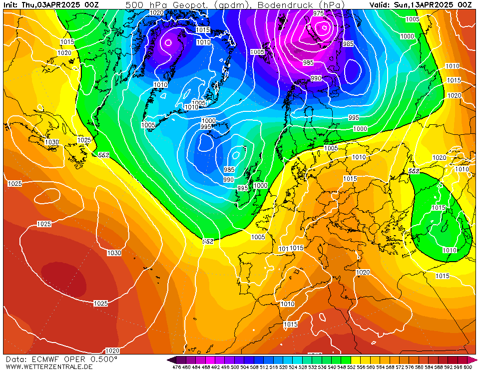
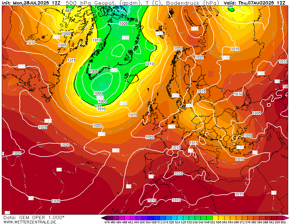
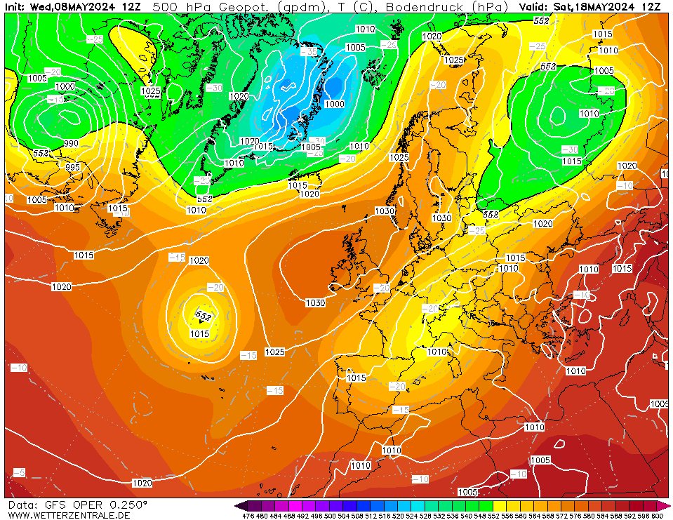
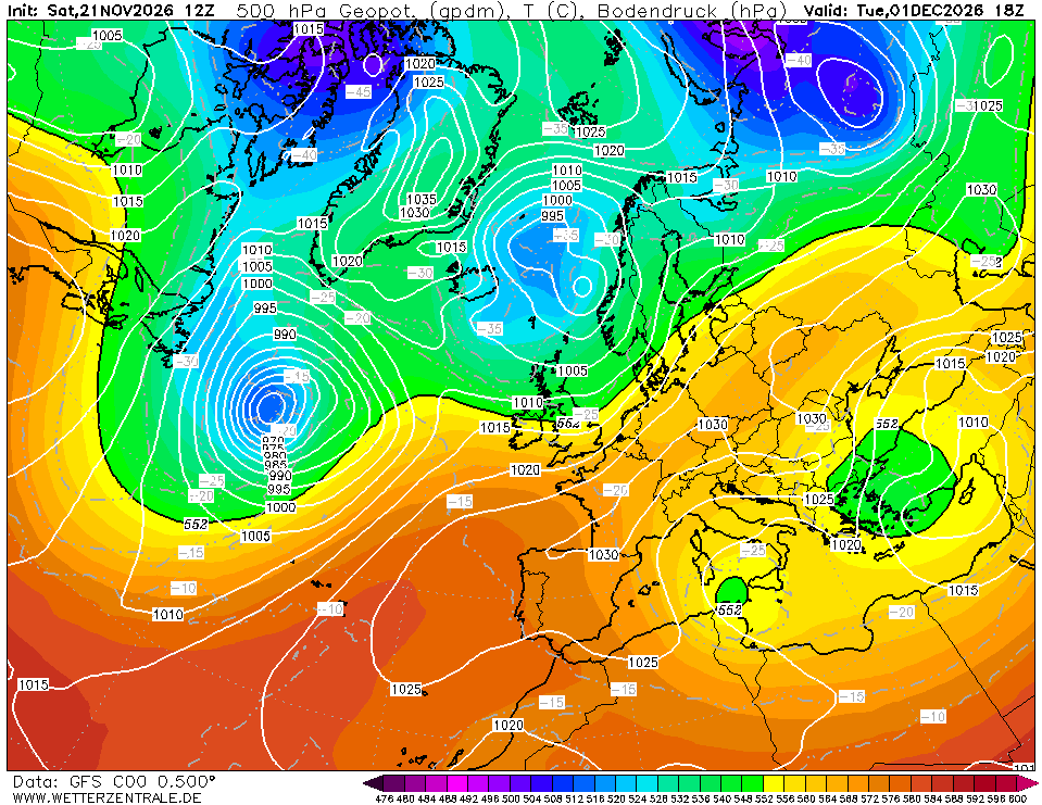
Back to models - Some cross model agreement at +240/252:

ECM: - Northerly Plunge:
GEM: - Northerly Plunge:
Op - Northerly Plunge:
Control = Northerly plunge:

Home Location - Vixen Tor Close, Okehampton, Devon (221m ASL)

---------------------------------------

Sean Moon

Magical Moon

www.magical-moon.com

tallyho_83
09 January 2021 18:24:03

Looking at 12z ENS for Aberdeen - many ENS members going below the -10c isotherm and the Operational goes from being one of the colder ENS members to one of the milder ones at end - all FI of course but one to watch:


Home Location - Vixen Tor Close, Okehampton, Devon (221m ASL)

---------------------------------------

Sean Moon

Magical Moon

www.magical-moon.com

Quantum
09 January 2021 18:35:16

I think a below average January CET is pretty much guaranteed at this point.


25/26 (850hpa temp) 11 days snow/sleet falling

18/11 (-4) 19/11 (-6) 20/11 (-6) 01/01 (-7) 04/01 (-10) 10/01 (-7) 11/01 (-3) 30/01 (-1) 13/02 (-6) 15/02 (-4) 18/02 (-6)

24/25 10d

18/11 (-6) 19/11 (-6) 23/11 (-2) 22/12 (-5) 04/01 (-5) 05/01 (0)14/02 (0) 15/02 (0)12/03 (-6) 13/03 (-6)

23/24 8d

29/11 (-6) 30/11 (-6) 02/12 (-5) 03/12 (-5) 04/12 (-3) 16/01 (-3) 18/01 (-8)08/02 (-5)

22/23 7d

18/12 (-1)06/03 (-6) 08/03 (-8) 09/03 (-6) 10/03 (-8) 11/03 (-5) 14/03 (-6)

21/22 12d

tallyho_83
09 January 2021 18:57:05


It Must be!

Met Office have been using this for a while now - Only been in their forecast this winter - I wonder where the "Winter Terminology that get's on your nerves" thread is!? 

Wintry Hazards could mean fog, ice, snow, frost, sleet, hail...the list goes on...and another thing that get's on my nerves is their over use of "Wintry showers!" what is the definition of a wintry shower? Again this could mean rain, hail, sleet or snow - even worse they say showers turning wintry' - when they could say rain showers turning to sleet or snow. It's as if they are too lazy to explain it in detail or are doing it to cover their backsides. As for "wintry hazards' accidents caused by cars slipping on ice or frost is a wintry hazard as is walking and slipping on ice - that's a wintry hazard too. 

Back to models - Some cross model agreement at +240/252:

ECM: - Northerly Plunge:

GEM: - Northerly Plunge:

Op - Northerly Plunge:

Control = Northerly plunge:

Originally Posted by: tallyho_83 

ECM @ 240 - Northerly Plunge

Whether or not this is the Trop response to the SSW is unknown? But there is good X model agreement for next weekend to be cold.


Home Location - Vixen Tor Close, Okehampton, Devon (221m ASL)

---------------------------------------

Sean Moon

Magical Moon

www.magical-moon.com

Rob K
09 January 2021 18:59:48
Incredible uncertainty on the GFS at short range. The max 2m temperature for a random spot in England on Tuesday - just three days away - varies from 3C to 10C between runs.

http://www.meteociel.fr/modeles/gefs_table.php?x=287&y=148&run=12&ext=fr&mode=7&sort=0 


Yateley, NE Hampshire, 73m asl

"But who wants to be foretold the weather? It is bad enough when it comes, without our having the misery of knowing about it beforehand." — Jerome K. Jerome

Arbroath 1320
09 January 2021 19:01:08

ECM 12z = Azores high domination. Drifts a bit further North as the run progresses and hints of a potential hook up with heights to our NE in deep FI.

Based on that run, a quiet spell of weather coming up, dryish with average to cool temperatures.


Kenmore, Highland Perthshire, GGTTH
Ally Pally Snowman
09 January 2021 19:03:01

ECM gets to a decent position eventually by day 9/10. The difference this time is we have lots of cold air to our east. A cold spell starting about 18th is a good bet at the moment. 


Bishop's Stortford 85m ASL.
Hippydave
09 January 2021 19:07:07

Hmmm.

ECM is pretty meh for most of the run although it teases with its T240 chart. 

The London GFS ens are very scattered mid term with a fair few rain spikes suggesting usual alternating mild/cool as LPs move through and it's only deep in FI that we get some proper cold in. (Further North the ens look more encouraging)

All in all unless something changes I'll keep my excitement levels at zero for down here. The GFS ens may have reasonable agreement for the broad pattern but when you see how different the ECM and GFS ops are it says 'no clue' to me and given a lot of the GFS colder options rely on Greenie blocking which hasn't come off despite it being modelled a lot, I think I'll err on the pessimism side 


Home: Tunbridge Wells

Work: Tonbridge

White Meadows
09 January 2021 19:19:51

The big three in such a mess at the moment.


Anyone trying to figure a dominant weather type by this point next week will be using a large slice of guesswork.

UncleAlbert
09 January 2021 19:40:59

The big three in such a mess at the moment.


Anyone trying to figure a dominant weather type by this point next week will be using a large slice of guesswork.

Originally Posted by: White Meadows 

WAA towards Greenland around 216-240hrs is a common theme though. ECM looks a better bet for a more potent UK wide cold spell in my eyes.  The main thrust of the ridge takes it in the Scandy direction.  A much better bet than the GFS push which ends up too far West.

DPower
09 January 2021 19:44:06

No consistency from the Euro models at all in the last couple of days. The SSW seems to really have shaken things up. I personally would ignore the ecm run tonight t144 onwards looks a complete mess. No Arctic high or HLB's past t168. Regardless of weather the UK gets to see deep cold or not you would expect to see the SSW signature imprinted over the arctic.

Ally Pally Snowman
09 January 2021 19:54:07

ECM mean cold by day 10. Looks very good.

https://www.wetterzentrale.de/topkarten.php?map=1&model=ecm&var=1&run=12&time=240&lid=AVG&h=0&mv=0&tr=24#mapref


Bishop's Stortford 85m ASL.
Russwirral
09 January 2021 20:07:07
Ecm not a million miles away from very very cold air spilling east from scandinavia

Looks an awful like that link someone posted earlier about that weather man forecast dispute in 2001 with helen young


marting
09 January 2021 20:12:11
White Meadows
09 January 2021 20:51:10

ECM has a rogue run or so giving a -17c in Manchester circa 21st. Op on high side tonight. Colder runs overall

https://www.ecmwf.int/en/forecasts/charts/web/classical_meteogram?facets=undefined&time=2021010912,0,2021010912&epsgram=classical_15d&lat=53.4809&lon=-2.23743&station_name=Manchester,%20United%20Kingdom&altitude=60

Matin

Originally Posted by: marting 

We’ve been here before though, only a few days before Christmas... and then major downgrades followed.

I think the SSW as usual is either going to make some very happy or very angry mob descend in a couple of weeks time. 

Jeff
  • Jeff
  • Advanced Member
09 January 2021 20:58:40

Incredible uncertainty on the GFS at short range. The max 2m temperature for a random spot in England on Tuesday - just three days away - varies from 3C to 10C between runs.

http://www.meteociel.fr/modeles/gefs_table.php?x=287&y=148&run=12&ext=fr&mode=7&sort=0

Originally Posted by: Rob K 

Meanwhile, I think the longer term (at 10 days) pattern is becoming clear. The following are the last three GFS suites SLP average at 10 days

00h

https://www.wetterzentrale.de/de/topkarten.php?map=1&model=gfs&var=1&time=252&run=00&lid=AVG&h=0&tr=6&mv=0#mapref

06h

https://www.wetterzentrale.de/de/topkarten.php?map=1&model=gfs&var=1&time=246&run=6&lid=AVG&h=0&mv=0&tr=6

12h

https://www.wetterzentrale.de/de/topkarten.php?map=1&model=gfs&var=1&time=240&run=12&lid=AVG&h=0&tr=6&mv=0#mapref

You can do the same with the 850s.

Jeff


On the East/West Sussex Border

70m ASL

Shropshire
09 January 2021 21:33:09


Meanwhile, I think the longer term (at 10 days) pattern is becoming clear. The following are the last three GFS suites SLP average at 10 days

00h

https://www.wetterzentrale.de/de/topkarten.php?map=1&model=gfs&var=1&time=252&run=00&lid=AVG&h=0&tr=6&mv=0#mapref

06h

https://www.wetterzentrale.de/de/topkarten.php?map=1&model=gfs&var=1&time=246&run=6&lid=AVG&h=0&mv=0&tr=6

12h

https://www.wetterzentrale.de/de/topkarten.php?map=1&model=gfs&var=1&time=240&run=12&lid=AVG&h=0&tr=6&mv=0#mapref

You can do the same with the 850s.

Jeff

Originally Posted by: Jeff 

Yes it's a clear trend - the SSW is in play and a cold plunge into Europe is the way we look to be headed - not the Scandi blocking that could have been on the cards. So we are looking at being on the edge of the cold and the uncertainty that that will bring, fascinating model watching coming up.


From December 27th 2020, zonality will be banned from mixing with the UK. We appreciate that this may come as a shock to younger people and old Uncle Barty. This ban will last for a minimum of ten days.
Gooner
09 January 2021 21:43:21

I feel this chase has gone for weeks and weeks lol , I still don't see us being any closer if I'm honest.

We have had a 2 week spell of below average temps , we would be very very lucky to experience that again this Winter 


Remember anything after T120 is really Just For Fun


Marcus

Banbury

North Oxfordshire

378 feet A S L


doctormog
09 January 2021 21:46:49
What are the chances of a cold blast from a northerly quarter at around day 10 on this GFS op run, or the GFSP or indeed both. I wouldn’t bet on another run with sub 510dam air here again though!
jhall
09 January 2021 21:56:28

I feel this chase has gone for weeks and weeks lol , I still don't see us being any closer if I'm honest.

We have had a 2 week spell of below average temps , we would be very very lucky to experience that again this Winter 

Originally Posted by: Gooner 

I would have thought that, if anything, one cold spell would make a second more likely rather than less. It's certainly happened in the past: 1981-2, 1985, 2009-10 and - if you include March as part of winter - 2013.


Cranleigh, Surrey
western100
09 January 2021 22:09:14
The severity of this 2 week cold spell has been understated. CET has ran under 1 degree for 2 weeks. That’s not common in any winter, let alone winters of nowadays. Snow was not great but if your comparing this cold spell on temperatures then it’s not been a bad one

If anything we will end up with December under 5 degree and a below average January. Rarity for a few years

I am flicking through 18z so far and I wonder what will venture post 144?


Worcestershire / Warwickshire Border

100m ASL

X…..@Weather4u2

Sasa
  • Sasa
  • Advanced Member
09 January 2021 22:22:07
I have hardly seen a flake form the current cold spell. Today was the best day. Cold +2c and clear blue skies and with no wind. Major feature!

The forthcoming cold spell is different as for the first time this winter (and majority of last winter) it is going to bring average temperatures to Eastern Europe and even lower which was absent to date, therefore any easterly which develops will have a cold pool to tap into.

Lets see what the pub run brings but there are some interesting scenarios on offer.


Kingston Upon Thames
Downpour
09 January 2021 22:29:52


It Must be!

Met Office have been using this for a while now - Only been in their forecast this winter - I wonder where the "Winter Terminology that get's on your nerves" thread is!? 

Wintry Hazards could mean fog, ice, snow, frost, sleet, hail...the list goes on...and another thing that get's on my nerves is their over use of "Wintry showers!" what is the definition of a wintry shower? Again this could mean rain, hail, sleet or snow - even worse they say showers turning wintry' - when they could say rain showers turning to sleet or snow. It's as if they are too lazy to explain it in detail or are doing it to cover their backsides. As for "wintry hazards' accidents caused by cars slipping on ice or frost is a wintry hazard as is walking and slipping on ice - that's a wintry hazard too. 

Back to models - Some cross model agreement at +240/252:

ECM: - Northerly Plunge:

GEM: - Northerly Plunge:

Op - Northerly Plunge:

Control = Northerly plunge:

Originally Posted by: tallyho_83 


I have just encountered a wintry hazard: the icy steps in my back garden. Legs flailing. Very nearly ended up on my backside.

Another accurate forecast from the much maligned Office.


Chingford

London E4

147ft

Arbroath 1320
09 January 2021 22:43:13

GFS pub run goes for something completely different. It drops the Mid-atlantic high idea and tries a failed attempt at a Scandi. Then goes on to form a decent Greenland High but it's too far West for the UK to benefit.

One for the bin I think.


Kenmore, Highland Perthshire, GGTTH
Brian Gaze
09 January 2021 22:43:20
Marco Petagna on Twitter suggesting La Nina may overwride the impact of the SSW. Not sure if that's what the Met O models are favouring.
Brian Gaze

Berkhamsted

TWO Buzz - get the latest news and views 

"I'm not socialist, I know that. I don't believe in sharing my money." - Gary Numan

Remove ads from site