The Weather Outlook

Remove ads from site

doctormog
09 January 2021 22:45:05

GFS pub run goes for something completely different. It drops the Mid-atlantic high idea and tries a failed attempt at a Scandi. Then goes on to form a decent Greenland High but it's too far West for the UK to benefit.

One for the bin I think.

Originally Posted by: Arbroath 1320 

It looks pretty cold in northern parts and continues the trend with very cold air edging this way from Scandinavia to one extent or another.


Arbroath 1320
09 January 2021 22:47:21

Marco Petagna on Twitter suggesting La Nina may overwride the impact of the SSW. Not sure if that's what the Met O models are favouring.

Originally Posted by: Brian Gaze 

Certainly looking for sustained cold seems like chasing rainbows at present Brian. Nothing concrete in the MO, and the ENS are scattered all over the place.


Kenmore, Highland Perthshire, GGTTH
western100
09 January 2021 22:51:02
The 18z is vastly different after 144 vs 12z. The trend remains the same to build pressure in the Atlantic / Greenland and for the scandi high to form to then be replaced by deeper cold from the East

The impact on us remains unclear


Worcestershire / Warwickshire Border

100m ASL

X…..@Weather4u2

marting
09 January 2021 22:51:08

Marco Petagna on Twitter suggesting La Nina may overwride the impact of the SSW. Not sure if that's what the Met O models are favouring.

Originally Posted by: Brian Gaze 

Appears to be playing with words as he suggests the La Niña impact will be felt late winter, not in this part of winter, suggests to me cold coming through for next month at least. That’s what the models trends are showing to me.

Martin


Martin

Greasby, Wirral.

Arbroath 1320
09 January 2021 22:52:12


It looks pretty cold in northern parts and continues the trend with very cold air edging this way from Scandinavia to one extent or another.

Originally Posted by: doctormog 

Yes, cold air is never far away from Scotland and in some runs it is slap bang over us. All seems a bit marginal, but the potential for cold is certainly there.


Kenmore, Highland Perthshire, GGTTH
doctormog
09 January 2021 22:53:43


Yes, cold air is never far away from Scotland and in some runs it is slap bang over us. All seems a bit marginal, but the potential for cold is certainly there.

Originally Posted by: Arbroath 1320 

You can say that again...


western100
09 January 2021 22:55:58


You can say that again...


Originally Posted by: doctormog 


on these runs tonight, the boundary line sits somewhere in the northern part of the UK. For the North that would be interesting 


Worcestershire / Warwickshire Border

100m ASL

X…..@Weather4u2

Gooner
09 January 2021 22:59:10


Certainly looking for sustained cold seems like chasing rainbows at present Brian. Nothing concrete in the MO, and the ENS are scattered all over the place.


Originally Posted by: Arbroath 1320 

This is the feeling I am getting unfortunately 


Remember anything after T120 is really Just For Fun


Marcus

Banbury

North Oxfordshire

378 feet A S L


fairweather
09 January 2021 23:00:08

GFS pub run goes for something completely different. It drops the Mid-atlantic high idea and tries a failed attempt at a Scandi. Then goes on to form a decent Greenland High but it's too far West for the UK to benefit.

One for the bin I think.

Originally Posted by: Arbroath 1320 

Definitely for the South. Brief hope then westerlies all the way. Bin job. Next please!


S.Essex, 42m ASL
White Meadows
09 January 2021 23:03:51

Marco Petagna on Twitter suggesting La Nina may overwride the impact of the SSW. Not sure if that's what the Met O models are favouring.

Originally Posted by: Brian Gaze 

Does that mean La Niña overriding the mild impact of SSW... meaning a cold outcome? You can’t have it both ways. 

doctormog
09 January 2021 23:05:56

A seriously impressive run for northern parts. One of a range of options no doubt, but it trumps any ESEly muck here any day. Should be some good ensemble members again.


Russwirral
09 January 2021 23:39:12
I do get the feeling something is building... a good chance its SSw related.

Each run looks a little more easterly or extent of LPs heading north - supressed

Wouldnt be surprised if we see fire works on this thread tomorrow with cold within the 144 range and the UK accelerating towards cold weather again... it just has that calm before the storm feel about it

Weve been here before, i dont think it will be as long as the charts are representing things today.


tallyho_83
09 January 2021 23:44:15

Does that mean La Niña overriding the mild impact of SSW... meaning a cold outcome? You can’t have it both ways. 

Originally Posted by: White Meadows 

Let's hope mild - but at any rate it's all here say'. I mean we had a SSW during winter 2017/18 and that was a La Nina winter and we still got the blocking and BFTE.


Home Location - Vixen Tor Close, Okehampton, Devon (221m ASL)

---------------------------------------

Sean Moon

Magical Moon

www.magical-moon.com

tallyho_83
09 January 2021 23:49:28

ENS so far mean for Aberdeen on 21st January is -7.3c uppers when the 12z run had an ENS mean of -5c so the ENS have trended colder - is this a theme? Maybe but again my worry is that the south will miss out YET AGAIN. But more runs needed as always:

How patient can we be and how long do we need to wait?


Home Location - Vixen Tor Close, Okehampton, Devon (221m ASL)

---------------------------------------

Sean Moon

Magical Moon

www.magical-moon.com

tallyho_83
09 January 2021 23:55:36

Looking at 18z GFS ENS for London - looks like the Operational is one of the milder runs from 17th but many more colder ENS sub -10 uppers are appearing! A lot of scatter now. I think we are in for a roller-coaster!? 


Home Location - Vixen Tor Close, Okehampton, Devon (221m ASL)

---------------------------------------

Sean Moon

Magical Moon

www.magical-moon.com

tallyho_83
10 January 2021 00:11:48

On another note - although it is +384z away:

PS - IF this came off then let's hope it's the right type of SSW and at any rate it would the first time we have seen two SSW in one winter "IF" this came off: - Looking at AO/NAO which remain negative and strength of zonal winds it appears that there could well be another SSW could be on the cards:


Home Location - Vixen Tor Close, Okehampton, Devon (221m ASL)

---------------------------------------

Sean Moon

Magical Moon

www.magical-moon.com

Gooner
10 January 2021 00:56:26

Chart image

This looks an improvement , but god it's a long long wait 


Remember anything after T120 is really Just For Fun


Marcus

Banbury

North Oxfordshire

378 feet A S L


Matty H
10 January 2021 01:16:55

Long wait? It’s less than a week if it even happened. Quantum says GFS is useless so I’m not even sure why anyone even bothers to view it, let alone comment on it........


Chart image

This looks an improvement , but god it's a long long wait 

Originally Posted by: Gooner 


Yate, Nr Bristol

TBFTEIARBSC

fairweather
10 January 2021 01:21:07

Chart image

This looks an improvement , but god it's a long long wait 

Originally Posted by: Gooner 

Bit of a downward trend emerging to the 21st but no strong signals emerging for cold. Lots of westerly in there and not very inspiring really.

I would prefer a short sharp shock before winter is out. A proper blizzard like we haven't had since the 80's, even if it is only cold for 3-4 days.


S.Essex, 42m ASL
Retron
10 January 2021 06:52:09

Another day, another coldest set of GEFS of the winter so far.

Here's this morning's ensemble watch, click for full-size:
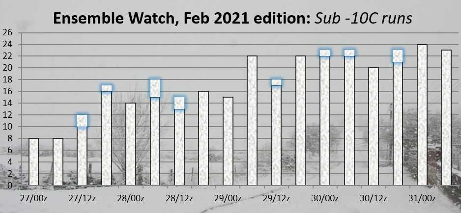
(FWIW, 9 of the 11 runs above have had the onset of the potential cold as the 18th-20th. It's been remarkably consistent there!)


Leysdown, north Kent
Whether Idle
10 January 2021 07:03:11

Another day, another coldest set of GEFS of the winter so far.

Here's this morning's ensemble watch, click for full-size:

(FWIW, 9 of the 11 runs above have had the onset of the potential cold as the 18th-20th. It's been remarkably consistent there!)

Originally Posted by: Retron 

Thanks for the ensemble watch Darren.  I can see the potential is there but remain fairly skeptical that deep cold will be delivered widely to our shores.  Im happy to sit back and watch.  Fascinating model watching if ever there was a period for the hobbyist model watcher, this is it!


Dover, 5m asl. Half a mile from the south coast.
Ally Pally Snowman
10 January 2021 07:05:29

Poor ECM this morning it blows away the HLB by day 10. Very different to last night's Mean . Hopefully a massive outlier. 


Bishop's Stortford 85m ASL.
Retron
10 January 2021 07:07:57

NB - I suspect one of the reasons we're seeing the number of very cold members increase of late in GEFS is that the SSW situation is subtly changing. Instead of one long burst, we're now coming to the end of a first reversal. A couple of days later a second reversal starts and goes on out to day 10:

https://www.geo.fu-berlin.de/en/met/ag/strat/produkte/winterdiagnostics/index.html

In addition, another reversal at 1hPa shows up right at the end... this is very unusual! It remains to be seen whether that, like the previous reversal right at the top, works its way down. If it does all bets are off (even moreso than of late).

I also remember on usw ages ago a suggestion that the sort of thing we have now, i.e. a 10hPa reversal followed by a weak resumption of westerlies aloft helps "push down" the easterlies that bit faster. To then be followed by another reversal would suggest those easterlies, once pushed down, would remain there for quite some time.

We'll see, anyway, if nothing else it's fascinating chart-watching!


Leysdown, north Kent
Ally Pally Snowman
10 January 2021 07:24:12

For what it's worth the automated BBC forecast is looking cold and snowy from the 19th.

Really hoping the ECM is an outlier as it's such a stinker. Was not expecting that this morning. Other output is steady. 


Bishop's Stortford 85m ASL.
DEW
  • DEW
  • Advanced Member
10 January 2021 08:03:34

Jetstream - the main flow dipping well south as it comes out of the US and resuming strongly across the Med/N Africa. In the middle there are weaker and often fragmented streaks, more often than not favouring the UK with a branch running down from the NW. Pattern changes at end of run Sat 23rd - Tue 26th with a powerful loop which develops to encircle the UK while a more connected stream resumes to the S.

GFS - LPs running across N of UK and then down through C Europe until Wed 20th when HP previously to S of UK retrogresses and forms ridge in mid Atlantic. This allows N/NE-lies over UK with local LP e.g. Brittany 995mb that Wed. HP then moves back to form a definite centre over UK 1035mb Mon 25th.

GEFS - after a day or two mild and damp later his week, mean of temps resumes a few degrees below seasonal norm (coldest around Thu 21st esp Scotland) through to Tue 26th but with much variation in individual runs implying low confidence after about Wed 20th (probably depends on where the HP referred to above sets up - a little further E for mild, a little further W for cold) Some very extreme runs esp on the cold side. Rain/snow in varying amounts throughout, according to which run you look at.

ECM - similar pattern to GFS but keeps the HP closer to the UK and the LP near Scandi further E so does not develop more than a trickle of N/NE lies around the 20th


I can calculate the movements of stars, but not the madness of men - Isaac Newton

Chichester 12m asl

Remove ads from site