DEW
  • DEW
  • Advanced Member
14 January 2020 07:16:31

GFS as yesterday shows storm Brendan declining over the week, though FAX shows more of a sting in the tail especially for the south than do GFS synoptics. High pressure then established to the SW for the whole of the following week, a little weaker after that with the possibility of northerlies blowing down the N Sea on Wed 29th. ECM similar but hinting at northerlies earlier.


Dry after 17th until some uncertain stuff after 25th. Temps in S below normal in all runs to 21st, then most runs a degree or two above seasonal average but declining to the 27th  according to GEFS. In Scotland & N England, warms up earlier ca 18th.


War does not determine who is right, only who is left - Bertrand Russell

Chichester 12m asl
Ally Pally Snowman
14 January 2020 07:28:29

A couple of sunny crisp days then back to mild crud it would seem. The worst and most boring winter of the internet era continues. 


Bishop's Stortford 85m ASL.
tallyho_83
14 January 2020 10:34:36

Originally Posted by: Ally Pally Snowman 


A couple of sunny crisp days then back to mild crud it would seem. The worst and most boring winter of the internet era continues. 


Then looks at 00z GFS and see's a block and northerly come the end - giving a us some hope - yet only to find that it is - YET AGAIN a cold outlier - the OP run:


Home Location - Kellands Lane, Okehampton, Devon (200m ASL)
---------------------------------------
Sean Moon
Magical Moon
www.magical-moon.com


Gusty
14 January 2020 10:42:15

Very likely that the high pressure will settle close to our SW next week.


Sadly there is a warm front arriving late Sunday (boundary between the green and yellow) that will soon turn it into a cloudy and increasingly mild borefest High.


Steve - Folkestone, Kent
Current conditions from my Davis Vantage Vue
https://www.wunderground.com/dashboard/pws/IFOLKE11 
Join Kent Weather on Facebook.
https://www.facebook.com/stevewall69/ 


Rob K
14 January 2020 11:00:39
I still think there's a good chance we will see some notably cold air coming over the UK at some point in the next month or so. There is some very intense cold pooling not all that far to our north so it wouldn't take much for the floodgates to open.
Yateley, NE Hampshire, 73m asl
"But who wants to be foretold the weather? It is bad enough when it comes, without our having the misery of knowing about it beforehand." — Jerome K. Jerome
Phil G
14 January 2020 11:35:26

Originally Posted by: Rob K 

I still think there's a good chance we will see some notably cold air coming over the UK at some point in the next month or so. There is some very intense cold pooling not all that far to our north so it wouldn't take much for the floodgates to open.


At times there is potential, only to be scuppered by low pressure or the 'wrong' shape of high pressure moving through and deflecting any notable northerly outbreaks. We still live in hope though!


Perhaps I am getting older, but this must be the least amount of time I have spent looking at charts during Winter for a good 25 years now.

Arbroath 1320
14 January 2020 11:54:17

Originally Posted by: Phil G 


At times there is potential, only to be scuppered by low pressure or the 'wrong' shape of high pressure moving through and deflecting any notable northerly outbreaks. We still live in hope though!


Perhaps I am getting older, but this must be the least amount of time I have spent looking at charts during Winter for a good 25 years now.


Snap. Just looking fleetingly at the charts this Winter. When you get such a monster Azores High early on in the Winter it will always take some shifting, particularly when it's aided and abetted by it 's cousin the Euroslug.


I think the best we can hope for in the remaining Winter months is some occasional frosty weather during periods when pressure builds enough from the South to sit over us.


GGTTH
Weathermac
14 January 2020 12:33:23
The borefest winter continues just when it looked like it may get a little more seasonal the pattern flattens and we are back to square one with the same weather we have had the last 7 weeks now ...yawn.
tallyho_83
14 January 2020 12:35:26

Originally Posted by: Rob K 

I still think there's a good chance we will see some notably cold air coming over the UK at some point in the next month or so. There is some very intense cold pooling not all that far to our north so it wouldn't take much for the floodgates to open.


Time is running out we are really clutching straws now..?! It's been a long wait. I wouldn't be surprised if January was actually milder than the Autumn month of November when the CET was 6.2 an anomaly of -0.3c below average because at the moment the January CET is 7.3c (provisional until the 12th) - which is an anomaly of 3.8c above average. 


But with milder weather continuing a little if any frost I wouldn't be surprised now if January breaks records. I could be wrong but the way things are going this winter and have gone during the first half of the winter then I wouldn't be surprised.


Home Location - Kellands Lane, Okehampton, Devon (200m ASL)
---------------------------------------
Sean Moon
Magical Moon
www.magical-moon.com


Brian Gaze
14 January 2020 12:37:19

Originally Posted by: Arbroath 1320 


Snap. Just looking fleetingly at the charts this Winter. When you get such a monster Azores High early on in the Winter it will always take some shifting, particularly when it's aided and abetted by it 's cousin the Euroslug.


 I mentioned this early in the winter. It may be a basic and obvious point but it seems to get overlooked by many these days. I seem to recall the late Paul Bartlett noting it years ago. 


Brian Gaze
Berkhamsted
TWO Buzz - get the latest news and views 
"I'm not socialist, I know that. I don't believe in sharing my money." - Gary Numan
tallyho_83
14 January 2020 12:42:22

Originally Posted by: Weathermac 

The borefest winter continues just when it looked like it may get a little more seasonal the pattern flattens and we are back to square one with the same weather we have had the last 7 weeks now ...yawn.


Yes! It's so boring for not just cold weather fans but convective weather enthusiasts as well who like to discuss weather'. I can never recall a winter where by we have had exactly the same weather for almost 7 weeks in the row - same old pattern and same old borefest!


That being said the AO and NAO is now record breakingly high. Last time we saw the AO this positive was in February 2019 which coincided with and exceptionally warm month and strong zonal flow and a really cold stratosphere and strong PV.


NAO going positive right at start of winter on 1st December like in 2019 - I recall the 1st OF December was the first frost of the winter too at -1.5c here in Exeter by 0900am.


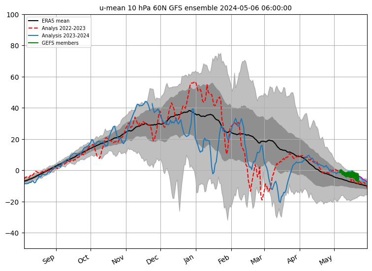
Zonal winds at 60 N @ 10hpa are record breakingly positive now - but should weaken.


Home Location - Kellands Lane, Okehampton, Devon (200m ASL)
---------------------------------------
Sean Moon
Magical Moon
www.magical-moon.com


Surrey John
14 January 2020 16:04:30

Slightly odd chart, West of Ireland colder than UK in February


Is it a cold plume from Greenland ?


http://modeles.meteociel.fr/modeles/cfs/runs/202001140706/run1m/cfs-2-594.png?06


Bradford on Avon, Wiltshire
35m ASL
tallyho_83
14 January 2020 17:48:40

Seeing as the GFS have been so uninspiring this winter for first half anyway - let's look at the temps in stratosphere @ 10hpa - Looks like there could be a change or any interest? - let's see if this trend continues as there are signs of a SW? Even if we don't get a SSW we could get a SW which could weaken the PV - from +300z: 


Warming starts over Siberia then warms further into the Arctic instead of cools..


+324:


+348


+372 - We have -24c @ 10hpa right over the top of the pole.


Let's see if this trend continues? I am weary after previous attempts have failed but this is more likely now we are well into January. 


  • Maybe this SW could get us out of this continuous zonal mild and wet mess! Positives signs about the SSTs in the tropical Indian Ocean which have recently returned to normal, which has already brought some relief to those wildfires/forest fires in Australia and this is set to continue. So more rain for them and it has been said that the SST's in the Indian ocean which have been so strong has actually helped to fuel the jet and drive depressions our way -  so maybe we could see a change soon, only maybe - the whole of Europe needs to see a change and soon. It's exceptionally mild even in the north east of Europe too.


Home Location - Kellands Lane, Okehampton, Devon (200m ASL)
---------------------------------------
Sean Moon
Magical Moon
www.magical-moon.com


jhall
14 January 2020 18:10:18

The interesting thing about those stratospheric charts is that by T+324 the PV seems to be centred over Scandinavia, which I don't think is where it's usually to be found. Hopefully that might improve the chances of northerlies for the UK.


Cranleigh, Surrey
tallyho_83
14 January 2020 18:11:55

Originally Posted by: tallyho_83 


Seeing as the GFS have been so uninspiring this winter for first half anyway - let's look at the temps in stratosphere @ 10hpa - Looks like there could be a change or any interest? - let's see if this trend continues as there are signs of a SW? Even if we don't get a SSW we could get a SW which could weaken the PV - from +300z: 


Warming starts over Siberia then warms further into the Arctic instead of cools..


+324:


+348


+372 - We have -24c @ 10hpa right over the top of the pole.


Let's see if this trend continues? I am weary after previous attempts have failed but this is more likely now we are well into January. 


  • Maybe this SW could get us out of this continuous zonal mild and wet mess! Positives signs about the SSTs in the tropical Indian Ocean which have recently returned to normal, which has already brought some relief to those wildfires/forest fires in Australia and this is set to continue. So more rain for them and it has been said that the SST's in the Indian ocean which have been so strong has actually helped to fuel the jet and drive depressions our way -  so maybe we could see a change soon, only maybe - the whole of Europe needs to see a change and soon. It's exceptionally mild even in the north east of Europe too.


Why are the temps different @ 10hpa on TWO compared to Meteociel?


same date/time and same run not different temp?


Home Location - Kellands Lane, Okehampton, Devon (200m ASL)
---------------------------------------
Sean Moon
Magical Moon
www.magical-moon.com


doctormog
14 January 2020 18:20:51

Are you comparing the control with the operational run? Apart from that, at that range using a single member of a single model on a single run and a single parameter is a little bit, how should I put it, unhelpful.


Edit: For what it is worth this is the Meteociel chart that corresponds to the TWO one (GFS op run) http://modeles.meteociel.fr/modeles/gfs/runs/2020011412/gfsnh-10-372.png?12 


Unsurprisingly they show the same thing. 


Arcus
14 January 2020 18:26:15

Originally Posted by: doctormog 

Are you comparing the control with the operational run? Apart from that, at that range using a single member of a single model on a single run and a single parameter is a little bit, how should I put it, unhelpful.


Was about to post the same 


Anyway looks to me like a similar projection to those being made back in November last year. The PV is merely moving around the ring swatting aside any swipes made at it. 


Ben,
Nr. Easingwold, North Yorkshire
30m asl
tallyho_83
14 January 2020 18:34:37

Originally Posted by: Arcus 


Was about to post the same 


Anyway looks to me like a similar projection to those being made back in November last year. The PV is merely moving around the ring swatting aside any swipes made at it. 


Argh! I didn't realise it was the control run! Besides - no wonder it's a;lways wrong.


Home Location - Kellands Lane, Okehampton, Devon (200m ASL)
---------------------------------------
Sean Moon
Magical Moon
www.magical-moon.com


tallyho_83
14 January 2020 18:38:12

Originally Posted by: doctormog 


Are you comparing the control with the operational run? Apart from that, at that range using a single member of a single model on a single run and a single parameter is a little bit, how should I put it, unhelpful.


Edit: For what it is worth this is the Meteociel chart that corresponds to the TWO one (GFS op run) http://modeles.meteociel.fr/modeles/gfs/runs/2020011412/gfsnh-10-372.png?12 


Unsurprisingly they show the same thing. 


This is link I use and have always followed - 


http://www.meteociel.fr/modeles/gefs_cartes.php?code=0&ech=324&mode=7&carte=1


How do I get to operational?


Home Location - Kellands Lane, Okehampton, Devon (200m ASL)
---------------------------------------
Sean Moon
Magical Moon
www.magical-moon.com


doctormog
14 January 2020 18:41:55
Users browsing this topic

Ads