The Weather Outlook

Remove ads from site

Chunky Pea
13 September 2019 12:08:16

 EC seasonal is possible the worst seasonal model of them all.

Originally Posted by: Solar Cycles 

A hugely over-rated seasonal model. Don't know how it performs for other parts of the world, but for W. Europe, it is rubbish. 


Patrick,

East Galway, Ireland.

Solar Cycles
13 September 2019 15:11:24


A hugely over-rated seasonal model. Don't know how it performs for other parts of the world, but for W. Europe, it is rubbish. 

Originally Posted by: Chunky Pea 

Indeed, and more so when considering how much they charge for this third rate forecasting tool.๐Ÿ˜‚๐Ÿ˜‚

severnside
13 September 2019 17:50:15

Prior to its update a few season back GLOSEA was a fairly good seasonal model, since then its hopeless and the EC seasonal is possible the worst seasonal model of them all.

Originally Posted by: Solar Cycles 

My take on this is because the programmers are being forced to put in a bias for the so called "global warming" or "climate change" or whatever they want to call it, in the algorithms, equates to rubbish in, rubbish out.

Arcus
13 September 2019 18:20:29


My take on this is because the programmers are being forced to put in a bias for the so called "global warming" or "climate change" or whatever they want to call it, in the algorithms, equates to rubbish in, rubbish out.

Originally Posted by: severnside 

RIRO would indicate a problem with the source data rather than the programming. Just sayin'. 


Ben,

Nr. Easingwold, North Yorkshire

30m asl

tallyho_83
13 September 2019 22:36:17


Not sure that was the case, despite the unsually warm spell during mid-late February. I seem to remember reading on this forum not long afterwards that February 1998 (and possibly 2002 as well) had a warmer overall CET than the same month this year did. This was likely due to Feb 1998 being mild/very mild until almost the end of the month whereas that month this year did start off quite cold in places.

I stand corrected if I am wrong about that though.

Originally Posted by: David M Porter 


I think Feb 1998 was mild wet and Feb 2019 was dry and mild and it felt warm!!? This Feb 2019 was dry and warm and not mild wet south westerlies!!


Home Location - Vixen Tor Close, Okehampton, Devon (221m ASL)

---------------------------------------

Sean Moon

Magical Moon

www.magical-moon.com

Solar Cycles
13 September 2019 22:42:06


My take on this is because the programmers are being forced to put in a bias for the so called "global warming" or "climate change" or whatever they want to call it, in the algorithms, equates to rubbish in, rubbish out.

Originally Posted by: severnside 

Eek.....Talk like that around here can get you banned.......... 


I agree though. ๐Ÿ˜‚๐Ÿ˜‚๐Ÿ˜‚

Broadmayne Blizzard
14 September 2019 15:23:34
Wasn't it just last winter that both the ec monthly and seasonal models kept going for Northern blocking to develop in the mid range only for it never to appear or get a foothold. I also seem to remember the Met officeor the BBC guys doing a get ready because winters on the way video.

As for Glosea I have yet to be convince of its use as a reliable seasonal forecasting tool.


Formerly Blizzard of 78
richardabdn
18 September 2019 17:22:24

Article in the local paper today:

https://www.eveningexpress.co.uk/fp/news/local/aberdeen-gearing-up-for-return-of-beast-from-the-east/

A good example of the phenomenon known as ‘The Mandela Effect’

https://theconversation.com/the-mandela-effect-and-how-your-mind-is-playing-tricks-on-you-89544

Either that or an indication of how bland the climate is becoming when the media are essentially having to make up news pertaining to non-existent extreme weather 


Aberdeen: The only place that misses out on everything

2023 - The Year that's Constantly Worse than a Bad November

2024 - 2023 without the Good Bits

2025 - The Weekend Curse hell intensifies

tallyho_83
19 September 2019 01:12:23

Wasn't it just last winter that both the ec monthly and seasonal models kept going for Northern blocking to develop in the mid range only for it never to appear or get a foothold.

Originally Posted by: Broadmayne Blizzard 

Yes all say coldest winter on the way, blizzards, beast from the east or last year 4 months of snow! and you were right all models showed blocked and cold Feb esp met Office Glosea 5 seasonal model- only for it to turn out to be a dry and warm RECORD breaking Feb! So who know's what can happen? Fingers crossed for a winter this time around. We need a cold festive and snowy Christmas! A cold seasonal Christmas is long over due isn't it!??


Home Location - Vixen Tor Close, Okehampton, Devon (221m ASL)

---------------------------------------

Sean Moon

Magical Moon

www.magical-moon.com

Gusty
19 September 2019 10:15:00

I followed all the seasonal model analysis updates very closely on the run up to and during winter last year.

To be honest I was left feeling extremely disappointed by the constant chop and changing and overall poor verification stats they provided.

I hope for a variable winter offering a bit of everything, including a week long deep freeze at some point between mid December and late January but I shall not be investing my time, energy and emotion tracking it. 

If by chance we do get some cross model agreement at 72 hours for something exceptional then I may allow myself to get all silly ! 


Steve - Folkestone, Kent

Current conditions from my Davis Vantage Vue

https://www.wunderground.com/dashboard/pws/IFOLKE11 

Join Kent Weather on Facebook.

https://www.facebook.com/stevewall69/ 


tallyho_83
20 September 2019 01:14:20

If by chance we do get some cross model agreement at 72 hours for something exceptional then I may allow myself to get all silly ! 

Originally Posted by: Gusty 


Exactly Steve!

Models let us down last winter esp given that we had a SSW too and whilst we all thought there was still time for us to get HLB or some SCANDINAVIAN HP etc in February like many or all models were forecasting - it turned out to be the exact opposite didn't it with warmest Feb ever recorded and somewhere in the UK reached 21c in Feb 19? - Just so crazy!! - Also it wasn't for a few days it was notably warmer and this warmth lasted for 2-3 weeks in February!! People along Exeter Quay were having picnics at half term in short sleeves and I was in Sidmouth on 15th Feb and people were sunbathing in shorts too having ice creams! - It was a warm dry not a mild wet'.

I will try not to take notice of any models until there is cross model agreement at 72 hrs.

If we can keep breaking records for hot days and nights and so on surely one day we will get a record breaking cold day in winter or something; if this makes sense?

The good news about this winter is that the SST's are warmer off the south coast of Greenland and Iceland in N. Atlantic (Opposite to this time last year), we are at Grand solar Minimum and this winter we are going from a westerly QBO to easterly (opposite of last winter) and a potential of a ENSO neutral winter. On top of that we have the potential of a -NAO given the tripol in May...!?

Fingers crossed!!


Home Location - Vixen Tor Close, Okehampton, Devon (221m ASL)

---------------------------------------

Sean Moon

Magical Moon

www.magical-moon.com

johncs2016
20 September 2019 07:35:41
Ideally, I would like to see a cold winter with plenty of snow and frost. Failing that though and regardless of whether we end up with a cold winter or a mild one, I just want to see something actually happening with regards to our weather so that I have something different to report on this forum instead of that same old borefest which we have seen during this autumn so far.

Having said that though, I do live in one of the most boring places in the UK on average when it comes to our weather, which means that actually getting some "interesting" weather here may well be too much to ask for.


The north of Edinburgh, usually always missing out on snow events which occur not just within the rest of Scotland or the UK, but also within the rest of Edinburgh.

tallyho_83
20 September 2019 09:39:02

Ideally, I would like to see a cold winter with plenty of snow and frost. Failing that though and regardless of whether we end up with a cold winter or a mild one, I just want to see something actually happening with regards to our weather so that I have something different to report on this forum instead of that same old borefest which we have seen during this autumn so far.

Having said that though, I do live in one of the most boring places in the UK on average when it comes to our weather, which means that actually getting some "interesting" weather here may well be too much to ask for.

Originally Posted by: johncs2016 


Well, you said it...

https://www.metoffice.gov.uk/weather/forecast/gcvwr3zrw


Home Location - Vixen Tor Close, Okehampton, Devon (221m ASL)

---------------------------------------

Sean Moon

Magical Moon

www.magical-moon.com

tallyho_83
02 October 2019 13:49:53

Good start for early snow cover in Siberia and as you can see there are some white patches appearing in Scandinavia too! - An impressive start, (given we're only in early October):  - Hope this trend continues!


Home Location - Vixen Tor Close, Okehampton, Devon (221m ASL)

---------------------------------------

Sean Moon

Magical Moon

www.magical-moon.com

White Meadows
03 October 2019 06:03:25

Good start for early snow cover in Siberia and as you can see there are some white patches appearing in Scandinavia too! - An impressive start, (given we're only in early October):  - Hope this trend continues!

Originally Posted by: tallyho_83 

your link didn’t work for me, but I think you mean this one: 

https://www.natice.noaa.gov/pub/ims/ims_gif/DATA/cursnow_asiaeurope.gif


Looks fairly normal to me?

Russwirral
03 October 2019 09:09:13


your link didn’t work for me, but I think you mean this one: 

https://www.natice.noaa.gov/pub/ims/ims_gif/DATA/cursnow_asiaeurope.gif


Looks fairly normal to me?

Originally Posted by: White Meadows 


I think the understatement is the start for Scandinavia... .thats usually the last place on that latitude to get snow cover, usually well into November.


Rob K
03 October 2019 11:18:52


Not sure that was the case, despite the unsually warm spell during mid-late February.

Originally Posted by: David M Porter 

I assumed he meant warmest February day ever, which we did of course.

Feb this year was an interesting month. Very heavy wet snow right at the start (10-12cm here) which led to trees coming down and blocking several roads in this area, then three weeks later we were basking in 20C+ warmth.


Yateley, NE Hampshire, 73m asl

"But who wants to be foretold the weather? It is bad enough when it comes, without our having the misery of knowing about it beforehand." โ€” Jerome K. Jerome

tallyho_83
03 October 2019 11:26:37


your link didn’t work for me, but I think you mean this one: 

https://www.natice.noaa.gov/pub/ims/ims_gif/DATA/cursnow_asiaeurope.gif


Looks fairly normal to me?

Originally Posted by: White Meadows 

not working?? How come? What do you mean? should be an image?

Look how much snow cover there is over many parts of Siberia and Northern Russia and even Mongolia already has snow cover too as well as parts of Scandinavia - and remember the early snowstorm in the Northern states of the USA like Montana on 30th Sept and into Canada ! I would say this is pretty impressive given October is only a few days old.


Home Location - Vixen Tor Close, Okehampton, Devon (221m ASL)

---------------------------------------

Sean Moon

Magical Moon

www.magical-moon.com

ballamar
03 October 2019 11:28:03
Models do appear quite blocked in later stages and not in their usual spots. Does it mean anything no, but could we get a late October cold snap potentially yes
Steve Murr
03 October 2019 13:00:57

Models do appear quite blocked in later stages and not in their usual spots. Does it mean anything no, but could we get a late October cold snap potentially yes

Originally Posted by: ballamar 

The current run ( from April 26 ) to date of the -NAO has been caused by a strong final warming in the stratosphere in early April & the residual warm in the troposphere all summer due to ice loss upward forcing-

The current normalized polar height anomaly captures this well.
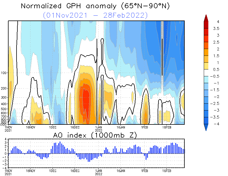
This winter ( which I will add into the form of a thread at some point ) will hinge around how long the troposphere & its residual warmth can stay disconnected to the downwelling of the colder stratosphere as well as staying in the blocked stage without attack from the tropospheric influencers - The main 2 being

  • A super Nino which strongly impact the pacific jet ( luckily a SuperNino )
  • High magnitude of sunspot activity

Luckily both of the aforementioned variables are well placed this year.

Current persistence of blocking over the pole is expected to last all of October.

** Key dates & phases are mid November when stratospheric downwelling becomes harder to fend off & upward heat flux needs to counter balance the downwelling. 

Historically the 'norm' of the arctic is there is minimal counter balance until a SSW downwells warmth from the strat however this year our starting position is good in the troposhere ( but only based on the summer persistence )

The real driver if there is one is Arctic climate change which is injecting some disproportionate warmth into the pole through reduced sea ice - as well as the SAI that should support a further positive feedback loop.

With all that said & done the status quo then should remains for a good few weeks with Northern blocking featuring & critically further injections of abnormal warmth into the pole especially towards western Greenland. - These events & the SAI ( as well as the sun activity ) are the variables that are presenting themselves this year as the 'possible' counter balances. The best example of which is also fits perfectly into the sunspot cycle is 2009 > 10

Which saw a perfect counter balance in November...

So this is the date to look for ( Mid Nov ) in terms what the polar profile looks like -


Many thanks 

Steve

Maunder Minimum
03 October 2019 13:30:22

Good to see your contribution Steve and an interesting one as always. We are due for something and given the lack of solar activity and other factors, who knows? Maybe 2019-20 will be a winter to remember - we can always hope so.


New world order coming.
Solar Cycles
03 October 2019 15:29:37
The anomalous warmth around the NW Canadian Pacific sector doesnโ€™t bode well for a colder than average winter for these shores, itโ€™s been a bogeyman in recent years. I still think itโ€™s too early in the season for compiling analogues and looking at specific details on how the NAO has behaved over recent months.....

A lot of factors to take on board but until we get into next month itโ€™s even more speculative than usual really.

tallyho_83
04 October 2019 00:04:08

Can anyone get this page to load on this long range severe-weather.eu site:

Anyone getting nothing when they click read more?


http://www.severe-weather.eu/long-range-2/winter-2019-2020-early-look/


Home Location - Vixen Tor Close, Okehampton, Devon (221m ASL)

---------------------------------------

Sean Moon

Magical Moon

www.magical-moon.com

some faraway beach
04 October 2019 09:12:26
"SA!"?
2 miles west of Taunton, 32 m asl, where "milder air moving in from the west" becomes SNOWMAGEDDON.

Well, two or three times a decade it does, anyway.

tallyho_83
04 October 2019 09:35:00

"SA!"?

Originally Posted by: some faraway beach 


Home Location - Vixen Tor Close, Okehampton, Devon (221m ASL)

---------------------------------------

Sean Moon

Magical Moon

www.magical-moon.com

Remove ads from site