The Weather Outlook

Remove ads from site

wallaw
03 January 2019 10:11:51


A direct northerly is actually the best option for here and, given recent output, I’d say there is a chance of a cold one at some stage in the next few weeks in the middle of what seems to me to be a more likely NEly scenario.

All very interesting and as you say, so far, the 06z GFS op run is following that trend up to day 4/5. Hopefully the whole run will be good. 

Originally Posted by: doctormog 

It's a similar scenario here too Doc, we seem to miss out a little in a fairly slack N/Ely flow, perhaps SST's over the last decade are to blame as the moderation this close to the North Sea always impacts on the precipitation type without elevation. 

I do think we will see a pretty good northerly before the month end though and for here that could be our best chance of lying snow. Certainly fascinating model watching over the next 48 hrs


Ian

Stockton-on-Tees

Ally Pally Snowman
03 January 2019 10:25:23

Much better GFS 6z. Could be some snow around next week?


Bishop's Stortford 85m ASL.
Whiteout
03 January 2019 10:27:13

Wow, upgrade on GFS too, could this be what we have been waiting to see


Home/Work - Dartmoor

240m/785 ft asl

idj20
03 January 2019 10:38:13

Much better GFS 6z. Could be some snow around next week?

Originally Posted by: Ally Pally Snowman 


I've noticed that too with the model playing about with the idea of a longer lasting easterly airflow at my neck of the woods, even ECM isn't that far off it. But, 1) at around 190 hrs mean this latest run mustn't be taken into isolation, and 2) at uppers of -6 c to -8 c, will that be good enough for snow production come the moment? Ideally I'd like to see anything -12 c & below 850's to make me lift an eyebrow.


Home location: Folkestone Harbour.
Rob K
03 January 2019 10:40:34
Close to a decent easterly on the 6Z GFS op. The downside is that the quicker ridging to the northeast cuts off the flow of cold air from the Arctic so there's not much of a cold pool to tap into.
Yateley, NE Hampshire, 73m asl

"But who wants to be foretold the weather? It is bad enough when it comes, without our having the misery of knowing about it beforehand." — Jerome K. Jerome

tallyho_83
03 January 2019 10:46:19

Definitely an upgrade the GFS op 00z @ around 180 sinks the high pressure TO the south and LOW pressure flattens it and it's a toppler compared with the 06z @ that time builds HP to our north and north east over Scandi! Looks like any unsettled spell will be brief with more chance of colder weather by mid month!


00z


Latest 06z


Home Location - Vixen Tor Close, Okehampton, Devon (221m ASL)

---------------------------------------

Sean Moon

Magical Moon

www.magical-moon.com

Russwirral
03 January 2019 10:47:02
Steve Murrs's earlier forecast is blob on. 6z gives us a nic e upgrade with snow for some as early as next tuesday, maybe earlier for favoured spots.

Finishes with HP with -5s quite widely. Should that translate to clear skies, we could be looking at widespread severe frosts maybe minus double digits


Solar Cycles
03 January 2019 10:50:22
That’s GFS and the ICON vs the Euros and GEM. Until we have more consensus from the EUROS then whilst it’s pretty to look at these charts until they climb aboard I’m not enthused.
marco 79
03 January 2019 10:59:03
Gfs has Wintry potential into NE Scotland @120hrs.....and many Eastern areas of England not long after...
Home : Mid Leicestershire ...135m ASL
Rob K
03 January 2019 10:59:26

Close to a decent easterly on the 6Z GFS op. The downside is that the quicker ridging to the northeast cuts off the flow of cold air from the Arctic so there's not much of a cold pool to tap into.

Originally Posted by: Rob K 

However by the end -20s have flooded into Scandinavia and it looks ripe for a second bite at the cherry.


Yateley, NE Hampshire, 73m asl

"But who wants to be foretold the weather? It is bad enough when it comes, without our having the misery of knowing about it beforehand." — Jerome K. Jerome

Maunder Minimum
03 January 2019 11:01:28

Worth looking at this 10hpa graphic - this is now, not a forecast:

https://earth.nullschool.net/#current/wind/isobaric/10hPa/overlay=temp/orthographic=0.62,87.41,216

Split of the PV is self evident as is the reversal of winds aloft.


New world order coming.
tallyho_83
03 January 2019 11:05:10

Havent posted for a few days here other than to have added that link summerising why the GFS will have been so poor in this period of model watching, indeed scan back through this thread just 5 days ago & every bit of commentary around the GFS forecast in terms of 'return to zonal conditions' & 'zonal reset' etc etc all turned out to be totally wrong, if it was a game of Cricket the GFS ball would certainly be a 'wide' - although a footnote to the future - the FV3 has been 'ok'

As mentioned on the otherside, today is the day the models will get a grip on the 'non phasing' event of the 2 atlantic lows around T72, as the lower resolution models begin to resolve the seperation of these 2 areas of energy ( thats every model apart from the Euros ) then so we should see better amplification around 120-144 leading to a more uniform model suite.
The EPS & GEFS clustering at day 7 overnight both made significant adjustments NW with the developing High at day 7 & I expect this to continue today - so a day of upgrades today-
I think day 6 & day 7 will bring the -8c isotherm widely into the UK- Maybe -9/-10 into the NE as an exception- it then holds in situ as a NE flow develops.

So chilly till about Tues - weds then much colder from the NE with some of the white stuff...

Originally Posted by: Steve Murr 

Actually good summary that . Definitely an upgrade too and showing more cold in line with what the Met Office were saying around Mid month and have been for weeks. No return to anything zonal and or mild either! Hope these upgrades continue as it has been a really dire season of model watching so far and at long last it looks like the models are starting to pick up on this SSW. Will be keen to see what the 20 other GFS ensembles show on the 06z run.


Home Location - Vixen Tor Close, Okehampton, Devon (221m ASL)

---------------------------------------

Sean Moon

Magical Moon

www.magical-moon.com

JOHN NI
03 January 2019 11:44:26
Very large scatter becoming apparent on the 0600 GFS ensembles from as early as next Tuesday. 0600 Operational lies towards the colder end of things but by no means unsupported. Some significantly less cold /milder options in the mix for some considerable time also. So still a lot of uncertainty on the evolution and type of weather on offer beyond next Tuesday - but (steady as she goes) - the trend towards colder (perhaps much colder) continues.
John.

The orange County of Armagh.

roger63
03 January 2019 12:22:48

Very large scatter becoming apparent on the 0600 GFS ensembles from as early as next Tuesday. 0600 Operational lies towards the colder end of things but by no means unsupported. Some significantly less cold /milder options in the mix for some considerable time also. So still a lot of uncertainty on the evolution and type of weather on offer beyond next Tuesday - but (steady as she goes) - the trend towards colder (perhaps much colder) continues.

Originally Posted by: JOHN NI 

Longer term out in FI ,cold members of  GEFS 06h just have a slight majority but nothing that is consistent enough to flag up the change that METO expect.

However the shorter term as Steve has posted looks more promising.

Rob K
03 January 2019 12:34:18

The shift in the ensembles is quite large from yesterday's 12Z:


to today's 6Z:


The mean now stays below zero for the whole run from the 8th.


Yateley, NE Hampshire, 73m asl

"But who wants to be foretold the weather? It is bad enough when it comes, without our having the misery of knowing about it beforehand." — Jerome K. Jerome

Karl Guille
03 January 2019 12:52:50

Definitely the coldest set IMBY too with at least half a dozen runs staying below -5 850hPA for a number of days!

Diagramme GEFS


St. Sampson

Guernsey

tallyho_83
03 January 2019 12:55:40

Just been browsing through FI ensembles which go to 19th Jan:

Been a long wait (all December at into Jan) to see these sort of blocked charts!

Some of the coldest ones -14 c @ 850hpa:
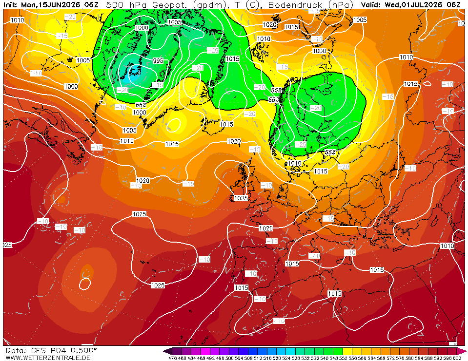
p4 (-8c @ 850hpa)


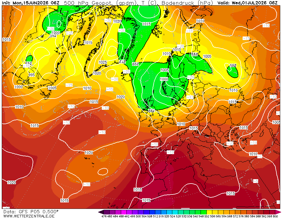
P5 (-13c @ 850 hpa) - Perhaps the coldest ensemble member? - Plus heavy snow to the south of UK WITH gale force easterly winds?


P8: (-7c @ 850 hpa)


P9: (-7 to -8c @ 850hpa)


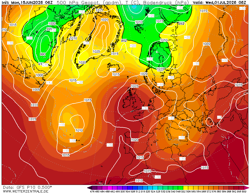
P10: (-7 TO -8C @ 850hpa)


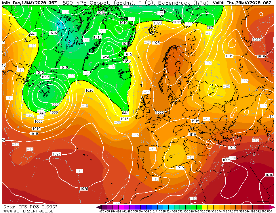
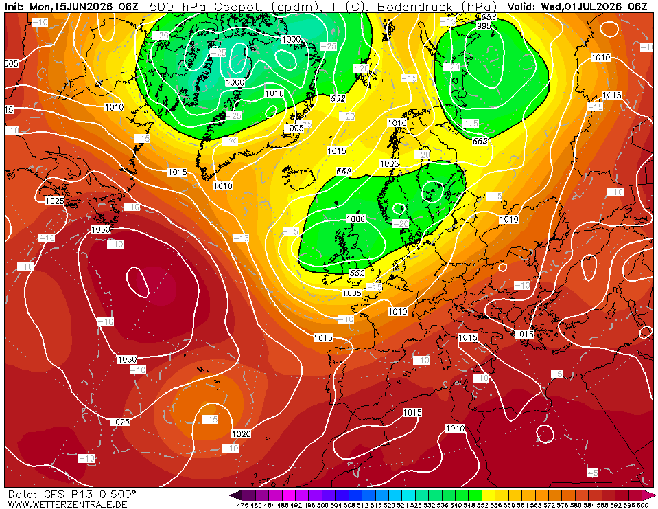
P13: (-5 TO -6C @ 850hpa)


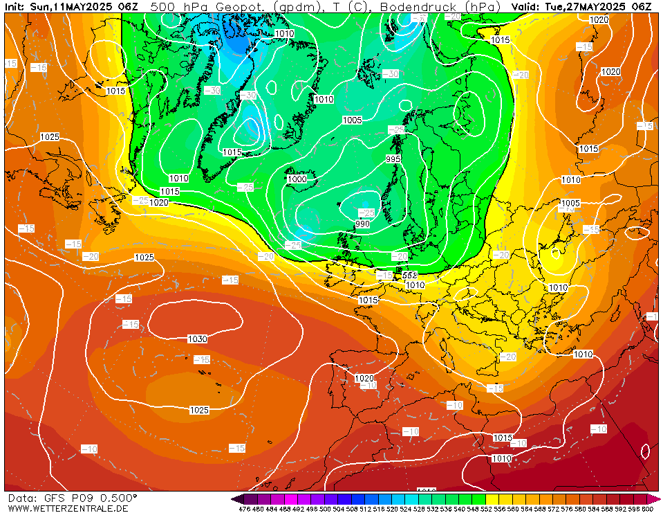
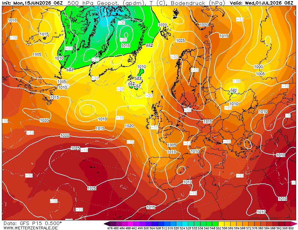
P15 (-10C @ 850hpa approaching N Scotland & ridge builds over Greenland)


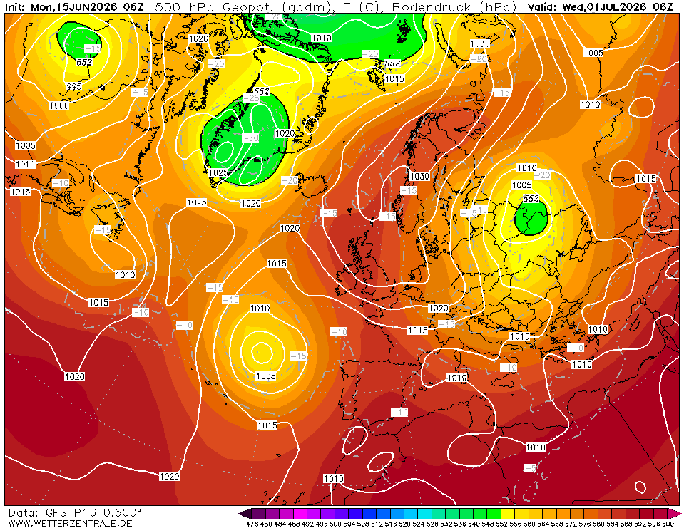
 P16: (-10c @850hpa - this time covering the majority of the UK)


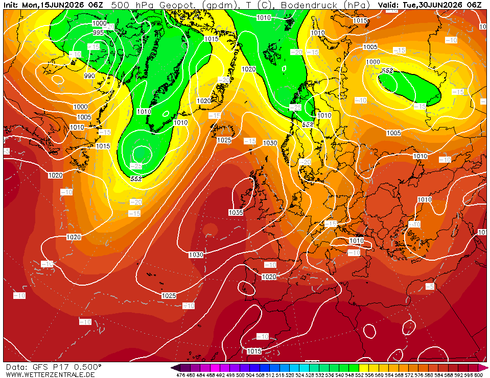
P17 SHOWS A Potential blizzard scenario as the LP moves into the cold block: (-5 to -7c uppers).


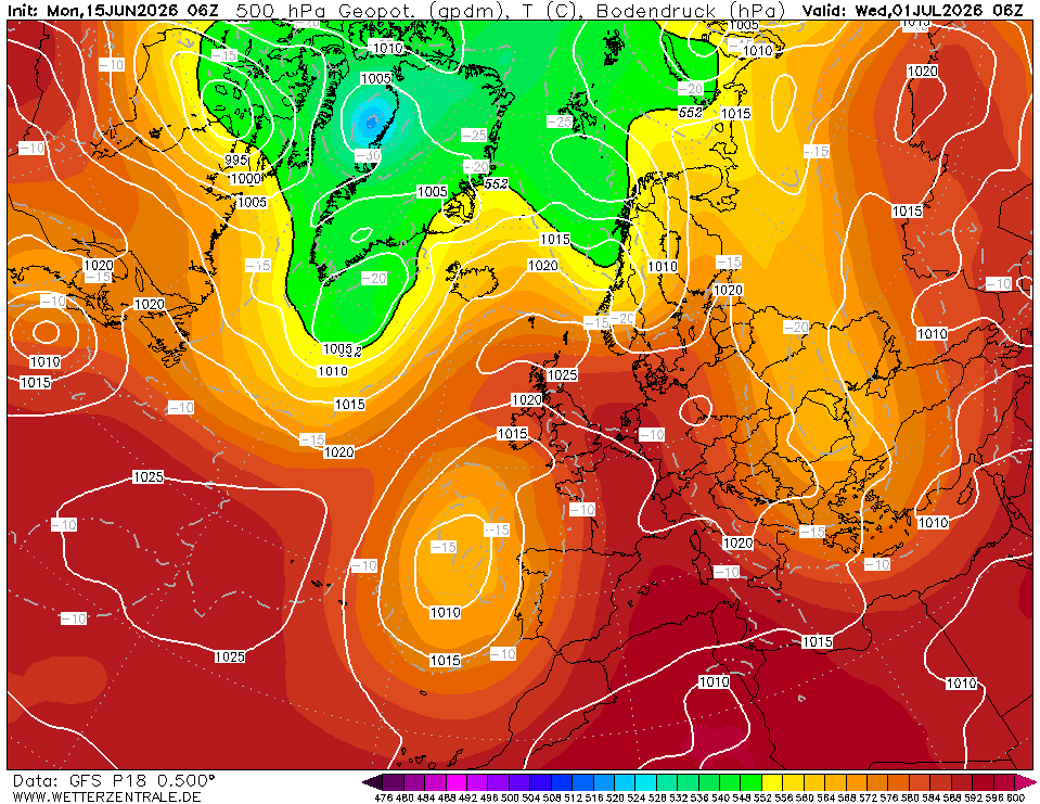
P18: (-5 to -7c @ 850hpa)


p20: far south and east shows -10c @ 850hpa). - That azores HP doesn't help though!


Home Location - Vixen Tor Close, Okehampton, Devon (221m ASL)

---------------------------------------

Sean Moon

Magical Moon

www.magical-moon.com

Ally Pally Snowman
03 January 2019 13:41:04

I wrote underwhelming for yesterday's 12z set this is much better shows how things can change very quickly snow rows upto 51!


Bishop's Stortford 85m ASL.
DPower
03 January 2019 14:00:48

Great to see charts showing something much more akin to winter than what we have seen these last few weeks.
The gph charts at 10mb offer a mouth watering insight to what may well lie ahead with hopefully next weeks cold being just a taster of what is potentially around the corner. I wouldn't rule anything out be it an extended version of Feb 91, Jan 87 or end of Feb 18.

Brian Gaze
03 January 2019 14:13:53

NCEP have just notified of possible data distribution issues, so GFS / GEFS may (or may not) be late this afternoon.


Brian Gaze

Berkhamsted

TWO Buzz - get the latest news and views 

"I'm not socialist, I know that. I don't believe in sharing my money." - Gary Numan

Maunder Minimum
03 January 2019 14:15:41

NCEP have just notified of possible data distribution issues, so GFS / GEFS may (or may not) be late this afternoon.

Originally Posted by: Brian Gaze 

I do wonder whether the government shutdown Stateside is having an effect too.


New world order coming.
Saint Snow
03 January 2019 15:22:42

The GEFS for various locations around the UK gave similarly decent overall prospects for cold & snow. Obviously some level of regional variation in different runs, but it wasn't slanted toward favouring one particular area.


Martin

Home: St Helens (26m asl) Work: Manchester (75m asl)

A TWO addict since 14/12/01

"How can wealth persuade poverty to use its political freedom to keep wealth in power? Here lies the whole art of Conservative politics."

Aneurin Bevan

Brian Gaze
03 January 2019 15:44:49

GFS 12z looks to be downloading ok on TWO and Meteo, WZ appears to be having issues. Link for TWO is:

https://www.theweatheroutlook.com/twodata/gfs.aspx

Edit t+60 @ 15:46.


Brian Gaze

Berkhamsted

TWO Buzz - get the latest news and views 

"I'm not socialist, I know that. I don't believe in sharing my money." - Gary Numan

nsrobins
03 January 2019 15:57:51

Consistant anyway - we can argue about the ‘borderline’ 850s later 😉 GFS looks to be again nodding in the direction of ICON but we’re in shortwave territory at 78hrs and how it helps it hinders the amplification.


Neil

Fareham, Hampshire 28m ASL (near estuary)

Stormchaser, Member TORRO

Remove ads from site