The Weather Outlook

Remove ads from site

Russwirral
21 January 2024 21:04:12
Gone from windy to stormy in about 10 mins. 

Few people have experienced 70mphs wind in land. Today will come ad a surprise to lots of sheltered people just how disruptive winds can be.


DEW
  • DEW
  • Advanced Member
21 January 2024 21:04:54
MetO rainfall chart shows a sting in the tail, a narrow but intense band of rain working south-eastwards. Looks like a squall line with a sudden brief increase in gusty winds.

Currently just leaving SE Ireland, it moves to Wales and the west country midnight to 1am , Exeter to the Wash at 3am, Sussex to Thames Estuary at 5am, and breaks up over the Dover Straits at 7am. having preserved a striking integrity until then, being perhaps 200 miles long but only some 10 miles wide


I can calculate the movements of stars, but not the madness of men - Isaac Newton

Chichester 12m asl

Roger Parsons
21 January 2024 21:17:08
A bit of a wind here but nothing exciting - yet.
RogerP

West Lindsey district of Lincolnshire

Everything taken together, here in Lincolnshire are more good things than man could have had the conscience to ask.

William Cobbett, in his Rural Rides - c.1830

Lionel Hutz
21 January 2024 21:17:24

MetO rainfall chart shows a sting in the tail, a narrow but intense band of rain working south-eastwards. Looks like a squall line with a sudden brief increase in gusty winds.

Currently just leaving SE Ireland, it moves to Wales and the west country midnight to 1am , Exeter to the Wash at 3am, Sussex to Thames Estuary at 5am, and breaks up over the Dover Straits at 7am. having preserved a striking integrity until then, being perhaps 200 miles long but only some 10 miles wide

Originally Posted by: DEW 

That's interesting. While not calm, the winds aren't too bad here at present. However, we had quite a windy spell around 5pm this evening which would tie in with the squall line.


Lionel Hutz

Nr.Waterford , S E Ireland

68m ASL


dagspot
21 January 2024 21:17:33
apparently Storm Isha is the windiest place on planet right now
Neilston 600ft ASL
Jim-55
21 January 2024 21:39:34
I think the worst has passed here although the worst wasn't that bad, we've had a few nasty gusts but overall not too bad.


Previously JimC. joined back then in 2009. Frome, N/E Somerset, 125mtrs asl.
scillydave
21 January 2024 21:42:39
It's not been quite as bad here (so far) as it was originally forecast to be. The Met Office App (and BBC) have knocked about 4mph off tonight's peak sustained wind and about 6mph off the top gust this afternoon compared with this morning's forecast.  

As such it's windy our but doesn't feel too badtin this small area of the UK.

Interesting seeing reports coming in from across the UK. Lots of inland gusts in the 50mph range across thd Southern half but few that are particularly noteworthy except perhaps Oldiham with 70mph at 9pm.

Still definitely warrants the Amber mind you.


Currently living at roughly 65m asl North of Cowbridge in the Vale of Glamorgan.

Formerly of, Birdlip, highest village in the Cotswolds and snow heaven in winter; Hawkinge in Kent - roof of the South downs and Isles of Scilly, paradise in the UK.

four
  • four
  • Advanced Member
21 January 2024 21:45:25
A couple of gusts around 63mph it is odd how it rather dies down then another gusty period comes through.

Christmas Eve we had over 70mph so much less than that indeed 60mph is normal here on days with no warnings at all.  


Ulric
21 January 2024 21:45:58
Its a bit livelier than I expected here in North Herts. Gusting to 50mph.

Facebook reporting some trees down, blocking roads.


"To ravage, to slaughter, to usurp under false titles, they call empire; and where they make a desert, they call it peace." ~ Tacitus, 56 AD - 117AD
glenogle
21 January 2024 21:46:10
Wind starting to pick up here now.  Strongest expected to be 11pm to 1am ish.  Power has tripped off twice already but only for a min or so, so just a short term inconvenience while everything reboots.

glencoe ski resort had 125mph gust earlier at its summit.


UserPostedImage LLTNP 105m asl 
Saint Snow
21 January 2024 21:46:21
Met Office has the worst hitting here between 10pm - 1am

Meanwhile, it seems Aberdaron (western tip of the Lleyn Peninsula) has had peak gust rate of 89mph


Martin

Home: St Helens (26m asl) Work: Manchester (75m asl)

A TWO addict since 14/12/01

"How can wealth persuade poverty to use its political freedom to keep wealth in power? Here lies the whole art of Conservative politics."

Aneurin Bevan

Chunky Pea
21 January 2024 22:01:20
Gusts of 70 knots at finner camp in South Donegal, a bit stronger than the 68 at Malin head on the exposed northern coastal peninsula. 
Patrick,

East Galway, Ireland.

Bolty
21 January 2024 22:37:58
Wind gusting to about 50mph here. The temperature is also still rising as well, as it's now 12.5°C making it the mildest day since Christmas Eve.
Scott

Blackrod, Lancashire (4 miles south of Chorley) at 156m asl.

My weather station 

Matty H
21 January 2024 22:50:12
That it? We are in the Amber warning area. It’s still blowy now, but that’s all it has been - blowy

Not that I’m complaining. Absolute result!


Yate, Nr Bristol

TBFTEIARBSC

Rob K
21 January 2024 23:23:54

MetO rainfall chart shows a sting in the tail, a narrow but intense band of rain working south-eastwards. Looks like a squall line with a sudden brief increase in gusty winds.

Currently just leaving SE Ireland, it moves to Wales and the west country midnight to 1am , Exeter to the Wash at 3am, Sussex to Thames Estuary at 5am, and breaks up over the Dover Straits at 7am. having preserved a striking integrity until then, being perhaps 200 miles long but only some 10 miles wide

Originally Posted by: DEW 

Is that the intense feature showing on the radar over the coast of south Wales now?


Yateley, NE Hampshire, 73m asl

"But who wants to be foretold the weather? It is bad enough when it comes, without our having the misery of knowing about it beforehand." — Jerome K. Jerome

Rob K
21 January 2024 23:25:19

It's not been quite as bad here (so far) as it was originally forecast to be. The Met Office App (and BBC) have knocked about 4mph off tonight's peak sustained wind and about 6mph off the top gust this afternoon compared with this morning's forecast.  

As such it's windy our but doesn't feel too badtin this small area of the UK.

Interesting seeing reports coming in from across the UK. Lots of inland gusts in the 50mph range across thd Southern half but few that are particularly noteworthy except perhaps Oldiham with 70mph at 9pm.

Still definitely warrants the Amber mind you.

Originally Posted by: scillydave 

I’m near Odiham and it’s certainly wild. A tree is down blocking the road around the corner and the lights have been flickering. 


Yateley, NE Hampshire, 73m asl

"But who wants to be foretold the weather? It is bad enough when it comes, without our having the misery of knowing about it beforehand." — Jerome K. Jerome

glenogle
21 January 2024 23:43:00
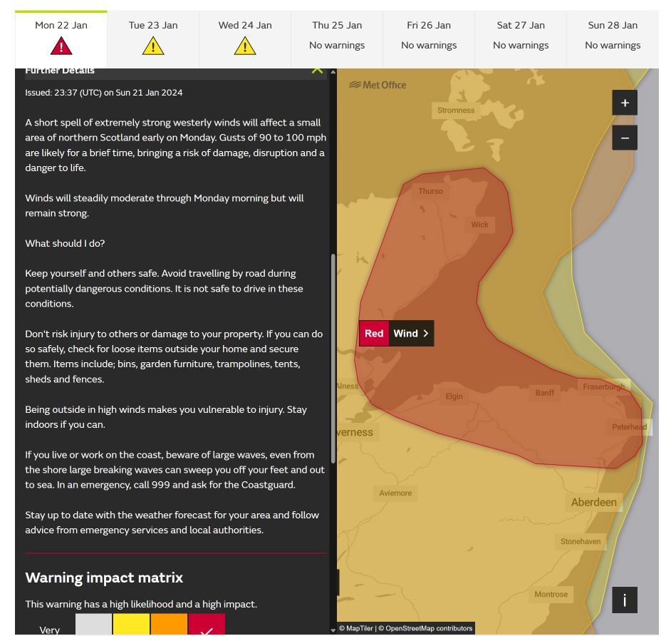
Red warning now out for moray firth area of scotland.  Will probably have been and gone by the time most people see it as it runs 1am to 5am.  Guess there will be significant disruption come daylight tomorrow and not much respite to get power restored before next storm.
UserPostedImage LLTNP 105m asl 
Matty H
22 January 2024 00:06:34

Is that the intense feature showing on the radar over the coast of south Wales now?

Originally Posted by: Rob K 

I can’t see anything that resembles an organised squall line on the current radar. Maybe a tad across NW England 


Yate, Nr Bristol

TBFTEIARBSC

Matty H
22 January 2024 00:13:20

I can’t see anything that resembles an organised squall line on the current radar. Maybe a tad across NW England 

Originally Posted by: Matty H 

Latest Radar image suggests something to the west of Devon/Cornwall 


Yate, Nr Bristol

TBFTEIARBSC

Retron
  • Retron
  • Advanced Member Topic Starter
22 January 2024 03:27:59
An awful night's sleep, with all sorts of worrying noises - and that was sleeping in the back bedroom, rather than my usual room (which is exposed to the full force of the SW winds). Just what you don't want with an eye problem like mine (where a bit of the cornea rips off if you wake up suddenly and open your eyes)...

There was a brief power cut around 9PM last night.

Looks like prolonged periods of gusts into the 60s, so I'm not looking forward to seeing the damage - I think there will be a lot of happy roofers, fencing guys and car "paint correction" companies today! It was the worst storm of the winter so far here.

As for the red warning, smells like a sting jet to me! Here's a screengrab, as Glenogle says - it'll be gone by the time most wake up.

https://ukwct.org.uk/weather/red.jpg 
UserPostedImage


Leysdown, north Kent
The Beast from the East
22 January 2024 04:16:13

An awful night's sleep, with all sorts of worrying noises - and that was sleeping in the back bedroom, rather than my usual room (which is exposed to the full force of the SW winds). Just what you don't want with an eye problem like mine (where a bit of the cornea rips off if you wake up suddenly and open your eyes)...

There was a brief power cut around 9PM last night.

Looks like prolonged periods of gusts into the 60s, so I'm not looking forward to seeing the damage - I think there will be a lot of happy roofers, fencing guys and car "paint correction" companies today! It was the worst storm of the winter so far here.

As for the red warning, smells like a sting jet to me! Here's a screengrab, as Glenogle says - it'll be gone by the time most wake up.

https://ukwct.org.uk/weather/red.jpg 

UserPostedImage

Originally Posted by: Retron 

I am only just going to bed now! Was outside repairing some damage to fencing and retrieving items from next door before they wake up.  What a horrific day and will have to call in a roofer. Worse than Eunice in 2022


Purley, Surrey, 70m ASL

"We have some alternative facts for you"

Kelly-Ann Conway - former special adviser to the President

Retron
  • Retron
  • Advanced Member Topic Starter
22 January 2024 05:57:43
The squall line's going through now - one final cacophany of thumps, clonks and groans coming from outside. It's quite noticable too, here's the graph of wind speed from the yacht club a few miles upwind:

https://ukwct.org.uk/weather/squall3.jpg 

UserPostedImage

EDIT: Shows up well on my temperature graph too. Good riddance Isha, you won't be missed!

https://ukwct.org.uk/weather/temp.jpg 

UserPostedImage


Leysdown, north Kent
Polar Low
22 January 2024 06:19:33
Think we got lucky in this part of Essex maybe gusts of low 50 even squall was ok apart from a 10 minute spell of intense rain.

Darren, Take it easy.


NMA
  • NMA
  • Advanced Member
22 January 2024 06:21:35
10C. Westerly wind and cloudy. Not the worst storm I've experienced last night by any means.
Vale of the Great Dairies

South Dorset

Elevation 60m 197ft

Roger Parsons
22 January 2024 07:19:09
A surprisingly uneventful night here in Lincolnshire, a gusty window-rattling once or twice - nothing sinister. Driving to Woodhall Spa shortly for an exercise class, so the roads may tell a different story.
RogerP

West Lindsey district of Lincolnshire

Everything taken together, here in Lincolnshire are more good things than man could have had the conscience to ask.

William Cobbett, in his Rural Rides - c.1830

Remove ads from site