The Weather Outlook

Remove ads from site

westv
15 December 2022 08:43:26

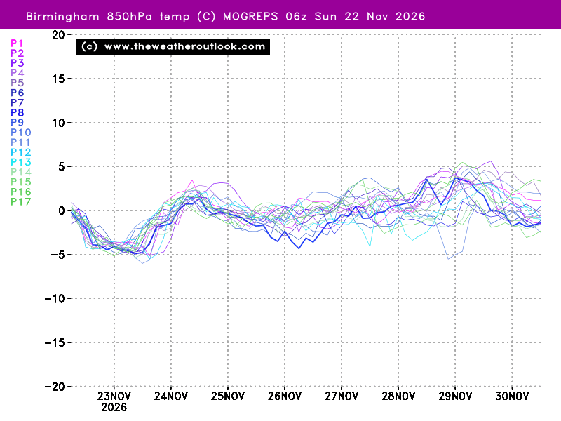
MOGREPS-G also looking milder in the mid term than some of the recent updates. The interest in the next 48 hours will be to see if we are still at the tipping point or if we have tipped.

UserPostedImage

Originally Posted by: Brian Gaze 

on my screen that image reminds me of Wordle.

Brian Gaze
15 December 2022 08:46:54

How do you mean by close to a tipping point? In the sense that you think the next runs will determine whether we end up cold or mild? 

Originally Posted by: Taylor1740 

When the medium term prospects are very sensitive to slight changes in the starting conditions. It's fairly evident that is the case at the moment and there hasn't really been a strong medium term signal from the models for a few days now. 


Brian Gaze

Berkhamsted

TWO Buzz - get the latest news and views 

"I'm not socialist, I know that. I don't believe in sharing my money." - Gary Numan

fairweather
15 December 2022 08:49:43

I just don’t think that’s correct.

Showing Birmingham as a fair example, I see a lot of scatter ranging from cool/cold (uppers around -5C) to mild. Wouldn’t describe it as a sustained warm up. 

I think there is a lot of scatter Joe after Dec 21st but I suspect people are looking for a comparable spell to the one we've just had and not even the lowest in the scatter make the starting point (now) of that graph. I feel a new development needs to spring up, as it might,because the models seem to be showing distinctly average to cool temps till after Christmas I'm afraid.
UserPostedImage


Originally Posted by: Joe Bloggs 


S.Essex, 42m ASL
Brian Gaze
15 December 2022 08:55:01

Yep, and the latest MOGREPS show a mild blip, followed by a cold blip, and then a more sustained warm up.​​  

Originally Posted by: moomin75 

Worth remembering that the UK Met suggest MOGREPS-G is considered as 2x36 rather than 4x18. So the 00z and 06z are paired as are the 12z and 18z. The idea is doing this helps reduce volatility. 


Brian Gaze

Berkhamsted

TWO Buzz - get the latest news and views 

"I'm not socialist, I know that. I don't believe in sharing my money." - Gary Numan

Joe Bloggs
15 December 2022 09:08:35

Originally Posted by: fairweather 

Agree with that but I was challenging the assertion of “sustained warm up” in the latter stages. I wasn’t implying they were a particularly decent set for lasting cold.

Anyway maybe time to move on from discussing whether or not the MOGREPS ensembles show a sustained warm up, there are lots of other models out there and in a few hours this conversation will be meaningless. 😂

Brian Gaze
15 December 2022 09:30:15
The 00z ECM ENS have gone colder.

UserPostedImage


Brian Gaze

Berkhamsted

TWO Buzz - get the latest news and views 

"I'm not socialist, I know that. I don't believe in sharing my money." - Gary Numan

bledur
15 December 2022 09:33:58

We haven’t seen a flake of snow yet and now our roof’s on our annexe, I’d be happy to see a bit of snow. 

Originally Posted by: Caz 

 No snow here either but i did see a few snowflakes one day. There are reports of snow ammounting to 0.25 of a centimtre , which is a bit like a few minutes drizzle being called a wet day.🤣

warrenb
15 December 2022 09:35:48
Thank you Brian, it seems to me that for some people there is only one model in the world and it is the GFS. "Unprecedented setup at the moment" "Never seen a setup like it" just 2 quotes from eminent meteorologists at the moment.

It can go either way, but please look at the big picture when making comments rather than it isn't -5 at 850 in Grimsby a week tomorrow on the GFS , winter is over.


LeedsLad123
15 December 2022 09:37:07

At least it looks likely that Midlands Northwards will see some transient snow on Sunday.  Will only be a couple of hours though for most.  Maybe 3-8cm.  I will plan to go out with the kids between 9am and 12pm whilst it falls and before it starts to melt. 


Originally Posted by: Tim A 

Better than nothing I suppose but snow to rain events really are a bit horrid aren’t they? It’s like getting a lump of coal on Christmas Day. 


Whitkirk, Leeds - 85m ASL.
Heavy Weather 2013
15 December 2022 09:41:46
Fantastic ensembles from the ECM. Eyes down for the 06z GFS which is up and running. Key period remains Mon - Wed next week.

Just to highlight the volatility. My iPhone app has 3C next Fri/Sat now has 5C/7C


Mark

Beckton, E London

Less than 500m from the end of London City Airport runway.

Heavy Weather 2013
15 December 2022 10:07:05
At 96hrs so far and very little change.we are close to the point now where we need to watchthe development of that low south of Iceland. 

Hopefully it doesn’t blow up like it did in tbe 0z


Mark

Beckton, E London

Less than 500m from the end of London City Airport runway.

Tim A
15 December 2022 10:08:21

Better than nothing I suppose but snow to rain events really are a bit horrid aren’t they? It’s like getting a lump of coal on Christmas Day. 

Originally Posted by: LeedsLad123 

Yes, not ideal at all.  They can be ok if they are all snow and then result in slightly milder PM air but still cold enough to keep the snow for a few days, but not in this instance. 


Tim

NW Leeds

187m asl

 My PWS 

Joe Bloggs
15 December 2022 10:10:56
06z GFS out to T+108

Based on past experience it really wouldn’t surprise me if this low takes it time to progress SE, delaying any cold (if it comes at all). These lows have a habit of hanging around like an annoying limpit when we really want them to shift away! 

https://www.wetterzentrale.de/maps/GFSOPEU06_108_1.png 

Heavy Weather 2013
15 December 2022 10:11:52
Everything further east at 120hrs. 
Mark

Beckton, E London

Less than 500m from the end of London City Airport runway.

Heavy Weather 2013
15 December 2022 10:14:16
Good Progress. The low at 145hrs has made far more progression east and should allow for a better northley. It feels alot cleaner on this run.
Mark

Beckton, E London

Less than 500m from the end of London City Airport runway.

Heavy Weather 2013
15 December 2022 10:18:22

06z GFS out to T+108

Based on past experience it really wouldn’t surprise me if this low takes it time to progress SE, delaying any cold (if it comes at all). These lows have a habit of hanging around like an annoying limpit when we really want them to shift away! 

https://www.wetterzentrale.de/maps/GFSOPEU06_108_1.png 

Originally Posted by: Joe Bloggs 

It didn’t seem to get as stuck as the 0z and has made better progress. Not sure where we go from here now.


Mark

Beckton, E London

Less than 500m from the end of London City Airport runway.

Rob K
15 December 2022 10:34:35
We had less than 1cm of snow over Sunday night and it is still on the ground now so although the amount of snow was small I would still call this a decent spell of snow, in a way! It's a shame we didn't have a more usable amount because it's rare for it to stay unthawed for so long.
Yateley, NE Hampshire, 73m asl

"But who wants to be foretold the weather? It is bad enough when it comes, without our having the misery of knowing about it beforehand." — Jerome K. Jerome

Heavy Weather 2013
15 December 2022 10:39:25
The 06z is a great improvement on the 0z up to 220hrs.

I’ll await the ensembles with interest to see if they follow the ECM


Mark

Beckton, E London

Less than 500m from the end of London City Airport runway.

Charmhills
15 December 2022 10:45:31
ECM 00z is cold with some showery snow spreading east at times.

https://services.meteored.com/img/models/ecmwf/ECMWF_168_GB_SFC_fr-FR_fr.png 


Loughborough, EM.

Knowledge is power.

Duane.

Russwirral
15 December 2022 10:49:22

We had less than 1cm of snow over Sunday night and it is still on the ground now so although the amount of snow was small I would still call this a decent spell of snow, in a way! It's a shame we didn't have a more usable amount because it's rare for it to stay unthawed for so long.

Originally Posted by: Rob K 

Yeh feeling is same here.  had a slushy covering which has long since frozen and ore or less bonded with everything.  Small patches remain, but on a walk this morning dusted the odd log, and tree branch.  Combined with the depth of cold, this has felt extremely seasonal  - and on reflection as daft as it sounds  - a rare occurance to such a degree it has been.


Chidog
15 December 2022 10:51:47
This is a cold OP run from the GFS
Heavy Weather 2013
15 December 2022 10:52:24
Priming for an easterly for the latter portion of this run.
Mark

Beckton, E London

Less than 500m from the end of London City Airport runway.

Jiries
15 December 2022 10:54:27

ECM 00z is cold with some showery snow spreading east at times.

https://services.meteored.com/img/models/ecmwf/ECMWF_168_GB_SFC_fr-FR_fr.png 


Originally Posted by: Charmhills 

AT least won't be bone dry set-up this time more like 2021 snow events here from the NW.

Downpour
15 December 2022 11:25:03
GFS 06z run wants to put us all back in the freezer for Christmas, with snow chances for most of the UK around the festive weekend. 

Strange times. Let us see what the ensembles say – its last cold run (18z) was towards the colder reaches of the suite, but was not an outlier. 


Chingford

London E4

147ft

Remove ads from site